For more information about the project, please see our website at: http://pbosnia.kentlaw.edu/projects/warcrimes/.
In an ever-increasing global environment of political change and democratization, greater numbers of isolated citizens are becoming displaced from their homes and their livelihoods. Fueled by political instability, the world all too often witnesses the mass exodus of persons seeking refuge from systematic persecution. As a result, hundreds if not thousands of governmental, non-governmental, and international organizations respond in various ways and to various degrees. Most recently in Kosovo for example, the international community provided over one million refugees with the basic necessities to stay alive.
The effectiveness of international response to these situations is critical to the deterrence of future conflicts and to the enforcement of human rights. Although technology currently only plays a limited role in these situations, it is unquestionable that utilizing the advantages of technology will enhance the effectiveness of the international response to human rights crises. As such, we are developing tools to overcome specific challenges inherent in the international response to these situations.
The War Crimes Documentation Database and Practicum is part of the Illinois Institute of Technologyís InterProfessional (IPRO) Program. IPROs are designed to bring together multidisciplinary students in semester-long, real-world projects. The War Crimes Documentation Project grew out of two earlier IPROs called Project Bosnia, which began in January 1996 as an effort to establish the rule of law in Bosnia by using technology to write, distribute, and record law, and Project Kosovo.
The War Crimes Documentation IPRO brings together engineering, computer science, law and design students and teaches students from across disciplines to tackle the practical, legal and technological challenges posed in the collection of war crimes evidence. The students in this practicum use the aforementioned database to assist in the collection of war crimes evidence for the International War Crimes Tribunal, while they learn about the history of the conflict in Kosovo, about the International War Crimes Tribunal, about how evidence is presented in court, and about how to interview witnesses and how to collect forensic evidence. Over the past years, many students have gone into the Kosovar refugee community in Chicago to interview witnesses, inputting the data into the War Crimes Documentation Database. Other students have had the opportunity travel to Kosovo or Macedonia to collect additional evidence and to work with non-governmental organizations (NGOs) in the Balkans.
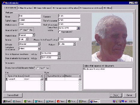
One of the initial tasks of the Project Kosovo team was to create a form to collect information that war crimes prosecutors can use to build their case. Using this form, a witness is interviewed and his or her testimony is summarized in English and stored in the database. A digital audio recording of the testimony (in Albanian) is also stored in the database in the event that war crimes prosecutors need more detailed information. Digital video recordings of crime scenes or scanned documents relevant to a particular case may also be saved in the database to be used by prosecutors. If it becomes necessary, the prosecutor can then call the witness to appear in court to testify in a given case.

Three delegations from Chicago-Kent College of Law, Illinois Institute of Technology field-tested the War Crimes Documentation Database when they visited refugee camps in Kosovo, Albania, and Macedonia in the summer of 1999. Moreover, three students spent their summer vacations working in the region collecting war crimes evidence. Working in cooperation with the American Bar Associationís Central and East European Legal Initiative (ABA CEELI), the Soros Foundation, Samaritanís Purse, the International Rescue Committee, Organization for Security and Cooperation in Europe (OSCE), the United Nations High Commission for Refugees (UNHCR), and the Center for Peace through Justice, we are successfully collecting hundreds accounts of refugees describing war crimes.
Using GIS in conjunction with humanitarian aid is a relatively new application of the technology, but a logical connection. Refugee relief programs and war crimes documentation efforts are both locational in nature. The information collected in these efforts may be compared with information about troop movements to validate the integrity of the evidence. Yet, the connection between humanitarian aid/human rights support and GIS is not without its difficulties.
To address these problems, the Project Kosovo group first created the War Crimes Documentation Database. The team developed the application with the intention to meet the needs of many NGOs, so that the data collected between them could be shared and built upon. The team worked specifically with ABA CEELI and the Center for Peace through Justice to create a workable and useful project. The original database product was created in Access 97. As the project expanded, Project Kosovo partnered with Sun and Oracle, leading technology companies which generously provided the hardware and software to create a more robust and complex database in Oracle.
As the team continues its work with ABA CEELI and the NGOs in the Kosovo region, the goals of the project continue to expand and evolve. Over the last several months, the team has focused on the following three goals:
First, to create an application that is useful not only for this conflict, but that can be reused in conflicts around the world. The satisfaction of this goal required that not only a database be built, but that a template through which NGOs can create a customizable and reusable database be built. The template created allows for flexibility but also guarantees that all users of the application work off of the same database structure. This guarantee of identical structure means that all users of the application will be able to share data, even if they create their databases differently.
Second, the team developed a standardized vocabulary in conjunction with ABA CEELI. Using a standard vocabulary list to describe war crimes will promote use of these interviews as evidence in war crimes indictments.
Third, the team focused on using GIS technologies to enhance the usability of the database application. They determined that there are three main ways to make use of GIS in relation to war crimes documentation: as a visualization tool, as a means to determine exact locations (in latitude and longitude) of sites and events, and as a tool to spatially query and analyze the collected data.
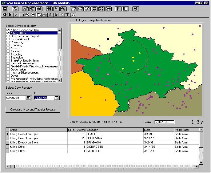
The original GIS component of this project relied on Esriís ArcView application. The collected war crime records (approximately 1,000 interviews) were stripped of personal information and imported into ArcView. The GIS team then experimented with displaying the information in different ways, for example using themes to represent changes in crime locations over time. ArcView is extremely useful as a visualization and analysis tool. Users were now able to spatially query the database, pulling out records for crimes that occurred with a specified radius of a given location.
The team considered ways in which it could make ArcView functionalities available to users in the field. They considered purchasing licenses for ArcView or recommending NGOs download Esriís ArcExplorer. The team also experimented with using Avenue to simplify the user interface for use with the database.
Eventually, the project hired a Delphi programmer to move the original Access database into an Oracle structure that would fulfill its goals. The recreation of the database provided an opportunity for the team to implement GIS capabilities into the database application itself. Using Esriís MapObjects, the GIS module was born.

The primary use of the GIS module will be to query the database spatially and display the results on a map and in tabular form. To do this, users will set three criteria: the types of crimes they are investigating (multiple crimes may be selected), the date range they are interested in, and the region they are investigating. (To select the region, they will use the draw tool to outline a shape. If they are interested in the entire region, they may outline all of Kosovo.)
The ability to query the database by location will be immensely important for NGOs documenting evidence of crimes against humanity. The query results could be overlaid with satellite imagery showing the movement of enemy forces in certain regions of Kosovo or with GPS files marking locations of mass grave sites. Thus, evidence detailing crimes and perpetrators could be linked to locations of suspected or indicted war criminals.
This resource will be made available to NGOs at no cost. In order to guarantee the GIS moduleís (and the entire WCDD) usability, the database application will be thoroughly tested by users from several NGOs now working in Kosovo. The WCDD must be simple enough to use without much training, but robust enough to provide good data to the users in the field, lawyers, statisticians, and the war crimes tribunal.
One of the greatest obstacles for this project has been the lack of good spatial data for Kosovo. Very few ready-made themes of this area exist and full development of the GIS module will include hand digitizing of relevant information. Another problem is that place names in Kosovo are spelled differently in Serbian and Albanian. The language difference leads to many problems in geocoding data.
A second obstacle is that the current users of the application are unaware of the potential GIS may have on their work. These volunteers are unaccustomed to collecting spatial data as related to crimes in greater detail than by city name. One of the intended uses of the GIS module is as an locational input tool. Ideally, volunteers working with refugees would be able to pinpoint exact locations of events by having witnesses identify crime scenes on high-resolution satellite imagery. In order for this goal to be achieved, however, users must feel comfortable using the application rather than the paper and pens they are accustomed to using. Achieving this level of comfort will require significant amounts of training of users.
The combination of these two obstacles results in limited locational information for GIS analysis. Currently, war crimes are linked to city names. The generality of this approach does not allow for display of rural data, such as the locations of mass grave sites, or of locations in different parts of cities. The War Crimes IPRO will continue to partner with relief organizations and GIS data providers worldwide to develop solutions to the existing data obstacles.
The GIS module will be unveiled with the latest version of the War Crimes Documentation Database in September, 2000, at the International Criminal Tribunal for the FormerYugoslavia meeting in the Hague. The application will also be shown at the Independent International Commission on Kosovo meeting in late fall in South Africa.
The War Crimes Documentation Project would like to thank Esri for its generous support of this project. We would also like to acknowledge that the creation of this application would not be possible without the support of Sun Microsystems and Oracle, Inc.
Alison Atkins is the Assistant Dean for Special Projects and GIS at the Illinois Institute of Technologyís Galvin Library. Ms. Atkins received an M.S. in Information Science from the University of Michigan in 1996. She has been an advisor to the War Crimes Documentation Project since 1999. Ms. Atkins may be contacted at 312.567.3615 or at atkins@iit.edu.
Special thanks to IV Ashton, Chicago-Kent College of Law, for his contributions to this paper.