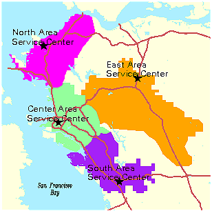
Figure 1. Current East Bay Municipal Utility District Service Centers and Service Center Boundaries.
The East Bay Municipal Utility District is a large public water and wastewater district encompassing a portion of two heavily populated counties in Northern California. In order to reduce the time crews spend driving to job sites, district staff began looking at the efficiency of its service centers for handling maintenance activities throughout the District. A GIS location-allocation analysis became the foundation and basis of the study. Using GIS technology, the District was able to model its entire maintenance program, identify/quantify the inefficiencies, and determine what modifications would be necessary in order to reduce its non-productive hours by up to 28%.
The East Bay Municipal Utility District (EBMUD) is located in the San Francisco Bay Area in Northern California and covers portions of Contra Costa and Alameda Counties. EBMUD delivers water to 23 cities and communities with over 1.2 million customers. The EBMUD water distribution system consists of over 3,800 miles of pipe in 123 separate pressure zones. Water is supplied from the Mokelumne River watershed located 100 miles East in the Sierra Nevada Mountain Range. Water is stored in Pardee Reservoir at the base of the watershed, and is conveyed through the Mokelumne Aqueduct to the EBMUD service area.
Maintaining the large and complex EBMUD water distribution system is aggravated by several factors. Many parts of the system are aging, with pipes dating back to the 1800’s. In addition, the topography, soil types, seismic activity, and transportation pressure constantly challenge the system. On an annual basis, the District experiences an average of 800 main breaks, 600 valve/appurtenance repairs, 120 hydrant repairs, and 500 lateral repairs and 500 service installs, as well as other miscellaneous maintenance repairs. In addition, as part of its infrastructure renewal program, the district replaces approximately 8 miles of pipes per year. Finally, during the late 1970’s and early 1980’s the district installed a large number of polybutylene laterals that have now begun to fail. As these laterals fail they are replaced with non-polybutylene laterals. On average there are 1,200 polybutylene replacements each year.
In order to respond to the scheduled and unscheduled maintenance activities throughout the District service area, four maintenance yards were established (see Figure 1). Work orders within each of the service yard boundaries are assigned to crews stationed at the respective service center. Equipment and material for each job is stored mainly at the service centers, with smaller storage bin and temporary equipment parking stations located in various places throughout the district.
Figure 1. Current East Bay Municipal Utility District Service Centers and Service Center Boundaries.
Placement of the maintenance yard service centers and the boundaries of the service yard areas were established back in the 1940’s, 1950’s, and 1960’s based on the demographics, transportation, and infrastructure situation at the time. Since that time, population has increased and the system has aged, shifting much of the workload from previous areas to new areas. Maintenance crews are increasingly spending more time driving to and from work locations, causing the District to reassess its placement of maintenance yards and service centers.
A quantitative method was needed to assess the current efficiency of service center locations with respect to the overall maintenance demand of the distribution system. In addition, the method needed to be able to assist in locating optimal locations for future service centers, and for comparing the efficiency of proposed service centers to existing service centers for cost recovery purposes. Finally, the analysis needed to be performed in a timely manner, with minimal staff and monetary resources. A GIS Location-Allocation analysis was the perfect solution.
Location-Allocation modeling offered the best solution for studying the efficiency of service center locations at the District. Using historical locations of various maintenance activities as demand on a transportation network, the District was able to compare the amount of time spent by crews driving to and from each maintenance location from each service center scenario. By comparing the total drive times between the existing situation (baseline), with various additional proposed facilities, cost savings could be determined and weighed against the proposed costs of acquiring and building the additional service centers. In addition, once the proposed service centers were approved, a new service area boundary map could be generated based on the workload allocated to that center.
The main components of the GIS Location-Allocation model were:
A detailed street coverage from the Thomas Brothers Maps ® was used as the network component of the model. Since the Thomas Brothers street coverage was not built as a directional network, a turntable was created based on attributes within the attribute table. An automated process was created to assess each turn in the table and impede all impossible turns. For example, surface streets were not allowed to turn directly onto freeways or off-ramps, and freeways were not allowed to turn onto on-ramps. In addition to data from the Thomas Brothers coverage, streets restricted to truck traffic were added to the attribute table and impeded as well.
Right hand and left hand turns were assigned a cost of 5 seconds and 10 seconds respectively. This was done to simulate the cost of slowing down for a turn, and for turning against traffic (where possible). In order to simulate the speed at which trucks travel, maximum speeds were assigned to each road type. A basic impedance factor was then assigned to each maximum speed limit to simulate the overall cost of traffic. The impedance factor attempted to account for traffic congestion, traffic lights, speed bumps, and other traffic slowdowns.
The transportation model was then calibrated with actual truck driving times under various driving conditions. A series of pre-set routes were generated from the model and driven by truck crews at various times of the day. In addition, several truck crews recorded routes and drive times to their work locations. These results where then used to calibrate the model by adjusting the impedance factors for each road type. Because the conditions were extremely complex, with each road giving a unique set of circumstances, it was decided to use an overall impedance factor to account for the slow downs in drive times.
Although not enough data was collected to perform a true statistical analysis, there seemed to be a good correlation between the drive times recorded by truck crews and the drive times simulated by the model. Table 1 shows the final speed limits and impedance times assigned to each road type. The estimates are conservative as they do not account for peak commuting times.
Table 1. Road types, maximum speed limits, and adjusted speed (roadtypes courtesy of Thomas Brothers Maps ®).| Road Type | Maximum Speed Limit | Adjusted Speed Limit |
| Freeway | 65.00 | 31.20 |
| Roadway (default freeway code) | 65.00 | 31.20 |
| Freeway Ramps & Interchanges & Feeders | 25.00 | 12.00 |
| Freeway On-ramp (only) | 25.00 | 12.00 |
| Freeway Off-ramp (only) | 25.00 | 12.00 |
| Freeway On and Off ramp (combination) | 25.00 | 12.00 |
| Freeway Interchange | 60.00 | 28.80 |
| Highway | 50.00 | 24.00 |
| Primary (arterial) | 35.00 | 16.80 |
| Secondary (residential collector) | 21.00 | 10.08 |
| Minor (residential - unclassified) | 25.00 | 12.00 |
| Alley | 5.00 | 2.40 |
Work locations were extracted from the District’s General Work Order Management (GWO) and Paving Order Management (PVO) systems. Both systems are located in the Districts Oracle Enterprise Data Repository. The work locations were geocoded using two techniques. A first pass on all records assigned coordinates to work orders with addresses that matched the District’s service tap location table. Work orders that did not match a service location were geocoded in ArcView using an unsupervised US Street with Zone style address matching on the Thomas Brothers street coverage. Since the address matching was unsupervised, only locations with a matching score of 80 or greater were used. Approximately 85% of the work orders were geocoded using the two techniques.
Infrastructure renewal locations were taken from the Districts Pipeline Replacement GIS Application. This application contains proposed pipeline replacement information in ArcView Shapefile format.
Because of the variation in crew accompaniments, equipment requirements, and department responsibilities for crews that respond to the different types of work orders, the work orders were categorized and analyzed separately. The seven maintenance activities studied were:
The number of trips to and from each work site was determined separately for each maintenance activity, and were based on factors such as the typical number of vehicles in a crew, the size of the excavation, and the length of the pipeline replacement. Demand at each work location was then adjusted dynamically from each of the above factors.
Existing service center locations were extracted from the Districts Oracle Enterprise Facilities Database. Proposed service centers were geocoded by street address, or were taken from the Facilities Database if it was an existing District facility to be converted.
Each of the maintenance activities was studied separately. A baseline analysis was performed for each activity using the locations of existing service centers and storage bins. Proposed facilities were then added and analyzed against the same demand. In some cases, proposed facilities were assigned limited capacities because of various factors such as limited hours of usage or limited storage space. The model produced the total amount of time spent driving to and from all of the work order locations for each scenario. The total drive time was then converted to man-hours by estimating the number of crewmembers assigned to the respective maintenance activities. Finally the total man-hours were converted to dollar figures based on the average hourly rate for the crew complements.
Once the model was established, it became easy to change the proposed facilities for each activity, and assess the overall reduction in drive times and costs. This allowed the engineers and planners to assess many different scenarios and "what if" situations.
As a first cut and guide to locating optimal facility siting locations, several possible center locations were determined by superimposing a grid on top of the different maintenance activity locations. A center was created within each grid cell based on the mean work location within that cell. then letting a location-allocation analysis determine which of the sites was optimal. Figures 2 through 4 show the process of determining the optimal facility sites. The engineers had a good idea of how many sites they would be able to acquire and build, so the number of facilities was limited. This "first cut" allowed the planners to begin locating existing EBMUD facilities, or possible acquisitions close to the optimal site locations. These optimal site locations were used only as a guide in locating possible maintenance facilities.
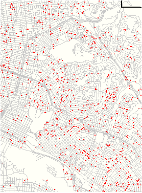
Figure 2. Process of determining optimal locations. In step one, locations of historical work orders (mainbreaks) were plotted on a street network.
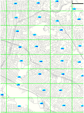
Figure 3. Process of determining optimal locations. In step two, a grid was superimposed on the work locations. The mean location of the work locations within each grid was used as a possible service center.
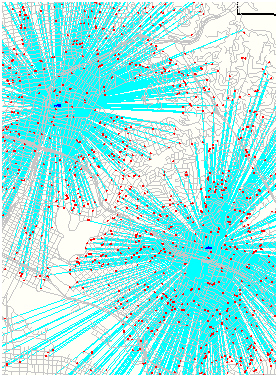
Figure 4. Process of determining optimal locations. In the final step, each of the centers determined in step three were evaluated. The location-allocation model chose the optimal sites, allocating the historical work locations to each service center.
For each maintenance activity type, a "baseline" analysis was performed using the existing EBMUD facilities as service centers. From this analysis, the existing drive-time was determined and used as a base to compare to the proposed facilities. Proposed facilities were then introduced as additional service centers, and in some cases existing facilities were removed. When a facility's capacity for receiving work was impaired for some reason (such as limited capacity or limited hours of operation), the amount of work allocated to that facility was limited with a capacity cap. The resulting drive-time hours were then compared to the baseline hours for a quantitative assessment of the scenario.
Figures 5 and 6 show the graphical model output for the Baseline and Proposed analysis results on Polybutylene maintenance activities. Figure 7 shows the typical drive time model statistical output. The results were broken down by facility, so that the efficiency of each facility could be determined.
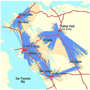
Figure 5. Baseline Analysis Results for Polybutylene Repair Service Centers
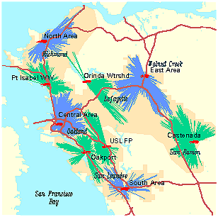
Figure 6. Proposed Analysis Results for Polybutylene Repair Service Centers (green radial lines show proposed facility allocation).
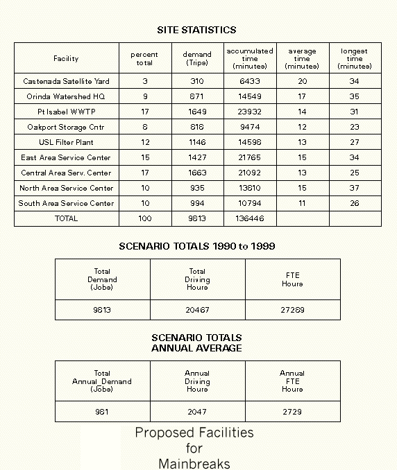
Figure 7. Example model output statistics.
Table 2 shows the baseline vs. proposed facility results for each of the maintenance activities studied. The overall reduction in the amount of drive time was approximately 28%. This equated to a dollar figure of between 3 and 5 million dollars per year. An added benefit from the GIS model was the graphical output and quantitative model results. These benefits helped District staff in proposing the capital expenditure for the proposed facilities.
Table 2. Comparison of Baseline vs. Proposed Facility Drive-Times| Maintenance Activity | Baseline Driving Hours | Proposed Driving Hours | Percent Reduction in Hours |
| Mainbreaks | 3,584 | 2,729 | 24% |
| Service Renewals | 1,596 | 1,037 | 35% |
| Service Repairs | 1,573 | 1,189 | 24% |
| Service Installs | 1,402 | 1,079 | 23% |
| Hydrant Repairs | 278 | 216 | 22% |
| Polybutylene Repairs | 4,730 | 3,267 | 31% |
| Valve/Appurtenances | 1,342 | 1,012 | 25% |
| Pipeline Replacement | 6,984 | 5,000 | 28% |
| Total | 21,490 | 15,529 | 28% |
In addition to the proposed facilities, the study illustrated a new way of looking at work allocation for existing facilities. With time, many of the maintenance yard boundaries had become "rigid", with crews seldom crossing boundaries unless absolutely necessary. The study showed that some of the existing maintenance yards could better be served by allowing some "cross over" of maintenance crews.
Although not all of the facilities sited by the study were approved for construction, the model results will have far reaching benefits to the District. The amount of time spent building the transportation network will be leveraged with future maintenance crew dispatching applications. In addition, new service yard boundary maps can be generated that are based on travel time rather than city boundaries or other artificial boundary decisions. Finally, the model calibration will be improved by data from the Districts GPS Vehicle Tracking System that will be on-line in the near future. This system will begin tracking locations and transit times of all EBMUD vehicles. This data will be fed back into the transportation model for improved impedance factors.
In conclusion, use of the GIS location-allocation model saved the District time and resources. The study was conducted in six months, with one full-time engineer and one near full-time GIS Analyst/Programmer. The project came in well under budget, and did not require any additional outside consulting assistance. The graphical output and quantitative results assisted planners and engineers in proposing the additional facilities to upper management. In addition, the time and resources spent on the project will be leveraged in future applications to further save the District time and money.
Thomas Brothers Maps ®
Digital Data Dictionary
Version 4.2.1
April 28, 1999