Boca Raton, Florida is a city of 70,000 residents situated within Palm Beach County. Boca Raton has a population increase during the winter months to approximately 86,000. The city has worked with Palm Beach County to develop GIS capabilities through acquisition of land base and parcel data. Boca Raton uses an IBM AS/400 operating software by HTE, Inc. from Orlando, Florida. HTE produces software modules designed for local government management of information related to land management, building permits, occupational licensing, code enforcement, planning and zoning, and several other activities. Boca Raton is integrating data contained in the HTE system with its GIS. To accomplish this, Boca Raton is implementing SDE for Oracle to store and manage the spatial data, and ArcView and MapObjects IMS to provide user access to the spatial data linked to attributes coming from the HTE modules. This paper describes the issues encountered during GIS implementation and HTE integration activities.
The City of Boca Raton, FL is implementing a City-wide Geographic Information System to better serve the public both directly through access to data resources and indirectly through increased efficiency of City staff. The long-term focus of GIS implementation at the City is citizen oriented. The highest priority applications of the technology will involve improving the speed and quality of response to citizen needs. The GIS will be used to improve the safety and welfare of the citizens, and to provide an experience as pleasant as possible when citizens interact with City staff. These goals will be achieved through the development of GIS applications that will increase staff efficiency, and provide easier citizen access to both City related statistical data and the associated digital maps. The Internet is envisioned as the primary medium for providing this access. Public access must evolve from applications used and tested within the City to ensure proper operation and data accuracy. As the first step toward developing these capabilities, the City has been involved in implementing GIS technology in a configuration that provides GIS data access to as many City staff as possible in a cost effective manner. One important aspect of this process has been the integration of data managed and maintained through software modules from HTE, Inc. To begin the HTE integration process and establish a web-based GIS application, a prototype project was designed and implemented. The prototype consisted of the creation of a database accessible to City staff in many offices and the implementation of some GIS applications beneficial to the City staff. As a precursor to the availability of data to citizens through the Internet, the prototype included a component that operated over the City Intranet.
HTE software operates on an IBM AS/400 computer. It is composed of a series of integrated modules that perform specific municipal functions and access parcel-related information from the LX Land Management Module. The HTE modules in use in Boca Raton include:
* LX module
* Business Licensing
* Code Enforcement
* Building Permits
* Accounts Receivables
* Customer Information System (Utility Billing)
* Planning and Zoning
* Fixed Assets
* Purchasing/Inventory
* GMBA (Accounting) General Ledger Accounts Payable
* Cash Receipts
The LX module contains a database composed of tables holding parcel and owner information. Various other modules use the LX module tables to relate specific module information to the parcel and ownership data. The LX module provides the means of relating all the data associated with the regulatory, inventory, and financial systems to geography in the form of City parcels. Therefore the first step to achieving the capability for analyzing these data in a spatial context is to successfully link the LX database to the parcel data through the GIS. The prototype GIS implementation project was conceived as a means of testing some of the methods for accomplishing that link. The project created a central GIS database consisting of land base data representing the physical features within the City and its utilities service area, and parcel and street centerline data received from the County covering the same area. Once the geographic database was developed, the goal of the prototype project was to provide access to that database for City staff. The HTE LX database was made available as attributes to the parcel data. Various approaches for integrating the HTE data with the GIS data were attempted.
The Prototype Project consisted of two primary elements:
1. Creation of the database
2. Providing access to users
Two approaches were considered for each of these elements. The approaches were compared and discussed with City of Boca Raton Information Services staff. After considering the results of the comparison, a final approach was determined for the Prototype. The final approach was then implemented and the resulting database and applications were made available to City staff.
Palm Beach County maintains parcel data for the entire county through the Palm Beach County Property Appraiser's Office. The City has no tax assessment or tax mapping duties. All data are received from the County. The County has significant GIS capabilities and seeks opportunities to cooperate with municipalities within the County. The City of Boca Raton established an inter-local agreement with Palm Beach County to obtain the digital parcel map from the County Property Appraiser. The City also contracted with the Palm Beach County GIS Service Bureau for the translation of the City's planimetric land base data into ArcInfo coverages.
Boca Raton was able to arrange for the translation of the land base data from AutoCAD to ArcInfo coverages by the County. The County also delivered digital parcel data to the City in ArcInfo format. The City acquired Oracle and an Esri Spatial Data Engine (SDE) software license for the Oracle server. The parcel and land base data were translated into the SDE format and loaded onto the City data server. Accessing the attribute data to be linked to the parcel database was attempted in two ways. The approaches tested for creating the attribute database included:
1. Establishing a live link to the HTE database on the AS/400
2. Creating extracts of the LX module tables and using the extracts to establish Oracle tables that mirror the LX module tables on the AS/400, then linking the GIS data to the Oracle tables.
Two applications were developed to provide GIS access to City staff. The applications were both based on Esri software and both accessed the same SDE GIS database. The applications had some similar functions, but there were some important differences. The software used to create the applications had different characteristics, although they operated with the same data. The two applications developed were:
1. An Intranet based view and query application based on MapObjects Internet Map Server software. This application provides access to GIS data for all staff linked to the City Intranet through an Internet web browser.
2. An ArcView based application for view and query, creation of plots, and some specific tasks such as thematic mapping of assessment data, thematic mapping of utility billing data, and the creation of mailing lists based on proximity of properties to a selected property.
Each approach was evaluated based on several factors that were important to the City of Boca Raton. Each approach has advantages and disadvantages that make them suitable for certain situations and not for others. The factors used for evaluation are based on the needs associated with the situations that exist in Boca Raton. These factors include the following:
* Database Security - Any application that accesses HTE data must include provisions for protecting the integrity of the HTE database. Users must not have the opportunity to change any of the data stored in the system.
* Ease of Use - Most of the City staff are not familiar with GIS technology and a simple interface is required to provide many of them with access to the GIS data that they will be able to effectively use.
* Level of Functionality - Some users require specific functions beyond display and query of data. Creation of thematic displays and maps, creation of standard plots, and the generation of mailing lists based on proximity of properties to a selected property were capabilities that were required by specific staff.
* Currency of Data - It is important for users to know how current the attribute data are. The most current version of the data will be the actual HTE tables stored on the AS/400. Oracle tables derived from HTE table extracts must be updated at an interval that is appropriate for the uses of the applications that access them.
* Distribution to Users - There are many City staff that will benefit from access to the GIS data for view and query purposes. One approach involved the development of an application deployed through the City intranet and accessed through a web browser. The other approach requires installation of the software and the application code on the client machine. Distribution is more cumbersome and more costly using the second method.
* Consistency of Database - It is important that all users in the City access the same GIS data and the same attribute data. Although it may be possible to link to attribute data directly from the AS/400 as well as through Oracle tables, all applications and installations must access the same set of data to avoid confusion or inconsistency of attributes that could occur with such a situation.
Below is a comparison of the results of all combinations of approaches for the creation of and access to the attribute database as well as the applications developed to provide access and functionality.
The connection to the HTE tables occurs through ODBC. The connection occurs through the data server and users will have no capability to change values in the HTE tables, even though an ODBC connection to the tables is not regulated access. The application is a simple display and query application that is View-only. The interface is simple enough to be used by any City staff with minimal training, and it is cost effective to deploy. The application operates through the City intranet and requires no software on the client machine other than an internet browser.
Extracts are created in HTE on the AS/400 and placed in an assigned directory. When necessary, PL SQL scripts are run to create Oracle tables from the HTE extracts. The application accesses the Oracle attribute tables. The application is a simple display and query application that is View-only. The interface is simple enough to be used by any City staff with minimal training, and it is cost effective to deploy. The application operates through the City intranet and requires no software on the client machine other than an internet browser.
The connection to the HTE tables occurs through ODBC. The application and the software operate on the client machine requiring the connection to be established through the client machine. Since the ODBC connection provides unregulated access to the HTE tables, any user has the capability to alter table entries. Due to these circumstances, this approach is unacceptable.
Extracts are created in HTE on the AS/400 and placed in an assigned directory. When necessary, PL SQL scripts are run to create Oracle tables from the HTE extracts. The application accesses the Oracle attribute tables. The application is a customized version of the ArcView interface. It provides some specific functions beyond display and query of data. It requires more training for a user to learn and operate, and over time a user will be able to use the ArcView capabilities to conduct their own analysis and create their own maps. This application requires that ArcView software be loaded on a user's machine and is therefore more expensive to deploy than the MapObjects application.
It was verified that the GIS parcel data stored in SDE format could be linked to an HTE table through ODBC. Because of the security problems associated with establishing an ODBC connection for every ArcView client it was considered necessary to create a set of Oracle tables derived from HTE table extracts.
It was determined that both the ArcView application and the MapObjects IMS application were needed to provide the combination of capabilities for a few staff and the widespread access and ease of use for the majority of the City staff.
Consistent access to a single GIS database and a single attribute database was considered necessary. Due to the security problems associated with accessing the tables residing on the AS/400, it was necessary to create Oracle tables from HTE table extracts. Both the MapObjects IMS application and the ArcView application were designed to access the Oracle tables.
A description of the final approach that was designed for the implementation of the Prototype follows:
GIS data was loaded into an SDE geodatabase stored in Oracle software on an IBM NetFinity GIS data server running the Windows NT 4.0 operating system.
The tables associated with the HTE LX module database were copied as ASCII file extracts. The extracts were placed into a directory on the GIS server and PL SQL scripts were run to create Oracle tables that were used to provide the parcel attributes. Two methods were tested for creation of extracts:
1. Comma delimited ASCII files.
2. ASCII files with fixed length fields.
Creating comma delimited ASCII files using the AS/400 took several times longer than creating fixed length fields. On the Oracle side, creating tables from comma-delimited files was faster than using fixed length fields. In Oracle the difference in time was only a matter of minutes while the time difference between creation of comma delimited and fixed length on the AS/400 was a matter of hours. As a result, the HTE table extracts were created as ASCII files with fixed length fields.
A script was written that triggered the process for creating new Oracle tables from the extracts that had been placed in a designated directory. The script can be run interactively or according to a scheduled time.
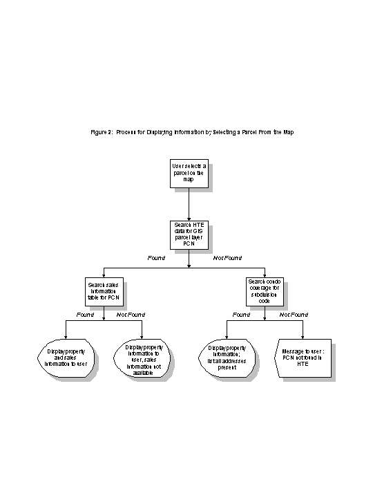
A MapObjects IMS application was developed to provide display and query of all GIS data layers. A large portion of the development effort involved identifying the entity relationships among the fields in the attribute tables and coding SQL queries that returned the proper results. Several issues had to be resolved in the course of the application coding. Parcel numbers in Boca Raton and all of Palm Beach County are composed of a series of numbers that represent city, section, township, range, subdivision, block, lot:
* Multiple condominium parcel records that relate to single land parcels - All condominiums have parcel numbers since they are individually owned, but for each complex there is one land parcel that is the location of multiple condominium units. A shortened parcel number is used to indicate that land parcel. The number was shortened to the subdivision code with no reference to block or lot. To allow users to input an address of an individual condo unit, and have the application locate the land parcel associated with that address, the applications were coded to identify condominium addresses and match only the portion of the parcel number that includes city, section, township, range, and subdivision to the GIS parcel data.
* Multiple addresses that related to a single land parcel (apartments, office buildings, strip malls) - All properties with a single ownership, but multiple addresses such as an apartment complex have records in the LX module for every address. All those records contain the same parcel number, but only one record links to ownership data that exists in other tables. That record is signified through the use of a flag value called "main" that is entered into a field in the record. When the applications encounter apartment addresses they are coded to look for the main record and use that record for linking to other tables and providing values to be reported to the users.
Two diagrams were prepared (see Figures 1 and 2) that model the logic used in the GIS applications that were developed.
Errors caused by the entry of addresses that could not be found in the attribute database caused the MapObjects IMS application to shut down. An error catching routine was added that created a record of errors and kept the application operating after notifying the user that the address could not be found.
An ArcView application was developed that provides display and query capability as well as thematic mapping of utility billing and assessment data, and the capability to generate mailing lists of property owners within a specified distance from a selected property for various notification purposes. The application also provided the ability to create some standard plots of the GIS data.

In the future Boca Raton will have the opportunity to continue integrating the HTE modules with GIS data. As more GIS capability becomes available through the internet based applications, there will be opportunities for increasing the importance of the Intranet application and possibly for linking all GIS applications directly to HTE tables. This will improve the currency of the data that will be available through the applications. When other HTE modules are integrated such as building permits, code enforcement, and occupational licensing, database currency will become a more important issue than it is presently.
The authors wish to acknowledge the efforts of Heidi Hammel and Minna Li for their efforts in the completion of this prototype project. Their technical expertise was essential for the success of the effort, and made the writing of this paper possible.