Abstract: Comprehensive Field Data Gathering Techniques
John Cestnick, Woolpert LLP
Woolpert, a leader in GIS/GPS technology integration, continues to develop field data gathering tools to support the water, wastewater, and storm water industries as we showcase the latest in software applications in this paper/presentation. Our latest application includes the integration of various surveying tools (including GPS and conventional survey equipment) seamlessly within an Esri MapObjects environment, while also providing built-in network topology QA/QC. The ultimate goal is to minimize data translations from one of more off-the-shelf application to a single platform, which dramatically improves data flow, field crew efficiency, and overall accuracy
SMARTSurveyor Software
SMARTSurveyor is a proprietary mobile mapping system that enables survey crews to map water, sewer, and storm water utility systems and structure attributes on-the-fly, with complete network connectivity, in a single sweep. Developed by Woolpert LLP, this software links data output from Trimble GPS receivers, and conventional survey total stations, to create or update GIS data that contains positional and attribute information.
The technology used in SMARTSurveyor integrates accurate positioning capabilities into an Esri MapObjects-based GIS system that field crews can use to establish network connectivity while they are in the field performing the data collection.
Utility Inventory versus Utility Field Mapping
In the not-too-distant past, field crews were restricted to performing what can be termed a utility inventory survey. This consisted of positioning all above ground utility features, but recording very limited feature attribution.
Currently survey crews are capable of much more. With SMARTSurveyor software, crews are able to perform full utility mapping surveys. Utility mapping should be considered performing not only an above ground utility inventory, but to also include a sub-surface inventory. This would include recording a significant number of attributes such as pipe diameters and materials, manhole condition, invert depths, evidence of inflow and infiltration, and even building the connectivity of the system while in the field.
Why Was SMARTSurveyor Software Developed?
Whether it’s water, sewer, or storm water, having vital utility system information at your fingertips is every utility manager’s dream. But getting that information into a graphic, easy-to-use format can be a nightmare. SMARTSurveyor software was developed to assist in capturing the required data in the proper format.
Governmental Accounting Standards Board
Adding to the torment is a recent governmental mandate issued by the Governmental Accounting Standards Board (GASB). The mandate, known as Statement 34, requires public agencies to report all capital assets, including utility infrastructure assets. This means municipalities will be scrambling to develop inventories of their utility infrastructures, including water, sanitary sewer, and storm water, to determine an accurate starting point for meeting Statement 34 requirements.
The mandate requires a total net depreciated value of those assets, a daunting task for most utilities and public works agencies. But, there is an alternative approach. Assets that are part of a utility network, such as storm water, water, and sanitary sewer systems, are not required to be depreciated if two requirements are met. The first states the government agency must manage the eligible utility infrastructure assets using an asset management system, and the second states the government agency must document that the utility infrastructure assets are being preserved at a condition level established and disclosed by the government.
To meet the first requirement, a standard must be established. To do this the agency would need to:
Statement 34 doesn’t require agencies to perform a physical utility inventory / mapping survey, but it does require a starting point for measuring those assets. The only way to assure yourself of an accurate starting point is a physical inventory.
To help facilitate this, a new system combines a mapping application with GPS software to deliver a GIS-based field data collection and mapping solution for utility mapping projects. Woolpert has had many clients request utility inventory surveys and utility mapping surveys. A client’s needs and circumstances will dictate which type of survey would be best. For example, a client with accurate and up-to-date source documents might request only a utility inventory survey since source documents can be trusted to build utility connectivity. They might also request RTK GPS technology if they require accurate vertical positioning.
On the other hand, some clients request a utility mapping survey because their source documents have not been kept up-to-date and are not trustworthy. In these situations, some of the most important information required by the client is how the utility is connected and how it is flowing. If funding is also a problem, and vertical information is not critical, the client my then decide to utilize RTD GPS technology to save money and increase delivery time.
Before SMARTSurveyor was developed, no software was available with all the capabilities needed to productively perform both a utility inventory and a utility mapping survey. Because of this, Woolpert developed SMARTSurveyor with the following capabilities in mind:
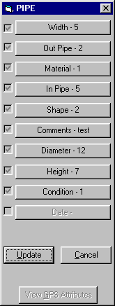
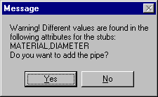
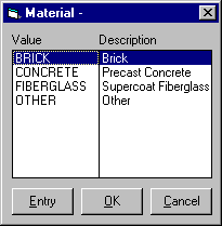
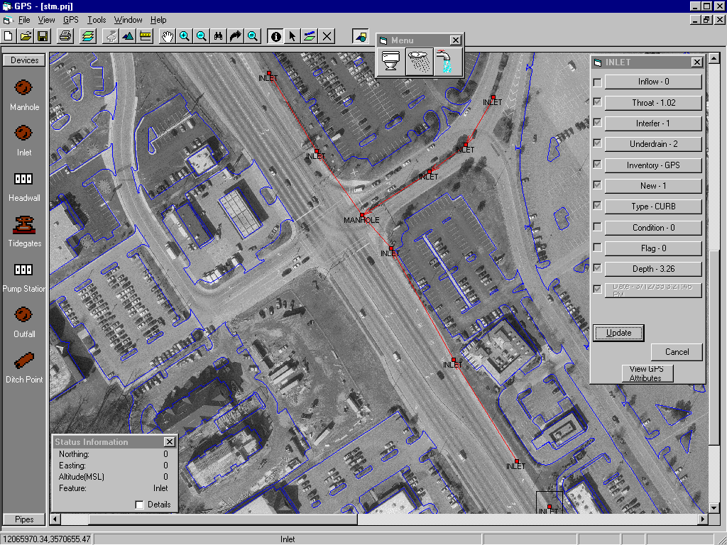
SMARTSurveyor is an easy-to-use and user-configurable global positioning (GPS) software package created for use with Esri MapObjects and Visual Basic within a Microsoft 32-bit Windows environment. It gives field crews the ability to map multiple utility systems during one initial field sweep. Crews can now open a manhole and record the information that’s associated with its — location, condition, and connectivity. Crews locate structures and record associated feature attributes on the spot. Connectivity is built for utility systems with pen-based computers using attribute forms and domain pick lists. Attribute forms record the data about features, and domain pick lists define the attributes for the different structure types. These two features, attribute forms and domain pick lists, are built-in quality control methods to help reduce attribution errors.
SMARTSurveyor paves the way for a holistic approach to building the GIS. Building while in the field has never been done before. Previously, several crews, with no continuity between crews and collection procedures, were needed to build a project. Now, we have an accurate, reliable, and complete method of building a GIS.
Real - Time Differential GPS Positioning
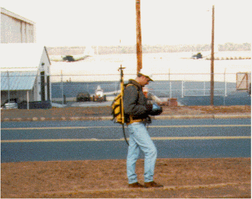
SMARTSurveyor originally provided access to data output from both the Trimble Pro XR and Pro XRS GPS receivers. From these receivers, SMARTSurveyor receives real-time differential (RTD) GPS corrections which provide horizontal positions to within 3 feet accuracy. Vertical positions are also obtained, however, they are only accurate to approximately 5 feet, and therefore are not useful for utility mapping.
SMARTSurveyor uses output from these receivers to update and create GIS data in Esri shapefiles. SMARTSurveyor enables users to collect attribute and positional information simultaneously anywhere on the globe by integrating GPS with the power of Esri MapObjects mapping and data acquisition abilities.
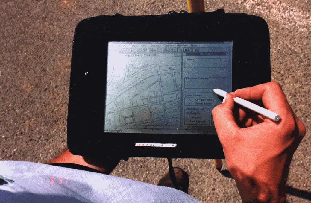
Designed to serve mobile GIS users, SMARTSurveyor can be used on pen-based, laptop, or desktop computers. With SMARTSurveyor, you can access GPS positional information to location positions on a map, add features to a GIS database, collect information on site, check features for accuracy, and edit vector and attribute data. Collected shapefile data can be used directly in other GIS applications, such as Esri’s ArcView, ArcInfo, and Intergraph GeoMedia.
Real - Time Kinematic GPS Positioning
SMARTSurveyor was recently improved to include the use of real-time kinematic (RTK) GPS positioning. RTK GPS positioning allows the user to determine a position to within approximately 0.15 feet (5cm) both horizontal and vertical. Currently SMARTSurveyor is the only software that combines RTK positioning, a graphical interface, and the ability to build utility connectivity in the field.
Other software is available to simply position features using RTK GPS technology along with a graphical interface, however, connectivity is not available. This makes the true difference between a utility inventory survey and a utility mapping survey.
For example, in 1996 Woolpert and Trimble Navigation jointly developed what is now sold as Trimble Aspen-RTK software. This was the first software that allowed a graphical interface that could be used to position features with RTK technology. The graphical interface allowed crews to scan, load, and geo-reference source documents so that crews could see their position on pen-based computers in the field. This ability helped crews locate features, navigate to them, and create a complete utility inventory. This was achievable because with the pen-based graphical interface, crews could digitize a features location when it was not GPS’able. Without this graphical interface, crews cannot inventory a feature when GPS signals are not obtainable. Instead, the features location would have to be recorded on a hard copy plot and then added to a database back in the office. As one can see, the ability to do this in the field saves considerable time and money and improves the quality and integrity of the data being collected.
Conventional Equipment Integration
SMARTSurveyor is currently being enhanced to allow for the integration of conventional survey equipment. Clients who demand accurate positions on all utility features will benefit dramatically from this enhancement.
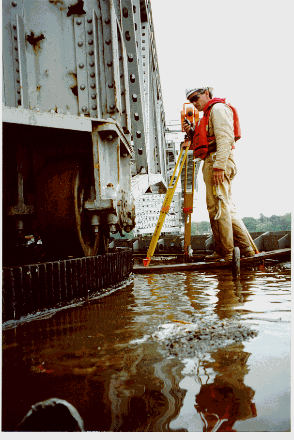
To date, clients wishing to have a utility inventory / mapping survey had a number of options available to them. When conducting a utility survey, between 20% and 50% of the features could be obscured from a GPS position due to trees, tall building, and other obstacles. In these situations, the feature can be digitized to the underlying base map to obtain an approximate coordinate. Depending on the client’s plans for the gathered information, such as storm water modeling, this may not be acceptable since all features may require an accurate elevation. In these circumstances it may be necessary to follow up with a second survey sweep with conventional equipment to obtain an accurate position for these features. This increases the cost significantly, and is sometimes cost prohibitive.
To assist in these situations, Woolpert has begun the integration of conventional survey equipment with SMARTSurveyor. When complete, crews will be able to unplug the attached GPS receiver and plug in a survey total station. By choosing "Total Station" in the tools menu, crews will be able to easily orient their equipment and position obscured features within the same file and within the same software. A typical scenario will be as follows.
The above capabilities will result in saved time and money by eliminating the need for exporting and transferring data between software, and the need for office work prior to using conventional survey equipment to determine the precise position of features.
When performing a utility inventory / mapping survey, it is imperative that QA/QC procedures be built into the survey. Each of the following processes should be developed to ensure that the field data is delivered accurately and completely. The field crews QA procedures can be divided into the following main categories:
The QA procedures during the field collection can be further divided into two main classifications: Operator Procedures; and Software Routines.
The entire QA process starts with the field operator. All other processes were developed to check the work and the information collected by the field operator. It is therefore imperative that they conduct their work in a professional, responsible, and educated manor.
To assist with this, operators are fully trained with all field aspects of the project including software, GPS hardware, measuring procedures, and measuring equipment. They are also educated on the specific utility systems and features to ensure a consistent and accurate database creation.
The SMARTSurveyor software was created with built-in QA procedures to assist with the data collection. It was programmed to incorporate the following QA measures.
The process of building an accurate, reliable utility survey requires thorough planning and an interactive approach to solving real-world problems. SMARTSurveyor alone can’t produce all of the benefits of a utility survey. The consultant and the client need to "partner" together so that the client can realize the benefits of a true GIS that is built in the field. An innovative approach is to involve the client and perform a "test drive" of the data collection process.
A test drive is not a pilot project. A pilot project is usually completed by the GPS/GIS contractor, with results reported later to clients—long after budgets and schedules have been set. Instead, a test drive is the client spending a day or more in the field walking the streets and hunting down utility structures alongside the GPS crew before the scope is finalized. While clients agree there is much benefit to an accurate GIS, they often have varying opinions on what information to collect and what the information means to them. When many people come together on projects of a large scope, there naturally are a number of ideas about what data is needed. And, it is yet another thing for each person involved in the decision-making process to see and know what it takes to collect this data.
While a valve may be clearly outlined on a source document, debris or sediment can keep it hidden unless the street is swept. Participants watch as a crew uses metal detectors, shovels, and picks to find the hidden structures. Often times, structures that are not even located on a source document, or were inaccurately recorded on a source document, are located. If these structures can be found, additional value is added to the inventory—one more capital inventory item is added to the municipality’s financial resources. Other structures, although they’re clearly marked on existing maps, sometimes can’t be found. Analysts and technicians would question the validity of the source documents, yet previous to using SMARTSurveyor technology combined with a test drive, network connectivity was built using these questionable source documents.
A test drive shows the client how it all comes together, tests the project theory before full-scale execution, and immediately shows benefit. By using real-time information, it shows how a GIS can be dynamically built in the field using SMARTSurveyor technology to integrate GPS and survey capabilities into the GIS system and the need for project-specific field procedures. It dramatically improves the chances of success for the GIS.
Building the Project from the Test Drive
A test drive performs two significant functions:
Additionally, the test drive approach answers the questions that nearly all clients pose to define their project. The answers to their questions define the ultimate accuracy and detail needed for the GIS. These questions include:
Unexpected problems are found during the test drive. These problems can include buried manholes and hidden valves. Solutions to previously unknown problems can be found before the full project is executed. And, taking the test drive approach one step further, it produces the work procedures needed to accomplish the inventory. Workflow is defined through a field procedures manual. A field procedures manual can be written and implemented because 90% of the procedures are worked out and learned during the test drive—before the actual project is started.
The test drive is an important planning tool because hidden issues can be addressed before the time and money are spent for the GIS. Officials who participate in the test drive see that the GPS utility inventory is more than simply collecting points. Woolpert recently participated in a project where we learned that RTK GPS wasn’t feasible. The test drive clearly demonstrated why. The area’s dense tree canopy made only 35 percent of the structures GPS-observable with RTK.
Although RTK GPS couldn’t be adopted for that project, there was an immediate benefit: the project scope was refined before losses were realized for both the client and for Woolpert. Issues were resolved before they became problems in the field. Two main issues were:
The test drive provided the catalyst for a group of team members, each with a different background, to resolve these problems.
The test drive determines the amount of effort that’s required to perform the data collection in the field. This in turn can lead to more reliable schedules, and provide flexibility. Because the amount of effort needed to collect the data is realized up front by clients, weekly meetings are necessary for the actual project execution. Collected data is brought into the office and is immediately ready for use, and crews can provide statistical reports of what has been collected in the field. Maps of the data that was occupied and built are provided. Armed with this information on a regular basis, there is room for improving and refining the process on an as-needed basis. Expectations are communicated clearly across the project team and significant goals are set and attained.
The test drive is important for a fundamental reason: to establish and refine the procedures needed to gather inventory data. This in turn helps in defining the scope of the project. While technology is extremely valuable to the collection process and SMARTSurveyor enables crews to record all the data in a single sweep, the data itself could be virtually worthless unless procedures are built and written for the crew to follow. Crews rely on objective criteria for data collection and attribution. By defining the procedures, you have a good base for estimating the hours that are needed to perform the entire project, and scopes are then much more accurately written.
A field procedures manual helps to solve errors of interpretation. For example, what one client called a "B box," Woolpert called a "service valve." It’s easy to see how quickly data can become nearly worthless if differing terms are used to describe the information. To bridge the language gap, photos of each structure type should be taken and reproduced in the manual with appropriate labels so that database references are familiar to all users. Taken a step further, attribution must also be defined. Crews need to be able to quickly pick from a list of pre-defined attributes that are associated with a structure to enforce consistent and reliable data standards. SMARTSurveyor technology provides the ability for project teams to tightly define data terminology and attribution and incorporate this information in the project’s pick lists and attribution lists. When data is input, the crew has no hesitation in entering the data and applying attribution. The chance for errors and inaccurate data is clearly lessened.
Field procedures, however, go beyond data entry standards. Sound field procedures should include everything—from how to record the data in the field, to the uniforms the crews will wear, to explaining the level of effort required in obtaining the data—that is needed to complete the collection process. And, it should stand as a training document for new crew members. Every project member, including project managers, clients, and crew members, know what is expected. There is a set of objective standards. A well written field procedures manual is Woolpert’s bible. It will help the client to maintain and update it’s utility data in the future because how the data is captured and recorded is directly tied to its usefulness and quality.
Creating a field procedures manual causes project managers and the client to think very carefully about the entire process. It helps to identify issues that many times aren’t thought of until a project is in full execution. These issues cover a variety of problems, such as how to attach attributes on-the-fly and in the field to pipes that haven’t been mapped yet.
Woolpert LLP provides dynamic consulting services worldwide to clients who rely on geographic information systems (GIS) and information technology (IT) solutions for government, utility, military, and airport infrastructure management projects. With offices throughout the Midwest, Southeast, and Texas, the firm also offers expertise in environmental engineering, facilities planning and design, photogrammetry, site/civil design, surveying/GPS, transportation, and water resources. For more information, please visit
www.woolpert.comJohn Cestnick, Project Manager
Woolpert LLP
600 Brickell Ave, Suite 801
Miami, Florida, 33131
Phone: 305.358.1565
Fax: 305.358.6564
E-mail: