Abstract: Management of the Delaware Solid Waste Authority’s Northern Solid Waste Management Center - 2, located at the confluence of two shipping channels, requires constant testing and monitoring of instrumentation that records the geotechnical dynamics of the site. A wide range of instrument types allows site managers and consultants to understand these dynamics and plan future solid waste operations economically and safely.
To provide site managers and consultants with this information, customization of ArcView Spatial and 3D Analyst interfaces occurred and MapObjectsÔ applications were developed and linked to an MSAccessÔ database containing tens of thousands of measurements taken from over 300 different instruments over nearly 20 years. Users of the system can now query, view, analyze and report on variables related to stability and movement of the landfill in four dimensions; the fourth dimension being time.
Site Conditions: The Northern Solid Waste Management Center, NSWMC-2 is located at Cherry Island, Wilmington, Delaware. This facility is owned and operated by the Delaware Solid Waste Authority (DSWA). The 323 acre landfill property is bordered by the Wilmington Sewage Treatment Plant to the north, the Delaware River to the east, the Christina River and the dredge ponds of the United States Army Corps of Engineers to the south, and Interstate 495 to the west. The facility is currently used as a waste management center and contains four active municipal solid waste Municipal Solid Waste (MSW) disposal areas, Phase IA and Phases III through V. The MSW is being filled over a soft silt placed by hydraulic filling methods. Barriers between and around the perimeter of the phases consist of dikes constructed from either desiccated hydraulic fill or flyask stabilized sludge. Due to the soft foundation soils, portions of the facility have included the use of geosynthetic reinforcement material and wick drain fields to facilitate construction.
There is a substantial amount of subsurface information available about this site including: design reports, slope stability studies, instrumentation monitoring reports, and operation reports. The available data consists of about 180 soil test borings, in situ test data, laboratory test data and about 300 geotechnical instruments including: inclinometers, piezometers, total pressure cells, thermistors, and settlement plates. Historically, numerous consultants have gathered the data for this site. Currently there is a program of instrumentation monitoring on monthly and quarterly cycles where the data are collated and submitted in written report form.
As a separate record keeping process, the DSWA personnel and the operating contractor are maintaining records of the areas and volumes of MSW placement.
The instrumentation data is collected to provide the DSWA and consultants with indications of the performance of the facility. These data can then be correlated with the design assumptions to confirm acceptable performance of the facility. Given the history of the data collection, thorough review of the information has become cumbersome. Furthermore, correlation of site response data with filling activities at the time of the reading is very difficult. As the operation continues, additional consultants and designers will be taking over the evaluation. The DSWA desired a system that would facilitate the ongoing data management and interpretation as well as the ability to make all of the site data readily available to new consultants during the entire operating life of the landfill which could range from seven to twenty-five or more years.
System Overview: Three sets of components were developed for the DSWA’s Cherry Island Geotechnical Information System. The first major component in the overall system is a relational database management system (RDBMS) in MSAccessÔ format. The second major component is a geographic information system (GIS) in Esri’s ArcViewÔ format. The third component consists of two separate Visual BasicÔ applications developed using MapObjectsÔ controls for retrieval and reporting of piezometer or settlement plate information.
Data: Directory Structure: The structure of the data is critical at several levels. First, a logical approach aids the user in finding the desired information. Second, by adhering to a consistent structure, a more intuitive approach to storing data is applied that limits the risk of randomly saved files and lost data. Third, consistency in the data structure facilitates standardization and reuse of the interface forms.
The directory structure was set up with five main subdirectories under the root directory of /DSWA_GIS.
Table 1
Basic Data Directory Structure
Subdirectory |
Use |
| /Instment | Contains subdirectories for all instrument related information including databases, images, shape files (2D &3D) and surface coverages. |
| /Ops | Contains the database and related GIS files for the operations filling data. These include lift placement and unit weight measurements. |
| /Programs | Contains the Settlement Plate and Piezometer Query applications as well as a subdirectory for the scripts utilized in ArcView™. |
| /Projects | Contains the project files used by ArcView™. |
| /Sitedata | Contains general site data such as property boundaries, CADD files, quad sheet images, etc. |
| /Userhelp | Contains the user guide and related readme or metadata files. |
The third standardized subdirectory level would include each instrument type where the fourth level of directories is again consistent and includes:
| /Database | |
| /Images | |
| /ShapFile | |
| /2DShape | |
| /3DShape | |
| /Surfaces |
Where data sets do not fit easily into this structure, the standard third and fourth subdirectory levels are structured to reflect their contents appropriately. For instance, data sets mapped at a regional extent such as DEM’s, aerial photos or USGS quad sheets are contained in subdirectories under the Sitedata directory and are named accordingly (DEM, Images, etc.).
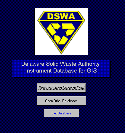
Introduction: The relational database management system (RDBMS) for this project is an integrated system of modules (or separate yet similar databases). The image below shows the start up screen and program interface that provides access to the overall RDBMS.
Figure 1: RDBMS Opening Screen
The images below show the primary interface dialogs that launch each of the individual components in the RDBMS.
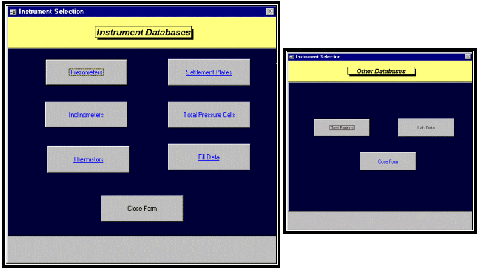
Figure 2: Database Module Selection Screens
Each of the buttons shown above provides access to geotechnical information contained in its respective database module. In general, the functions provided in each of the separate databases include forms for data entry, adding instruments, instrument maintenance and viewing existing data.
Database Structure: Access to all of the data is handled through the interface menu. This provides easy access as well as security and data checking. The data for each instrument, as well as items such as facility operations information, laboratory and stratigraphy, is stored in separate databases. This was done to limit the size of each database module, facilitate management of the information, limit unnecessary access to the data for security purposes, and limit the impact of data loss should a file become corrupted.
Within each database, the data is broken down into several levels. Table 2 shows the general format.
Table 2
General Database Table Structure
Structure |
Purpose |
| Index | Fixed information such as ID, location, and historic reference names. |
| Installation | Relevant data regarding instrument type, date of installation, elevation when installed. (In some cases, this information is stored as a record in the Maintenance table.) |
| Maintenance | Information related to modifications of an instrument, general observations, or problems encountered. |
| Data | This table is generally limited to the date of the readings and the actual final reading. In most cases, this stores final data such as piezometric level, not raw field data such as depth below top of well casing. |
Relational Database Operations: The relational database was designed to store information in multiple MSAccess™ database files. Retrieval is available either through the use of the forms provided in each database file or through ArcView™ GIS. Figure 3a shows the general format followed, wherever possible, in creation of the databases.
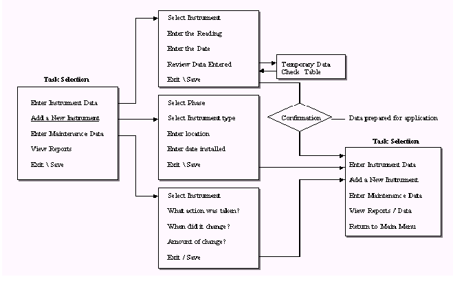
Figure 3: Database Development Flow Diagram
Main Task Selection Screen: Each database contains a startup screen containing several buttons that will access the appropriate functionality within the database. This screen is displayed when the database is opened.
Using the main database, interface from Figure 2, a database is selected. Using the Piezometer database as an example, the Startup form is shown below.
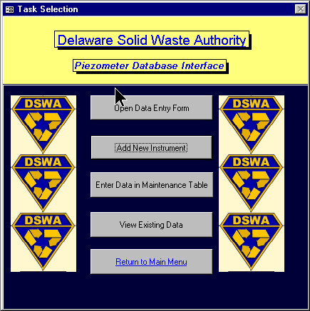
Figure 4: Database Startup Screen
The tasks available include: Open Data Entry Form; Add New Instrument; Enter Data in Maintenance Table; View Existing Data; and Return to Main Menu.
Entering Data for Field Instruments: Selecting Open Data Entry Form will open the screen as shown below. The first step is to select the instrument for which data will be entered. A combo box listing available instruments as contained in the master Index table is provided for reference.
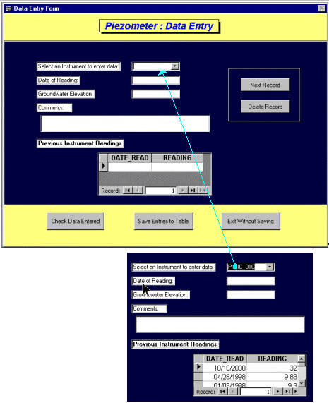
Figure 5: Data Entry Form
Once an instrument is selected, the Previous Instrument Reading list box is updated with the historic data. This provides the user a ready comparison check to further ensure that the data being entered is representative and accurate.
Upon completion of data entry, the Check Data Entered button can be selected. This will allow the user to view a temporary data table before the work session is permanently added to the main database. Within this table view, the data can be manipulated directly until the information is exactly what the user intended. The Save Entries to Table button will take the information in the temporary table and append it to the main data table for permanent storage.
Adding a New Instrument: This task is selected when a new instrument has been installed on the site. This is where all the essential information related to an instrument is entered into the database. It is important that this information be entered correctly and in the proper format.
The Add New Instrument screen is shown below.
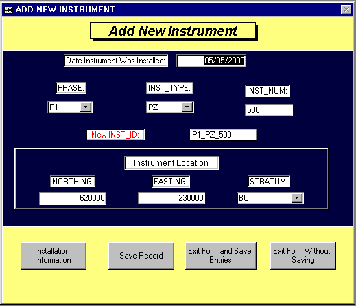
Figure 6: New Instrument Form
Adding a new instrument begins with establishing a reference name. The RDBMS has been structured to use a consistent format for naming across the system. This system includes the Phase in which the instrument is located, the instrument type and a reference number. This facilitates locating a particular instrument.
To ensure that this system of naming is maintained, each component of the name is required to be entered individually then the name is automatically generated. Indexing within the table ensures unique names. The resulting "Inst_ID" is used throughout all of the database tables.
Instrument Maintenance: Each instrument database includes a table for maintenance data. This can range from cleaning operations, extending the top of the instrument, abandoning, or general comments on the conditions of the instrument at the time a reading was taken. Figure 7 shows an example form.
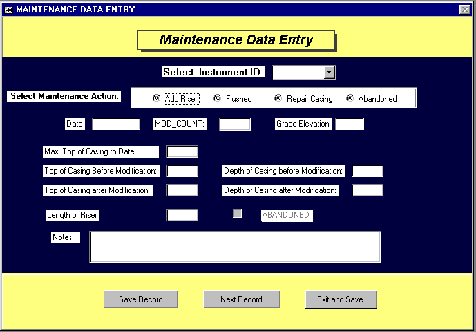
Figure 7: Maintenance Data Form
Functionality particular to the maintenance type is incorporated so that relevant data is collected. Similar data checking and saving functionality are also included in this form.
Existing Data Reporting: This function allows a quick review of all of the readings and maintenance data related to a selected instrument.
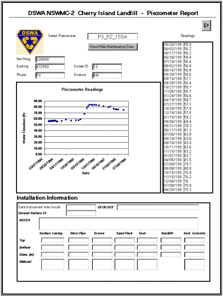
Figure 8: Instrument Data History Report Form
General: Most of the database modules function in this manner. Each has data access and reporting functionality. The test boring and laboratory modules are structured differently so that the applicable data can be viewed in an appropriate format. These two databases are also not utilized by the DSWA as often as the instrument databases and, as such, are accessed through the Open Other Database button on the main start up screen. Figures 9 and 10 show the general layout for these database forms.
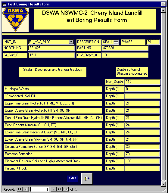
Figure 9: Test Boring Strata Form
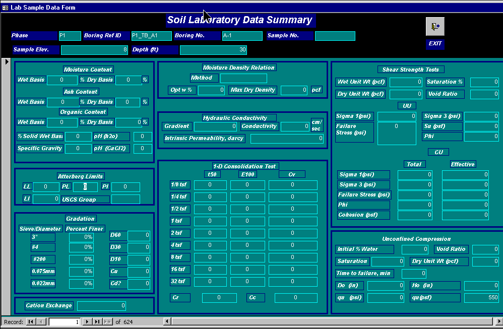
Figure 10: Laboratory Data Report Form
Inclinometer Data: Although structured similarly to the other databases in this system, the inclinometer database contains a vast amount of information that does not fit neatly into the forms described above. As such, this database has features that warrant and require further explanation. An inclinometer records lateral deflections of a vertical casing (similar to a water well). These readings are obtained as deflections of the casing in two orthogonal directions. Readings are taken at two foot depth intervals. Thus, for each reading, there are 100 pieces of data in a 100 ft long inclinometer casing. This made visualization of the nearly 50,000 data points within the database and in the GIS system challenging. Figure 11 shows the resulting table structure for this database module.
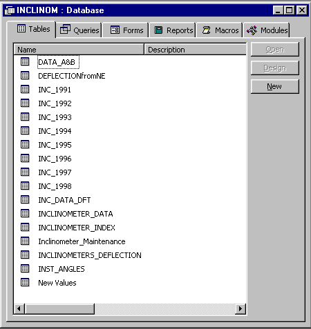
Figure 11: Inclinometer Module Data Table List
The Inclinometer_Data table contains the raw data imported from the inclinometer data acquisition device. Processing of this information through several queries as discussed below is required before the final data table containing converted information suitable for plotting gross movement in the GIS system is completed within the Inclinometer_Deflection table. Through the use of queries, the remaining tables are created and generally consist of intermediate steps in the data development process. The Inc_year (i.e., INC_1991) tables are created for storage of the information in a more manageable size.
Inclinometer Data Conversion: The field measurements are downloaded from the field datalogger into software developed by the Slope Indicator Company, the manufacturer of the inclinometer equipment. This software utilizes a proprietary data structure for storage and interpretation of the data. For use in the DSWA GIS system, this information had to be converted to ASCII format, then manipulated into a usable format for appending to the Inclinometer_Data table.
Once the ASCII data is converted using a spreadsheet to a format consistent with the database tables, the information can be cut from the spreadsheet and using Edit-Paste Append, the data is added to the Inclinometer_Data table in MSAccess™.
The data imported from the field readings consists of depth, date, A Reading and B Reading (two orthogonal directions). This information is not suitable for direct interpretation of net movement of the instrument casing nor plotting in the GIS system. In order to manipulate this information further, several queries were developed to step through the conversion process. Figure 12 contains a list of the queries contained in the database.
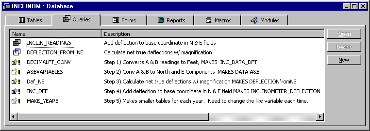
Figure 12: Inclinometer Queries used for Data Conversion
The description of the query gives an indication of the process required to convert the raw inclinometer data appended to the Inclinometer_data table into the useful Inclinometer_deflection format.
Introduction: The geographic information system (GIS) supports map-based or graphic viewing for most of the data contained in the RDBMS. Several different viewing windows have been set up to display the location of, and spatial relationships between, geotechnical monitoring equipment in and around the landfill. Each of the view windows relates to a specific instrument type or a discrete aspect of the landfill operation. While the existing views have been preset, the User can also create and save additional views to overlay and compare information based on different instrument types. Alternatively, they can add data sets to the current views to provide immediate information about how readings from one instrument type or feature might be impacting readings from other instruments or the overall condition of the site.
GIS Project Structure: The views developed in the GIS were identified by the Authority as those which would relate best to existing monitoring equipment and which would support current procedures utilized by the Authority and their consultants in managing the landfill.
Data content in the GIS can be divided into two primary types. These include two-dimensional (2D) data sets and three-dimensional (3D) data sets. Figure 13 show the list of 2D views and 3D scenes that are contained in the base GIS data project.
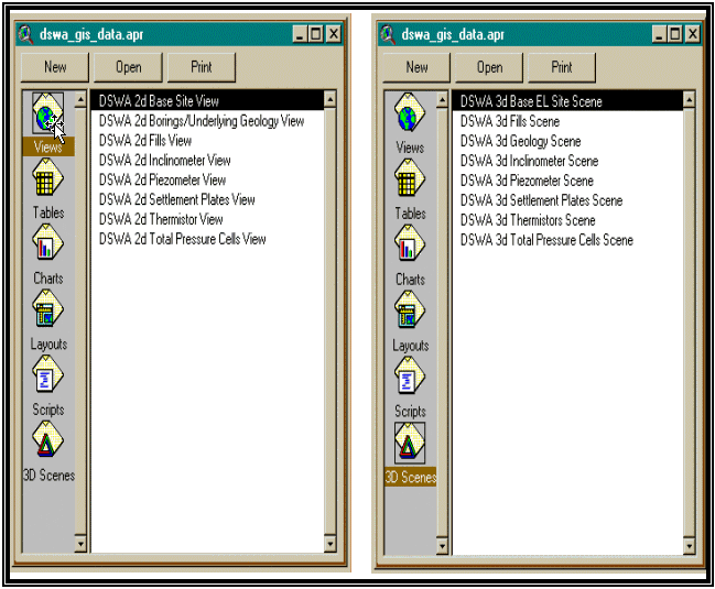
Figure 13: Base Project Views and Scenes
Each of the 2D Views and 3D Scenes shown above provides access to geotechnical and operational information in combined mapping and tabular format.
GIS Operations: A base ArcView™ project was developed that contains Views and 3D Scenes related to each of the databases as well as general site features. The project does not load all of the shape files, images or databases that were developed but does show representative shape files, etc. This allows the new user to get an idea of what the data looks like, how to set up legends and how to compare data. Additional shape files or other information can be added to a View or copied from one View to another for comparison. The opening View provides an overview of the site as shown below.

Figure 14: Opening View, General Site Overview
Sticking with the piezometer data as an example of the functionality within this system, the following details some of the capacity within the system.
Each instrument View contains an index shape file showing the location of all instruments of that type at the site. The View then contains relevant example data; in this case, readings from the first quarter of 1998. Since the piezometer readings recorded at this site are representative of several piezometric levels and are intended to record the direction of seepage during consolidation of the underlying soft soils, several strata must be isolated. Figure 15 shows the basic view of piezometer locations screened within the upper hydraulic fill piezometric stratum as well as a representative variety of shape files available to depict the remaining piezometric surfaces. This view also shows how the areas of filling completed to date are also included with the instrument readings so that correlations can be drawn between piezometer and operations data.
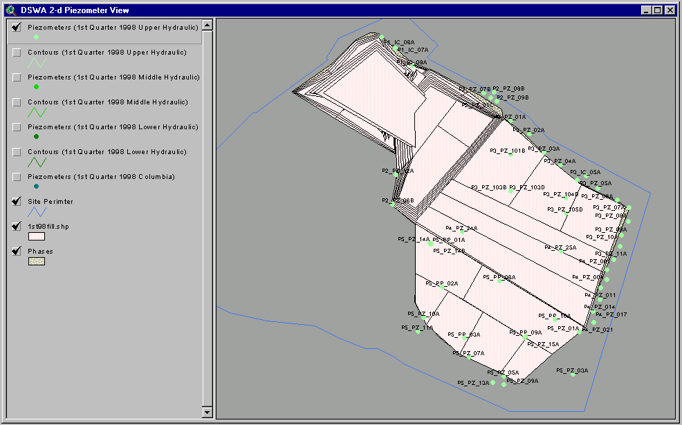
Figure 15: Piezometer View
Using auto labeling, the data points can include the instrument ID, readings or any other information contained in the RDBMS. Using Spatial Analyst™, the contouring of the data readings was also completed on representative data sets to confirm anticipated trends or identify anomalies.
Capitolizing on the strength and flexibility of this system allows the correlation not only of a single instrument with the fill data, but also with other instruments in the system. Questions such as whether the maximum settlements are occurring in the areas of most significant pore pressure dissipation or whether lateral deflections recorded by the inclinometers are related to elevated piezometer readings can be evaluated quickly.
When this information is extended to the third dimension, the ability of the user to understand this vast data set is enhanced significantly. Figure 16 shows this same piezometer data set extended to 3D which allows the clear visualization of the fill height, as well as the piezometer locations and the relative piezometric level beneath the fill areas. Where the piezometric level (water pressure) exceeds the height of the MSW fill, the contours appear above the fill lift polygons.
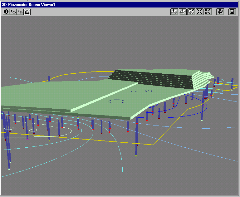
Figure 16: Piezometer 3D Scene
Of even more significance is the ability to visualize the inclinometer data on a site wide level. Where the data is limited to paper report formats, visualization of more than one instrument at a time is difficult. Furthermore, spatial relevance of the plot on a piece of paper is even more esoteric. When the entire history of the inclinometer data set becomes available in one location, 2D representation of a selection from the data set can be visualized across the site as shown below. In this image, the inclinometer readings from the northeast corner of the site are shown for the year 1997. The legend was set to use the Date_Read field as a Unique Value when selecting colors for the symbols. It is easy to see where movements were concentrated.
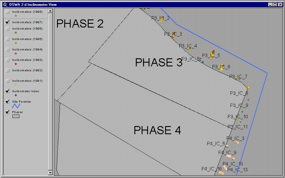
Figure 17: Inclinometer View of NE Corner of the Site
Extending this same image again to 3D allows even more understanding of the site conditions.
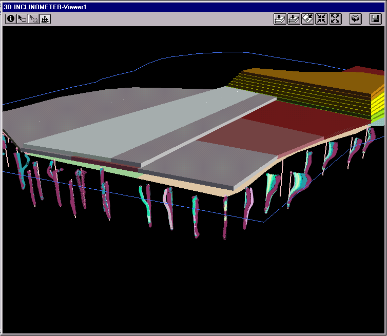
Figure 18: Inclinometer 3D Scene of NE Corner of the Site
Introduction: Two separate MapObjectsÔ applications were developed for retrieval and reporting Piezometer and Settlement Plate readings. These two types of data generally have the largest volume of information and are most often accessed by the consultants. The applications are each individual geographic information systems. They each support map-based or graphic viewing and retrieve data directly from the RDBMS.
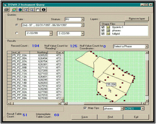
Figure 19: MapObjects™ Piezometer Application
Data Inputs: In each of the applications a single map viewing window is provided that displays the location of, and spatial relationships between, piezometers or settlement plates in and around the landfill. The applications are designed to simplify the query process for users such that readings can be selected for a specific set of instruments for a given date range. Data that is queried and retrieved can be reviewed and discarded or it can be saved as a discrete data set (shape file) and later imported into the ArcViewÔ for analysis with other existing data layers.
Operations: Base-map features shown in the view include the landfill phase boundaries to orient the query results. A tabular listing of instrument readings is also displayed beside the map window. This tabular listing provides the instruments' ID, northing, easting, stratum (for piezometers only), date of the reading and the reading itself. The application also provides the user with information related to the number of instruments that is included in the selections set for the date range specified. Since many of the instruments are read more often than typically selected in a date range query, the final data set is culled and only the most recent reading within the desired date range is saved in the data set. The image below shows the layout and functions available in the Piezometer Application.
As the system was nearing completion, the implementation was performed in two phases. First, the beta package was delivered and installed at the site for use by the on-site personnel on a casual basis. Limited training and explanation were provided at this time. Once the system was essentially fully functional, a two day training class was provided to the Authority’s personnel and a representative of the current data collection consultant. This seminar focused on the basic training of MSAccess™ and ArcView™ with a focus on the specific use of the RDBMS and the GIS Project developed.
The Authority is now utilizing the system to support their operations and its current instrumentation-monitoring consultant is inputting recently collected data. Obviously as the system use expands, the data quality and coverage will improve. Although the system is now working to serve the intended functions of providing access and tools for interpreting historic information, numerous enhancements are already anticipated.
Some of the first improvements will likely be related to automation of data input. The current system is designed to maximize data confirmation and security during data entry. The current instrumentation consultant uses spreadsheet systems to reduce the field readings. It is likely that automated conversion methods will be added to directly transfer data from the spreadsheet format to the protected data tables. Another key enhancement will be the automated conversion of data directly from inclinometer data recorders. This could also be extend in the future to automated instrumentation monitoring (data loggers) and direct input into this system.
Additional enhancements will also include automated reporting of the individual data sets obtained from a monthly or quarterly reading cycle. Standard reporting and summary of these data sets is required for permit conformance and agency review.
A key interest of the Authority is to eventually extend this system to an Intranet or Internet based system for access by all of their internal personnel as well as the external consultants involved in data collection, management, and utilization for current and future design efforts. The use of a web-based system will ensure a single consistent data set providing up to date information to all users.
AUTHOR INFORMATION
Primary Author:
Scott Todd, ASLA
Pennoni Associates, Inc.
3001 Market Street
Philadelphia, PA 19104
215-222-3000 phone
215-222-3588 fax
stodd@pennoni.com
Secondary Author:
Allen Cadden, P.E
Schnabel Engineering Associates, Inc.
510 East Gay Street
West Chester, PA 19380
610-696-6066 phone
610-696-7771 fax
acadden@schnabel-eng.com
Richard Watson, P.E.
Delaware
Solid Waste Authority
P.O. Box 455
1128 South Bradford Street
Dover, DE 19903-0455
302-739-5361 phone
302-739-4287 fax
rpw@dswa.com