The U.S. Bureau of Reclamation in cooperation with the California Department of Pesticide Regulation, County of Yolo Department of Agriculture, and California Department of Water Resources, is beginning a project to create GIS agricultural field-boundary databases throughout California. The first database will be created with the County of Yolo Department of Agriculture.
The relational database will allow a variety of users to share field-level land use information such as pesticide applications and current land use categories. The database will also enhance applications such as remote-sensed-based change detection in and adjacent to agricultural areas, and analysis of the agricultural and urban interface.
Jeff Milliken, Mariette Shin, Rosemary Neal
I. Introduction
Various State and Federal agencies in California involved in tracking and monitoring California agricultural land use have recently taken steps towards improving the standardization and quality of their data collection, storage, and processing methods. In this era of improved cooperation between government agencies, efforts to standardize agricultural land use data to prevent data duplication, ease data exchange and expand the realm of applied geographic analyses are being implemented through cooperative projects.
II. State Agency Needs
The California Department of Pesticide Regulation (CDPR) began its full use reporting program in 1990 in response to concerns regarding insufficient detailed pesticide application information to use in determining potential human health risks from pesticide exposure to workers and residents. Reports must include the date and location of application, (section, township and range) details on the kind and amount of pesticides used, and the crops upon which pesticides are applied. In addition, all post-harvest pesticide treatments of agricultural commodities must be reported. CDPR is responsible for evaluating and registering all pesticides before sale or use in California, as well as for regulating and controlling the use of pesticides.
Under the direction and supervision of CDPR, county agricultural commissioners (CACs), such as County of Yolo Department of Agriculture (CYDA), are required to carry out local enforcement activities. In addition to administering the restricted materials permitting system, the CACs enforce other state laws and regulations relating to pesticide use at the local level. The CYDA may require that restricted material users employ specific use practices to mitigate potential adverse effects, or may deny the permit with cause. Permits for the agricultural use of these pesticides must be specific as to location and timing of applications and are usually issued for a season or year. Before applying the pesticide, growers must submit a notice of intent to CYDA at least 24 hours before the application. It must include any changes in the environmental setting, which may have occurred since the permit was originally issued.
In the mid-1980's, CDPR developed software to assist Yolo and other counties in issuing permits and in managing the restricted materials permitting system. Among other items, these programs capture information pertaining to the permit holder, site identification number and location description, commodity/crop information including the proposed planted acreage, the application method, the total amount of product applied, the date and time of application and a list of chemicals which may be used throughout the year for each commodity/crop. Until recently, the only geographic information captured was the section, township and range, base and meridian in which the location for the permit was issued, and paper maps of site locations.
Currently, the only true geographic component of pesticide use data is the identity of the square-mile section in which the applications are made. While this allows for the evaluation of pesticide use activity within the square mile, very limited information is provided as to the proximity of pesticide applications to sensitive locations such as schools, urban development, natural vegetation and surface water bodies. In addition, because of the spatially vague nature of the data, it is often impossible to distinguish from the pesticide use reports the exact number of treatments made to a particular agricultural field. This can lead to significant calculation error in exposure estimates related to human and ecological health. Any changes to agricultural land use would also be difficult to track, given this methodology of documenting use locations.
III. Federal Agency Needs
Crop data and water use information is required for water contracts under the Central Valley Project Improvement Act (CVPIA). Remote sensing and GIS can offer cost-effective means of providing more frequent crop/land cover data for short and long-term planning, and be used to calculate crop water consumption. Accurate crop identification is an essential part of this process, since crop evapotranspiration and acreage are important parameters in these equations that vary by vegetation type.
The U.S. Bureau of Reclamation (USBOR) has recently begun collecting Central Valley crop data to be used in conjunction with remote sensing and GIS. The improved specificity of crop delineation in a revised field-boundary database will allow for greater accuracy in crop and water use calculations in these areas.
The revised field-boundary databases will also be important to current USBOR and U.S. Fish and Wildlife (USFWS) change detection programs being implemented to track and monitor habitat changes in the Central Valley of California.
IV. Revised Field-Boundary Databases
To address the issue of site-specificity, individual CACs have begun to develop "field-boundary databases", independently of CDPR. The field-boundary databases that are being developed represent the boundaries of permitted agricultural field sites, which must be uniquely identified by a combination of the permit holder's identification number and the individual site/field identification number. To maintain statewide consistency, CDPR sponsors a developers group populated with representatives from a geographically and agriculturally diverse range of California counties. This group addresses a number of issues surrounding the development of standardized field-boundary databases, including the improvement of data quality and ongoing maintenance concerns.
The California Department of Water Resources (CDWR) has been developing digital land use databases by county for several years. These databases are updated approximately every five years and agricultural boundaries are defined by crop types present and do not necessarily delineate field boundaries based on discrete borders or permit information. However, these databases offer an excellent foundation to build upon. Arcs and polygons are being edited and added to capture the level of specificity required to meet a variety of multi-agency needs.
V. The Cooperative Project With County of Yolo Department of Agriculture
The USBOR Mid-Pacific Region, in cooperation with CYDA, CDWR and CDPR, has developed a draft field-boundary database coverage for Yolo County that defines all discrete agricultural fields. The field boundaries were created by on-the-fly digitizing in ArcEdit over 4 meter pixel resolution aerial imagery supplied by CDWR in State Plane projection, and were appended to CDWRs existing 1997 Yolo County land use database. The coverage was then converted to a shapefile for CYDA to modify and attribute based on county agricultural permit information.
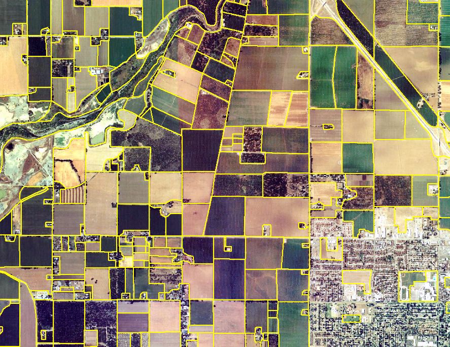
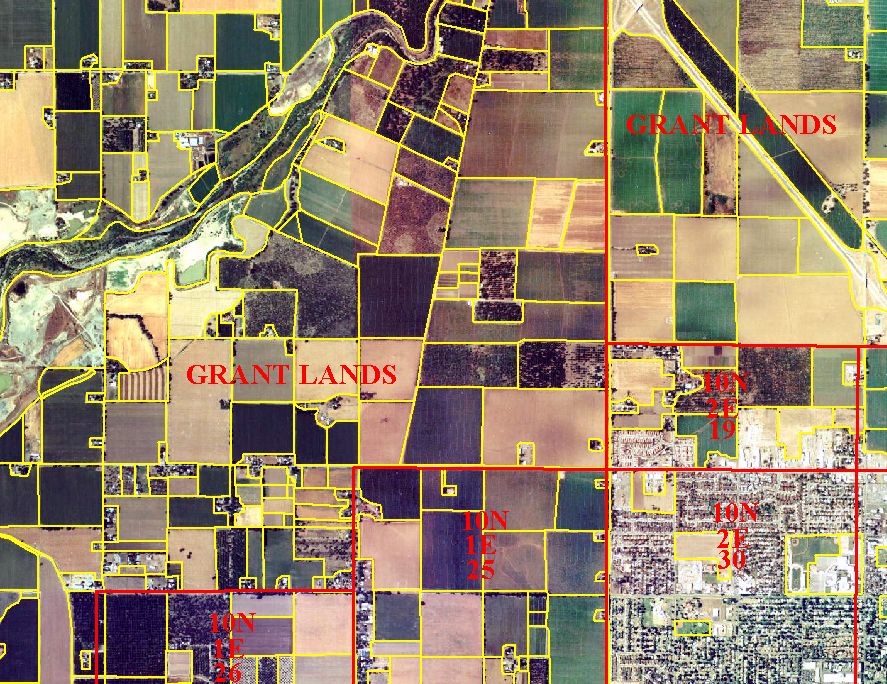
An example of the revised GIS field boundary coverage over CDWR aerial imagery is presented in Figure 1. For comparison's sake, township, range and section borders are displayed over the revised field boundary coverage in Figure 2. By viewing these figures, one can see that point locations identified solely by section may not be sufficient to describe environmental changes to a discrete field, nor allow any conclusions to be made regarding pesticide exposure to sensitive populations.
The use of high-quality, high-resolution orthorectified aerial imagery allowed for accurate placement of digitized field boundaries. The revised field boundary locations can be verified and updated using a variety of available satellite imagery. Additional boundaries were also added around urban, residential, and riparian areas, which will allow for increased accuracy in generating land use acreage figures and depicting current land use conditions in the landscape. At this time, many farm roads are depicted as single line features. Roads will be more accurately digitized as time and funding allow.
The CYDA is currently in the process of completing a year 2000 pesticide application database. CYDA has been using ArcView (Version 3.1) to create a point coverage. CYDA is adding their point locations using the USBOR's revised field boundary coverage as a backdrop to confirm and QA/QC field boundaries as new permit information is entered. CYDA plans to edit the field boundary shapefile as errors are encountered.
In addition to pesticide type, location, volume and concentration, the CYDA database also includes data on crop type, and date and time of pesticide application. Upon completion of the year 2000 pesticide point coverage, an "identity" will be run with the revised field-boundary database to merge all field data from both agencies. The advantages of partnering up with CYDA, CDWR and CDPR include verification of consistency in inter-agency crop identification data, improved pesticide application locations and crop acreage data, and the creation of a standardized and complete field-boundary database that can be shared with other state, federal and local agencies.
VI. Conclusions
This project offers the potential for standardized agricultural databases that can be cooperatively maintained and updated. Attributes specific to each agency can be linked to the database as well as easily shared with other entities. As commissioners from other California counties have seen the enormous potential of using field-specific geographic data as part of their pesticide regulatory programs, the enthusiasm for utilizing a GIS system and developing a field-boundary database has grown from a handful of CACs in 1996 to more than a third of the state. Most of the outlay required for the implementation of a GIS and development of field-boundary databases has, and continues to be, borne by the CACs. Collaborative efforts involving other state and federal organizations, such as the cooperative project between the CYDA, the USBOR, the CDWR and CDPR, provide ways in which the burden of data generation and development can be shared, and duplication of effort reduced.
VII. Acknowledgments
The authors would like to thank Amy DelBondio and Laurie Schuler-Flynn of the County of Yolo Department of Agriculture, Lower Colorado and Mid Pacific Regions of the Bureau of Reclamation, and Tom Hawkins and Austine Eke of the California Department of Water Resources for support of this project.
VIII. Appendix
Figures
Figure 1. Draft Yolo County Field Boundary Coverage over CDWR Aerial Imagery
Figure 2. Township, Range and Section Lines over Revised Field Boundary Coverage
J. Milliken and M. Shin
U.S. Bureau of Reclamation
2800 Cottage Way, Sacramento, CA 95825
R. Neal
Pesticide Enforcement Branch
California Department of Pesticide Regulation
830 K Street, Sacramento, CA 95814