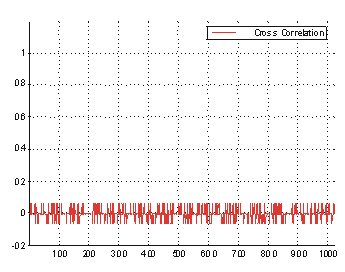
Figure 1. Cross-correlation: PRN 19 and PRN 25
Genetic Algorithm, Global Positioning System (GPS), Event Management, P-25
Automated Monitoring Control International, Inc. (AMCI) recently completed a project involving the use of GPS signals to automatically control the channel or mode selection of a mobile radio. The AMCI system uses GPS location data and stored data of simplified radio coverage areas to control the mobile radio channel selection. This system is being installed on Amtrak locomotives in the Pacific Northwest as part of a railroad industry pilot test of a new radio communications technology called APCO Project 25. The pilot is funded by the Oregon Department of Transportation (ODOT), the Federal Railroad Administration (FRA), and Union Pacific Railroad.
This paper reviews the need for this new mobile radio technology and then describes the operation of the key components of the system developed to control the mobile radio channel selection. The radio channel selection system involves two separate processes:
AMCI uses Esri ArcView and ArcInfo to manage Geographic Information System (GIS) data related to the ODOT test. These products are used specifically to determine the coordinates of the roads and railroad track, to view the results of radio performance predictions, and to visualize the results of the radio testing.
Finally, the paper includes a brief overview of the equipment being deployed on Amtrak locomotives to test data radio communications based on the APCO Project 25 standard.
Reliable radio communications is very important to the normal operation of today's railroads. FRA regulations mandate railroad dispatchers and conductors maintain radio contact. To comply with FRA regulations today, locomotives are equipped with 99 channel Very High Frequency (VHF) radios that operate near 160 MHz.
Recently, the Federal Communications Commission (FCC) initiated a process called refarming which is intended to improve the utilization of the radio spectrum below 800 MHz. Refarming refers to changing equipment requirements and reallocation of radio spectrum to encourage more efficient utilization. Refarming is making technical changes to harvest additional communications capacity from within portions of the radio spectrum that were previously considered fully occupied. Since the FCC refarming initiative includes the VHF 160 MHz radio spectrum, the rail industry has been seeking more spectrally efficient radio technologies in order to comply with refarming requirements.
Railroads also expect to use radio communications to improve speed and safety. In order to increase the speed of passenger trains and operate a mixture of freight and passenger trains in a corridor, an improved safety system such as Positive Train Separation (PTS) is needed. The PTS concept is based on data communications via radio between a dispatch center and enforcement equipment on the locomotive. The enforcement equipment is configured to apply the locomotive's brakes unless confirmation messages are received from the dispatch center at predetermined intervals. Rail industry initiatives for PTS need a long-range wireless communications platform.
An available standard for VHF voice and data radio is called APCO Project 25. This standard was developed by the Association of Public Safety Communications Officials (APCO) and is being considered by the railroad industry as a solution for refarming the railroad VHF spectrum.
APCO Project 25 refers to equipment based on a family of standards and bulletins published by the Telecommunications Industry Association. These standards define, describe, and otherwise document APCO Project 25 system and equipment requirements necessary for system interoperability and compatibility. APCO Project 25 systems generally provide digital land mobile radio services for private radio communications systems and more specifically such services for local, state, and national public safety organizations and agencies. These standards and bulletins provide for communications between and within various APCO Project 25 (P-25) systems and system elements.
The rail industry has discussed the P-25 standard at great length but has used it on a very limited basis. In order to validate the selection of P-25 for rail applications, a pilot test was initiated. The ODOT P-25 Pilot Project is an evaluation of the P-25 radio technology that will determine its real performance in a railroad application and see if the potential benefits of this technology can be demonstrated in a typical railroad application. This pilot will also evaluate P-25 as a platform for PTS communications. P-25 equipment from Motorola was selected for the Pilot Project.
The Motorola implementation of an APCO-25 Integrated Voice and Data system is designed to provide voice and data coverage over a number of non-interfering sites. Sites can be made non-interfering by putting adjoining or overlapping sites on different frequencies (called multiple single site configuration) or by adding simulcast hardware to the sites to provide a common frequency usage for a set of sites (called a single simulcast site).
Motorola recommended using one or more simulcast sites for this project to ensure that overlapping sites operate on different RF frequencies and/or Network Access Codes (NACs). Because of the cost of a simulcast system, the decision was made to utilize multiple single sites with different frequencies and/or NACs arranged in a non-interfering pattern. That decision forces the mobiles, in this case locomotives, to change modes as they move down the track in order to stay in contact with the ground network. These changes have to be made each time the radio moves from one site's coverage to the next, much more often than the current radios require. (Currently railroads install a number of base stations on a common RF frequency along a section of track.) In order to prevent the users from having to manually change the radio modes as the trains move, AMCI developed a system that will keep track of the train's position and automatically set the radio to a mode that has been predetermined to work in that area.
The AMCI system relies on two fundamental elements: Determining locomotive location using GPS and forecasting radio coverage areas. By using GPS location reporting and known radio coverage areas, the AMCI system recognizes when the train enters new coverage and automatically changes the radio frequency to the new base station coverage. If the train passes out of all known radio coverage areas, the system sets the radio to a mode in which data transmission is inhibited.
Automatic control of channel selection is based on determining the locomotive location using GPS. Operation of GPS is described in the next section.
Originally developed by the Department of Defense as a military system, GPS has become a global utility. GPS is a dual-use system, providing highly accurate positioning and timing data for both military and civilian users. There are more than 4 million GPS users worldwide.
The GPS system is comprised of three segments: a control segment, a space segment, and a user segment.
A GPS receiver uses signals received from a minimum of four satellites to calculate the receiver's position. Each satellite in the GPS constellation continuously broadcasts on two frequencies (referred to as the L1 and L2 frequencies). GPS provides two different levels of service, the Standard Positioning Service (SPS) and the Precise Positioning Service (PPS).
Signals transmitted by each satellite are modulated by three data streams. The GPS ranging signal refers to the clear acquisition (C/A) signal, sometimes called the coarse acquisition signal, broadcast by the GPS satellites. The C/A signal is transmitted on the L1 frequency along with the precise (P) code.
The C/A signal consists of a carrier wave modulated with pseudo-random noise (PRN) that is superimposed with the navigation message.
| Ranging Signal Term | Acronym | A.K.A. |
|---|---|---|
| Clear Acquistion Signal | C/A | Coarse Acquistion Signal |
| Pseudo-Random Noise | PRN | Gold Code |
| Precise Code | P | Protected Code |
| Encrypted P Code | Y | Anti-Spoof (AS) Code |
| Precise/Encrypted Code | P/Y | - - - - |
Table 1. GPS Ranging Signal Terms
GPS receivers generate replica copies of the well-known PRN codes for each satellite. By correlating the generated PRN replica with the received ranging signals, the distance to the satellites in view (pseudoranges) can be estimated. A correlation operation allows the GPS receiver to determine the time difference between its local copy of the PRN signal and the one received from the satellite. This time provides an indication of the distance to each satellite. This is combined with knowledge of each satellite's location in orbit to arrive at a position solution for the receiver's location. Figure 1 and Figure 2 illustrate the correlation of PRN signals.
Figure 1. Cross-correlation: PRN 19 and PRN 25
Figure 1 shows cross-correlation between satellites with different PRN codes. The x-axis shows the 1023 bits of the PRN codes. Since the signals from different satellites are orthogonal, the PRN code from one satellite cannot be matched to the code from another satellite. There is no peak indicating a correlation between the signals.
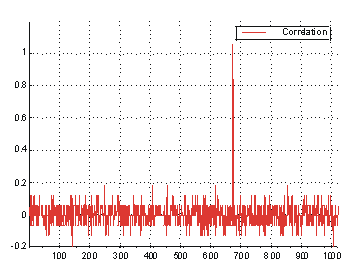
Figure 2. Auto-correlation: PRN 19
Figure 2 shows correlation between PRN codes for the same satellite, in the presence of PRN codes for two other satellites. Note the obvious correlation peak. The offset of the correlation peak from the start of the PRN code corresponds to the time difference between the start of the satellite's code sequence and the start of the receiver's local copy of the code sequence.
This time difference allows the receiver to determine the distance to the satellite. The PRN code identifies the satellite and the offset from the start of the local copy relates to the distance from that satellite. The receiver also has information about the orbit of each satellite. Determining location this way is called code phase operational mode and this is how the majority of stand-alone GPS receivers determine their location. The code phase mode estimates the instantaneous ranges between the receiver and the satellites in view based on the signal transit times. Transit times are calculated using the time shift between the generated PRN replicas and the received satellite signals.
Using the GPS signals we can accurately determine our location. Except, as was mentioned earlier, the Department of Defense can intentionally degrade the SPS accuracy by introducing a time varying bias called S/A into the L1 broadcast navigation message. When S/A is on it introduces an average pseudorange error of 20 meters that signidicantly degragates the positional accuracy by up to 100 meters.
On May 1, 2000, President Clinton announced that the United States has stopped the intentional degradation of the GPS signals available to the public. When S/A is turned off civilian users of GPS can determine locations up to ten times more accurately than before.
We may not be able to count on S/A always being turned off. When we are using GPS to control radio channel selection, the introduced errors from S/A cause the location solution to jump in and out of a defined coverage polygon. In this situation, which was typical until May 1, we utilized carrier-aided filtering to smooth out these errors and avoid jumping in and out of coverage. In order to employ carrier-phase smoothing of the code position solutions, the radio control software uses raw GPS data rather than the typical ASCII National Marine Electronics Association (NMEA) sentences. Then filtering is used to mitigate the random errors by smoothing the pseudoranges with a recursive, fading-memory filter. A filter length between 50 and 200 seconds is selected, depending on the application. The current-epoch code-phase measurement is weighted by the reciprocal of the filter length; measurements from previous epochs are used for high-accuracy forward prediction. The forward prediction will eventually break down due to code-carrier divergence in the ionosphere (a phenomenon of wave propagation where the phase and wave velocities differ). Selection of the proper filter length is a tradeoff between the very low noise of the carrier measurements and the accumulation of code-carrier divergence error.
We have seen how to use GPS to determine vehicle location. The next element of the AMCI system is predicting the coverage area of each P-25 base station.
When AMCI opened in 1987, we recognized that accurate RF performance prediction would be one of the key technologies needed to meet our system design responsibilities. This was at a time when commercially available packages focused mostly on impressive displays and reports rather than on accurate prediction models. We acquired and enhanced a number of prediction models. We didn't know how accurate our model was until 1997 when Harry Anderson published a comparison of various RF performance prediction models based on the model's ability to match carefully measured data collected by the Institute of Telecommunication Sciences (ITS). The RF propagation data base is referred to as the ITS R data. There are five sets of R data, data sets R-1 through R-5. There are about 50 paths per set, six frequencies and 13 antenna heights. Table 2 shows the results of various RF performance prediction models compared to the R data. Note not only the mean error but also the maximum error of some of the models. The data in the first two sections of Table 2 are from Anderson's article. The results of AMCI's model are included for comparison. Anderson selected only specific paths from the R data. AMCI used our model to compare against all valid entries of R data.
| Model | Paths | Mean Error (dB) |
Standard Deviation of Error |
MAX (dB) |
|---|---|---|---|---|
| R-1, R-2, R-3, R-4, R-5; 1392 Paths | ||||
| Free Space + Edwards-Peterson Diffraction | 1392 | 6.1 | 12.4 | 54.4 |
| Free Space + Edwards-Durkins Diffraction | 1392 | 7.8 | 12.4 | 54.5 |
| Free Space + ITU-Modified Deygout | 1392 | 11.6 | 17.6 | 79.8 |
| Hata/Davidson + Epstein-Peterson Diffraction | 1392 | 6.7 | 14.9 | 88.6 |
| Hata/Davidson + Edwards-Durkins Diffraction | 1392 | 5.1 | 13.4 | 87.9 |
| Hata/Davidson + ITU-Modified Deygout | 1392 | 26.7 | 21.9 | 108.9 |
| TIREM | 1392 | 6.6 | 15.3 | 51.9 |
| Longley-Rice 1.2.2 | 1392 | 0.2 | 11.7 | 72.9 |
| Anderson 2d v.100 | 1392 | 2.9 | 11.2 | 51.7 |
| R-3; 242 Paths | ||||
| Free Space + Edwards-Peterson Diffraction | 242 | 2.7 | 10.2 | 42.7 |
| Free Space + Edwards-Durkins Diffraction | 242 | 2.8 | 10.2 | 42.7 |
| Free Space + ITU-Modified Deygout | 242 | 2.5 | 15.2 | 88.7 |
| Hata/Davidson + Epstein-Peterson Diffraction | 242 | 21.1 | 18.3 | 85.3 |
| Hata/Davidson + Edwards-Durkins Diffraction | 242 | 21.1 | 18.2 | 85.3 |
| Hata/Davidson + ITU-Modified Deygout | 242 | 27.4 | 23.7 | 126.7 |
| TIREM | 242 | 0.5 | 10.6 | 47.2 |
| Longley-Rice 1.2.2 | 242 | 0.7 | 13.5 | 79.3 |
| Anderson 2d v.100 | 242 | 0.8 | 10.9 | 50.8 |
| R-Data; 9293 Paths | ||||
| AMCI | 9293 | 0.6 | 6.48 | 28.5 |
Table 2. Validation of RF Performance Prediction Models
The performance of the AMCI model is no accident. AMCI engineers, working in conjunction with propagation experts, have developed two contemporary, professional RF performance prediction models, integrated with digital topographic and morphographic databases, for predicting performance on a point-to-point or an area basis, from 30 MHz to 10 GHz. The best computational methods from several internationally recognized procedures have been selected and combined with unique and powerful original routines to predict path loss. In addition to public domain models, we are licensed by the Queen of England to use and modify Jim Whitteker's Communication Research Centre (CRC) performance prediction algorithm.
Calculation of diffraction loss in the CRC model is based on Fresnel-Kirchoff theory. Points along a two-dimensional great circle path between the transmitter and the receiver are treated as Huygens sources. A Huygens source is a point on a wave front which is regarded as the source of secondary waves; the surface that is tangent to these secondary waves is used to determine the future position of the wave front. The field strength at selected points along the path profile is determined by integrating the ray path through the terrain and clutter between the transmitter and the receiver.
An important concept in understanding diffraction is that of Fresnel zones. Fresnel zones are ellipses of revolution about the central ray between the transmitting and receiving antennae. Any path containing the transmitting antenna, a point on a Fresnel ellipse, and the receiving antenna is greater than the direct path between the two antennae by an integer multiple of one half the wavelength. Whenever an obstacle penetrates the first Fresnel zone, the radio shadow becomes fuzzy and diffraction is a factor in calculating attenuation above free space.
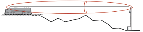
Figure 3. Fresnel zones are ellipses of revolution about the central
ray between the transmitting and receiving antennae.
Elevations in the path profile are adjusted for the effective earth radius and clutter height. Clutter height is determined from United States Geologic Survey land use/land cover (LULC) data. In order to reduce the number of calculations performed, only points for which a direct ray from transmitter to receiver does not have first Fresnel zone clearance are selected. Enough points are selected to adequately represent the terrain. Terrain between selected points is treated as flat or convex reflecting surfaces.
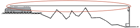
Figure 4. Points for which a direct ray from transmitter to receiver
does not have first Fresnel zone clearance are selected.
At each selected point along the path profile, numerous points at various elevations are selected. Field strength is determined at these points. Enough points are selected to ensure the calculations remain stable. Close to the ground, where the field strength varies rapidly with height, the points are close together. At greater elevation the points are farther apart. The highest four points are selected so they are illuminated by the transmitter.
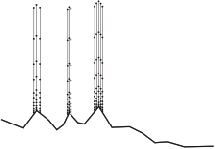
Figure 5. At each selected point along the path profile,
numerous points at various elevations are selected.
The field strength as a function of height at the first selected point is determined by adding the contributions of the direct and reflected fields. The field strength as a function of height at subsequent selected points is the sum of two integrals, one for the direct wave and one for the reflected wave.
Each point radiates what it receives. When the cumulative effect of all the points is calculated at the receiver the result is an accurate prediction of signal level. In addition to predicting a signal level we also want to predict the reliability of communications at a given location. This element of RF prediction is described in the next section.
Figure 6. Field strength for direct and reflected waves at each elevation for each selected point
along the path profile are calculated and combined to arrive at the right level at the receiver.
There are too many variables affecting RF propagation to take a strictly deterministic approach to performance prediction. Consequently, we use statistical methods to account for variability in RF signal quality. Atmospheric anomalies and localized terrain features are examples of variables that must be modeled statistically. Three dimensions of variability, statistical quantiles, are commonly recognized: time, location, and situation.
Time variability refers to the differences in signal level experienced over time at the same location. Time variability is sometimes referred to as the probability of achieving a specified grade of service at a particular point. We describe system performance with a statement such as "Along the specified path for at least x% of the time, the signal level exceeded w microvolts."
Location variability refers to the differences in signal level experienced over time from location to location. Location variability is sometimes referred to as availability. We describe system performance with a statement such as "Along at least y% of the paths, for at least x% of the time, the signal level exceeded w microvolts."
Situation variability refers to the differences in signal level experienced over time from location to location from one area to another. Situation variability is sometimes referred to as prediction error. We describe system performance with a statement such as "In at least z% of like situations, along at least y% of the paths, for at least x% of the time, the signal level exceeded w microvolts."
Different combinations of these quantiles are referred to as modes of variability. The mode of variability that is of interest for this discussion is the mobile mode. In mobile mode, time and location quantiles are combined for reliability while the situation quantile represents confidence. This statistic describes the probability of experiencing adequate service on a RF link at one location at a time. Mobile mode is of interest when designing a RF link with a stationary base station which will communicate with one mobile at a time.
We select a desired confidence depending on the type of radio service being considered. We typically design for 90% confidence. The result is a geographic representation of the locations where we have 90% or greater confidence in the radio system meeting the desired performance parameters. We call this our coverage map. The next step in the overall process is to convert the coverage map into a polygon with a limited number of vertices so that the coverage area can be defined by a reasonable number of coordinates. A genetic algorithm is used to complete this step.
"Genetic algorithms are search algorithms based on the mechanics of natural selection and natural genetics. They combine survival of the fittest among structures with a structured yet randomized information exchange to form a search algorithm with some of the innovative flair of human search. In every generation, a new set of artificial creatures is created using bits and pieces of the fittest of the old; an occasional new part is tried for good measure. While randomized, genetic algorithms are no simple random walk. They efficiently exploit historical information to speculate on new search points with expected improved performance." (Goldberg 1989)
In order to approximate a RF performance prediction using a genetic algorithm, we defined a mesh around each base station. The mesh is typically two degrees of latitude by two degrees of longitude. Each point on the mesh is 3 arc-seconds from each of its neighbors. The mesh consists of 1680 points about the base station. The received signal strength and reliability are calculated at each point of the mesh, using the techniques presented in the previous section.
Figure 7 depicts the coverage mesh for a base station. The points represent locations where we performed point-to-point RF performance prediction analyses: blue points have a predicted confidence greater than or equal to 90%; yellow points have a predicted confidence of less than 90%. The large white point in the center of the display is the location of the base station.
We generated a 90% contour from this data using bicubic hermite polynomials. A bicubic hermite polynomial [sixteen values at the vertices of every rectangle uniquely defines 16 coefficients of a bivariate hermite polynomial: the coordinate z, the two partial derivatives z(x) and z(y), and the twist, z(x,y); the polynomial is third-order on lines parallel to the cartesian coordinates x and y and sixth-order in all other directions] f(x,y) is determined for every rectangle of the mesh, interpolating the z(i,j), the derivatives z(x), z(y), and the twist z(x,y). The method is based on work done by Hiroshi Akima of the Institute for Telecommunication Sciences and Albrecht Preusser of Max Planck Institute.
The 90% contour is represented by the red lines in Figure 7. This is what we consider the base station RF coverage area. A genetic algorithm was used to run against this data in order to approximate the coverage areas using polygons with a specified number of vertices. We used a conservative evaluation function, assigning more weight to excluding areas without coverage than including areas with coverage and excluding non-simple polygons. The white line in Figure 7 indicates the 90% confidence contour of a RF performance prediction, approximated by a 16-vertex polygon.
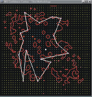
Figure 7. Predictive Coverage Grid for a Base Station
We approximated the RF performance prediction contours for the P-25 base stations in the ODOT pilot with 16- and 32-vertex polygons. The 16-vertex approximations are shown in Figure 8.
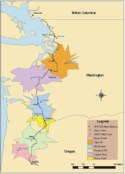
Figure 8. ODOT Pilot P-25 Base Stations
(Map generated using Esri ArcInfo)
We now know where we are from a GPS standpoint and we have polygons defining radio coverage areas. The remaining step is to combine the polygons with location logic to create event triggers when the locomotive enters or exits a coverage polygon. The event triggers are used to send appropriate control signals to the radio for channel or mode changes. Radio control decisions are driven by signals from the satellites of the GPS that allow the mobile computer to determine its location. The control software must take the GPS location and determine if the location lies within a polygon.
There are several methods for determining if a point lies within a polygon:
The first method states that a point p lies inside the polygon p0 p1 p2 ... pn p0 if and only if the area of the polygon is the sum of the areas of the two polygons pn p0 p pn (a triangle) and p p0 p1 p2 ... pn p. This method has proven numerically unsound in computer implementation, and is only valid for convex polygons.
The second method also works only for convex polygons. Imagine each face of the polygon to be a vector whose head is connected to the end of the following vector. This method determines whether the point in question is on the same side (i.e., to the left or to the right) of all the vectors. If not, the point is outside the polygon; if yes, the orientation of the vectors tells you that the point is inside the polygon.
The third method constructs a vector from the point in question to each vertex of the polygon sequentially and sums the angles so drawn (in the same order, including sum of last+first). If the point is inside the polygon, the sum will be 2*pi (sign may be plus or minus). If the point is outside the angles will zero out. This algorithm has the disadvantage that the calculations of the angles are given by the relations of the vectors and so may be slow in a real time situation.
The fourth and most elegant solution draws a ray from the point and determines if the number of sides of the polygon it intersects is even or odd. If the number of sides is even, the point is outside the polygon. If the number of sides is odd, the point is inside the polygon. This algorithm works for general polygons, not just convex or simple polygons.
We now have all the pieces necessary for the ODOT pilot test. The software on the locomotive can determine its location from GPS and decide which predicted coverage area it is in. Based on the attributes of the coverage area, the software can command the radio to the correct channel and mode. The full system implementation for the ODOT pilot is described in the next section.
The map in Figure 9 shows the route of Amtrak's Cascades service. P-25 base stations have been installed along this route and Amtrak locomotives will be equipped to support testing P-25 along this route.
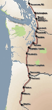
Figure 9. P-25 Base Station Locations
The pilot test is based on meeting Association of American Railroads (AAR) requirements for a railroad radio system. The AAR established specific requirements for interoperability of VHF radio equipment based on P-25 specifications. While P-25 supports a variety of data interfaces, the AAR committee identified that packet data and Low Volume data would be considered as standard items for the railroad radio service. This pilot will not be testing the Low Volume data facility that sends a 32-byte burst of data before and after each voice transmission. Confirmed delivery packet data will be tested. Confirmed delivery is a two-way data service between radio-network access points providing a variable rate of information transfer. Multi-access channel sharing techniques are used to provide a service which maximizes the utilization of network resources for information transfers which are of a short burst nature. Error correction/protection services are provided by the radio network. Confirmation of delivery is provided by the P-25 radio protocol stack.
The pilot test includes specific tests that will enable data throughput analysis to be measured. Each train will be equipped with a GPS receiver. In addition to reporting the train location and controlling the radio mode selection, the GPS data will be incorporated into the communications testing. GPS data will be included in messages from the communication testing application. The testing application will maintain a database of messages sent for use in later analysis. Based on the GPS data, time, location, and speed of the train sending any successful radio message will be known. The message delivery time across the network can be determined by comparing the GPS time at origination of the message to GPS time at the host server. The location and locomotive speed of failed messages will be determined by analysis of the train-born test application's message database.
A purpose of the pilot is to evaluate P-25 as a platform for PTS communications. PTS communications largely consists of location reports from locomotives and movement authorities issued to the locomotive from a dispatching application. These messages must be delivered reliably and quickly.
PTS location reports consist of 51 bytes of user data and represent the primary traffic load on the base station receive frequency. For the test, AMCI will configure equipment on each locomotive to send a 51-byte message at a configurable interval to the computer-aided dispatch (CAD) simulation application. Movement authorities will be addressed to individual mobiles from the CAD simulation application. The pilot test will use movement authorities of 127 bytes.
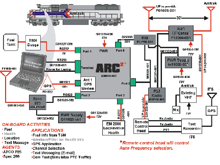
Figure 10. Equipment being installed on Amtrak locomotives for the pilot.
The central hub of the locomotive equipment is AMCI's Rugged Communications Computer (ARC2). The ARC2 is an industry standard Microsoft Windows operating system and an Intel-based personal computer (PC) platform uniquely designed to support multiple user applications through multiple mobile data communications paths in harsh environments. It contains interfaces to support data device input and interaction with an array of data radios, any of which can be automatically selected for individual message routing by communications middleware, such as AMCI's OptiPath�, which operates on the internal computer board. This open and modular architecture allows the ARC2 to be adaptable to almost any installation.
OptiPath is a middleware software product that provides seamless connectivity to multiple applications over multiple wireless networks concurrently. This isolates applications from networks. OptiPath relies on easily customized business rules to select the most appropriate network based on cost, availability, and message priority. OptiPath runs on industry standard Windows and Intel platforms and is provided with a published Application Programming Interface (API) for program development and integration. For the ODOT pilot OptiPath is routing traffic over P-25 and Spec 200.
The ARC2 contains a GPS receiver and serial data interfaces for connection to locomotive health and fuel sensors. The ARC2 provides a S200 interface to the Mobile Communications Package (MCP) and an asynchronous serial data interface to the P-25 radio. There is also a serial data connection for an external PC. Another serial interface is used to control the Motorola P-25 radio mode and channel selection based on GPS coordinates and a database of radio coverage areas.
Motorola supplies the locomotive P-25 mobile radio. The radio is configured for narrow band digital operation and equipped for operation with a detachable control head. The control head interface will be used to control the radio channel from the mobile computing platform based on a license from Motorola to use their proprietary SB9600 Bus Technology.
A Spec 200 MCP and power supply will be installed on the locomotive. The MCP will be used by the mobile computing platform to route traffic over the existing Union Pacific Spec 200 communications infrastructure. Performance of the P-25 system will be compared to the Spec 200 system. Spec 200 is a standard established by the AAR for data radio equipment operating at 900 Mhz.
Another interesting device in the test is the American Nucleonics RF Cancellation Device installed between the existing VHF voice radio and the P-25 VHF radio. Each radio is a source of possible interference for the other. Part of the pilot test will be to determine if this interference can be reduced using an active cancellation device. American Nucleonics is providing equipment designed to minimize the interference between the existing voice radio and the P-25 radio by sampling the signal transmitted out of one antenna and cancelling any of that signal received from the other antenna. This active cancellation is expected to improve the isolation between the two radios.
Figure 11 shows the physical configuration of this equipment as it will be mounted in the locomotive.
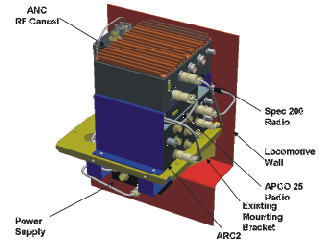
Figure 11. Locomotive Equipment Configuration
As a separate project, the ODOT will provide passenger information displays at Amtrak stations indicating, among other things, the expected time of arrival (ETA) for Amtrak trains. In support of this project, AMCI will provide the current location report and time over the Internet. The ODOT Passenger Information Server will "pull" location data from the AMCI database table. Figure 12 illustrates this architecture.
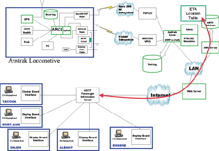
Figure 12. Location and Time Reporting System Architecture
| AAR | Association of American Railroads |
| AMCI | Automated Monitoring and Control International |
| ANC | American Nucleonics Corporation |
| APCO | Association of Public Safety Communications Officials |
| API | Application Programming Interface |
| ARC2 | Rugged Communications Computer |
| BPS | Bits per Second |
| C/A | Clear/Coarse Acquisition Code |
| CAD | Computer-Aided Dispatch |
| CRC | Communication Research Centre |
| Esri | Environmental Systems Research Institute, Inc. |
| FCC | Federal Communications Commission |
| FRA | Federal Railroad Administration |
| GIS | Geographic Information System |
| GPS | Global Positioning System |
| ITS | Institute of Telecommunication Sciences |
| L1 | Primary GPS Frequency, 1.57542 GHz |
| L2 | Secondary GPS Frequency, 1.2276 GHz |
| LULC | Land Use/Land Cover |
| MCP | Mobile Communications Package |
| NAC | Network Access Code |
| OCS | Operational Control System |
| ODOT | Oregon Department of Transportation |
| P Code | Precise/ Protected Code |
| P/Y | Precise/Encrypted Code |
| P-25 | APCO Project 25 |
| PC | Personal Computer |
| PPS | Precise Positioning Service |
| PRN | Pseudo-Random Noise, also known as Gold Code |
| PTS | Positive Train Separation |
| RF | Radio Frequency |
| RHCP | Right-Hand Circularly Polarized |
| S/A | Selective Availability |
| SPS | Standard Positioning Service |
| VHF | Very High Frequency |
| Y Code | Encrypted P Code, also known as Anti-Spoof (AS) Code |
AMCI, OptiPath, OptiTrac, OptiTrac Plus, and other related trademarks, service marks and logos used in this document are trademarks or registered trademarks of Automated Monitoring and Control International, Inc. All other product names, company names, and services identified in this document are trademarks or registered trademarks of their respective companies. Any use thereof without the express written permission of AMCI is expressly prohibited.
� 2000 Automated Monitoring Control International, Inc. All rights reserved. No part of this publication may be reproduced without the written permission of Automated Monitoring and Control International, Inc. 9119 Western Ave, Omaha, Nebraska, 68114.
Akima, H. A Method of Bivariate Interpolation and Smooth Curve Fitting Based on Local Procedures. ACM Transactions on Mathematical Software, Vol. 4, No. 2, Pages 148-159, June 1978.
Allister, D. F. and J. A. Roulier. An Algorithm for Computing a Shape Preserving Osculatory Quadratic Spline. ACM Transactions on Mathematical Software, Vol. 7, No. 3, Pages 331-347, September 1981.
Anderson, H. R. New 2D Physical EM Propagation Model Selected. IEEE Vehicular Technology Society News, Pages 15-22, August 1997.
Anonymous. Interface Control Document ICD-GPS-200. Fountain Valley, California: Arinc Research Corporation, July 1991.
Brunet, P. Increasing the Smoothness of Bicubic Spline Surfaces. Computer Aided Geometry. Des. 2, Pages 157-164, September 1985.
Dana, Peter H. The Geographer's Craft Project. Department of Geography, The University of Texas at Austin.
Department of Defense. World Geodetic System 1984: Its Definition and Relationships with Local Geodetic Systems, 2nd Edition. September 1991.
Enge, P. K. Local Area Augmentation of GPS for the Precision Approach of Aircraft. Proceedings of the IEEE, Vol. 87, No. 1, Pages 111�132, January 1999.
Enge, P. K. The Global Positioning System: Signals, Measurements, and Performance. International Journal of Wireless Information Networks, Vol. 1, No. 2, 1994.
Farrell, J. A. and M. Barth. The Global Positioning System & Inertial Navigation. New York: McGraw-Hill, 1999.
Fritsch, F. N. and R. E. Carlson. Monotonicity Preserving Bicubic Interpolation: A Process Report. Computer Aided Geometry. Des. 2, Pages 117-121, September 1985.
Furman, E. L. and S. C. Lampe. RF Performance Prediction: Reliable Wireless Communication for the Rail Industry, Pages 500-527. Association of American Railroads 1996 Committee Reports and Technical Papers, Thirty-Sixth Annual Technical Conference, Communication and Signal Section. Association of American Railroads, Washington, D.C., 1996.
Goldberg, D. E. Genetic Algorithms in Search, Optimization & Machine Learning. Reading, Massachusetts: Addison-Wesley, 1989.
GPS 35 LP TracPak GPS Smart Antenna Technical Specification. Olathe, Kansas: Garmin Corporation, January 1998.
IEEE Vehicular Technology Society Committee on Radio Propagation. Coverage Prediction for Mobile Radio Systems Operating in the 800 / 900 MHz Frequency Range. IEEE Transactions on Vehicular Technology, Volume 37, No.1, Pages 3-72, February 1988.
IS102.BAAA. Project 25 FDMA Common Air Interface, Telecommunications Industry Association, April 1998.
IS102.BAEA. Project 25 Data Overview, Telecommunications Industry Association, January 1998.
IS102.BAEB. Project 25 Packet Data Specification, Telecommunications Industry Association, April 1998.
IS102.BAEE. Radio Control Protocol, Telecommunications Industry Association, January 1998.
Jay, F. IEEE Standard Dictionary of Electrical and Electronics Terms. New York: Wiley-Interscience, 1977.
Jennings, R. D. and S. J. Paulson. Communication System Performance Model for VHF and Higher Frequencies. U. S. Department of Commerce, OT Report, Pages 77-128, October 1977.
Koza, J. R. Genetic Programming. Cambridge: MIT Press, 1992.
Lampe, S.C. Differential GPS: A Tool for Rail Yard Track Determination. Graduate Term Paper, Stanford University, Stanford, California, Spring 1999.
Lee, W. C. Y. Mobile Communications Engineering. New York: McGraw-Hill, 1982.
Longley, A. G. and P. L. Rice. Prediction of tropospheric radio transmission loss over irregular terrain. U. S. Department of Commerce, ESSA Report, ERL-79-ITS-67, 1968.
Misra, P., B. P. Burke, and M. M. Pratt. GPS Performance in Navigation. Proceedings of the IEEE, Vol. 87, No. 1, Pages 65�85, January 1999.
NMEA 0183 ASCII Interface Specification, Version 2.0. National Marine Electronics Association.
Preusser, A. Computing Contours by Successive Solution of Quintic Polynomial Equations. ACM Transactions on Mathematical Software, Vol. 10, No. 4, Pages 463-472, December 1984.
Robinson, A. H., J. L. Morrison, P. C. Muehrcke, A. J. Kimerling, and S. C. Guptill. Elements of Cartography, New York: John Wiley & Sons, 1995.
Software Engineering Institute (SEI), Carnegie Mellon University, 1999. http://www.sei.cmu.edu/str/descriptions/clientserver_body.html
TSB102-A. APCO Project 25 System and Standards Definition. Telecommunications Industry Association, November 1995.
Whitteker, J. H. Fresnel-Kirchoff Theory Applied to Terrain Diffraction Problems. Radio Science, Vol. 25, No. 5, Pages 837-851, September-October 1990.
Whitteker, J. H. The CRC VHF/UHF Propagation Prediction Program. Beyond Line-of-Sight Conference, Austin, August, 1994.
Whitteker, J. H. Users' Guide to the CRC VHF/UHF Propagation Prediction Program. Ottawa: Communications Research Centre, September, 1992.
Wyatt, S. P. and J. B. Kaler. Principles of Astronomy: A Short Version. Boston: Allyn and Bacon, 1974.