Abstract
While the extraction of hydrologic features from digital elevation data has a well-established scientific utility, the applications of these techniques have been hindered by data availability and quality. The National Elevation Dataset (NED) is a seamless assembly of best-available digital elevation data with processing performed to address production artifacts, seams, errors, and inconsistencies that inhibit analysis. The National Elevation Dataset Hydrologic Derivatives (NED-H) is a systematic approach to derive stream lines and watersheds from NED. The NED-H will provide catchment delineations, synthetic stream networks, overland slopes, elevations at confluences, and stream gradients
Introduction
Increasingly, many local, state and federal agencies that have the mandate for management of water resources are finding that their needs are not being met by existing digital data sets. Current national coverage of digital data sets, such as drainage basin boundaries and consistent elevation-derived parameters, do not exist or are not of a suitable scale or consistency to allow management of small or mid-size watersheds. This problem becomes more significant as the management of water resources, both in terms of quantity and quality, is becoming more and more based on the watershed scale.
The recent completion of the National Elevation Dataset (NED) and the National Hydrography Dataset (NHD) has provided an avenue for nation-wide development of topographically derived hydrologic data layers at a scale of 1:24,000. This dataset of hydrologic derivatives, entitled the National Elevation Dataset - Hydrologic Derivatives (NED-H) , is being developed by a consortium of participants including the U.S. Geological Survey (USGS), National Weather Service (NWS), Environmental Protection Agency and others. The multi-layer dataset is being developed to meet the needs of the user community for consistently derived hydrologic derivatives. Work is being done to ensure that the NED-H is consistent with other national data sets. These data layers, produced in a consistent national fashion and quality controlled by local or regional stakeholders, will provide a level of data coverage and quality that has not been available until now.
NED-H Development Rationale
The extraction of hydrologic information from digital elevation models has a long history and a well-established scientific utility. On a national level, however, the quality and consistency of the extracted information has been limited by the quality of the underlying Digital Elevation Models (DEMs). Up to now, the best-available digital elevation data over the United States have been incomplete and affected by production artifacts, seams, errors, and inconsistencies that inhibit analysis.
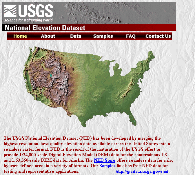
The recent completion of the National Elevation Dataset has resolved many of these problems (Figure 1). NED is a logically-seamless, multi-resolution, best-available national elevation dataset with a resolution of one arc-second (approximately 30 meters) or finer. In development of the NED, USGS-led research has produced efficient filtering algorithms to reduce or remove many of the production artifacts apparent in the Level 1 DEMs, adjust edges between adjacent DEMs and fill sliver areas. These artifacts and edge-matching errors have been a major barrier for the user community and created great difficulty in the assembly of seamless databases and in the generation of elevation derivative information. The NED-H dataset would not have been made possible without the completion of the NED.
Benefits of development of a nation-wide dataset of hydrologic derivatives are many.
NED-H Dataset Description
The NED-H is planned to be a multi-layer, multi-format dataset derived from the NED. The dataset will be in U.S. Albers projection with the following projection parameters:
| 1st standard parallel | 29 30 0 |
| 2nd standard parallel | 45 30 0 |
| Central meridian | -96 0 0 |
| Latitude of origin | 23 0 0 |
| False easting | 0 |
| False northing | 0 |
The core NED-H data layers will be modeled on the HYDRO1k global dataset (Verdin, et al, 2000) developed from the USGS� GTOPO30 DEM. Many of the procedures utililized in the NED-H development have their roots in the HYDRO1k effort. The envisioned core layers, all derived using ARC/INFO's hydrologic tools, are:
CTI = ln ( A / tan (beta) ),
where A = upstream area calculated as (flow accumulation + 1 ) * (pixel area in m2)
and beta is the slope expressed in
radians.
NED-H Development Stages
The development of the NED-H dataset is planned to proceed in three stages.
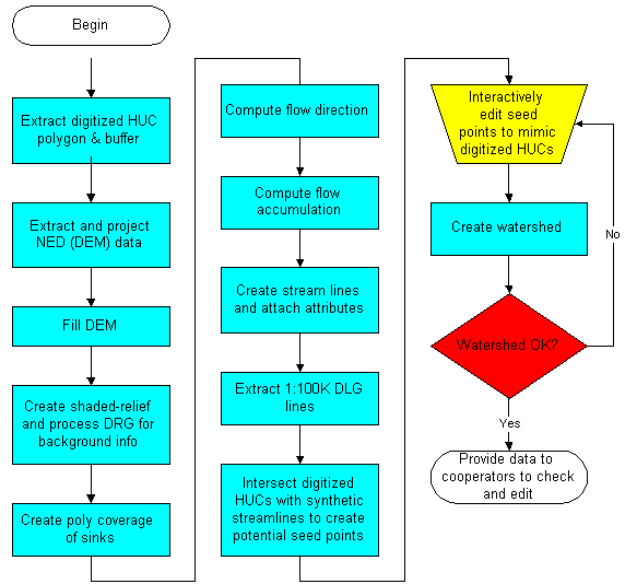
Stage 1: Blind Pass Processing
The blind pass processing of the NED into a Stage 1 NED-H product is currently being done by a
participant in the NED-H consortium, the National Weather Service Severe Storms Laboratory in Norman,
OK. The NED is being processed on a Cataloging Unit by Cataloging Unit basis using semi-blind techniques,
developed at the EROS Data Center (EDC), to remove spurious depressions from the DEM while maintaining
natural sink features in the landscape (Figure 2). The resulting flow direction and flow accumulation data
sets are also developed, as well as an initial synthetic streamlines dataset, reach catchments and a
NED-H derived Cataloging Unit boundary. The output from the Stage 1 processing will be an initial
version of the NED-H which will be subject to intensive QA/QC procedures in subsequent stages.
Stage 2: Vector Editing
The delineations produced in Stage 1 will be passed on to appropriate cooperators, who will provide an
intensive QA/QC. A multi-stage checking procedure is being developed at EDC to ensure that the Cataloging
Unit is subjected to a thorough examination.
Synthetic streamlines are compared with mapped
hydrography (NHD) and the derived watershed boundaries are compared with existing basin delineations.
Along with flagging of errors in the NED-H derived products, watershed and subwatershed delineations are
made for incorporation into the WBD.
Stage 3: Raster Editing
The results from the Stage 2 delineation will be incorporated into the NED-H development process.
Drainage basin areas and synthetic streamline locations found to be in error at Stage 2 will be
reanalyzed and, if necessary, the DEM will be reprocessed to ensure that the newly derived streamlines and
basin boundaries are consistent with those developed in Stage 2. Delineations derived in this fashion
retain the desirable relationship between the DEM and the derivatives. A user of the NED-H could be
confident that vertical integration among the NED-H, NHD and the WBD was achieved.
While the NED-H will not be fully integrated with the other data layers until the completion of Stage 3, the output from the preliminary stages has value as well.
At the completion of Stage 3 the datasets are fully consistent � with the NED (as NED-H), NHD and the WBD vertically integrated.
Current Status and Future Plans
The development of a Stage 1 NED-H product is well underway through the participation of the NWS/NSSL. A status map of their efforts (as of June 2000) can be found at by following the link at the bottom of the page at http://www.nssl.noaa.gov/teams/western/basins/. Details on the NED-H development plans can be found on the NED-H web pages (http://edcnts12.cr.usgs.gov/ned-h).
Prototypes of Stage 2 and Stage 3 processing have been completed for numerous locations throughout the country. To facilitate participation by additional cooperators, work is underway by the USGS through a CRADA with Esri to streamline and optimize development of tools for use in the Stage 2 and Stage 3 development. In order to enhance the possibility of a successful Stage 3 NED-H product, the project is actively pursuing collaboration with potential data users, with local and regional knowledge, across the country. The Stage 2 QA/QC is critical for acceptance of the final data product by the user community.
References
Seaber, P., F. Kapinos, and G. Knapp, 1987, Hydrologic Unit Maps, USGS Water Supply Paper 2294, 63 p.
Verdin, K., J. Danielson and J. Dvorsky, 2000, "Development of a Global Hydrologic Derivative Data Base (HYDRO1k)", in preparation
Verdin, K.L. and J.P. Verdin, 1999, A topological system for delineation and codification of the Earth�s river basins, Journal of Hydrology, vol. 218, nos. 1-2, pp. 1-12