The New Mexico Office of the State Engineer (OSE) is charged with administering the state's water resources. To accomplish this, OSE has setup a strategic plan with four priorities: eliminate the water rights application backlog; protect New Mexico's water and meet interstate obligations; complete water rights adjudication; and automate information and processing of its databases.
The OSE is using Geographic Information System (GIS) and Information Systems (IS) tools to accomplish these priorities. OSE has initiated the first steps in the adjudication process: to abstract its paper/document information databases and to automate its hydrographic surveys, through an innovative approach using private enterprise to create a computer-based IS/GIS for the Hydrographic Surveys of the Lower Rio Grande and Nutt-Hockett Basins. How the surveys were conducted, how the adjudication process works, the IS/GIS created, and the lessons learned will be presented.
Wet water is how we like to think of the liquid that gives New Mexico its life. Nuestra agua, nuestra vida is how people think of water, not as a commodity but as an element of economic, social and cultural life. We live in a semiarid region where water is in limited supply, and we must conserve, preserve and protect it. That is why adjudication of water rights is so important; we need to make sure use of water is provided to everyone, for everyone is us.
The New Mexico Office of the State Engineer (OSE) is charged with administering the state's water resources. To accomplish this, OSE has setup a strategic plan with four priorities: eliminate the water rights application backlog; protect New Mexico's water and meet interstate obligations; complete water rights adjudication; and automate information and processing of its databases.
Most of the written record of present-day New Mexico's water rights allocation begins in late 1600s and continues today. The process is a long and complicated issue, which appears to have no ending. What we will be presenting is the latest chapter of our work; a chapter mostly dedicated to technical efforts to update the database on which we build the water right of an individual.
The Office of the State Engineer (OSE) is the state agency in charge of administration of the rights to beneficially use water, which the state's constitution declares to be the property of the public. Water is defined as surface and ground waters, and separate state laws govern their use. The surface water code was enacted in 1907 by the Territorial Legislature, and confirmed the validity of all rights which existed prior to its enactment (Spanish and Mexican periods). The ground water code was enacted in 1931 and includes the administration of water within declared groundwater basins, which total 32 basins that cover 85% of the state.
The adjudication of water rights process seeks to establish these basic elements:
The process involves two distinct phases: a technical one in which a hydrographic survey is conducted, and a legal one in which a lawsuit is filed by the state.
The technical phase is mandated by state law, which requires the State Engineer to conduct hydrographic surveys of all watercourses (rivers, arroyos, creeks, canyons, draws or washes, or any other channel), and underground basins. There are at least 83 hydrologic units in New Mexico, which could be considered surface watercourses, and there are 32 declared underground basins, which leaves about 15% of the state undefined. Further, mapping of these features has to be done at large scales, done quickly, with high precision and accuracy, and involving large amounts of manpower.
The legal phase is determined by the fact that the state must bring a lawsuit in court to adjudicate a water right. This process has to take into account legacy of laws and regulations from the Spanish and Mexican government periods, the Territory status of New Mexico in 1907, and its State status after 1912. These internal issues are complicated by the several compacts the state has entered with neighboring states, the recent lawsuits brought by the state of Texas, and by the resulting new legal procedures ordered by the courts.
The new legal procedures entail changes in service of process of defendants, where all defendants are joined, could be served by mail, using specific form answers produced in English and Spanish, and are subject to default judgement if defendants fail to follow the procedures. These new legal procedures also contain Alternative Dispute Resolution (ADR), whereby state and defendants are encouraged to resolve disputes through informal resolution, and if failing to do so the court could impose mediation and mediator intervention.
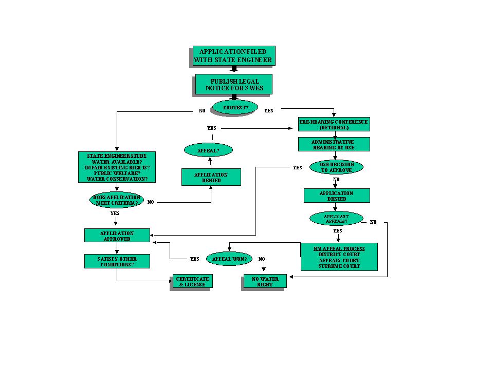
The process also has an administrative path to be followed when adjudicating water rights or obtaining a well permit. The figure below shows how we proceed in New Mexico. Notice that once the OSE has issued a given response, the claimant can still appeal the decision to a higher court.
The hydrographic survey is a process whereby data and information are collected to determine ownership, place of use, priority and extent of water rights in a given watercourse or underground basin. The data and information collected refer to aerial photography or digital imagery, field information, documents or abstracts of water rights, reports, and interviews. These data and information are compiled to produce maps and water right abstracts to form a Final Hydrographic Survey Report.
These in turn are used to generate offers of judgement, sent to claimants and which can then be amended to conform to the material on which a final order is entered. The final order confers title to the water right, removing any question regarding the validity of the right.
In the early days of the agency, between 1907 to late 1930s, plane tables were used to produce the maps on which the offers of judgement were based. These early surveys were mostly manual and the surveying equipment consisted of plane tables, alidades, transits and measuring tapes. Whatever aerial photography was available it was used to annotate field observations about crops, roads and buildings. From the 1930s to late 1950s, theodolites, transits and aerial photography were used together with restitution equipment. This equipment was used to re-project the central projection aerial photograph to an orthogonal projection or map. The 1960s to late 1980s were a period when more sophisticated restitution and long-distance measuring equipment were used. During this period it was common to produce orthophotos which served as maps in the field.
We have begun referring to the above hydrographic surveys as "old surveys" as opposed to the "new generation" hydrographic surveys started in the 1990s.
The 1990s to the present have seen a quantum change in the way hydrographic surveys are conducted at OSE today. Aerial photography, satellite imagery, airborne multi-spectral imagery, global positional systems (GPS), geographic information systems (GIS), computer-based information systems (IS) and digitally ortho-rectified imagery are the "new generation" hydrographic survey staples.
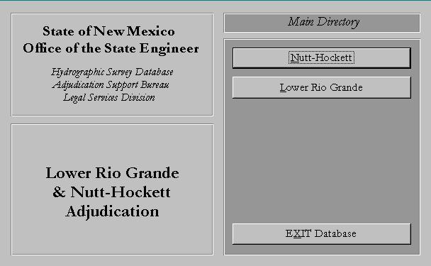
The OSE is using GIS and IS tools to conduct hydrographic surveys. OSE has initiated the first steps in the adjudication process: to abstract its paper/document information databases and to automate its hydrographic surveys, through an innovative approach using private enterprise to create a computer-based IS/GIS for the Hydrographic Surveys of the Lower Rio Grande and Nutt-Hockett Basins.
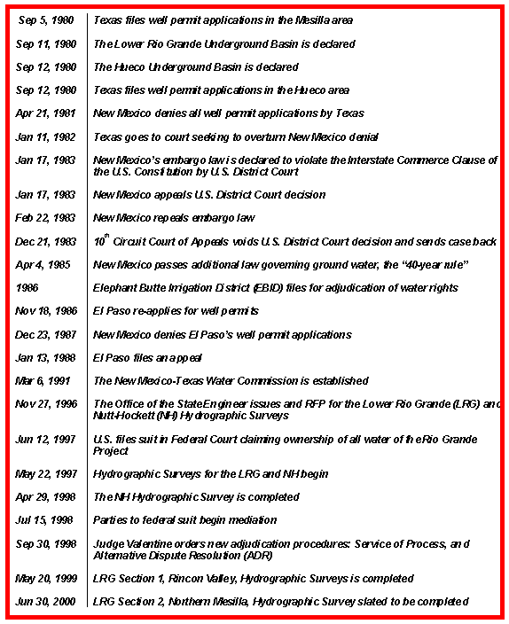
The OSE has been using computers in all aspects of its work since the early 1980s, and received a big push to computerize its databases in the early 1980s when out-of-state claims on its water became an issue. The state of Texas could be credited with accelerating the computerization of the OSE.
On September 15, 1980 Texas filed well permit applications to drill wells in the Mesilla area, near El Paso. This precipitated a series of actions by the State of New Mexico that culminated in the New Mexico ex rel. Office of the State Engineer v. Elephant Butte Irrigation District, et al. Doña Ana County Case No. 96-88-CV 1996 suit. Eventually, the United States filed suit in Federal Court claiming ownership of all water of the Rio Grande, encompassing the Lower Rio Grande basin. The table below shows the historical highlights of this process, already 20 years old.
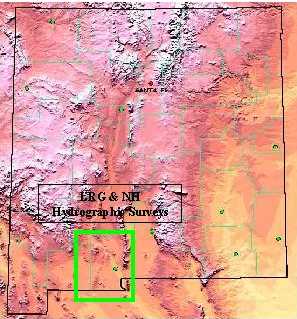
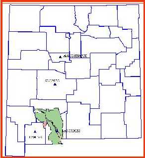
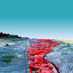
This series of events coalesce into a request for proposals (RFP) issued by OSE in November of 1996 to conduct hydrographic surveys for the Lower Rio Grande (LRG) and the Nutt-Hockett (NH) Underground Basins. These surveys were necessary to answer the claims of the Elephant Butte Irrigation District (EBID), the City of Las Cruces, the City of El Paso, TX, the State of Texas and the U.S. government. The general location of the surveys is shown on the figures below.
 |  |
OSE's approach to conducting a hydrographic survey in the shortest possible amount of time was an innovative one. Under this approach private enterprise was brought to create a computer-based IS/GIS for the LRG and NH basins, the first of the "new generation" hydrographic surveys. Innovative because private enterprise had not figured this large on the conduct of hydrographic surveys; innovative because the surveys were planned from the start to be computer-based using the latest GIS/GPS and multi-spectral analysis techniques; and innovative because funding was secured by issuance of revenue bonds. The results of these surveys will establish the technical procedures that OSE will use well into the 21st Century.
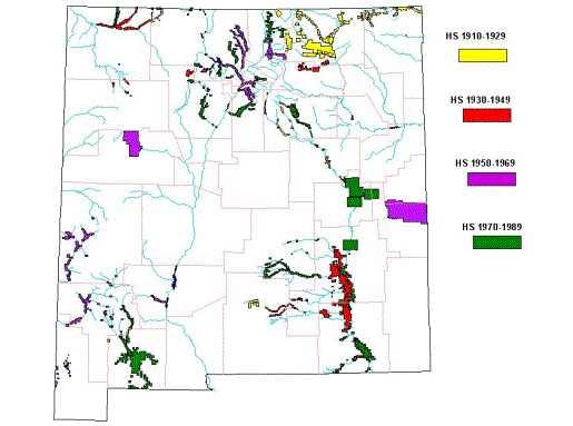
The OSE has conducted several hydrographic surveys from 1907 to late 1980s, surveys that we referred to as "old" hydrographic surveys. The manner by which these surveys were produced is the manual or traditional way, where little computer techniques were used. The first step in the process is the research of the documentation of the water right, or abstracting the water right record. The surveys then used plane tables, alidades, theodolites, transits, measuring tapes, stereoscopes, radio and light measuring devices, aerial photography, ground control, aerial triangulation, stereo compilation using stereo plotters, field verification, and final map editing. Further, GIS, GPS and IS techniques were all but absent.
From these techniques the eventual result was a map on paper or cloth, which was then filed on map cabinets. The documentation, the Final Report, was on paper and also filed away. These hydrographic surveys usually took years to complete, and the adjudication process took several decades, with some of these "old" surveys and adjudication still on going.
The figure below shows the hydrographic surveys conducted between 1907 and the late 1980s.
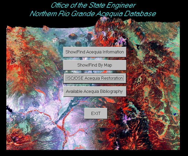
The OSE holds all these surveys on a paper format and has been trying to capture them on a computer-based GIS. To this effect, an interface has been created using ArcView and Microsoft Office Access software packages 2. The interface allows a prospective user, technical or attorney user, to query the two types of data input into the interface: the spatial and the tabular data. We have chosen these software because they are widely used within the OSE.
So far, three surveys have been input into this type of interface: the Rio Pueblo de Taos, the Carlsbad Irrigation District, and the Gallina Section of the Chama Hydrographic Surveys. Our present plans call for input of hydrographic survey information of another two areas, the Taos Pueblo and the Santa Cruz, into this type of interface. In the Taos Pueblo we are determining historical irrigated areas using aerial photography from the 1930s to the 1990s. The information will be introduced into an ArcView-Access interface, which can then be queried by attorneys. In the Santa Cruz area we will create a database containing information from the 1959 Upper Rio Grande Hydrographic Survey Santa Cruz River Section and recent requests for correction of acreage filed by parcel owners.
The advent of the computer and its wide use that occurred in the early 1980s changed the way the OSE conducts its hydrographic surveys. The first steps were to computerize the massive water rights documentation, which culminated in the mid 1990s with the development of a computer-imaging and database system called Water Administration Technical Engineering Resource System, WATERS. Once completed, WATERS will allow users to abstract the water right file, which will be related to an individual farmer's parcel and the eventual perfecting of the farmer's water right.
At about the same time, OSE decided to make the transition from traditional, non-electronic methods of data collection and data management to computer-based hydrographic surveys. The LRG and NH hydrographic surveys were started in mid-1997 and were designed to interface the written documentation or tabular data (descriptive information), and the digital map data (spatial information), and make the data and information so developed available to a user through a computer.
The descriptive information, mostly water rights records, was analyzed and abstracted records were obtained, each one constituting the "subfile", a unit describing a farmer's tract/plot of land. These subfiles were assigned a unique identifying number on the computer-based system, which now became the Information System or IS.
To create the necessary spatial information, ground control was established along the irrigated portion of the Lower Rio Grande, and aerial photography and multi-spectral imagery were obtained. The ground control was used to control the aerial photography and produce ortho-photos of the irrigated areas, ortho-photos that were then digitized and introduced into a Geographic Information System or GIS. The multi-spectral imagery, already on a digital format, was then geo-corrected using the ortho-photos and introduced into the GIS.
Parallel to these activities extant maps and geo-referenced information - including state and county boundaries, city locations, lakes and rivers, roads, townships, ranges, sections, PLSS data, satellite imagery and field-obtained GPS data - were collected and brought into the GIS. All spatial information was brought to a common projection, NAD83 and State Central Zone.
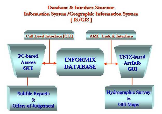
The IS and GIS were interfaced using Informix and ArcInfo software respectively. The IS/GIS application was housed on a computer and peripheral setup specifically built to house it under UNIX. At the same time, a series of Graphical User Interfaces or GUIs were developed to handle the IS/GIS data on the UNIX and on a PC-environment. This PC-environment was configured so Microsoft Access can access, view and query the descriptive Informix database and using ArcView to view and query the spatial database.
The figure below is a schematic representation of this IS/GIS.
An integrated IS/GIS is essential to the way hydrographic surveys are now handled by OSE. It allows us to print at will the Final Report and all necessary maps, as well as the approximately 10,000 Offers of Judgement to potential claimants of the LRG and NH basins in a matter of weeks. The Nutt-Hockett basin hydrographic survey itself was completed in about seven months and more than 90% of the offers have been accepted, making this an adjudication almost completed in less than two years.
The Rincon Section, part of the Lower Rio Grande Hydrographic Survey and containing about 1,200 potential claimants, was completed in about 18 months. Most of the Offers of Judgement in this Section have been sent out and we expect to have the adjudication complete in about 2-3 years.
The Northern Mesilla Section, the second part of the Lower Rio Grande and containing about 2,400 claimants, will be completed by June 30, 2000. This is, in about 30 months. The Southern Mesilla and the Outlying Areas, the other two sections of the Lower Rio Grande Hydrographic Survey, will be completed by the end of the year, about 36 months since starting the project. These two sections contain about 6,000 claimants, and their adjudication may take close to five years.
Strong emphasis has been placed on obtaining "user friendly" products for both OSE immediate users: technical and legal personnel. The several GUIs produced and the fact the IS/GIS can be used on a PC-environment are the most obvious "user friendly" outputs so far.
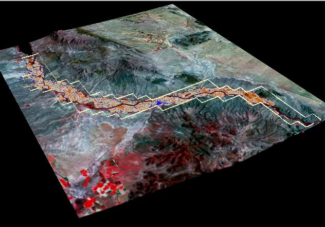
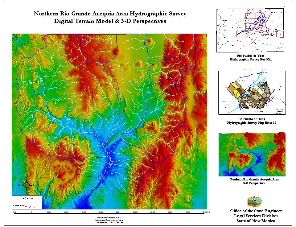
During the conduct of these new generation hydrographic surveys we have collected airborne multi-spectral and satellite imagery, USGS Digital Ortho Quad and Quarter Quad (DOQ and DOQQ) data, digital elevation models (DEMs), well data, and digital line graphs (DLGs). Using these data and visualization tools from ArcView 3D-Spatial Analyst and ERDAS Imagine software, we have put together 3D views of our study areas.
The figures below show some of these products generated for the LRG, NH and the Northern Rio Grande Acequias (NRGA-GIS).
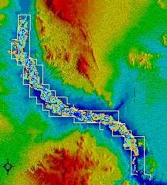 |  | |
| Rincon Valley Section | ||
| Digital Terrain and 3-D Perspective | Landsat Image Draped on DEM | |
 |  | |
| "Fly-By" Over LRG Basin | GUI for LRG & NH Hydrographic Surveys | |
 |  | |
| Northern Rio Grande Acequias Geographic Information Source (NRGA-GIS) | ||
Besides these visualization tools, useful when presenting results to non-technical audiences and for administration of resources, we have produced Portable Document Format (PDF) files. These PDF files of the Final Hydrographic Surveys for the Nutt-Hockett and the Rincon Valley Section of the Lower Rio Grande Basin have been placed on our web site, www.ose.state.nm.us. The main objective of this action by OSE is to make these surveys available to the public in general.
In late 1999 the OSE initiated another action to determine the future use of GIS in the agency. A study was contracted out to the private sector to help OSE in the development of an enterprise wide GIS. This Enterprise GIS study has three main components: develop a detailed project plan; develop a detailed GIS design; and implement a GIS pilot project. This study will be completed by the end of 2001 and will guide the use of GIS in the OSE for the foreseeable future.
What we expect in the future computer-based hydrographic survey work in the OSE is the following:
As was mentioned before, the two hydrographic surveys completed in the NH and the LRG areas are already on our web site, www.ose.state.nm.us.
The Access GUIs already developed are now being used by our technical people in two laptops we use for demonstration purposes of both the LRG and NRGA-GIS work.
Several "fly-by" movies have been produced for the NH, LRG and the NRGA areas, as well as 3-D posters we have distributed in New Mexico.
We are putting together a new hydrographic survey for the Fort Sumner area in central-east New Mexico using the ideas developed in the last three years. We will be interacting spectral analysis of Landsat data with GPS observations in the field and inputting results into a laptop using the Access-ArcView interface developed.
We have obtained spectral digital data in the northwest part of the LRG Outlying Areas. These data were used to produce ortho-rectified maps that are being field checked the same way we did the rest of the LRG and NH. We are replacing the obtaining of the central projection, analog aerial photograph by a digital ortho-rectified image that is input into the GIS directly.
In our Fort Sumner hydrographic survey we are planning to spectrally analyze satellite imagery for crop identification.
We are perhaps six months away from using a prototype of field checking that we expect will integrate GIS/GPS/Orthomap data into a system that will let our personnel see exactly where they are when walking around a given tract or plot of land.
2 The Office of the State Engineer does not endorse or promote any of the software mentioned in this article. The names used are trademark of given manufactures and it is not the intent of OSE to suggest their use or adoption.
Authors:
Dario Rodriguez-Bejarano, Legal Services Division, Office of the State Engineer, P.O. Box 25102, Santa Fe, NM 87504-5102. Telephone (505) 827-6150, FAX (505) 827-3887, E-mail drodriguez@seo.state.nm.us.
Ted Apodaca, Director Legal Services Division, Office of the State Engineer, P.O. Box 25102, Santa Fe, NM 87504-5102. Telephone (505) 827-6150, FAX (505) 827-3887, E-mail tapodaca@seo.state.nm.us.