 |
 |
 |
 |
 |
 |
 |
Information Center for the Environment
Department of Environmental Science and Policy
University of California, Davis
One Shields Avenue
Davis, California, USA 95616
The Information Center for the Environment (ICE), UC Davis, is currently developing a decision support system to facilitate watershed analyses by state resource agencies in California. ICE is using the latest in Esri GIS to provide resource managers critical environmental data, including a desktop application with embedded GIS to facilitate watershed analysis. This tool incorporates readily available GIS data such as biotic occurrences and distributions, hydrography and geomorphology. Other relevant data are task specific, such as staff reports, water quality matrices, and site location photographs. The approach used is adaptable to assessing a broad array of conservation priorities in natural resource management.
The Information Center for the Environment (ICE — http://ice.ucdavis.edu/), at the University of California, Davis, is currently developing a decision support system (DSS) for state resource agencies in California. This geographic information system (GIS) based DSS is a pilot project initiated as part of a Feasibility Study Report being conducted by the California State Water Resources Control Board (SWRCB). The goals of the project were to determine the feasibility of having a single desktop, Internet-based application that could serve as a starting point for water quality assessments and determinations, specifically containing the information needed by natural resource management professionals to ascertain Total Maximum Daily Loads (TMDLs) as part of Section 303(d) of the Clean Water Act.
The Watershed Assessment Tool for Environmental Resources (WATER) DSS is a compilation of electronic data most valuable to the SWRCB and Regional Water Quality Control Board (RWQCB) staff for water quality assessment activities and TMDL formulation in particular. In addition to a survey of client needs and resources, a pilot application was developed to show how an integrated DSS might work. The WATER pilot DSS chose to focus on two geographically separated watersheds: Navarro River (North Coast Region) and Chollas Creek (San Diego Region). These two watersheds represent the range of coastal watershed (northern, wet and rural to southern, dry, and urban). Both are listed as impaired watersheds under the Clean Water Act, but for different constituents. The Navarro River watershed has TMDLs being developed for sedimentation and temperature, whereas the Chollas Creek watershed is listed for diazinon. These two impaired waterbodies are considered at the Hydrologic Sub-Area scale in the Calwater 2.2 data framework and are composed of several, smaller Planning Watersheds that are the unit of analysis in WATER.
Decisions on the quality of water, hazardous waste and water rights permits often involve disparate data sources and best professional judgment. Integration of pertinent data, coupled with the analytic capabilities of GIS, is the primary aim of WATER.
A full business process and client requirement analysis was performed to determine the data needs of resource managers from all levels of the California State Water Resource Control Board and its Regional Boards. The business processes of the Divisions of Water Rights, Water Quality and Clean Water Programs at the SWRCB were analyzed by conducting a series of interviews with key agency staff within these divisions. Existing data resources for each division were also surveyed. Each division within the SWRCB has both a different mandate and a different suite of data needs. Furthermore, the divisional nature of the organization has lead to the creation of separate computer applications to fulfill these needs. The following are brief synopses of the state of each division in terms of mandates and needs:
TMDL formulation and the integration of data analyses require a review of the legal guidance provided by the federal Clean Water Act and the California Porter-Cologne Act. These two legal mandates are consulted for all TMDLs in California. Waterbodies are required to have TMDLs if they are found to be “impaired” for one or more “beneficial use.” Beneficial uses are functional criteria announcing that water from a water body must be suitable for uses such as recreational contact, fishing, drinking, or irrigation. If water in a waterbody is judged to not be safely useful for one the announced purposes of that waterbody it is said to be impaired. Waterbodies slated for TMDLs are put on a schedule for formulation and implementation within a predefined time period. The definition of the time schedule is determined either through State negotiation with the United States Environmental Protection Agency (US EPA) or through litigation and later manifest under consent decrees; at which point, guidance from US EPA is reviewed and implemented. The following items are major findings in the client needs assessment in terms of current procedural practices:
The client requirements analysis found that most TMDL development time is spent searching for data by using the telephone, contacting other agencies, and sending interns and lower level staff for data acquisition. When funds are available, additional studies are designed to further data acquisition and to fill any identified data gaps identified from the primary data survey.
Guidelines for the development of Total Maximum Daily Loads can be obtained from the US EPA; however the TMDL process guidelines do not address the procedural practices of responsible parties. In our opinion responsible party procedural practices provide the major advantage or impediment to the timely development of sound TMDL allocations. The major finding of our client business process survey is that TMDL data collection does not occur at the appropriate time. The process of assessing beneficial uses in a waterbody as functional or impaired is the most appropriate time to compile a record of data. This, however, is most often not done. Historically there have been a variety of reasons for this. The most common have been lack of staff and lack of funds. Waterbody assessment has either proceeded in the absence of systematic data on the basis of best professional judgment or on the basis of data, which is not systematically recorded in a readily available format.
As specified in US EPA regulation, data collection usually comes after the waterbody has been placed on a TMDL schedule. This regulatory approach is in part due to historic claims made by States to the U.S. Congress asserting that States already had the data for the scientific assessment and management of water quality, a claim that now seems to overstate the data resources of most States. This is further complicated by the nature of the TMDL scheduling process, in which the Regional Boards often create a TMDL development schedule under legal duress resulting in an accelerated schedule which does not allow ample time for data collection and analysis. (see Pacific Coast Federation of Fishermen’s Associations, et al. v. Marcus, No. 95-4474 MHP, March 11, 1997 as an example). Thus, our conclusion is that systematic data accumulation and analysis should be a much earlier part of the total Clean Water Act TMDL process.
Once a TMDL schedule is created, data collection begins. Since the declaration of waterbody beneficial use impairment may be based on limited information important pollutants in particular watersheds can be overlooked. A waterbody beneficial use such as fishing may be declared as impaired due to “pesticides” without all pesticides being measured. Since the duration of TMDL development is limited by strict scheduling mandates it is unlikely that much more thorough analysis will be done in this phase of the application of the Clean Water Act. An example of this is in the Chollas Creek watershed and its TMDL for diazinon, a frequently used pesticide for killing ants (Katznelson et al 1997). This chemical is hydrophilic; however, chlopyrifos, a hydrophobic compound, is also used on ants. Data collection for diazinon through water sampling fails to detect chlopyrifos, which is present in sediments. Thus, if data collection techniques do not include sediment sampling, chlopyrifos cannot be detected. These two chemical compounds have a synergistic effect and, as such, will fail to be addressed through current assessment practices (Katznelson et al 1997). The interaction of accelerated TMDL schedules and inadequate prior data collection or recording leads to the predictable result of incomplete analysis and prescription for impaired waterbodies.
The State of California has begun to address the staff and funding problems associated with prior failures in the early collection and analysis of waterbody assessment data. The single most important remaining impediment to early waterbody data accumulation and analysis is that there exists no central repository for such information. Thus, each team of staff members assigned to a TMDL formulation must perform all phases of data collection and analysis and create a separate set of data holdings. The goals of the WATER DSS pilot projects were to identify critical data and provide an example of how a single data repository in a GIS format could be used to facilitate water quality assessment.
III. Impediments to Inter Agency Data Sharing
Until recently, other resource agencies in the state of California have been reluctant to share digital information. Through the development of WATER, several agencies have willingly participated in data sharing, and as in most GIS projects, data collection is a time consuming process. Our goal was to facilitate the integration of multiple state agency data sets into one decision support tool. Despite the Freedom of Information Act and Public Records Act, it is still a cumbersome process to acquire framework data sets from multiple state entities for distribution and Internet posting. A goal of the pilot project portion of WATER was to display, over the Internet, data sets critical to understanding local watershed dynamics. In some areas, excellent local surveys are available in GIS format. In others, they are sparse or nonexistent. Moreover, state agency data distribution policies can range from free, unlimited Internet site distribution to simple license agreements or to strict license agreements with annual fees.
The WATER DSS application relies on framework GIS data for all watersheds, and more localized data where watershed specific issues arose. The precursor to this data framework for the application is the California Rivers Assessment (CARA) (Viers et al. 1998), in which salient watershed variables existing in corporate spatial databases were integrated at coarser scale. Similarly to CARA, WATER relies on available data. Often, spatial data provided at statewide scales require additional manipulation. An example of this can be seen with the use of the River Reach File 3 in California, in which substantial corrections were made to data attributes (Veisze et al. 1997). And later requisite manipulations as these data were migrated to the National Hydrographic Dataset (Moore et al. 1999). In our experience, it is often easier to foster inter agency collaboration in data creation than in data sharing (Shook et al. 1999). The following describes the agencies with GIS information and how their mandates create impediments to creating a single desktop application housing shared information from multiple agencies.
In California, there is a state data agency where large framework data sets are housed. The Stephen P. Teale Data Center provides consistent 1:100,000 scale data, properly formatted with excellent documentation and updated material. However, there is a strict user license and annual license fee for the data library. WATER required hydrography and road information from the Teale Data Center, and as such it requires that data not be distributed with the application.
The California Department of Fish and Game (CDF&G) houses the best statewide consistent vegetation coverage. This data set, known as the California Gap Analysis Project, is unrestricted and readily available. Biological occurrence data are difficult to come by; however, local salmon survey data from the CDF&G exist in the Navarro River watershed. Unsolved impediments to data sharing in this instance include agreements with local landowners, and these data have not been posted on-line in the WATER DSS.
Under the umbrella of TMDL analyses, the WATER tool needs to display potential non-point sources of pollution statewide. The California Department of Pesticide Regulation houses a comprehensive pesticide permit database. While the database is readily available in GIS form, it required a signed license with intent of use. The signage of license agreements and acquisition of data sets necessitates preparation and the extensive allocation of time.
Sometimes critical information about resource issues in these areas did not exist in GIS format. ICE acquired a portion of a water rights database from the State Water Resources Control Board. These data did not exist in a real GIS form and came with limited documentation. ICE generated point locations from the database.
The State Clearinghouse for CEQA documents in the Governor’s Office of Planning and Research has a digital log of documents filed for any project requiring action under CEQA (the California Environmental Quality Act). However these used inconsistent formats and labels, and most were poorly geo-referenced. ICE has converted them into point data locating some 80,000 CEQA actions, but they have not yet all been converted into a form amenable to presentation using a GIS.
DSS’s should be flexible enough to treat decisions based on local factors as well. For instance, in the Navarro Watershed, where timber harvesting occurs, it was essential to be able to display Timber Harvest Plans. This data set, readily available in GIS format required negotiating with the California Department of Forestry and Fire Protection (CDF&FP).
In San Diego County, there is an excellent parcel data set, which would greatly benefit the project for the Chollas Creek watershed pilot project. However, due to license agreements and cost associated acquiring the data, these data was not included in WATER. Whereas land use information and simple demography can be obtained from the San Diego Association of Governments (SanDAG)
Lastly, integration of geological information developed by the Department of Conservation, Division of Mines and Geology also requires licensing and monetary expenditures for their GIS data; thus, this critical information was not included in WATER.
Unfortunately, the impediments to data sharing encountered in this project are not atypical. It is a high priority for most of the data analysts in all of the agencies involved to develop the agreements and structures needed to develop cross-agency decision support systems like WATER. However achieving this goal is likely to require both legislation removing cost-recovery mandates for public data and sufficient new funding to maintain and update the data in a form amenable to direct public access.
IV. Data Assembly and Integration
The following datasets were assembled for integration into WATER:
| Calwater 2.2: | Teale GIS Data Center |
| Impaired Waterbodies: | State Water Resource Control Board |
| Water Rights Database: | State Water Resource Control Board |
| Natural Resource Projects Inventory: | ICE - UC Davis |
| Naturally Occurring Waterways: | ICE - UC Davis |
| Stream Crossings: | ICE - UC Davis |
| Highway Density: | Teale GIS Data Center |
| CEQA: | Governor’s Office of Planning and Research |
| Pesticide Use Data: | Department of Pesticide Regulation |
| Pesticide Use Data: | Department of Pesticide Regulation |
| Sediment Chemical Analysis Locations: | Moss Landing Marine Lab |
| Population Densities: | Esri |
| Land Use: | San Diego Association of Governments |
| Calwater 2.2: | Teale GIS Data Center |
| Impaired Waterbodies: | State Water Resource Control Board |
| Water Rights Database: | State Water Resource Control Board |
| Natural Resource Projects Inventory: | ICE - UC Davis |
| Naturally Occurring Waterways: | ICE - UC Davis |
| Stream Crossings: | ICE - UC Davis |
| Highway Density: | Teale GIS Data Center |
| CEQA: | Governor’s Office of Planning and Research |
| Precipitation: | Oregon State University and CDF&FP |
| Timber Harvest Plans: | CDF&FP |
| Gap Vegetation Type: | CDF&G - California Gap Analysis Project |
| Population Densities: | Esri |
| Land Use: | San Diego Association of Governments |
The data for the WATER DSS were organized within each respective watershed, Chollas Creek and Navarro River, by Calwater 2.2 Planning Watersheds. Calwater, version 2.2, is a set of standardized watershed boundaries meeting standardized delineation criteria. The hierarchy of watershed designations consists of six levels of increasing specificity: Hydrologic Region (HR), Hydrologic Unit (HU), Hydrologic Area (HA), Hydrologic Sub-Area (HSA), Super Planning Watershed (SPWS), and Planning Watershed (PWS). The primary purpose of Calwater is the assignment of a single, unique code to a specific watershed polygon. Calwater 2.2 is the primary organizational unit of WATER.
All datasets were analyzed using the following procedure:
An Intersection algorithm was used in both ArcInfo 7.2.1 and ArcView 3.1, depending on whether the data layer being analyzed was an Arc/Info coverage or an ArcView shapefile respectively, to ‘cookie cut’ each subsequent data layer by Calwater Planning Watershed while maintaining attribute data from both the Calwater coverage and the dataset being processed with the Join option. Additionally, an Avenue script was created and run on all subsequent shapefiles created using the ArcView Intersection procedure in the Geoprocessing Wizard to recalculate area, perimeter, and / or length.
Summary tables were created in ArcView (for shapefiles) and frequencies were run in ArcInfo (for coverages) to obtain summary statistics about the data for each Planning Watershed in the two pilot focal Hydrologic Sub-Areas.
All shapefiles and coverages were brought into ArcView for spatial display and static images were created from each dataset at the Planning Watershed level.
All attribute and summary data tables were exported from ArcView and saved in dBase format.
These data tables were brought into Microsoft Access 2000. In some instances, queries were performed to derive further summary statistics from the datasets.
The MS Access 2000 database is used as the backend of WATER, in which Active Server Pages (ASP) were coded to create specific pages detailing Planning Watershed specific information as the graphical user interface. ASP requires the use of embedded VBScript to access databases through Structured Query Language (SQL). WATER utilizes the inherent primary key code at the Planning Watershed level as a passed parameter to implement SQL queries.
Although the development of WATER is on a limited geographic scope, two pilot project areas, the methods outlined above are repeatable. More importantly, the GIS structure and use of geospatially bound primary key allows efficient and robust data handling within the application itself. The use of a navigation component aids the user in orientation and data scope definition, whereas the ASP component delivers environmental data in a partially digested format.
Please see Appendix A for an example.
V. Navigation Tool Development
The development of a navigation component to WATER is a critical function of the DSS. ICE’s development of embedded GIS in an Internet setting is borne from several iterations of products using Esri components, including Arc/Info and MapObjects. See Beardsley et al. 1995, Beardsley and Quinn 1996, and Lehmer et al. 1998 for a full discussion. It is the modularization of components derived from previous exercises that makes the navigation component of WATER unique. It is unique in that the navigation component is an Esri MapObjects Internet Map Server application that is enhanced by using an ActiveX control within MS Internet Explorer software. The ActiveX control provides the user with a “Windows” response in the browser environment.
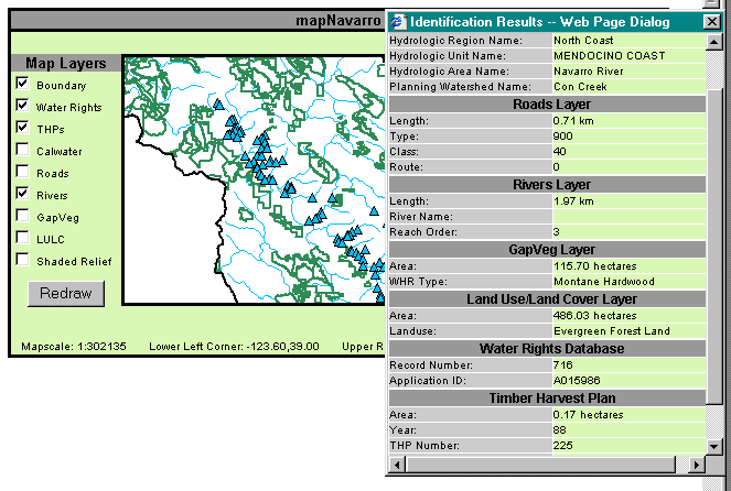
Use of the ActiveX component enables the browser with simple events that users of Windows Operating Systems expect. Namely, active pan, drag and click events are real time. This technology is implemented in three essential ways. First, it allows the user to choose geographic data sets of interest. Second, it allows the user to navigate by using inherent tools: pan, zoom in, zoom out, and full extent. Lastly, it provides the user with two mechanisms for retrieving attribute information within the GIS; this is accomplished through an Identify tool and a Hyperlink tool. These functions are readily invoked with the ActiveX control.
The Identify tool performs a “drill down” function in which information is retrieved for all data sets that are coincident with the user’s mouse click. The Hyperlink tool allows the user to initiate the ASP based data sets (see Item IV) for the Calwater Planning Watershed selected interactively. These data are passed external to the navigation window allowing for unimpeded movement and continual spatial queries. It is this last function that provides users, in this case natural resource managers, access to the summarized data content from multiple data sources in one repository. It is truly the power of a GIS in that a single data rich repository can be accessed to facilitate decision-making processes and engineered completely by spatial configuration.
Please see Appendix B for an example.
The future development of WATER, and other Internet based DSS’s, will require two items. One, there will need to be a greater emphasis on data sharing by participating agencies. And two, the further development of integrated geographic information systems into desktop applications and project management software is still a critical and mostly underdeveloped component. These two factors can be overcome in concert and we believe the WATER pilot decision support system is substantial start in this direction.
Furthermore, the continued improvement of water quality through assessment and monitoring can only be facilitated by the continued use of geographic information system technologies. As the State of California addresses the staff and funding problems associated with prior failures, it will begin to emphasize the early collection and analysis of waterbody assessment data. Thus, the single most important aspect of waterbody data accumulation and analysis will be access to central repository of such information. WATER and its associated investigation of business processes identify data critical to water quality assessment and provide an example of how a GIS can be used to facilitate water quality assessment.
|
|
|
|
|
|
|
 |
 |
Karen Beardsley, Harvey
Chinn, and James F. Quinn. 1995. California Rivers Assessment
On-Line Query System. 1995 Esri User Conference Proceedings
Karen Beardsley and James F.
Quinn. 1996. Information
Center for the Environment: Public Access to Natural Resource Data Using an
Interactive Query System on the World-Wide Web. 1996 Esri User
Conference Proceedings.
Katznelson, Revital and Mumley, Thomas. 1997. Diazinon in surface waters in the San Francisco Bay Area: occurrence and potential impact. Prepared for the California State Water Resources Control Board, The Alameda County Flood Control and Water Conservation District and the Alameda Countywide Clean Water Program.
Lehmer, Eric, Gail Lampinen, Michael C. McCoy, and James F. Quinn. 1998. ICEMAPS2 (Interactive California Environmental Management, Assessment, and Planning System Mark 2): A Map Objects based Internet Mapping Service . 1998 Esri User Conference Proceedings.
Moore, Cynthia L., James C. Mullins, Karen B. Willett, and James F. Quinn. 1999. Migrating Attributes tied to the EPA River Reach file to the National Hydrography Dataset. 1999 Esri User Conference Proceedings.
Chad D. Shook, Mary E. Madison, Karen B. Willett, James F. Quinn and Michael C. McCoy. 1999. Applied Geographic Information Systems in Cooperative Natural Resource Projects: A California Example. 1999 Esri User Conference Proceedings.
Veisze, Paul, Karen Beardsley, James F. Quinn, Joshua Viers, Isaac Oshima, and Michael Byrne. 1997. California's Experience with the River Reach File. 1997 Esri User Conference Proceedings.
Viers, Joshua H., Michael C. McCoy, James F. Quinn, Karen Beardsley, and Eric Lehmer. 1998. California Rivers Assessment: Assembling Environmental Data to Characterize California's Watersheds. 1998 Esri User Conference Proceedings.
We wish to thank the following entities:
California State Water Resources Control Board
North Coast Regional Water Quality Control Board
San Diego Regional Water Quality Control Board
Governor’s Office of Planning and Research
California Department of Fire and Forestry Protection
California Department of Pesticide Regulation
California Department of Fish and Game
City of San Diego
San Diego Association of Governments
We also wish to thank the following individuals:
Ken Harris, SWRCB
Clay Brandow, CDFFP
Bruce Gwynne, NCRWQCB
Lauren Clyde, NCRWQCB
Dave Evans, NCRWQCB
David Leland, NCRWQCB
Holly Lundborg, NCRWQCB
Bryan McFadin, NCRWQCB
Bernadette Reed, NCRWQCB
Rebecca Van Asdlan, NCRWQCB
Christina Wright-Shacklett
