
Yellow-billed Cuckoo (Coccyzus americanus occidentalis) Habitat Identification using GPS and GIS Based Survey Information
Michael R. Kunzmann, Alexander Rybak, and Peter S. Bennett
Abstract: The yellow-billed cuckoo (Coccyzus americanus occidentalis), a widely distributed inhabitant of the interior Southwestern cottonwood-willow riparian forest and the mixed broadleaf riparian forest types (Brown 1982), has become increasingly scarce in the United States. Western yellow-billed cuckoos have been petitioned for possible listing under the Endangered Species Act (1973 as amended). Habitat fragmentation, degradation of riparian woodlands, and the use of pesticides are possible causes of cuckoo decline in the United States (Hughes, J.M. 1999). Unfortunately, habitat factors important to cuckoos have not been convincingly defined (Magill 1999).
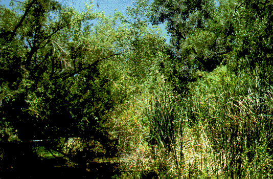
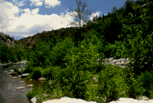
Dense broadleaf gallery riparian forests with abundant shrub understory are presumed to form an ideal habitat in Arizona. Yet cuckoos are found resident in pecan orchards and other stands that appear to be less than ideal. To delineate potential yellow-billed cuckoo habitat cost effective field data collection strategies were utilized, and GIS and modeling efforts were refined to include higher resolution spatial data and a wider array of secondary database attributes required to succinctly define habitat requirements. Geolink was critical in illustrating the shape and size of yellow-billed cuckoo habitat patches (polygons) in the field. Examination of the vegetation data collected indicates that the field methodologies are sensitive enough to delineate differences in riparian vegetation communities that change as a function of the perpendicular distance from the primary stream course.
Introduction:
The Yellow-billed Cuckoo (Coccyzus americanus occidentalis), an inhabitant of the interior Southwestern cottonwood-willow riparian forest and the mixed broadleaf forest types, has become increasingly rare in Arizona because of habitat fragmentation and degradation of riparian woodlands. As a result, western yellow-billed cuckoos have been petitioned for possible listing under the Endangered Species Act. This decision has to be supported by investigation of current bird distribution, which may be accomplished by obtaining information about habitat characteristics.
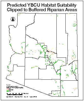
The goal of this study was to detect, delimit, and define efficient field validation techniques that could be utilized for subsequent satellite image analysis of riparian vegetation structure to delineate possible habitats for the, rather secretive, Yellow-billed Cuckoo. In 1998, historical habitat and initial field survey data were digitized, attributed, and modeled for predicted habitat preference using AVHRR imageryand GIS site stratification procedures (M. R. Kunzmann, et. al. 1999).
During the summer of 1999 we investigated floristic diversity and physiognomy of cuckoo habitats in Arizona and measured important structural vegetation components and other landscape-level factors that may be useful in delineating cuckoo habitat from non-habitat. A longer-term goal is to use vegetation structural components and satellite imagery to develop predictive models of Yellow-billed Cuckoo habitat. To determine which vegetation structural elements may be the most useful factors for predicting bird habitat we decided to collect a wide range of variables that have been traditionally used and reported in the literature as beneficial by a wide range of bird experts. Unfortunately, there is not a consensus on what vegetation parameters may be the best predictive indicators of preferred habitat because of insufficient basic ecological research on Yellow-billed Cuckoo habitat, habitat utilization, site tenacity, and other important life history factors. Because of time and funding constraints, there was also a need to develop an efficient field sampling strategy that was flexible enough to obtain the required vegetation and community measurements and that would provide the necessary data for subsequent habitat and remote sensing analysis. If vegetation structure is understood sufficiently and can serve as a surrogate factor for predicting Yellow-billed Cuckoo habitat, then it may be possible to use high spatial resolution remote sensing imagery analysis techniques to monitor changes in bird habitat over time.
Preliminary examination of vegetation data collected indicates that
the proposed field methodologies we used may be sensitive enough to depict
differences between primary and secondary Yellow-billed Cuckoo habitat
and non-habitat. In addition, the field techniques are useful to delineate
the various combinations of community floristic associations and concomitant
vegetation structural (synusia) changes as a function of the perpendicular
distance from the primary stream course in distinctively different ways.
In general, most riparian communities are not well understood (ecologically)
or sufficiently mapped at the scale required (Kunzmann, M.R. et. al., 1993).
Site Selection:
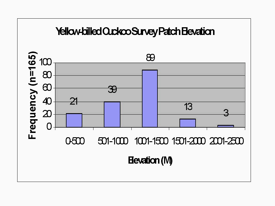
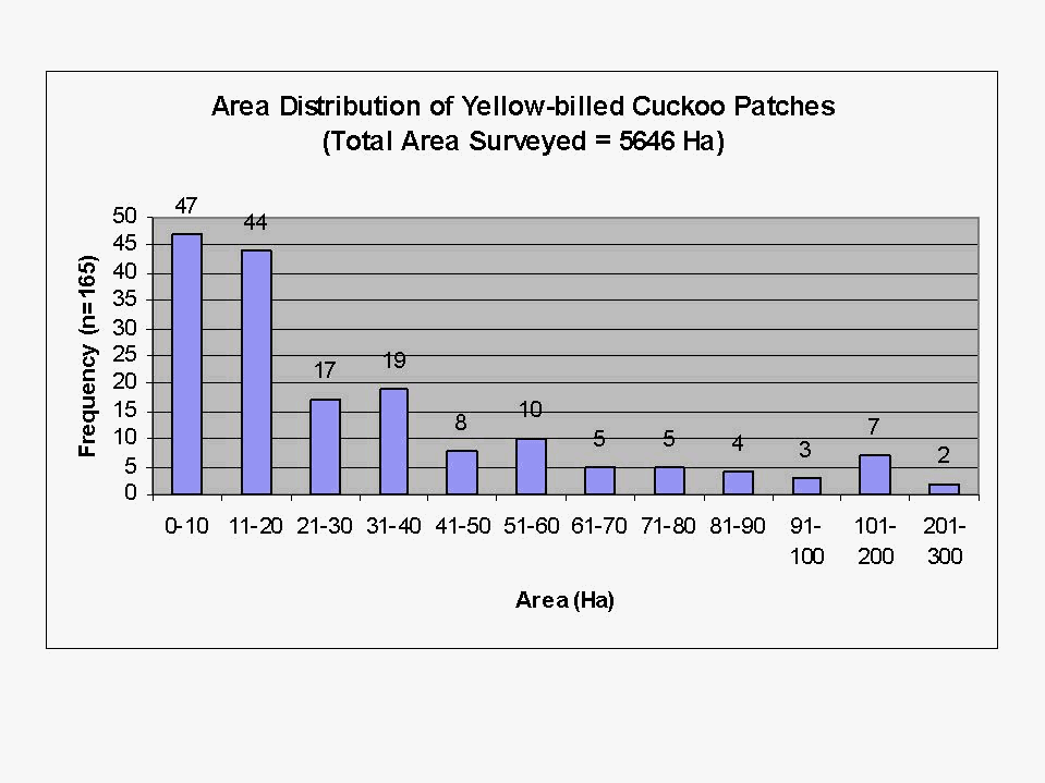
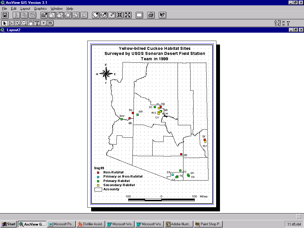
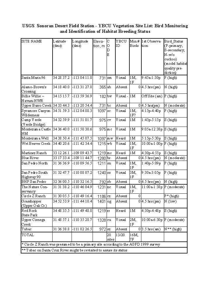
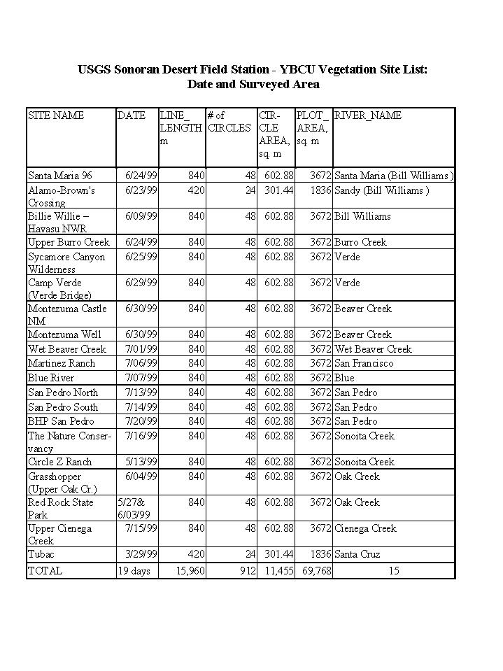
Sites (habitat patches) visited in 1998 were surveyed, digitized, and attributed by personnel at the USGS Colorado Plateau Field Station and Arizona Game and Fish Department. The early survey data and ArcInfo coverages defined the spatial extent and the polygonal area of all sites that could be used for subsequent vegetation analysis. To select individual cuckoo sites for investigation we used a stratified random sampling plan. The goal was to choose sites with different presumed breeding activity and cuckoo status, in such a way, as they would be evenly distributed in the state, cover all predicted elevation ranges, patch sizes, and vegetation communities as indicated by the 1998 survey data (ArcInfo coverages), the Arizona GAP Program habitat map (from a predicted habitat model), and possible locations as indicated by our early AVHRR imagery analysis (M. R. Kunzmann, et. al., 1999). Because of time and budget constraints, only 20 out of the original 30 targeted sites could be visited through the state. Sites with birds were classified into two categories "primary" and "secondary" based upon presumed breeding status. Sites without birds were designated as "non-habitat". Sites ranged from 180 m to 1400 m above mean sea level. At least 16 male and 7 female cuckoos (all below 1330 m of elevation) were observed when collecting vegetation measurements. Birds were seen at various times of the day ranging from 6:00am to 6:45pm. Sites represented 15 major Arizona drainages. Vegetation surveys covered almost 16 km of transect lines with 912, 4.0 m diameter, circular plots representing an area of about 11,500 m2. Because of the nature and level of detail required, the systematic transect (sampling) design, weather, and other logistic factors (not anticipated), on average, 8 hours was required per site. Approximately 4 hours were necessary to setup and read transects but 2-4 hours was often required for travel between sites.
Global Positioning System (GPS) receivers and background maps from ungenerated
ARCINFO coverages and AVHRR imagery, were used to help locate the boundaries
of selected habitat polygons in the field. Geolink GIS/GPS data collection
and mapping software (Baker-GeoResearch Inc., Billings, Montana), was extremely
valuable in helping us find difficult survey sites on back-county roads
- sites that we had never been too. In addition, Geolink was critical in
delineating the shape and size of yellow-billed cuckoo habitat patches
(polygons) in the field.
Physiognomic and Vegetation Measurements
Three different field techniques were used to characterize vegetation communities (associations) at each targeted site. Individual habitat patches within a site were identified using GPS coordinates or were identified by examining polygonal boundaries as represented by background coverages on the field laptop computer. Transect locations were randomly placed within 100m of Yellow-billed Cuckoo GPS coordinates provided by earlier bird census teams. Typically, the accuracy of GPS coordinates ranged from 4 meters to 100 meters depending upon the receivers used by field personnel and volunteer "birders".
The vegetation measuration techniques selected were:
Primary analysis was done for the sites, which were subdivided into three major types:
Preliminary Results:
A majority of assumptions about yellow-billed cuckoo habitat requirements were derived from observations made by a wide range of people ranging from highly trained ornithologist to hobbyist "bird watchers", who conducted a variety of systematic and non-systematic studies of limited duration. Most studies did not focus on vegetation structure as the primary analytical goal nor were most studies interested in characterizing the vegetation community in such a way that field information collected could be used by the remote sensing specialist to predict and detect site habitat changes. Earlier studies indicate that for the yellow-billed cuckoo the following habitat features may be significant or at least be somewhat preferred characteristics:
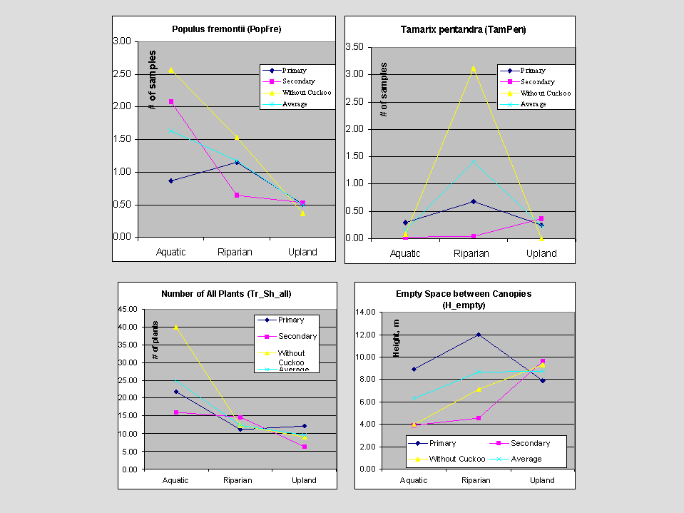
Species richness, number of all plants stems, and "empty space" sampling unit statistics are also interesting factors to examine trends across Yellow-billed Cuckoo sites. Please note that the species richness and empty space are not directly correlated across all habitat types.
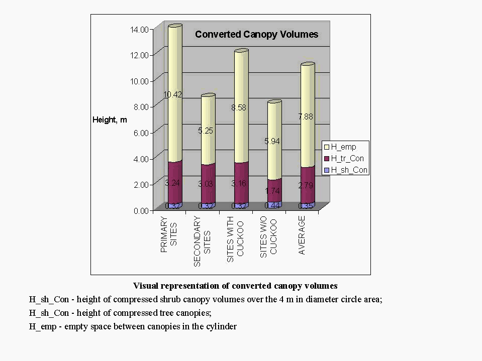
In addition to transect variables such the number of trees and shrubs, the height of trees and shrubs, stem counts, and other primary data derived directly from cylinder sampling units there are a number of derived variables that show promise. In addition, these derived variables permit better visual representation and interpretation of vegetation structural difference between sites. Two of the derived variables converted canopy volume and synusia vegetation structural coefficients may serve as an illustration of integrating variables that are somewhat predictive of yellow-billed cuckoo habitat groups stratified across site and riparian community types. A preliminary summary of variables that may be used to depict differences between primary, secondary, and non-habitats was examined.
Upon examination of all variables, floristic and structural differences could be detected between the sites with and without yellow-billed cuckoos. From a derived statistical profile (representation) of each significant variable grouping "type" sites can be illustrate by constructing a "generalized" schematic of the vegetation structural differences that are indicative of our sites and between habitats. Sites with cuckoo have larger total canopy volume, larger tree canopy volume, but smaller shrub canopy volume. Trees here are taller, but shrubs are shorter. Sites with cuckoo have smaller number of all plants, almost the same number of trees, but much fewer shrubs. So, every tree on a site with cuckoo has larger canopy, but every shrub has smaller canopy, and tree cover is bigger, but shrub cover is smaller.
Synusia structure is completely different:
sites with cuckoos in layer A (0.25m -2m) have more plants (7.4 vs. 6.8);
in layer B (2m-8m) - much less plants (5.5 vs. 13.4); in layers C (8-30
m) and D (higher than 30 m) significantly more trees (1.1 vs. 0.7 and 0.12
vs. 0.01 respectively). These differences are also supported by a derived
synusia coefficient (1.25 vs. 0.31). However, sites with cuckoos have fewer
plants higher than 2.0 m (6.7 vs. 14.1), so basal area is smaller, but
the empty space between canopies is larger. Vegetation structure may be
a more universal analytical tool for predicting possible bird habitats
across geographically broad areas of the state because of differences found
in floristic provinces within Arizona. Riparian species which may be utilized
by yellow-billed cuckoos do not occur with equal frequency across the state
for many reasons - some ecological and others anthropogenic. For example,
occasionally, birds have been observed in orchards near historic riparian
habitat that has been reduced, modified, and in some cases eliminated.
Habitat structural characteristics, on a comparative basis to floristic
variables based on the identification of specific species, require less
training and are easier to collect reliably year round. In addition, changes
in vegetation structure may also be detected by remote sensing techniques.
Appropriate measurement resolution and spatial scale are critical factors
that must be examined to coordinate field and remote sensing activities.
Future Research Required:
The next phase of our research will be to use our twenty field sites as remote sensing "training" sites so we can examine which combinations of imagery and analysis techniques may be used predict possible habitat. Current efforts are underway to reexamine how our field-based measurements of vegetation structural, community structure, and other ecologically important habitat parameters may be integrated with a wide variety of spectral data, imagery products, an remote sensing analysis techniques. For example, Lidar, is an established remote sensing technology that is commonly used to obtain accurate, high spatial resolution, measurements of surface elevations from airborne and Space Shuttle platforms (Krabill et al 1984, Bufton et al. 1991). However, one of the more interesting applications of Lidar technology was recently published by M.A. Lefsky et. al. (1999). It was pointed out in the article that the SLICER (Scanning Lidar Imager of Canopies by Echo Recovery) could characterize multiple canopy elements (foliage and woody vegetation structures) in a 5m to 25m diameter area. This spatial scale fits well with traditional field-based measurement techniques. In addition, unlike traditional microwave and optical sensors, lidar sensors directly measure the distribution of vegetation components along a vertical axis and can be used to provide three-dimensional and volumetric characterizations of vegetation structure. If these techniques (after standardization and localized calibration) could reduce the number of ground-based measurements required per site to predict yellow-billed cuckoo habitats, then it would be possible to expedite inventory and monitoring programs necessary to predict bird distributions and develop better habitat protection plans.
However no matter how well we are able to measure site vegetation structures
or catalog floristic data, the yellow-billed cuckoo will be at risk unless
more long-term ecological investigation are initiated to determine specific
habitat requirements. Many aspects of yellow-billed cuckoo ecology have
not been adequately investigated. Long-term, multi-scale, integrated, multi-disciplinary
research are needed to address basic life history questions. Time, energy,
and habitat utilization studies should be a high priority for anyone interested
in protecting cuckoo habitat. More research is also required on migratory
routes and dispersal mechanisms which are virtually unknown. Optimistically,
GIS, GPS, spatial-based analytical tools, and remote sensed imagery techniques
may provide a means for ecological insight. However, without consistent
long-term funding it is doubtful that significant ecological advances can
be made to adequately understand why western populations of the Yellow-billed
Cuckoo have been declining dramatically.
Acknowledgements:
Literature Cited:
Bennett, P. S., M. R. Kunzmann, W. Halvorson. 1998. Manual for the GAP program: collecting vegetation classification data. USGS BRD Cooperative Park Studies Unit. The University of Arizona, Tucson, AZ. In review.
Bent, A. C. 1940. Life histories of North American cuckoos, goatsuckers, hummingbirds and their allies. Dover Publications.
Bufton, J.L., Garvin, J.B., Cavanaugh, J.F., Ramos-Izquierdo, L., Clem, T.D. and Krabill, W.B., 1991. Airborne lidar for profiling of surface topography. Opt. Eng. No. 30. P. 72-78
Corman, T.E. and R.T. Magill. 2000. Western yellow-billed cuckoo in Arizona: 1998 and 1999 survey report. Nongame and Endangered Wildlife Program Technical Report 150. Arizona Game and Fish Department, Phoenix, AZ.
Gaines D.A. and S.A. Laymon. 1984. Decline status and preservation of the yellow-billed cuckoo in California. Western Birds, No. 15. P. 49-80
Gaines, D. 1974. Review of the status of the yellow-billed cuckoo in California: Sacramento Valley populations. Condor, No. 76.
Halterman M.D. 1991. Distribution and habitat use of the yellow-billed cuckoo (Coccyzus armiericanus occidentalis) on the Sacramento River, California, 1987-1990. MS Thesis, California State University, Chico, CA
Hughes, J.M. 1999. Yellow-billed cuckoo (Coccyzus americanus). In The Birds of North America, No. 418 (A. Poole and F.Gill, eds.). The Birds of North America, Inc., Philadelphia, PA.
Johnson, R.R. and C.H. Lowe. 1985. On the development of riparian ecology. In Riparian ecosystems and their management: Reconciling conflicting uses. First North American Riparian Conference. April 16-18, 1985. Tucson, AZ.
Krabill, W.B., Collins, J.G., Link, L.E., Swift, R.N. and Butler, M.L., 1984. Airborne laser topographic mapping results. Photogramm. Eng. Remote Sens. No. 50.
Kunzmann, M.R., P.S. Bennett, and R. R. Johnson, (1993). Riparian Ecosystems: Values and Functions. In Altered, Artificial, and Managed Wetlands Focus: Agriculture and Forestry, the Proceedings of The Association of State Wetland Managers, Berne, New York.
Kunzmann, M.R., R. J. Hobbs, C. S. A. Wallace, and S. E. Marsh. 1999. AVHRR imagery analysis and habitat modeling as planning tools for conducting yellow-billed cuckoo (Coccyzus americanus occidentalis) surveys in Arizona, In The Nineteenth Annual Esri User Conference 1999. June 26-30, 1999. San Diego, CA.
Laymon, S.A. 1998. Partners in Flight bird conservation plan: Yellow-billed Cuckoo (Coccyzus americanus). Administrative Report to California Partners in Flight.
Laymon, S.A. and M.D. Halterman. 1987. Can the western subspecies of the yellow-billed cuckoo be saved from extinction. Western Birds, No. 18.
Lefsky, M.A., G. G. Parker, T. A. Spies and D. Harding. 1999. Lidar remote sensing of the canopy structure and biophysical properties of Douglas-fir western hemlock forests. Remote Sensing of Environment. Vol. 70, No. 3.
Magill, R.T. 1999. Study plan: Distribution and habitat use of the western yellow-billed cuckoo (Coccyzus americanus occidentalis) in Arizona. Nongame and Endangered Wildlife Program, Nongame Branch, Wildlife Management Division. Arizona Game and Fish Department, Phoenix, AZ.
Rea, A. 1983. Once a river. University of Arizona Press. Tucson, AZ.
Shelton, A.C. 1911. Nesting of the California cuckoo. Condor, No. 13.
Warren, P. L., K. L. Reichardt, D. A. Mouat, B. T. Brown, and R. R.
Johnson. 1982. Vegetation of Grand Canyon National Park. Technical Report
#10, USDI, National Park Service Cooperative Park Studies Unit, Tucson,
AZ.
Author Information:
Michael R. Kunzmann is an Ecologist at the USGS Sonoran Desert Field Station which is located within the School of Renewable Natural Resources. The School of Renewable Natural Resources is in the College of Agriculture and is centrally located on The University of Arizona campus. Correspondence may be addressed: Michael R. Kunzmann, USGS Sonoran Desert Field Station, The University of Arizona, 125 Biological Sciences East, Tucson, Arizona, 85721. Mr. Kunzmann may also be reached by telephone at (520) 621-7282 or by email: mrsk@sherpa.srnr.arizona.edu.
Alexander R. Rybak is an Associate Researcher at the USGS SDFS, an exchange scholar at the School of Renewable Natural Resources at the University of Arizona, and a Landscape Ecologist at the Ukrainian Academy of Agrarian Sciences - National Botanical Gardens. Correspondence may be addressed: Alexander R. Rybak, C/O USGS Sonoran Desert Field Station, The University of Arizona, 125 Biological Sciences East, Tucson, Arizona, 85721. Mr. Rybak may also be reached by email: ryback@excite.com.
Peter S. Bennett is an Ecologist at the USGS SDFS which is located within
the School of Renewable Natural Resources. The School of Renewable Natural
Resources is in the College of Agriculture and is centrally located on
The University of Arizona campus. Correspondence may be addressed: Peter
S. Bennett, USGS Sonoran Desert Field Station, The University of Arizona,
125 Biological Sciences East, Tucson, Arizona, 85721. Mr. Bennett may also
be reached by telephone at (520) 670-6886.