Wei-Yuan Lo(1)�ELan-Kun Chung(2)
The development of Internet has a great effect upon GIS. It is a trend to combine GIS with Internet, but there are many restrictions to practice the basic GIS functions (to combine spatial data and attribute data) on WWW. For this reason, when 3D GIS can present GIS��s function completely , it would be more real and clear to describe the space.
When 3D GIS which combine 3S (GIS �BGPS �BRS) through the function of WWW , can provide the completely information to be analyze for building , and can get the most correct building information in shortest time when the calamity happened in city , and can also assist the aid and rebuild mission .
This research use the tools which are ArcView GIS and VRML to build up the 3D GIS , and also build up a system which can present building structure quickly . They also provide the functions and can use in against natural calamities �Brelieve natural calamities and rebuilding.
3D GIS, GPS, RS, CAD, VRML.
When the desktop GIS has to extend to internet , how to use the present resource and technology into internet directly , and study the way to build up 3D GIS , and also can let the 2D data in ArcView GIS become real world��s 3D GIS data.
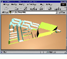
When we transfer the present ArcView GIS 2D shapefile to the VRML format and use in WWW , the 2D data will be given the elevation value or the value on behalf of high during the transformation. And can display in internet for user to browse as 3D type.
It is very important thing for GIS to combine attribute with object. It is difficult to transfer 2D date to 3D data and can keep the attribute date combine with spatial object. Thus , we have to have good basic of VRML and webpage language.
In using data actually, the benefit and demand of Internet are much bigger than the un-Internet environment ; especially the Internet provides the immediately function and let resource can limited extend its using and applying , and also can increase the benefit. Therefore , it is one of main research direction and application goal to using 3D GIS in Internet.
In the field of GIS, ArcView has completely basic function and getting perfectly , especially after add the analyze function which provide by Extension Model. However, to general users, it is unnecessary to have such a complicated function. Perhaps the users only need a GIS which can display real world completely and actually, and can get the GIS��s spatial data and attribute data immediately through WWW. Furthermore, users feel boring of 2D GIS data, and think it is unable to virtual the real world.
Therefore, we have to apply the original 2D GIS data to 3D GIS data, and through the spread of WWW to make users get the most real and complete 3D GIS information.
In PC environment, ArcView provide the best GIS solution , especially the analyze function of 3D , it can let GIS getting closer to real world and display spatial and attribute relationship completely.
In WWW environment, ArcView has to build under ArcView IMS, but the ArcView IMS has too heavy loading for server, and not so suitable to go for analyze function in WWW immediately.
In ArcView��s 3D model , can export the finished 3D subject base on VRML 2.0 format , and then display the 3D subject by VRML browser. VRML export formula which provide by ArcView can help the development of 3D GIS in WWW, once user with VRML browser, they can browse 3D GIS through by WWW, but the only regret is cannot find out the attribute data.
It is not a concept suitable for all data to transfer the 2D spacial data to 3D spacial data. For example, the control point which present by spot type is not suitable to display by 3D object, and it has the same property of thread type display by fault map.
However, in the data type of GIS, provided elevation value data is the best suitable to transfer from 2D type to 3D type, and also suitable for users�� demand and application value. For example, when we observe the city plan map, we only can see each using type of living area or industry area through ArcView, and cannot understand each area��s landscape type.
It is the most basic concept to connect spacial data to attribute data in ArcView, so, it must has the same concept that 3D data build up from 2D data. The theme that built by ArcView 3D model can connect the spacial data together with attribute data, but the users that besides ArcView cannot use 3D data.
Using the VRML 2.0 export function which provide by 3D model, 3D themes build up by ArcView 3D model can browse and operate by browser, and let themes present different screen vision, but cannot know what the attribute is. Because of the VRML data that export by 3D is a theme and an object, is different present way with the feature and an object from ArcView, and cannot connect with attribute data.
The most effective and speed way of information spreading is Internet, and it also is the one of best way to display GIS by WWW. To present WWW webpage has to through by WWW browser, in another word, we have to build up WWW website to provide GIS information in internet effectively.
However, we have to consider the data size when we present GIS by WWW, and the VRML��s 3D GIS data size also very huge in internet . There is direct proportion relationship between data size and feature object number.
Base on the data of ArcView, we translate the 2D data to 3D data by VRML, and issue the result by web page. As VRML has provided with the conditions of transmission and presentation, once we can conquer the connection of attribute data, we can have the elementary function of 3D GIS.
Besides of VRML plus HTML, we have to consider the data of CAD, the first reason is the ArcView has the ability of present CAD data, second reason is many building data keep by CAD system.
As VRML to be the solvent for 3D GIS, we should understand VRML first; it includes the structure of VRML, developing direction and ability. Next is to aimed at the research of VRML, we only need to take out the ability of 3D GIS structure, and can reduce the complication and quantity of data of 3D GIS.
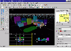
During the process of research VRML, we use some assist tools. The first is to present the built object by Cosmo player, the second is to understand the structure of VRML syntax and property by Cosmo Worlds.
Because of translate the ArcView data to VRML format, we need to understand the data format of ShapeFile in ArcView. After we understood the data format, design the translate program base on ArcView's Script language -- Avenue, and let ArcView ShapeFile data convert to VRML data.
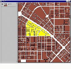
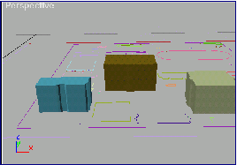
ShapeFile format description: for Polygon format, the main thing is to understand the building principle of each feature. For example, a polygon, the end point coordinates value sequence from one to five is {(X0, Y0), (X1, Y1), (X2, Y2), (X3, Y3), (X4, Y4)}, but the record in ShapeFile is {(X0, Y0), (X1, Y1), (X2, Y2), (X3, Y3), (X4, Y4), (X0, Y0)}, thus, it has to repeat the start and end point in the latest step, to let whole surface to be a closed situation.
Designing process: To analyze ShapeFile file and property data ---> use Avenue to finish 3D object file, property file and webpage file ---> to collect the builded files in one homepage. ( Here we suppose Avenue and HTML have provided base condition.)
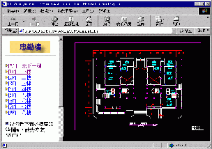
If we only build up simple 3D GIS and it can be used on WWW, the above process has already done. But if we want to use for building analysis, we have to add the ability of CAD data presentation. Users not only can receive 3D building outlook, but also understand property. The most important thing is to understand the whole building structure mood, thus we have to depend on CAD data.
There is a free tool (Whip!) from AutoDesk Inc., it can support users to see the Remote Point CAD data through by WWW, and with the basic view drawing function of AutoCAD��s zoom in, zoom out and move. To collect the tools into 3D GIS, and then it offers more completely information and makes the resource be used more completely. During the process of collection, because ��Whip!�� can only accept Internet format, we have to transfer the original AutoCAD (.dwg) format to (.dwf) format for Internet use. Next, to collect the
As Feng Chia University for example, divide research result into two parts: 3D GIS structure and user operation.
Get the plane drawing of Feng Chia University and each buildings�� structural drawing (CAD), build up completely school building information in ShapeFile, and transfer to (.dwf) format in CAD part.
Following the above research method to analyze each building��s data structure and get the property, transfer ShapeFile to VRML file with Avenue, and collect HTML, property data and CAD data to be homepage.
Put finished Avenue web page in WWW server and announce to public. As the WWW system flattop is different, the server set up has to following the type of flattop. At present, our research is base on NT system and combine with IIS to be WWW server.
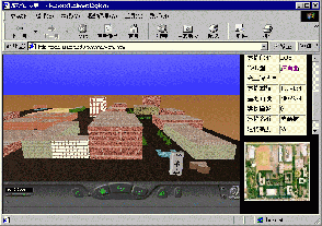
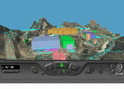
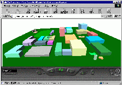
After users record into homepage, they have to install two formulas: Cosmo Player and AutoDesk Whip! . These two Pulg-In formulas offer VRML browse function and CAD browse function.
After setting up Cosmo Player and AutoDesk Whip! , Users can browse a fictitious Feng Chia University from the browser. By the below control desk, users have different browse to Feng Chia University. When they click each building, they will get the building��s property data. If users click the building floor, they can connect to CAD part and present on Web page.
Now the research is only a beginning. For further manipulation with VRML and homepage formula design, the whole homepage inter face would be more and more perfect and flexible. It can connect with other fields�� development on application level.
As Earthquake Calamity for example, the first 36 hours after calamity happened is the best time for first aid. People who been hurt and been besieged have higher chance to alive. However, the aid process will be effected by damaged building, and the less understand for building structure will effect the aid slowly and uncorrected.
The aid people can get the calamity location and building picture through GPS and send back to aid control center with the function of Rapid Building Analysis. And the aid control center can follow the coordinate get building location and analyze the structure, then send back the information to disaster scene by internet.
Under a urban planning, large construct and development will destroy the natural environment, and become the calamity, as landslide, debris flowing, and etc. After combining with RS aerial image data, it can simulate the situation of before and after development how the topography damaged and how building will be after natural calamity.
Wei-Yuan Lo(1)
(1) Systems engineer of GIS center, Feng Chia University
Lan-Kun Chung(2)
(2) Manager of R & D Division, GIS center, Feng Chia University