Story County, Iowa updates its land use plan every five years. The creation of critical resource areas for the land use plan integrates soil productivity, flood frequency, slope and vegetation to name a few variables. This process took weeks gridding a 576 square mile county in 1993. In 1999 GIS allowed similar modeling to be done in a matter of hours. Each process will be summarized to show how even simple GIS modeling can increase productivity.
Story County, Iowa is located in the central region of the state. It covers 576 square miles with sixteen townships. All or part of fifteen incorporated cities are located in the county, with populations ranging from 47,632, the population of Ames, to 305, the population of Sheldahl, which is only partially located in Story County. The population for the entire county is estimated to be 74,875 by the Bureau of the Census.
In 1993, Story County completed a combination of three studies completed in 1977. The newly created County Development Plan’s (CDP) goal was to “establish guidelines and locations for areas of growth, growth stabilization, agricultural land preservation and environmental resource protection”. The review period written into the 1993 plan was for updates every five years, and the current review period began in the summer of 1998.
There are five major categories on the CDP map: Residential, Commercial, Industrial, Agricultural Residential, and Critical Resource Area (CRA). Some of the above categories are divided into sub-categories. Residential, Commercial, and Industrial areas are determined by existing growth patterns and which can be helped by Geographical Information Systems (GIS) modeling, but were not at that time.
Agricultural Residential areas are “undeveloped areas of low-to-moderate value agricultural land or areas which may be considered as logical extensions of existing development”. All of the agricultural residential areas on the 1993 plan map are located adjacent to incorporated areas. For the current plan update, GIS will be used to help identify areas which are the most suited for rural residential development.
The final category, Critical Resource Areas, will be the main focus of this paper. In 1993, criteria was created to determine what factors should be considered in the creating of a CRA. Five separate variables were scored to create the classification for the CRA’s: hydrologically sensitive areas, vegetation, flood plain, septic suitability of soils, and building site development suitability.
In 1993, all data used was in a paper format through varies sources, but none of it was available in a digital format. This made creating a grid to cover the entire county a long and time consuming process. The following process was manually done by two interns, consuming an estimated 300 person-hours.
A transparency was made of the base map. On this, a 10-acre grid was drawn over the study area. Each resultant cell was labeled a-h from west to east and 1-8 from north to south for each section. The letters and numbers varied due to the different sizes of each section, however 1A always occurred in the upper left-hand corner of the section. This grid map was the basis for tabulating CRA scores.
Each mapped resource element was then overlaid with the grid map. For each 10-acre cell, points were assigned if a resource element covers at least 50% of the cell. The scoring system is listed in Figure 1.
RESOURCE ELEMENT |
WEIGHT |
POINTS |
MAX. WEIGHTEDTOTAL |
|
Hydrologically Sensitive Areas |
3 |
2 |
6 |
|
Vegetation: Scattered Large Trees Woodland |
3 |
1 2 |
3 6 |
|
Flood Plain: Floodway Fringe Floodway |
3 |
1 2 |
3 6 |
| Soils: Septic Suitability | 2 | 2 | 4 |
| Soils: Building Site Development | 2 | 2 | 4 |
(Note: Each element is almost identical for the 1993 and 1999 studies, but differences will be noted later in the paper)
This element is rated high due to the possible pollution factor to the alluvial aquifer. The scoring range is zero or six with a cell containing 50% or more of severity of this element being assigned a six.
The cells were determined as to the coverage by large scattered trees or woodland. Fifty percent or more of large scattered trees rated a three, fifty percent or more of woodland rated a six.
Each cell was scored a three if 50% or more was withing the floodway fringe and a six if within the floodway. If the cell was assigned a six, no further delineation of the cell was done as development is prohibited in the floodway.
This element was placed in this category even though many soils have severe limitations for traditional septic systems. These limitations can be overcome by alternate disposal systems. A cell which demonstrated a severe limitation was assigned a score of four.
This element illustrates severity of the soils for building development with basements. Severity of limitations can be overcome with construction methods. A cell with a severe limitation was assigned a four.
Notebooks were created to document the entire process of overlays and scoring of the elements. Over 500 pages of data was created and are stored in four three-ring binders. After all elements were completed, the weighting was added and a final value was determined, which was then grouped into one of three classifications: High, Moderate or Low area of concern (Figure 2).
|
CLASSIFICATION |
POINT RANGE
(MAXIMUM WEIGHTED TOTAL) |
|
Resource Areas of Highest Concern |
12-26 |
| Resource Areas of Moderate Concern | 8-11 |
| Resource Areas of Least Concern | 0-7 |
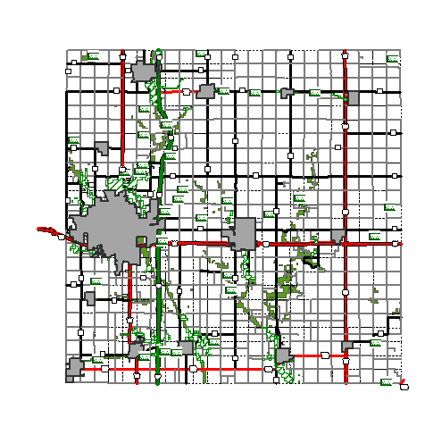
The finished product is shown in Figure 3 with a map of Story County, Iowa and the Critical Resource Area (CRA) overlayed in green.
As GIS has become more affordable and advanced, desktop GIS programs allow analysis to be done in a fraction of the time it takes by hand. ArcView GIS with Spatial Analysis created the opportunity for what-if scenarios to be created by allow the software to do all of the computing. The same five elements used in 1993 were used in 1999 to create a Critical Resource Area map of Story County. Some of the elements were modified so digital data could be used.
The 100 year and 500 year floodplain determinations were used from the digital Q3 data from FEMA. Previously floodway and floodway fringe data was used. The 100 year floodplain designation falls in line with county zoning regulation which do allow any construction within the 100 year floodplain.
A 1996 raster landcover map was used to determine where forests and grasslands occurred. This is a change from 1993 when aerial photos were used to determine where large scattered trees or woodlands were located.
All three of these elements are available from digitized soils data which was taken directly from the paper copies. Our soils information was rectified to public land survey markers to increase its accuracy. Sensitive areas were determined to be the areas with the most permeable soils and the suitability ratings were created by the Story County Sanitarian.
Spatial Analyst made it possible to create the base data in a matter of hours, not weeks. This base data was then manipulated to see how different scoring scenarios would affect the Critical Resource Area map. The map calculator was used to change the weighting scheme in each scenario. Now, Model Builder removes the need to manually change the equation and allows the user a graphical interface to change the model. Accuracy has also increased and errors have been reduced by using GIS. Smaller sensitive areas can be identified by using a 50 foot pixel versus the 660 foot pixel used in 1993. Figure 4 shows errors that are introduced by using the larger pixel size. The green identifies the 1993 CRA while the red shows the 1999 CRA (The creek is represented by the blue line).
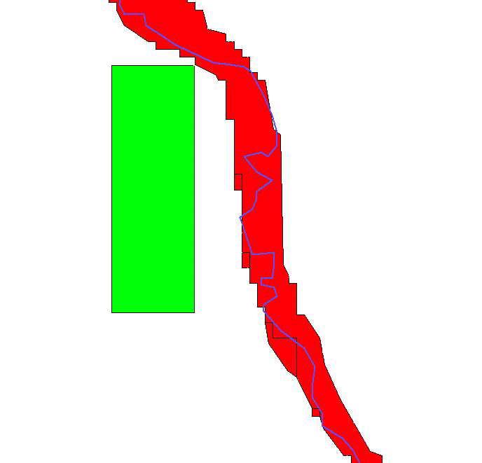
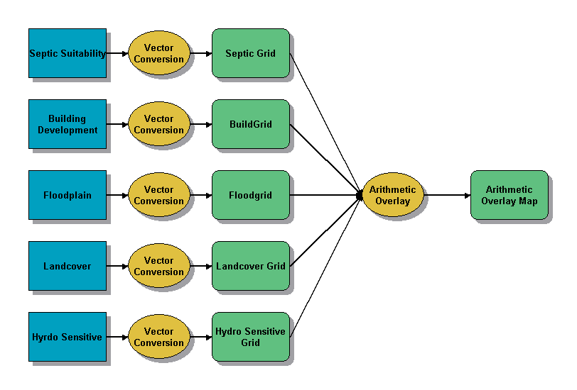
Figure 5 shows the flow chart taken from Model Builder to visually depict the processes used to create the CRA’s. It is a very simple model with the only processing of the data itself is processing the vector data into grids. The grid data can then be assigned a value because all of the data used are integers, so it is viewed as discrete.
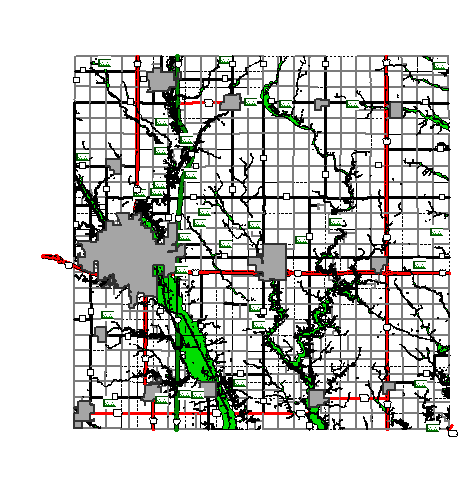
Scenarios are created by changing the arithmetic overlay values. Figure 6 shows the newly created Critical Resource Areas, which uses the same values as the 1993 set does but the changes reflect data differences, especially the 100 year floodplain.
Creating the new Critical Resource Areas was just the first step in using Spatial Analyst in the updating of the County Development Plan. The next important step that GIS will help is the creation of rural development areas that will help focus new construction near cities and help reduce sprawl. Initial scenarios include such elements as crop suitability ratings, distance to city limits, and distance to paved highways.
The use of spatial analysis has created the opportunity to perform time consuming analysis at lighting speed with the use of GIS. More scenarios and options can be created and studied by the decision makers and hopefully the most productive and useable solution will be chosen.Story County, Iowa, Planning and Zoning, County Development Plan, 1993
Story County, Iowa, Planning and Zoning, County Development Plan Background Report, 1993
Story County, Iowa, Planning and Zoning, Groundwater Protection Plan, 1991