The paper presents the integration of GIS support with a network analysis software package named GREDOS. At the first approach the package has been implemented as an ArcView GIS 3.1 extension. The new version of GREDOS is based on Esri's MapObjects ActiveX technology. The paper describes both approaches and compares advantages and disadvantages by means of programming effort and efficiency of software solution. The package is successfully implemented in Slovenian distribution utilities.
The new tasks and changes, such as new institutional arrangements, opening the electricity market, environmental restrictions, and adoption of new technologies, should by all means be in any respect taken into consideration at the setting up of strategic development planning principles and to assure reliable operation of the distribution network. It is a prerequisite that the methodological and technological development of electric power systems is closely followed, and that program tools and electric power system planning methods are constantly improved as foreseen on the basis of development studies. The probabilistic approach to the planning and the operating analysis have turned out to be of a paramount importance as far as the company�s cost efficiency and achievement of the quality level of the consumer supply are concerned.
The following are the factors that have a global impact on the planning process for the distribution system:
- Rise in the electricity consumption,
- Spatial and environmental restrictions,
- Organization of the electricity supply industry, market opening, and
- Reliability and quality criteria.
The Slovenian distribution system consists of five regional distribution utilities that permanently perform long-term studies of the network development.
The target of the project was to provide the basis for a permanent study in the development of the distribution network and software package tools. With regard to the same planning criteria and external conditions governing the utility operations, a complete long-term development plan for one utility is made each year. On the basis of such approach, each utility is being considered within a cycle of five subsequent years. A 30 years lasting period is being planned. The initial emphasis will be laid on investments to be considered in the first five years. The planning system is decentralized with the criterion aimed at the optimal development of each utility. Advantages of the common project for the five utilities are cost-effective financing, common development interests and common software development for the needs of the Slovenian distribution system.
Gredos is a tool used for planning electric power systems. Development started in early 90s as a FORTRAN program that did calculations on data that was stored in text files and put the results in another text file. Later on calculations from that program were ported in C and graphical user interface was added. Operating system still remained MS DOS. The graphical representation of the network was put in separate file in non-standard proprietary format. Those were quasi-spatial data. Graphical layouts couldn't be imported in any commercial programs (i.e. Word, AutoCAD). The need for standard formats arose and standard GIS tools were chosen. Esri tools were accepted because great part of the government uses Esri software.
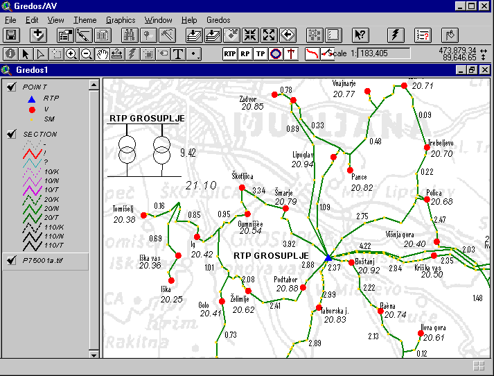
ArcView 3.0 was selected as the platform for transition to GIS and Windows world. Gredos/AV was realized as an ArcView extension (AVX) and additional dynamic link library (DLL) with analysis functionality and forms for data entry. DLL that was developed in Visual C++ was necessary while analytical functions were too complex to rewrite them with Avenue. Source code from GREDOS for the calculations remained almost untouched in Gredos/AV.
At the time when Gredos/AV was starting (1998) GIS was not present in Slovenian distribution system and there was no spatial data that users could use for analysis. That was the reason why engineers used Gredos/AV for data entry.
Through the development process many disadvantages appeared.
- Development of Gredos/AV was very tedious while there were two development environments (ArcView and Visual Studio), two different languages (Avenue and C++). When an error occurred there were often doubts whether the cause was in ArcView or Gredos DLL
- User interface is efficient but complex
- Huge project sizes. A project with 2000 nodes and 1000 sections took more than 6MB
- Too many files needed for single project,
As so many limitations have appeared during development process decision was made to port Gredos in a more flexible environment. MapObjects were chosen as the GIS component for the application.
Gredos/MO is standalone program based on MapObjects. It includes almost complete functionality from Gredos/AV and more.
Gredos/MO consists from five connected modules:
- Project
- Project Manager
- Data Manager
- Analysis
- Renderer
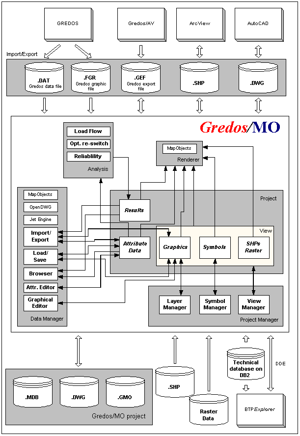
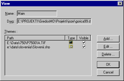
Each project consists from attribute data, view(s) and results. Each part of the Gredos/MO project (except results) is stored in separate file. Attribute data is stored in MDB database; graphics in DWG file and views are stored in GMO file. MDB and DWG are standard formats. GMO is text file that store all data about project that is not stored in MDB or DWG.
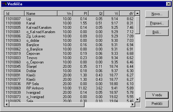
There are five tables in the MDB database:
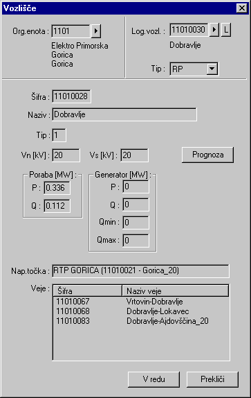
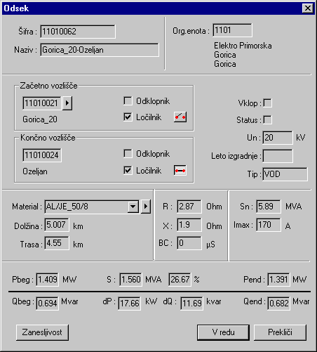
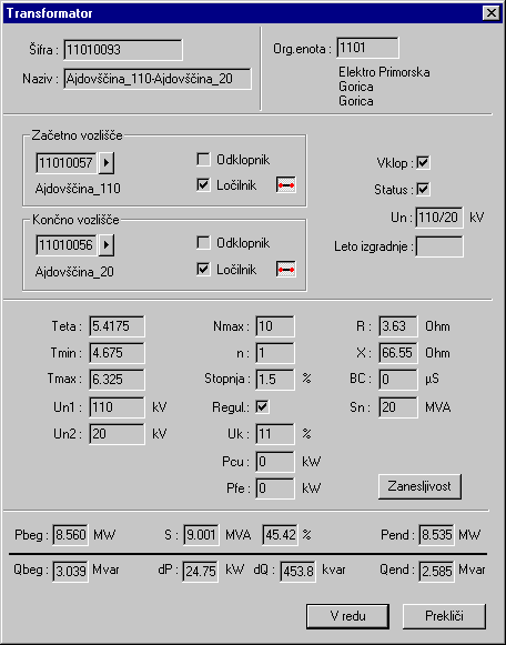
- Node
- Branch
- Section
- Transformer
- LNode
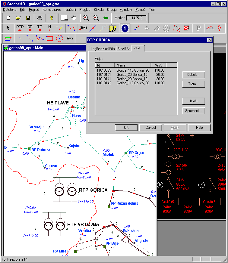
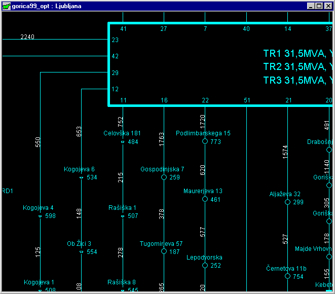
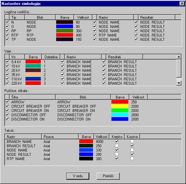
Nodes are connection points. Branches are lines that connect nodes. Branch can be section (cable) or transformer. LNodes are compound points that contain simple nodes and branches that connect these nodes. Only logical nodes and sections can be display on the map.
Results contain results of the analysis.
View contains information how to present data and results.
Same attribute data and results can be show in different views. There are two types of views: geo view and schematic view. The difference between geo and schematic views is that schematic views don�t have maps on the background. Esri Shapefiles and raster data can be put on map.
A project can have many views opened at the same time.
Graphics contain any graphical element that can be put in the drawing.
Sections are represented as polylines, logical nodes as external blocks, names and results as texts. All graphics are stored in DWG file.
Why was DWG format chosen for storing spatial data instead of Esri Shapefile? As well as displaying network elements (nodes and lines) Gredos/MO renders additional graphics such as results and schematics. Storing such data in Esri Shapefile would be very tedious.
Entities in DWG are connected with attribute data through extended data.
Symbols describe how to render graphical elements that are connected to data and results.
More than one project can be opened simultaneously.
Many projects were made with Gredos/AV and an effort was made to make it possible to import all those projects in Gredos/MO.
While the graphic editor build in Gredos/MO is not so powerful as those in other programs for data entry there is a possibility to draw network in other programs and import it Gredos/MO. This functionality is widely used while there is enormous quantity of schematic drawings in form of DWG files.
The employed mathematical modules were designed in accordance with the most recent achievements. The relevant calculations are extremely fast. There are no restrictions on the network size. All modifications and calculations are run in the graphic environment. The AC module for the power flow calculation enables modeling of generation sources in the distribution network, transformer voltage control evaluation and more useful options for planning processes.
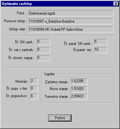
The optimal sectioning of the MV network follows the minimum loss criteria or the adequacy criteria on the most favorable network reliability structure. The program enables an interactive approach and analyses of alternative solutions over various criteria. In the fault analyses, data are automatically created from the PF network data and additional data from the database. Several fault types analyses are available.
The reliability analyses module enables calculation of reliability indices of distribution networks in the same graphic environment. Indices used to evaluate adequacy of the customer supply are:
- Average interruptions frequency (F),
- Average interruptions duration (T),
- Expected annual interruptions time (H=FxT),
- Interruptions cost.
The system index of adequacy E is defined as an expected average not supplied energy considering any failure that might occur in the network.
Besides the capacity of network elements, the model considers constraints of the radial operation of meshed built networks. At each failure, the model eliminates the failure component and calculates a new radial state by reswitching. The new radial state can be sufficient or insufficient for a particular demand. With such calculation, the reliability judgment and different investigations of the network development in a wide range of conditions are thus made possible.
Task of the renderer is to display graphics on the screen or printer.
Data editing, browsing, storing and retrieving are the tasks to be done by Data Manager.
Gredos/MO is completely developed in a single environment: Visual Studio 6.0. Instead from previous version (Gredos/AV) only one programming language was used: C++. Microsoft Foundation Classes were used as the framework and for access to the database.
For reading and writing DWG files OpenDWG library was used.
There are three tasks where MapObjects 2.0 is used. Displaying background maps, importing and exporting shapefiles.
Usually there is no ready to use spatial data that engineers could take and put in Gredos/MO project. Besides making analysis another task that engineers must do is data entry. Raster data is often used as the background. Usually these raster data is in form of Image Catalog. While MapObjects don�t include it, this feature was built in Gredos/MO.
- Gredos/MO is standalone program and doesn�t need any other software installed
- User interface is
- Working with DWG files
- Easier to maintain
- ArcView or ArcInfo is still necessary for spatial analysis,
- Longer development time
- Colormap of the rasters can not be changed
New challenges faced with in the development of distribution systems have required new modern and effective program tools and planning procedures to assure a greater consideration of the interactive work. In Slovenia the implemented GREDOS software package have enabled distribution utilities a quality operating and improved strategic network planning.
The GREDOS software package is an important tool in the planning process of the Slovenian distribution system that is being permanently pursued. The GIS database platform has already yielded very effective results and its implementation into operation will further enhance the quality of supply and improve reliability of the distribution network.
Leon Andrejas
Gisdata d.o.o
Zemeljemerska 12
1000 Ljubljana
Slovenia
leon.andrejas@gisdata.si
Tomaz Mohar
Milan Vidmar Electric Power Research Institute
Hajdrihova 2
1000 Ljubljana
Slovenia
tomaz.mohar@eimv.si