Michael F. Squires
The Air Force Combat Climatology Center's (AFCCC) mission is to provide weather impact information to DoD and various intelligence agencies. AFCCC quality controls and archives worldwide weather observations, which are used in customer driven studies. GIS is used to visualize, manage, and analyze climate data. Visualization applications include the display and mapping of climate information. Data management applications include the development and modification of various databases that support AFCCC operations. Analysis applications include verifying output from a numerical model and displaying climate statistics stored in a relational database. GIS has become an integral component of AFCCC.
SAMPLE APPLICATIONS
Most of the projects done at AFCCC use weather observations that are routinely taken around the world to support aviation interests and operational forecasting. These observations are collected, quality controlled, and archived at AFCCC for use in climatological studies. These studies are used for everything from long-range mission planning to military construction projects. Climate data is also used early in the design stage of new military systems. AFCCC is currently archiving over two terabytes of conventional weather observations and three terabytes of modeled data.
Weather observations arrive at AFCCC through the "ingest process". On any given day, there are approximately 10,000 locations around the world taking and transmitting weather reports. The reports are transmitted in various formats and the amount of quality varies between regions. On a typical day, AFCCC receives about 100,000 surface weather observations. The purpose of the Ingest Process is to decode the observations and put them in a common format as well as quality control the data, which allows analysts to use the data in projects.
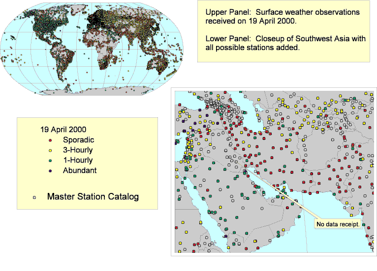
Figure 1. Maps used to monitor the Ingest Process.
Some maps used to monitor the ingest process are shown in Figure 1. The upper map shows locations that transmitted data on 19 April 2000. The lower panel is a close-up of Southwest Asia. The ingest data is color-coded by the amount of observations received. Analysts use this type of information to determine which locations to use in projects. The Master Station Catalog sites refer to locations that have weather stations. Note that Iraq has weather stations, but their data is not being transmitted, and is therefore unavailable for analysis.
AFCCC has several "Standard Products" that it produces. These types of products include standard climate summaries or data sets that are used by other applications. They also include narrative climatologies. Standard Products are continuously produced and upgraded. Once they are generated, they are archived so they will be available upon customer request. Figure 2 shows the availability of various Standard Products in Southwest Asia. This type of information is useful because there are over 10,000 climate summaries now available (various products at various locations worldwide).
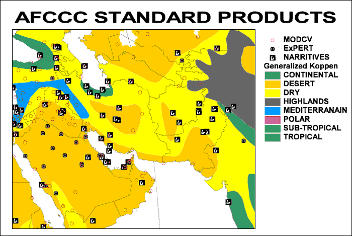
Figure 2. Availability of some of AFCCC's Standard Products.
In addition to Standard Products, AFCCC produces many "ad hoc" projects. These types of products are tailored to meet the customer's specific requirements. Therefore code has to be written (usually in SAS) to generate the statistics requested. However the first step involves selecting the stations to be used and insuring that the data is appropriate for the task at hand. Figure 3 shows an application that assists an analyst in acquiring data.

Figure3. Potential stations selected for analysis along with the corresponding feature table.
In this example, stations have been selected (light blue circles) for a region in Southwest Asia. Note the area does not have to be confined to a country or rectangular latitude - longitude box. The associated feature table shows some of the stations selected. The columns titled "Hh00", "Hh06", …, give the amount of observations at those times (UTC or Zulu). Note that most of the observations for Toraybeel are during the day (local time). Depending on the specific requirements, this station may not be used in the final analysis. The column titled "Alstg" indicates the total number of altimeter observations available. If there are no altimeter observations, there is a good chance that there is no pressure information available. Even if there is no explicit requirement for pressure statistics from the customer, it may be needed for other calculations. For example, many customers request absolute humidity data which requires pressure in its calculation. Other attributes the analyst may investigate include the elevation and the number of years for which data is available. So after selecting all the available stations within a customer defined region, the analyst may eliminate stations that are not appropriate for use. This application also has the ability to determine if the final station selections are currently loaded in Oracle tables. If not, a list of the missing stations can be generated and sent to the Database Branch. Also, a complete list of all the stations to be used can be generated for documentation or to actually be a part of the final software. This process used to take weeks for large request but now can be done more accurately in a matter of hours.
One of AFCCC's most popular products is the Operational Climatic Data Summary (OCDS). Each OCDS is a four page document containing summaries of temperature, precipitation, occurrence frequencies of significant weather (thunderstorms, snow, …), as well as joint probabilities of various ceiling and visibility categories for a specific site. There are over 7,500 sites already completed. If placed one on top of the another, the stack would be 25 feet high! By themselves, OCDSs are very useful but it is difficult to use this type of information in mapping or analysis applications. So several years ago, AFCCC began the process of converting the information in the digital documents into Oracle tables. This allows the information to be used in many applications including GIS. Figure 4 is a worldwide map of Mean Maximum Temperatures for June based on 7,500 sites stored in Oracle tables.

Figure 4. Mean Maximum Temperatures for June based on climate information stored in Oracle.
These types of maps can be generated for any of the pieces of information (precip, thunderstorms, …) in the OCDS tables. This information can also be used as a first step in geostatistical applications. For example the point features from the tables can be interpolated to create continuous surfaces. Obviously, this type of application is best done on a regional basis.
This data can also be used with statistical models that use climate variables as input. The Tattleman Rain Rate Model (Tattleman, 1994) uses mean monthly temperature, mean temperature range, mean days with precipitation, and mean precipitation amount to estimate rain rate statistics. Rain rate statistics are important in the design and maintenance of satellite communication links, army trafficability studies, and various types of construction projects. Figure 5 is an example of output from the Tattleman model based on input from the OCDS database.

Figure 5. Rain rate statistics based on climatology information stored in Oracle tables.
The model outputs the amount of time a user specified rain rate is exceeded and the amount of time there is precipitation actually occurring during an average month. This information is not available from conventional weather observations.
So far all the examples presented have dealt with point features based on conventional weather observations typically taken at airports. Although very useful, this type of data has limitations. Using the point data to create surfaces may be inappropriate in regions with complex terrain. Some regions may have little or no observations in the first place (see Fig. 1). Even if there is data, there may be limitation because of reporting procedures or quality. An alternative to observed data is to use data generated from a deterministic model which uses the equations of motion and various parameterization schemes to predict weather elements at grid points (surfaces). Meteorologists use this type of model to produce daily weather forecasts. AFCCC has modified this procedure by running the model for 10 year simulation to produce climatologies at 10 km grid points for various regions in the world (Van Knowe et. al. 1999, Doggett et. Al. 1999, www.afccc.af.mil ). This process is known as the Advanced Climate Modeling and Environmental Simulations (ACMES) project. Figure 6 is an example of a snowfall frequency climatology for Korea in January.
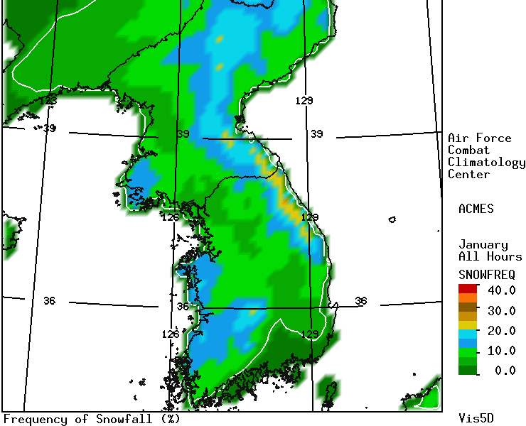
Figure 6. Percent frequency of snowfall in Korea during January.
The AFCCC web site has ACMES climatologies completed for Korea, the Persian Gulf, Europe, Mexico, and India/Pakistan. Because of the amount of different statistical parameters and weather variables, there are over 50,000 gif images available. This data can only be accessed by .mil and .gov sites. The data is also available in gridded format.
In order to ensure the quality of ACMES data and to help plan for improvements to the underlying model, AFCCC continuously verifies portions of the model output. Figures 7 and 8 are examples of how GIS is used in the verification process.
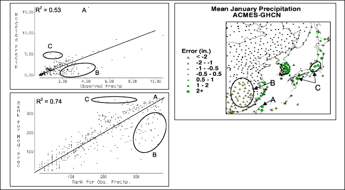
Figure 7. ACMES verification analysis for precipitation in Korea during January.
The analysis of January precipitation over Korea is shown in Figure 7. The panels on the left are scatter plots (Pearson Correlation Coefficient on top and Spearmen Correlation Coefficient on bottom) of the model error which is defined as the difference between the model climatology and the observed climatology. The panel on the right is a map of the model error at the weather stations used to verify the model. Problem areas are identified on the map and related to the points on the scatter plot (Point A, and the ellipses labeled B and C). Although the overall correlation between the model and observations is relatively high, there are some regions that could use improvement. This type of analysis helps the scientists working on model development to identify the physical processes that need to be improved within the model.
Figure 8 is a map displaying snowfall information over the Balkans. Again the error is defined as the difference between the model and the observed data, negative values indicate the model is under predicting the maximum December snow depth.
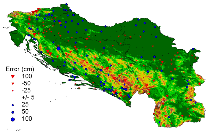
Figure 8. ACMES verification for maximum snow depth during December.
AFCCC also uses GIS to create attribute information for various data sets. Typically this is done using "spatial joins" between a polygon theme whose primary attribute is added to a point theme. Figure 9 give some examples of some polygon themes that might be used for this type of process.
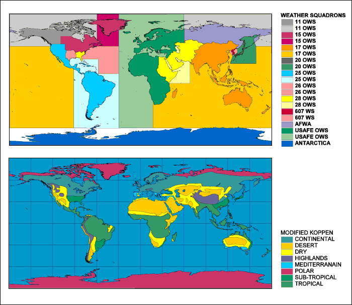
Figure 9. Polygon themes whose attributes are useful in metadata applications.
The top portion of Figure 9 shows the geographical regions associated with each Operational Weather Squadron (OWS). Air Force has divided the world into OWS regions in order to organize it's support and make it more efficient. This coverage is used in a spatial join with the metadata for AFCC's Standard Products. This allows a customer to enter the AFCCC web site and request the availability of a particular product within a given OWS region. This is a powerful for something like OCDS that has over 7,500 worldwide locations available. The lower portion shows a modified version of the Koppen Climate regions. This information is also being added to the metadata for Standard Products. This allows for powerful searches to be done instantly. For example, a customer could ask for all the OCDS's within the 25th OWS area of responsibility that are in a desert region and are above 150 meters of elevation. The OCDS's that meet those search criteria are returned immediately and are ready for download.
AFCCC often acquires other climate data sets from other sources to support customer requirements. Figure 10 shows two examples of worldwide data sets obtained from external sources. Data from the Global Gridded Upper Air Statistics (GGUAS) are visualized in the top panel. The lower panel is a visualization based on the Surface Marine Gridded Climatology (SMGC). These data sets can be used alone or combined with other data sets. The information starts out as point features arranged in a grid, but can be easily transformed into a surface for further visualization or GIS modeling applications.

Figure 10. GGUAS wind speeds in meters per second (top) and SMGS surface wind speeds in knots (bottom).
Another example of data obtained from another source is shown in Figure 11. This tornado data was obtained from NOAA's Storm Prediction Center. The data starts out as beginning and ending latitudes/longitudes of each tornado segment along with attribute data for each segment. The data must be processed to convert these quasi-point features into lines and build topology. Maps can be generated and symbolized as a function of any of the attribute fields. The map below shows tornado tracts as a function of F-Scale, which is a measure of tornado severity. This data is also useful for estimating the probability of a tornado at a specific location. Tornadoes are extremely rare events at any given point (even in Oklahoma-Texas), so are not likely to be recorded in conventional weather observations. By having a spatial distribution of tornadoes, however, probabilities and occurrences of tornadoes within a given radius around a location can be calculated.
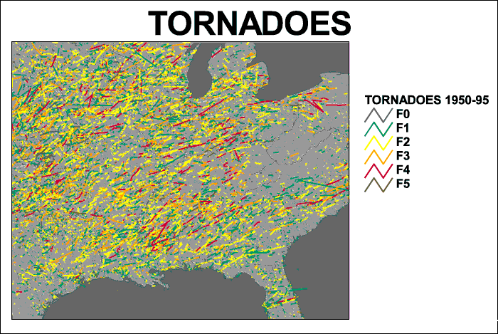
Figure 11. Tornado tracts color-coded by F-Scale (see text for details).
FUTURE PLANS
This paper has shown examples of how AFCCC uses GIS to visualize, manage, and analyze spatial data used in climatological applications supporting DoD customers. Future plans include moving much of the Standard Products into an Oracle database similar to OCDS. These product databases will serve as the foundation for many other applications (including GIS). We plan to investigate Spatial Database Engine as a way to enhance the availability of spatial information. Finally we want to implement GIS on our web site.
ACKNOLEDGEMENTS
Mr Ray Kiess developed the OCDS - Oracle Arc View application. Capt Matthew Doggett produced the ACMES verification applications. Many thanks to SSgt Kurt Reilly who helped get the graphics into a useable size and format for this paper.
REFERENCES
Doggett, M. K., M. Squires, and R. Kiess, 1999: An Evaluation of the Quality of Local Climate Statistics Generated from the Output of a 3-D Mesoscale Atmospheric Model, 11th Conf. on Applied Climatology, Dallas, TX, Amer. Meteor. Soc., 344-349.
Tattleman, P, 1994: A Climatological model for 1-min Precipitation Rates, Journal of Applied Meteorology, vol 34, pp1020-1027.
Van Knowe, G. E. , J. W. Zack, S. Young, M. D. Bousquet, P..E. Price, C. E. Graves, K. Poage, 1999: An evaluation of the sensitivity of local climate statistics generated from the output of a 3-d mesoscale atmospheric model to model configuration, data assimilation, resolution and subgrid parameterization schemes. Preprints, 11th Conference on Applied Climatology, Dallas, TX, Amer. Meteor. Soc.
AUTHOR INFORMATION
MICHAEL F. SQUIRES
Chief, Development Team One
Air Force Combat Climatology Center (828) 271-4235 x1070
151 Patton Ave., Rm. 120 DSN 673-9010