Twentieth Annual Esri International User Conference,
San Diego, California, U.S.A., June 26-30, 2000, paper 515
THE CHERNOBYL SARCOPHAGUS PROJECT
OF THE GERMAN-FRENCH INITIATIVE
ABSTRACT
At the Vienna Chernobyl Conference in April 1996 Germany and France declared to support the international co-operation in view of a solution of the Chernobyl related issues.
In 1998 the multinational Sarcophagus Project was launched in the frame of this initiative.
The aim of the project is collection, analysis, selection and verification of all safety relevant data concerning building constructions, systems and equipment, radiological situation, nuclear fuel, radioactive waste and environmental impact in a comprehensive data base.
ArcView GIS, spatial analyst and 3D analyst serve as a navigation system to retrieve the information from the data base using different cross sections of the Sarcophagus.
1. INTRODUCTION
After the declaration of Germany and France at the Vienna Chernobyl Conference in April 1996 to support the international co-operation of institutions of the Ukraine, Belarus and Russia in view of a solution of the Chernobyl related issues, three project were identified, i.e. the safety state of the Chernobyl Sarcophagus, the radioecological consequences due to the radioactive contaminated areas and the health consequences of the liquidators and the population in Ukraine, Belarus and Russia after the Chernobyl accident. The projects are funded by the governments and by the electricity utilities of Germany and France, respectively.
In this paper the Sarcophagus project will be presented.
Fourteen years after the accident of unit 4 of the Chernobyl NPP the Sarcophagus still remains one of the most dangerous nuclear facilities in the world. The ruin of the destroyed unit 4 and its surrounding Sarcophagus together are termed object Shelter.
The Sarcophagus was erected in a relatively short time period of several months on the basements of old structures of unknown stability of the former unit 4. Inside the Shelter remained about 96 % of the irradiated nuclear fuel inventory of the reactor of unit 4 before the accident, i.e. 180 t of Uranium of total radioactivity 7 x 10¹⁷ Bq. The radioactive releases to the industrial site of 500 m radius around the Chernobyl NPP during the first ten days after the accident were estimated to amount 0,5 - 1,0 % of the fuel inventory.
The spent fuel inside the Shelter and the radioactive contamination at the industrial site have an essential impact on all human activities concerned with investigation work, maintenance and stabilisation measures which are presently under progress e.g. in the framework of the Shelter Implementation Plan because of the radiation exposure.
For planning of any actions towards a stabilisation of the unstable building constructions of the Shelter and of measures to retain the radioactive materials inside the Sarcophagus a unified and comprehensive data base of all safety relevant technical data describing the present safety state of the Shelter is required.
Hence, the main aim of the Shelter project is the collection, analysis and selection as well as verification of all existing safety relevant data of the Shelter and the creation of an appropriate data base.
The data base will be useful for different applications, e.g. for performing stabilisation measures in the framework of the Shelter Implementation Plan (SIP) or for the corresponding licensing procedure of the national authority of Ukraine.
2. PROJECT ORGANISATION
The project management is carried out by GRS and IPSN on behalf of the German and French governments and utilities, respectively. The local project co-ordination in Ukraine is carried out by the Chornobyl Centre which will also be the beneficiary of the work. The work is being performed by local contractors. The progress of work is frequently estimated and ruled by the project review group from the above mentioned organisations together with the contractors.
During a preparation phase after the declaration of the initiative in 1996 the main tasks of the project were identified and the terms of references including detailed technical specifications of the work were elaborated. These main tasks are Building Constructions, Systems and Equipment, Radiological Situation, Fuel Containing Materials and Radioactive Waste and Environmental Impact.
In May 1998 the sub-projects with the local contractors were launched.
The project duration is three years, the total budget amounts to 4 Million Deutsche Mark.
The technical organisation of the project is the following. For each technical task in a first step the main sources of information, i.e. technical documents, publications etc., were identified and described in a bibliography. In the next steps the technical quantities of interest are extracted from theses documents and input into a data base. The input of data is performed by the contractors using especially designed interfaces, which address the kind and the total amount of data for the given task. The development of interfaces, the structure and the configuration of the data base as well as the data integration is subject to a separate contract.
Besides internal quality control of the technical data, performed by each of the contractors, additionally an independent expert team of Atomaudit (AA), Kiev, Ukraine, is involved in external quality control of the work. The configuration of the data base and data integration is also subject to independent control by a GRS supervisor.
3. CONTENTS OF WORK
3.1 Building Constructions
The contents of this work is the description of the building constructions before and after the accident. To the parameters considered in this task belong the geometrical dimensions of the rooms, of the walls and of special objects, their properties, e.g. quality of concrete and other building materials, load bearing capacity, order of destruction of walls and other construction elements, newly filled concrete and accessibility of rooms, etc. These data serve as a basis for new projects to reinforce the Sarcophagus.
This work is being carried out by the State Research Institute of Building Constructions (NDIBC), Kiev, Ukraine.
3.2 Systems and Equipment
This work contains the description of all systems and equipment installed in the Shelter before and after the accident, i.e. electricity supply systems, water supply and drains, ventilation system, measuring and monitoring systems, etc.
This work is being carried out by the NDIBC in co-operation with the Chernobyl Nuclear Power Plant, Object "Shelter" (CNPPOS), Chernobyl, Ukraine.
3.3 Radiological Situation
The scope of this work is the description of the radiological situation inside the Shelter, i.e. the dose rates of the radiation fields and the radioactive contamination in the rooms of the Shelter. In order to estimate the radiation exposure in advance when planning work to be carried out by the personnel these data are of special interest.
This work is being carried out by the Russian Research Center “Kurchatov Institute” (RRCKI), Moscow, Russia, in co-operation with the CNPPOS.
3.4 Fuel Containing Materials and Radioactive Waste
The contents of this work is the description of the remaining fuel inside the Shelter, i.e. fragments of spent fuel elements, molten fuel lava, radioactive dust and Uranium and Plutonium solutes in the water in the lower rooms, the nuclide compositions, the physical and chemical properties etc. These data are very important because of their direct relevance for risk estimates. On the basis of these data for example, GRS investigated together with RRCKI the potential radiological consequences of a roof collapse of the Sarcophagus followed by a release of radioactive dust
/1/, /2/ as well as the criticality behaviour of the fuel lava under the destroyed reactor vessel /3/ .
This work is being carried out by the RRCKI.
3.5 Environmental Impact
This work deals with the description of the influence of the accident to the Shelter site, i.e. the radiation situation above the ground, the contamination and the behaviour of the groundwater, the airborne effluents from the Sarcophagus and the radioactive air contamination at the Shelter site. These data are also of special interest e.g. for planning preparation work near the Shelter for stabilisation measures etc.
This work is being carried out by the Interdisciplinary Scientific and Technical Centre "Shelter" (ISTC), Chernobyl City, Ukraine.
3.6 Data Base Configuration and Data Integration
The scope of this work is the development of the data base structure, including the bibliography and the contributions of the different technical tasks, described above, as well as the development of a proper technique to retrieve the required information by key words as well as by the help of the optical navigation system ArcView GIS.
4. DATA BASE CONFIGURATION
4.1 Structure and Features of the Data Base
The data are organised and structured according to the main topics of contents described above in a data base under Microsoft Access. The technical topics are subdivided into objects, e.g. rooms, construction elements, systems, equipment elements, measuring devices, fuel assemblies and fuel debris, pieces of fuel lave, etc., which are generally connected with the corresponding 3D co-ordinates (axis, row and height level). The 3D co-ordinates of the Shelter are prolonged towards the industrial site allowing the description of the environmental impact to the Shelter site in a uniform co-ordinate system.
The states of the objects are described by a text abstract and by the technical parameters with regard to the terms of references of the contracts. Auxiliary data, e.g. graphs, construction drawings, photos, original and animation videos, are also linked with the technical data to facilitate a better understanding.
The main technical quantities contained in the data base are always linked with the corresponding main sources of information described in the bibliography. A hint to the responsible contractor validating the technical data is also always given.
All data are presented bilingual in English and in Russian using a switch button.
4.2 Retrieval and Navigation Systems
All information available in the data base can generally be retrieved by an optical navigation system based on ArcView GIS 3.2.
For each height level of the Shelter a 2D cross section containing the main objects, e.g. walls, doors, rooms, stairs, main constructions elements, newly filled concrete, fuel containing materials, main systems and equipment, etc. was elaborated.
Analogously, for the Shelter site a 2D cross sections containing data about the elevation levels of the territory, the radiation fields at height levels from 1 m up to 70 m above ground as well as about the groundwater table and the radioactive contamination of the groundwater was designed.
From the ArcView platform via the information button a direct entry to the access data base is released and all primary technical and auxiliary data can be found. Using the animation button additional information from original and animation video films can be started.
4.3 Presentation of 3D Images
Selected images can be viewed by means of the 3D analyst. This is of special interest for the whole Shelter and the industrial site as well as for different objects belonging to more than one height level. For such kind of objects also a direct access from the 3D images to the data base was realised.
4.4 Applications
For practical purposes and different applications a processing of the primary data contained in the data base is of interest. The scope of the Sarcophagus project of the German-French Initiative does in general not include processing of primary data and production of secondary data for special practical applications by means of models etc. However, some simple applications based on a straight algorithm, i. e. prognosis of dose rate in the future based on the radioactive decay of Cs 137 etc., have been foreseen. Other applications available are facilitated by the spatial analyst.
One example is the calculation of the dose uptake of personnel due to radiation exposure when walking over contaminated areas at the Shelter site or in rooms inside the Sarcophagus in high radiation fields. Indicating a walk route and a constant moving velocity of the personnel, the spatial analyst calculates the accumulated dose along the pathway.
5. RESULTS
5.1 Bibliography
The bibliography compartment of the data base contains different data, describing the main sources of information, from which the technical data are extracted. It contains also links to the compartments, where the technical data are stored as well as the key words for retrieval. Fig. 1 shows a plot of the interface for input of the main sources of information
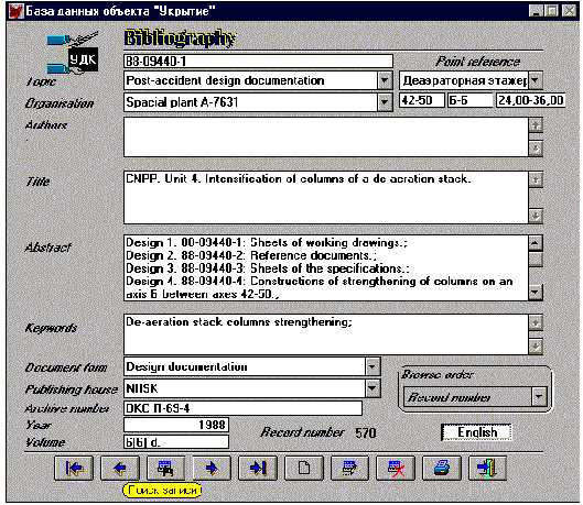
Figure 1: Interface for main sources of information (Bibliography)
5.2 Object Shelter and Industrial Site
Using the 3D analyst the whole object Shelter can be shown under different angles.
Fig. 2 shows the ruin of the former reactor building of unit 4 of the Chernobyl NPP and the newly built Sarcophagus in front from the west, adjacent to the south are the de-aeration building and the machinery (turbine) hall. The chimney is common to the Shelter and the unit 3.
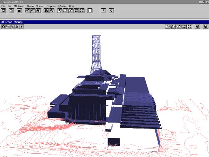
Figure 2: General view of the object Shelter and the industrial site from the west
Fig. 3 presents a view from the north-west with height profile of the territory and the groundwater table.
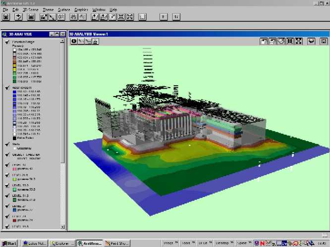
Figure 3: Shelter site from the north-west with height profile of the territory and the groundwater table
5.3 Environmental Impact of the Sarcophagus to the Shelter Site
Fig. 4 shows a 2D plot of the total elevation level of the Shelter site above Baltic Sea level in m. Furthermore the positions of observations wells for investigation of the groundwater and the aspiration units for air contamination sampling are depicted.
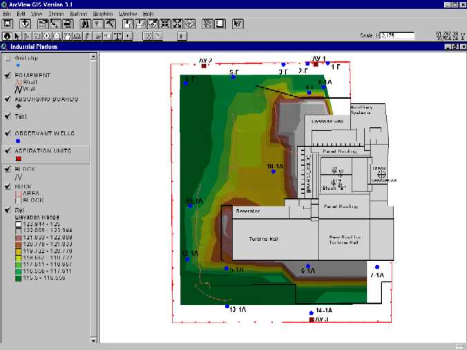
Figure 4: 2D plot of the total elevation level of the Shelter site above Baltic Sea level in m
In Fig. 5 the radiation situation is plotted at 1 m height above ground as the dose rate in mR/h.
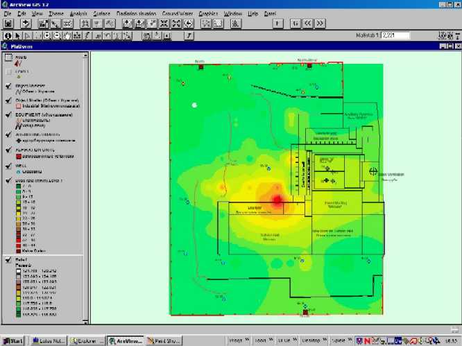
Figure 5: Dose rate at 1 m height above ground in mR/h
Fig. 6 shows the groundwater table at the Shelter site and the positions of the observation wells.
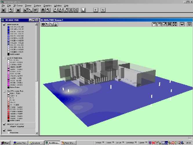
Figure 6: Groundwater table at the Shelter site and the positions of the observation wells
In Figs. 7 and 8 the groundwater contamination with the radionuclides Sr 90 and Cs 137, respectively, is drawn.
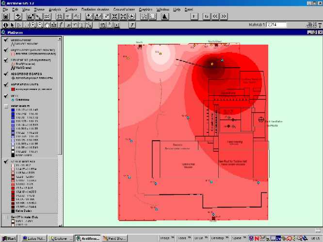
Figure 7: Groundwater concentration of the radionuclide Sr 90 in Bq/l
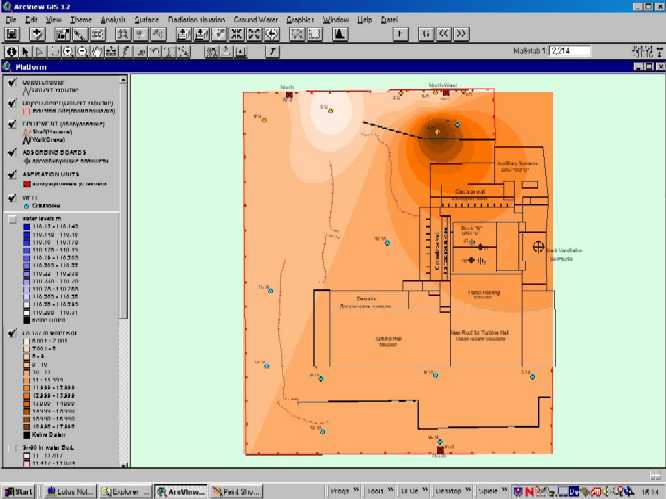
Figure 8: Groundwater concentration of the radionuclide Cs 137 in Bq/l
5.4 Cross Sections of the Shelter
Figs. 9 and 10 are examples for a general view of 2D plots of the Shelter cross sections. In the cross sections of the different height levels of the former reactor building the main objects described in the data base are indicated. For example, the red spots in Fig. 9 at level 6.00 m are fuel containing lava assemblies.
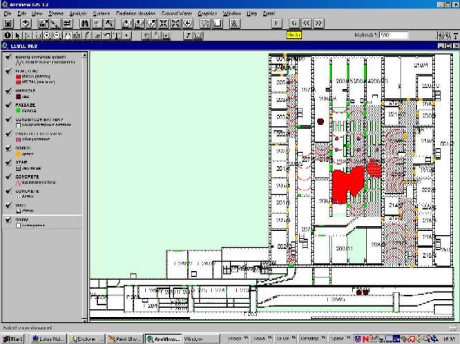
Figure 9: Cross section of the Shelter at height level 6.00 m
Fig. 10 shows the cross section of the Shelter at level 9.00 m. The red cross indicates the former basement of the reactor vessel.
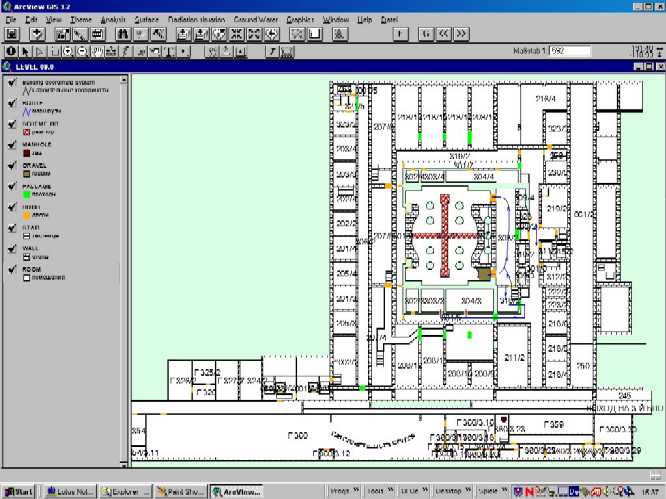
Figure 10: Cross section of the Shelter at height level 9.00 m
5.5 Building Constructions
In Fig. 11 a 3D image of height level 0.00 m is plotted. It shows the newly filled concrete during and after the accident to extinguish the fire and to stop the release of radioactive aerosols to the environment.
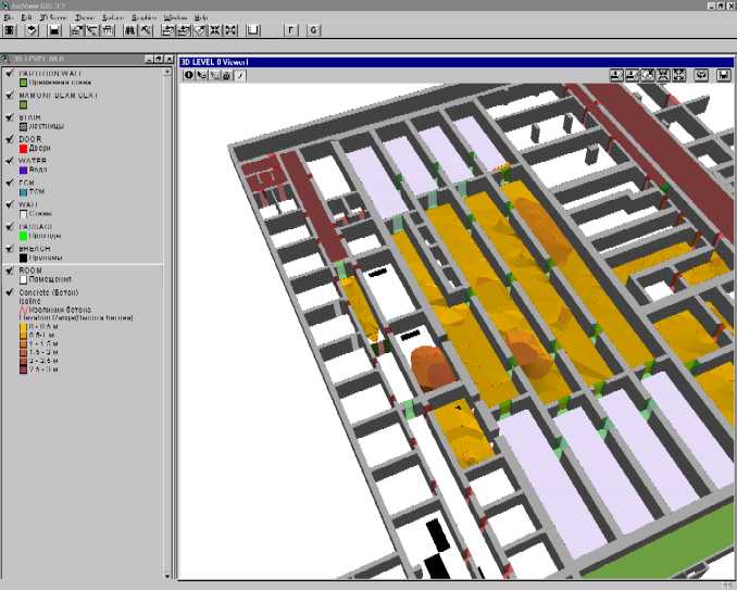
Figure 11: 3D image of the Shelter at height level 0.00 m with newly filled concrete
Fig. 12 shows the grid beam "Mammon" bearing the roof of the Sarcophagus over the former de-aeration building.
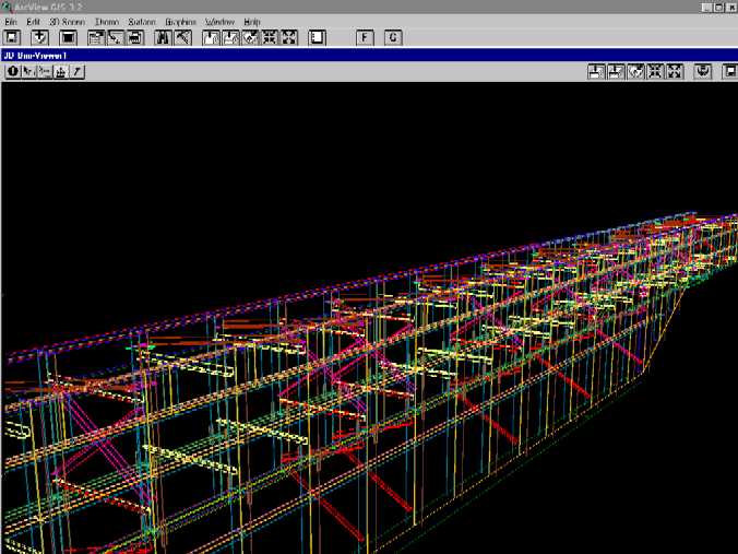
Figure 12: 3D image of the grid beam "Mammon" bearing the Sarcophagus roof
5.6 Radiation Situation
In this section an example of the radiation fields at height level 0.00 m and an application with the spatial analyst are demonstrated.
Fig. 13 shows a 3D plot of the dose rate in the central room at height level 0.00 m.
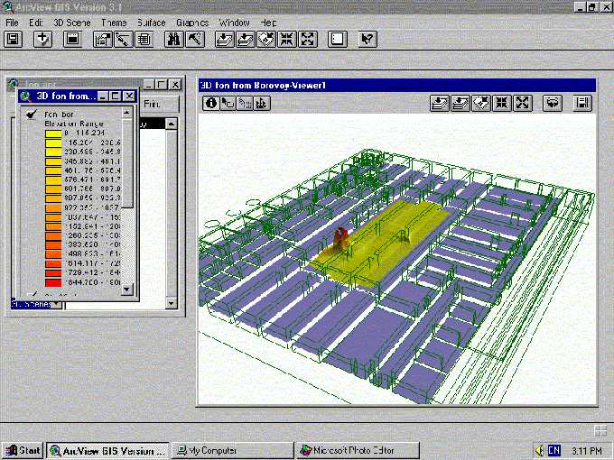
Figure 13: 3D plot of the dose rate in the central room at height level 0.00 m in mR/h.
In the following Fig. 14 a 2D plot of the dose rate in the central room at height level 0.00 m is shown along with the route of walk of personnel. It can be seen that following the rectangular route the worker passes first a small contamination spot and then a bigger contamination spot of fuel lava and fuel debris assemblies.
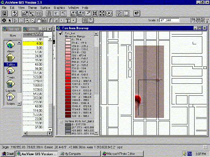
Figure 14: Following the rectangular route of walk the worker passes first a small contamination spot and then a
bigger contamination spot of fuel lava and fuel debris assemblies
In Fig. 15 a graph of dose rate versus distance of walk of personnel along the route corresponding to Fig. 14 is shown. The spatial analyst integrates the dose rate and calculates the accumulated dose of radiation exposure.
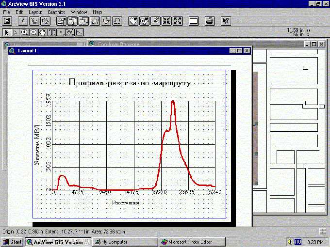
Figure 15: Dose rate versus distance of walk of personnel along the rectangular route corresponding to Fig. 14 and
dose calculation using the spatial analyst
5.7 Fuel Containing Materials
Fig. 16 provides information about the retrieval of technical data from the data base concerning the fuel containing materials. Using the ArcView GIS scheme the places of fuel containing materials are indicated by red points. Selecting a certain point the results from data retrieval are indicated. In this case the nuclide composition of a sample taken from the selected fuel assembly is presented.
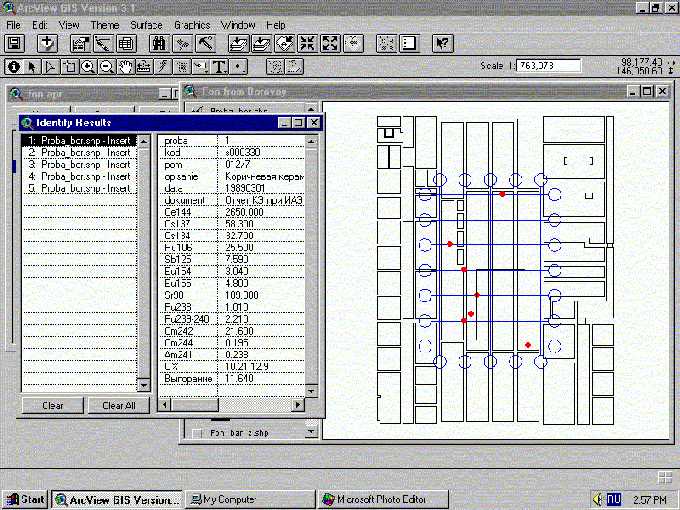
Figure 16: Retrieval of technical data by means of the ArcView GIS navigator concerning
the nuclide composition of
fuel containing materials
Another example to retrieve auxiliary data from the data base concerning the fuel containing materials is shown in the next Fig. 17. Using the ArcView GIS navigator and pushing the animation button original and animation video films illustrating the selected fuel assembly are available.
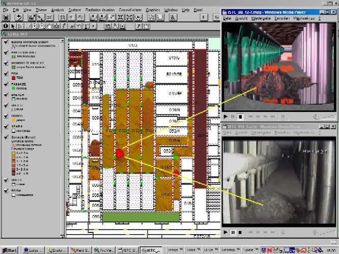
Figure 17: Retrieval of auxiliary data, i.e. original and animation video films illustrating the selected lava fuel assembly
The upper picture right shows an animation video of the fuel lava assembly, indicated at the 2D cross
section by the red spot, the lower picture right shows an original video of the same fuel lava assembly.
ACKNOWLEDGEMENTS
The Sarcophagus Project is a multinational project with contributions from Germany, France, Russia and Ukraine. Referring to the contracts almost 50 experts are contributing to the Chernobyl Sarcophagus data base.
The authors deeply appreciate the collaboration with all organisations involved, especially with the managers and main experts of the contractors, namely:
Y. I. Nemchinov and A. K. Khavkin (NDBIC)
V. I. Kupny and V. N. Senatorov (CNPPOS)
A. A. Borovoy and S. A. Gavrilov (RRCKI)
S. A. Bogatov and V. N. Shcherbin (ISTC)
A. B. Mazur and D. S. Datsko (ECOMM)
G. A. Kopchinsky and N. A. Steinberg (AA)
R. Roloff (GRS)
REFERENCES
/1/
G. Pretzsch
"Radiological Consequences of the Hypothetical Accident
"Roof Breakdown" of the Chernobyl Sarcophagus",
Proc. IAEA/EC/WHO Int. Conf. "One Decade after Chernobyl",
Vienna, Austria, April 8-12, 1996,
IAEA-CN-63/415, IAEA-TECDOC-964, pp.591-597, Sept. 1997
/2/
G. Pretzsch, F. Lange, S. Bogatov and A. A. Borovoy
"Radioactive Dust inside the Chernobyl Sarcophagus",
Proc. of Spectrum’98, International Conference on Decommissioning
and Decontamination and on Nuclear and Hazardous Waste Management,
Sept 13-18, 1998, Denver, Colorado, U.S.A., Vol. 1, pp. 221-226
/3/
B. Gmal, G. Pretzsch, E. Moser and U. Quade
"Investigation of the Criticality Behaviour of the Fuel Containing
Lava Masses inside the Chernobyl Shelter",
Proc. ICNC ’99, Sixth International Conference on Nuclear Criticality Safety,
Sept 20-24, 1999, Versailles, France
AUTHOR INFORMATION
Dr. Gunter G. Pretzsch
Gesellschaft für Anlagen- und Reaktorsicherheit (GRS) mbH,
Kurfürstendamm 200
10719 Berlin
Germany
TEL: 0049 30 885 89 145
FAX: 0049 30 885 89 111
EMAIL: prg@grs.de
Mrs. Elisabeth Salat
Insitut de Protection et de Sûreté Nucléaire (IPSN),
B.P.6 - 92265 Fontenay-Aux-Roses
Cedex
France
TEL: 0033 1 4654 7208
FAX: 0033 1 4654 7088
EMAIL: elisabeth.salat@ipsn.fr
Mr. Alexander N. Seleznev
Chornobyl Centre for Nuclear Safety, Radioactive Waste and Radioecology,
17 Kharkov Chaussee
02090 Kiev
Ukraine
TEL: 0038 044 558 7471
FAX: 0038 044 559 9806
EMAIL: sel@riskaudit.kiev.ua
Mr. Eugene S. Seredynin
JV "ECOMM" Co.
18/7 Kutuzov str.
252133 Kiev
Ukraine
TEL: 0038 044 294 4218
FAX: 0038 044 294 8202
EMAIL: es@ecomm.kiev.ua