ABSTRACT
The GIS of Landscape Units of Italy has been realized in order to map the landscapes of Italy at a regional scale (1:250,000), with the aim of defining land settings that exhibit a homogeneity at such scale. This has been the basis to develop a new method for evaluating environmental quality and territorial vulnerability.
Landscape units have been recognised following an approach based on a synthetic and integrated study of the structural elements of the landscape in their composition and pattern. Interpretation of satellite imagery and aerial photographs played a primary role in the realisation of the map, integrated with field surveys and ancillary data.
In order to quantify the values on environmental quality and territorial vulnerability of each landscape unit, some indicators of environmental conditions have been chosen. These parameters, entered into the GIS or derived from it, have been combined in an experimental mathematical model.
The geo-database has been realised in an Arc/Info-ArcView integrated environment.
INTRODUCTION
The "Carta della Natura" Project (Italian Law 394/91) aims to evaluate the conditions of the natural environment in Italy, identifying the natural values and the environmental vulnerability of the country.
In order to carry out land management functions, this tool must be up-datable, multiscalar and it has to contain a wide range of information concerning the environment, i.e. the physical, biotic and anthropic aspects and their interrelations. From this point of view, a Geographic Information System is needed.
In the realization of the "Carta della Natura" Project, we started from the identification and classification of the landscape regional setting (scale 1:250,000).
The landscapes were identified following an approach based on an integrated study and synthesis of the composition and pattern of the elements that constitute the physiognomy of each type of landscape, using remote sensing.
The outcome of such analyses is the production of a map of landscape units, that represent the features subject to the application of ecological models measuring both quality and vulnerability.
In order to classify and map the landscapes was chosen a synthetic approach. This integrated approach could be attained in practice by studying the elements which form the landscape structure (e.g. physiographic components and land cover), since these are the visible expression of the endogenous and exogenous phenomena, as well as of the human activity, generating the landscape. This study consisted of the identification of such elements, of their spatial relationships and of the patterns in which they are organised. Because each landscape has a clearly identifiable pattern, it was possible to distinguish any particular landscape from surrounding ones.
Among the elements forming the landscape, only those that can be directly observed at the regional scale were considered in our landscape classification. These are the physiognomic-structural features of the land, and treating them as a set allows the different landscape settings to be distinguished as structurally homogeneous portions of the Earthĺs surface. At the regional scale the main elements considered were the morphological, lithological, vegetational and land-use features, analysed according to their composition and pattern. Taking as its point of departure the assumption that precise emergent properties can be recognised for each scale of observation, at the hierarchical level corresponding to a regional scale, it is the physiography which best approximates the results of a landscape study performed following a synthetic approach.
On the basis of the conceptual approach outlined above, a number of landscape types were identified. These are typical associations of land features recognisable at a regional scale. The parameters used to distinguish and describe the different landscape types were in the main related to the morphologic (elevation, relief energy, drainage pattern, physiographic components), geologic and landcover settings (see also SIGEA, 1994-1995), as shown in Fig. 1.
|
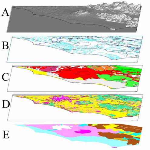
Figure 1: Example of the synthetic approach followed in the recognition of landscape types and units in the area surrounding Rome. The main territorial informations are shown as layers in the figure: A) shaded relief from the DEM (250m cell); B) Hidrography; C) Lithology; D) Land Cover (about 10 classes); E) Landscape Units. |
Moreover, in order to define some types, it was indispensable to observe their relationships with the surrounding landscape shapes. Such observations can be clarified by referring to the example of the plain areas. At a regional scale, plains are often very similar from a litho-morphologic and landcover point of view, but in reality they may correspond to different landscapes. If they occupy a valley-floor between ridges ("valley floor plain" type) they will have a different configuration compared to those plain areas not limited by the sides of a river valley ("wide open plain" type) or to those developed along the sea coast ("coastal plain" type).
As regards the land cover observed at regional scale, a fairly good association exists between the land cover pattern and the units identified using physiographic criteria, besides sites subject to high human impact such as urban areas.
The climate deserves a consideration as such, since it shapes the landscape pattern by modifying both the land cover and the heights through exogenous processes. In this respect, analogous types situated in different climatic contexts exhibit diverse landscape patterns.
At regional scale, the climatic influence can be detected at a very general hierarchical level; the types were therefore classified also according to their belonging to a bioclimatic region, either euro-siberian or mediterranean.
Identifying and delimiting the landscape type that characterises one defined geographical area, we obtain a "landscape unit", and this represents the fundamental unit for the "Carta della Natura" system at the 1:250,000 scale. Every landscape unit is marked by one landscape type and a precise geographical location, which gives its name to the unit; units are, therefore, unique. Their identification and mapping was achieved by identifying the local and unique features of specific geographically defined portions of the landscape.
At the 1:250,000 scale, the "landscape units" presented here can be related to the "land systems" class in the "land classifications" applied by some international institutes and organizations (FAO, 1974; CSIRO: Christian & Stewart, 1953; 1968; ITC: Van Zuidam & Van Zuidam Concelado, 1978 and Zonneveld, 1979; CFS: Lacate, 1969; Giordano, 1989; Tricart & Kilian, 1985).
The "Landscape Unit Map of Italy" was realised principally by use of remote sensing, and mainly through interpretation of aerial photographs. This method is the most appropriate for landscape analysis at a regional scale: it permits a synoptic study of the land which is consistent with a synthetic approach and the immediate reading of the elements forming landscape structure. The "Volo Italia 1988-89" aerial photographs (Ferretti, 1989), at the nominal scale of 1:75,000, were used, because they cover, homogeneously, the whole national territory at an appropriate scale for our study.
Interpretation of the aerial photographs allowed the identification of the landscape units, and was accompanied by their mapping on IGMI (Istituto Geografico Militare Italiano) topographic maps at the scale 1:250,000. Details of each unit were also noted on worksheets that contain the following: a general description of the landscape structure, both geographic and related to the landscape type attributed to the unit; the altitude arrangement and the relief energy class; the observed physiographic components; the lithology; the drainage pattern; the land-cover.
Moreover, the results were integrated with field surveys (suitably performed), and compared to the national and international scientific literature (Carta geologica dĺItalia, 1:100,000; Carta geologica dĺItalia, 1:500,000; Sestini, 1963; Boccaletti, 1982; Accordi et al., 1988; Forman & Godron, 1986, and references inside; Bonardi et al., 1988; Pedrotti, 1991; Reichenbach et al., 1992; Pignatti, 1994, and references inside). Previous studies by public administrations were also taken into account (e. g.: Regione Marche, 1991; Regione Toscana, 1994; Regione Emilia Romagna, 1987). In particular, careful reference was made to the published thematic maps.
The map and the related tables, converted to digital format, form a data base that is part of a Geographical Information System (GIS); in fact, GISĺs are considered to be the most logical choice for structuring an ecological data base (Risser & Treworgy, 1985; Haines-Young et al., 1993, and references inside).
The integration process of the landscape unit map into the GIS is quite standard. We only preferred an authomatic vectorisation process (Laserscan VTRAK) rather than manually digitising the handwork of the interpreters. The tolerances of the output were chosen according to the 1:250,000 scale.
The description of types and units is managed in a twofold manner: A Ĺshortĺ description is stored in the Polygon Attribute Table linked to the map, to be visualised by the default tools in the specially designed ArcView project. The more detailed units and types descriptions are instead stored in text files and visualised by a personalised Graphical User Interfaces within the same ArcView project (Fig. 2), where are also included the links to the 1:50,000 maps of habitats that forms the second main layer of the "Carta della Natura" Project.
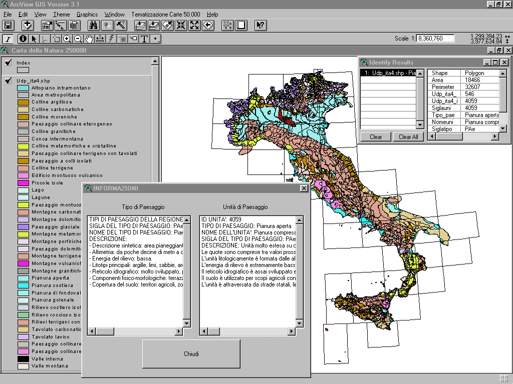
Figure 2: Screen capture showing the elementary configuration of the ArcView project to visualise and describe the map of the landscape units and types. The IGMI 1:250,000 topographic sheets borders are also shown (color quality of the image is of course lower than the original).
As requested by the Law and according to the official raster topography used as a reference, the landscape unit map, as well as the other layers included in the GIS, was organised as an ArcInfo Library, using the borders of each IGMI topographic sheet as the library index.
Among the layers included in the library we can quote the different administrative units coverages, the hydrography, highways and nationally relevant roads, railroads, Land Cover map (according to EU CORINE legend), that come into play in the process of quality and vulnerability assessment (Haines-Young et al., 1993). Also raster data as the IGMI topographic reference and the Digital Elevation Model (DEM) produced by the national Geological Survey in a 250m cell Grid, are included in the GIS.
The landscape units identified in the entire Italian territory represent the set of features for environmental quality and territorial vulnerability assessment, i.e. the fulfillment of the "Carta della Natura" Project main goal.
The attribution of environmental quality to a landscape unit is based on a number of ecological and institutional criteria. Different hierarchical levels were considered to derive the ecological criteria, namely the Ĺunitĺ level, the Ĺhabitatĺ level and the Ĺhabitat composition of the unitĺ level. Concerning institutional criteria, the presence of natural parks, reserves or protected areas was taken into account.
The evaluation of the territorial vulnerability aims at estimating the sensitivity of a habitat to perturbations or to conditions that assure their spatial and temporal persistence.
Two additional parameters were also considered: the contextual sensitivity that evaluates the landscape structure where a certain habitat is found, and the intrinsic sensitivity that examines the characters of the habitat per se.
From what has been described so far, we can sum up the principal steps of the work undertaken (Fig. 3).
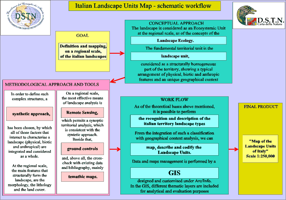
Figure 3: Schematic workflow followed for the realisation of the "Carta della Natura" Project at the 1:250,000 scale.
1) Identification and description of the landscape types for the Italian territory; from this classification, applied to specific and unique geographic zones, and completed with the description of more local features, we obtain:
2) the mapping, description and codification of the landscape units; these units were mapped on IGMI topographic maps at the 1:250,000 scale.
3) The creation of a data base organised in a GIS designed ad hoc required for management of all the data and maps.
4) Environmental quality and vulnerability models were implemented in the GIS system and applied to the landscape units. The models can be easily modified in case of changes to the model flow or if new parameters need to be included.
Accordi, G., Carbone, F., Civitelli, G., Corda, L., De Rita, D., Esu, D., Funiciello, R., Kotsakis, T., Mariotti, G. & Sposato, A. 1988. 'Carta delle litofacies del Lazio-Abruzzo ed aree limitrofe. Note illustrative', Quaderni de "La ricerca scientifica", 114 (5), p. 223.
Arc/Info 1997. Version 7.1.1. Copyright 1982-1997. Environmental Systems Research Institute, Inc.
Boccaletti, M. (Ed.) 1982. 'Carta strutturale dellĺAppennino settentrionale. Scala 1:250,000', CNR., P. F. Geodinamica, 429.
Bonardi, G., DĺArgenio, B. & Perrone, V. (Eds) 1988. 'Carta geologica dellĺAppennino meridionale. Scala 1:250,000', Mem. Soc. Geol. It., 41.
Christian, C. S. & Stewart, G. A. 1953. 'General report on survey of Catherine-Darwin region, 1946', Land Research Series, 1, Canberra: CSIRO.
Christian, C. S. & Stewart, G. A. 1968. 'Methodology of Integrated Surveys', Proceedings of the Conference on Aerial Surveys and Integrated Studies, UNESCO, Toulouse, 233-280.
CEE 1993. CORINE Land Cover, Guida tecnica, CORINE Programme.
FAO 1974. 'Approaches to land classification', FAO Soils Bulletin, 22, p. 120.
Ferretti (Ed.) 1989. Volo Italia, aerial photographs of Italy, nominal scale 1:75,000.
Forman, R. T. T. & Godron, M. 1986. Landscape Ecology, John Wiley & Sons, p. 619.
Giordano, A. 1989. 'Il telerilevamento nella valutazione delle risorse naturali'. Riv. Agr. Subtrop. e Trop., 83 (1). Istituto Agronomico per lĺOltremare, Firenze.
Haines-Young, R., Green, D. R. & Cousins, S. H. (Eds) 1993. Landscape Ecology and GIS. Taylor & Francis, p. 288.
Istituto Geografico Militare Italiano (IGMI). Carta ĹIl Mondo (JOG) 1501ĺ, serie 250/G, scala 1:250,000.
Lacate, D. S. 1969. 'Guidelines for Bio-physical Land Classification', Canadian Forest Service Publication, 1204, p. 61.
May, R. M. 1989. Ecological Concepts, Blackwell Es., p. 363.
Meinig, D. W. 1979. 'The interpretation of Ordinary Landscapes', Geographical Essays, Oxford, Oxford University Press.
Naveh, Z. & Lieberman, A. S. 1984. Landscape Ecology Theory and Applications. Springer-Verlag.
OĺNeill, R. V. 1989. ĹPerspectives in hierarchy and scaleĺ. In: Roughgarden J., May R. M. & Levin S. A. Eds: Perspectives in Ecological Theory. Princeton University Press.
O'Neill, R. V., De Angelis, D. L., Waide, J. B. & Allen, T. F. H. 1986. A Hierarchical Concept of Ecosystems, Princeton Univ. press, p. 254.
Pedrotti, F. (Ed.) 1991. 'Carta della vegetazione reale dĺItalia. Scala 1:1,000,000', In: Ministero dellĺAmbiente, Relazione sullo stato dellĺambiente.
Pignatti, S. 1994. Ecologia del paesaggio, UTET, Torino, p. 225.
Prigogine, I. & Stengers, I. 1984. Order out of chaos: man's new dialogue with Nature, Bantam Ed., New York.
Regione Emilia Romagna 1987. Piano Territoriale Paesistico regionale, Ass. Edil. Urban. Regione Emilia Romagna, Bologna.
Regione Marche 1991. Lĺambiente fisico delle Marche, Ass. Urbanistica-Ambiente, Ancona.
Regione Toscana 1994. I sistemi di paesaggio della Toscana, p. 157.
Reichenbach, P., Acevedo, W., Mark, R. K. & Pike, R. J. 1992. 'A new landform map of Italy in computer shaded relief', Bollettino di Geodesia e Scienze Affini, 52, 21-44.
Risser, P. G. & Treworgy, C. G. 1985. ĹOverview of ecological research data managementĺ. In: Research data management in the Ecological Sciences. Columbia, S. C.: University of South Carolina Press.
Servizio Geologico Nazionale. Carta Geologica dĺItalia. Scala 1:100,000.
Servizio Geologico Nazionale. Carta geologica dĺItalia. Scala 1:500,000.
Sestini, A. 1963. Il paesaggio, Collana: "Conosci lĺItalia", T. C. I., Milano, 7, p. 232.
SIGEA ("Società Italiana Geologia e Ambiente" Ed.) 1994-1995. 'I paesaggi geologici italiani', Materiali Verde Ambiente, n. 2, 3, 4, 5, 6 (1994), 1, 2, 3 (1995).
Tricart, J. & Kilian, J. 1985. Lĺecogeografia e la pianificazione dellĺambiente naturale, Franco Angeli Ed., Milano, p. 310.
Van Zuidam, R. & Van Zuidam Concelado, F. I. 1978. Terrain Analysis and classification using aerial photographs, ITC Textbook, 8 (6), p. 348.
Vink A. P. A. 1983. Landscape Ecology and Land Use. Longman, New York, p.171.
Zonneveld, S. J. 1979. Land Evaluation and Landscape Science, ITC Textbook of Photointerpretation, 7, p. 134.
Thanks are due to Vittorio Amadio for leading the group in the first years and continuous interaction, Daniela Di Bucci and Rita Salvucci as co-authors of the Italian Landscape Units map, Angelo Lisi, Francesca Procaccini and Francesco Piacentini for helping in GIS editing, Franco Petracca and Giorgio Scarsella for PC and Unix system managing.
This work is dedicated to Beatrice Crescenzi.
N. LUGERI*
GIS manager in the "Carta della Natura" working group (e-mail nicola.lugeri@dstn.it)
M. AMADEI*, R. BAGNAIA*, L. LAURETI*, F.R. LUGERI*, S. NISIO*
Geologists in the "Carta della Natura" working group
M. DRAGAN**, M. FERNETTI***
GIS - Remote Sensing experts
D. LAVIERI**, G. ORIOLO**
Naturalists
*Presidency of the Council of Ministers - Italian Department for National Technical
Services - Via Curtatone 3, 00185, Roma, Italy
tel. +39.06.4444.2291 (.2866) fax +39.06.4444.2192
** Department of Biology, University of Trieste - V. Giorgieri 10, 34127 Trieste,
Italy
tel. +39.040.676.3883 fax +39.040.568855
*** GEOLAB, University of Trieste - Via Valerio 12, 34127 Trieste, Italy
tel. +39.040.676.3304 fax +39.040.676.3316