Beyond Administering a Map: Using GIS Technologies to Aid
in the Development of Municipal Zoning Codes.
Paul Freedman
Abstract
GIS systems are often viewed as only a tool for improving the administrative functions of municipal zoning. While GIS systems are especially capable at aiding in the notification, tracking, and mapping of zoning relationships, the analytical tools can offer much more. By introducing these tools early in the zoning code development process, not only can better public participation be achieved, but improved regulatory schemes can be developed. This paper reviews how the City of Columbus, Ohio, has combined GIS technologies with the development of zoning code language to better regulate cellular transmission towers and urban commercial corridors. The paper concludes with five critical points that were learned through the case studies.
Introduction and Background
The city of Columbus has been quite active in the development of a city wide geographic information system (GIS) for the last several years. The focus has been on the automation of routine business practices and the production of highly accurate thematic maps. While this has resulted in an increase in the accuracy and efficiency in administering the zoning code, the GIS system is still primarily relegated to a more traditional role of a support tool rather that allowing for full integration in the entire zoning process. Originally viewed as primarily a "turn-key" system, it has evolved into a full-scale GIS system that not only supports the casual user, but offers the technical researcher the opportunity to manipulate data and develop unique, individual coverages and data layers.
The traditional role of GIS as a post-zoning administrative tool has been well documented. The recent movement has been to use the analytical tools that a GIS system introduces to not only assist in the administration of the zoning code, but in the development of the code as well. Over the last few years, the number of employees who use mapping software in the city of Columbus has steadily climbed. As a result, several departments, including the Department of Trade and Development, have begun to expand their use of GIS technology beyond the daily administration of zoning and building codes into the area of policy development.
Even though the analysis is admittedly less complex than in other areas, the incorporation of GIS based mapping directly in the code development process is still rather unique. The two case studies presented highlight the combination of GIS system mapping with the complex and often contentious process of developing zoning codes. The first case study reviews the mapping process used in development of an "Urban Commercial Overlay" to assist in the preservation of older, urban commercial corridors. The second case study looks at the mapping process used to assist in the development of new code language for dealing with the placement of cellular telecommunication towers.
While the city of Columbus has been moving forward in the development of the citywide GIS system, most of the base data was generated by Columbus' host county. The various departments of Franklin County have been using GIS to store, develop, and analyze development related data. The primary agency has been the Franklin County Auditor's Office, which produces a quarterly compact disk that contains planametric data and property appraisal information. The co-operative effort between Franklin County and the city of Columbus has been instrumental in moving the GIS project forward.
Case Study #1
Development of an Urban Commercial Corridor Overlay
As commercial development and redevelopment occurs along urban thoroughfares in older Columbus neighborhoods, the current development standards contained in the Columbus Zoning Code do not easily adapt to allow these newly constructed businesses to fit within the already established land use pattern. The requirement for large setbacks and the need to accommodate off-street parking has resulted in sporadic development that does not easily fit into the original pedestrian oriented architecture of these older urban corridors. An ordinance that allowed areas to be designated as "Urban Commercial Corridors" and have alternative standards apply was developed and reviewed. While the drafting of the actual new code language was important, the significant and most controversial step was to decide what areas along these older, urban corridors were to be included in the overlay thus subjected to the alternative standards.
Traditional planning techniques are time consuming and expensive. A survey team is sent out to map and photograph the areas to be included in the overlay. Then the field team has to classify and map on film or other media the commercial land uses upon returning to the office. This redundancy further increases the lead time and costs required for the project. The result is a base map of the commercial frontages, but does not generate any information as to the density of the surrounding residential land uses. This residential density information would prove important in helping to decide exactly what sections of Columbus' many urban corridors were best suited to be protected by the proposed overlay.
These alternative standards addressed such issues as parking, setback, commercial facades and glazing area requirements, commercial entrances and exits, and sidewalk plazas. The ordinance itself states its objectives as:
In an effort to reduce the time and cost involved in completing the research prior to the actual code development process, the GIS system was incorporated into the actual code development process for two important mapping needs. This was in addition to the more traditional role of owner notification and zoning administration that the GIS would be involved with later in the overlay process. The GIS maps would not only help in defining the boundaries for the special zoning areas, but would also help the city defend the new zoning codes in any potential legal action. The base map that was developed was based on the parcel data as mapped by the county Auditor's Office. The land use classifications used in the assessment and evaluation process were included in this data.
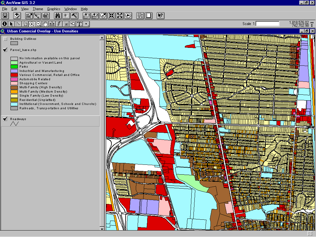
The first use of the GIS system was to determine the density of residential neighborhoods abutting urban commercial corridors proposed for inclusion in the overlay. This helped not only to improve the marketability of these older commercial areas and the concept of an "urban commercial overlay", but also helped to offset any negative development pressure from being included in a potentially restrictive zoning overlay. This relatively simple analysis, illustrated in Figure 1, shows the commercial corridors with the neighboring residential neighborhoods in various shades or brown, with the darker browns keyed to the highest densities.
Figure 1
Though once again the analysis is not complex, the presentation of the data in a format that was unique for the code development process was critical. At the time of the initial public meeting it became clear the without the aid of even a simple thematic map as shown in Figure 1, the process would never start to focus on specific criteria or even legally defensible language for the new zoning code. Several neighborhood groups were not even sure that an "Urban Commercial Overlay" would help as much as hurt any potential redevelopment. The use of the residential density map in the process marked a sharp departure from the old code development process. This map assisted in the identification of areas where the overlay could be applied and that a clear and concise argument could be made that the residential densities would be high enough to overcome any negative economic pressure from being included in an overlay area. Though the first map did help answer some questions and calm some concerns of the neighborhood groups, it quickly became apparent after several more public meetings that further review of certain key areas was needed.
The second analysis and map was based on the age of certain structures located along specific urban commercial corridors. The Planning Office of the Department of Trade and Development helped to collect the detailed information needed to map the parcels by the age of their respective buildings, and this helped to better define the areas that would eventually be included as an overlay area. The final map, shown in Figure 2, indicated the location of older commercial storefronts and certainly helped in the code development process.
Figure 2
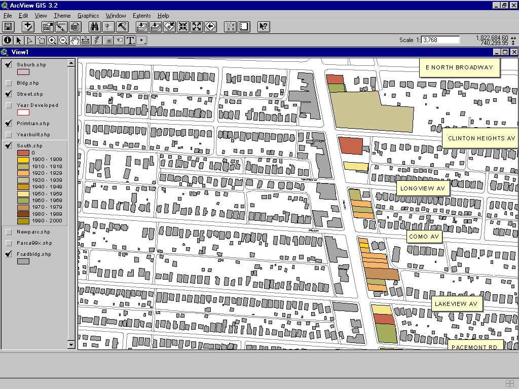
Once again the maps helped to answer questions that members of the public had about the overlay areas. Both maps helped to serve as focal points in meetings with public boards and organizations, and also aided in visualizing the affected areas. On several occasions during the process the maps helped to highlight areas where the code needed further development. At one point, a large format (three feet by eight feet) map based on the map in Figure 1 was printed and used to highlight the level of detail that was being evaluated. Once again, the map did not include any new analysis, but served to show the value the code development team placed on neighborhood input.
In addition to serving as a tool to help focus discussions and efforts, the maps also became part of the "legislative history" behind the development of the new zoning code changes. As such, the maps became critical if the code changes were ever legally challenged. The GIS technology helped to produce a code change that was based on explicit criteria developed from measurable phenomena and that was also reasonable and enforceable.
It was in this way that the code development team earned the trust of both the neighborhood groups that were skeptical of the process and the code change itself, and also earned the trust of both the City Attorney and City Council. While in the end controversy was still present and not all parties got all that they had requested, the focus was not on the code language and the areas to be included in the overlay, but rather on the timing of the implementation. It would be naive to think that relatively simple analysis and maps alone facilitated the development of the code, they did simplify the process and helped to develop code that was demonstrably effective, persuasive and reasonable.
Case Study #2
Zoning Requirements for Cellular Telecommunication Towers
The Telecommunication Act of 1996 (the "Telecom Act") provided the legislative groundwork to allow for the expansion of wireless telecommunication services and provided for the establishment of national wireless telecommunication networks. Though the act is quite broad in scope, it is Section 704 of the act that provides the guidelines within which local jurisdictions are allowed to regulate such transmission facilities. While the act clearly states that local authority is preserved, it also makes it clear that these facilities can not be prohibited.
|
Section 704 of the Telecommunications Act of 1996 (the "1996 Act") governs federal, state and local government oversight of siting of "personal wireless service" facilities. The 1996 Act establishes a comprehensive framework for the exercise of jurisdiction by state and local zoning authorities over the construction, modification and placement of facilities such as towers for cellular, personal communications service (PCS), and specialized mobile radio (SMR) transmitters:
zoning authority may be preempted by the FCC.
(FCC Fact Sheet #1, April 23, 1996) |
Due to growth in the wireless telecommunication industry, encouraged by the "Telecom Act" and due in part to the development of new wireless technology, the city of Columbus experienced an exponential increase in the number of applications for zoning variances for the installations of the required transceiving facilities because the local zoning code made no provision for such facilities.
This burdensome requirement was not only consuming city resources, but also potentially violating Section 704 of the "Telecom Act." The code needed to provide better guidelines as to where such transceiving facilities should go by right without the need for a public hearing, as well as the performance standards (i.e. landscaping, buffering, security fencing) for the installation itself. It is interesting to note that the code that was eventually developed and agreed upon resulted in performance standards that were often higher than those required by the Board of Zoning Adjustments (BZA) at their public hearing.

The backbone of the wireless system are the transceiving facilities or transmission sites. These sites and the use of monopole antenna supports, as illustrated at right, created a policy dilemma. While the act did preserve local zoning authority, the restrictions on that authority were extensive. The "Telecom Act" required local municipalities to allow for the growth of the technology, but also placed limits on how their siting colud be regulatedas desired by local neighborhoods.
As mentioned above, increase in consumer demand for wireless services and the increase in affordability of wireless services resulted in the need for additional transceiving facilities. This corresponded with the push by wireless service providers to increase market penetration (Business First; Columbus, Ohio, November 8, 1996, page 77) and as unused sites that could easily accommodate transcieiving facilities became more scarce, the stage was being set for confrontation. The code changes and additions would have to allow wireless service providers to expand and increase their networks' capacity, as required by the "Telecom Act," while encouraging thoughtful location and placement of these new facilities.
The obstacle was developing the zoning criteria that would allow for both the expansion of wireless services as well as for the need to develop sites that could best accommodate such antenna structures. The city of Columbus' early GIS mapping resources, coupled with older paper based maps, proved indispensable in assisting with the development of the code and in demonstrating the code's impact in later reviews of the codes effectiveness.
These code changes and additions provide for the location of monopole antennas in certain zoning districts with specific standards, including encouragement for the collocation of antennas, while also allowing some flexibility for the placement of antennas up to 20 feet in height on existing legal structures to limit the number of future monopole antenna sites that would be needed. Alternatives to traditional siting plans (see Figure 3 on the right) were also developed.
It quickly became apparent that the primary obstacle in the development of new zoning code language was deciding what setback would be required for the placement of free standing monopole antenna supports and associated support buildings. While a review of other zoning codes showed that most municipalities chose a specific setback, it was felt that a setback that did not take into account the height of the proposed structure would simply encourage the construction of the tallest monopole allowed. A setback based on the height of the proposed structure would encourage the utilization of the shortest monopole needed.
The final step in the code development portion was to actually develop a setback figure. A review of Columbus' zoning pattern showed that some of the best locations for siting these antennas location were on large parcels zoned for manufacturing and commercial uses. The problem was that these same zoning classifications were often used not only for large industrial tracts and regional shopping malls but also for small commercial and industrial parcels that lined older urban thoroughfares. The final setback figure would have to allow for these monopoles in the large parcels of appropriately zoned land while protecting residential districts located adjacent to smaller commercial and industrial land uses.
The GIS system enabled us to create a map that showed, with a series of concentric circles, at what setback the smaller zoned manufacturing and commercial parcels would no longer be able to accommodate a free-standing monopole of average height (between 80 and 100 feet). The process used to develop that map is indicated below. The process assumed that the best possible location, regardless of the availability of a particular site, was at the parcel center. That point would show the setback needed under the most ideal conditions to allow for the tallest monopole.
The first step was to create a base map (shown in Figure 4) that showed all parcel boundaries, streets, and building footprints. Please note that at that point in time, the city's zoning map was not completely digitized, so a proxy land use classification from the Franklin County Auditor's GIS system was converted and used. While these were not perfect, they proved to be satisfactory for the process after comparing them to similar sections of the printed zoning maps.
Figure 4
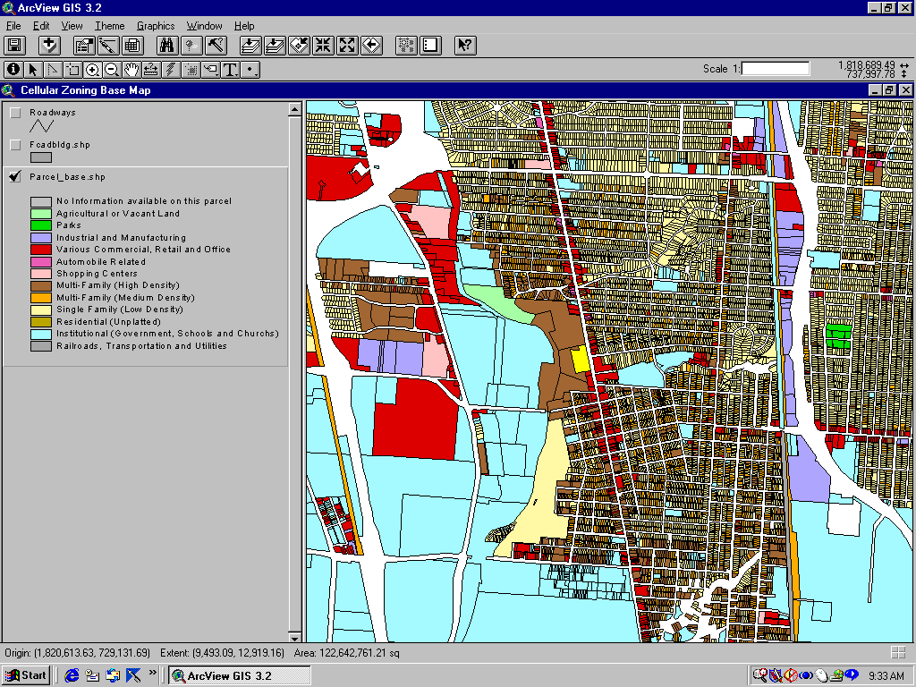
Figure 4 shows a view of a small subsection of the county base map used in the development of the new zoning code sections. This base map provided a good starting point and helped to reassure all those involved in the process of developing the new code that the all of the details were taken into consideration. The code development process was contentious, but far less contentious than that experienced during the development of the "urban commercial overlay." Once again, the maps not only helped to reassure all participants that the process was considering all concerns and issues, but also demonstrated to members of City Council the effort that was involved to assure that the code that was chosen in the end would balance all concerns.
The next step was to identify parcels that were zoned for commercial or manufacturing uses and then calculate and map the center points of these parcels, as shown in Figure 5.
Figure 5
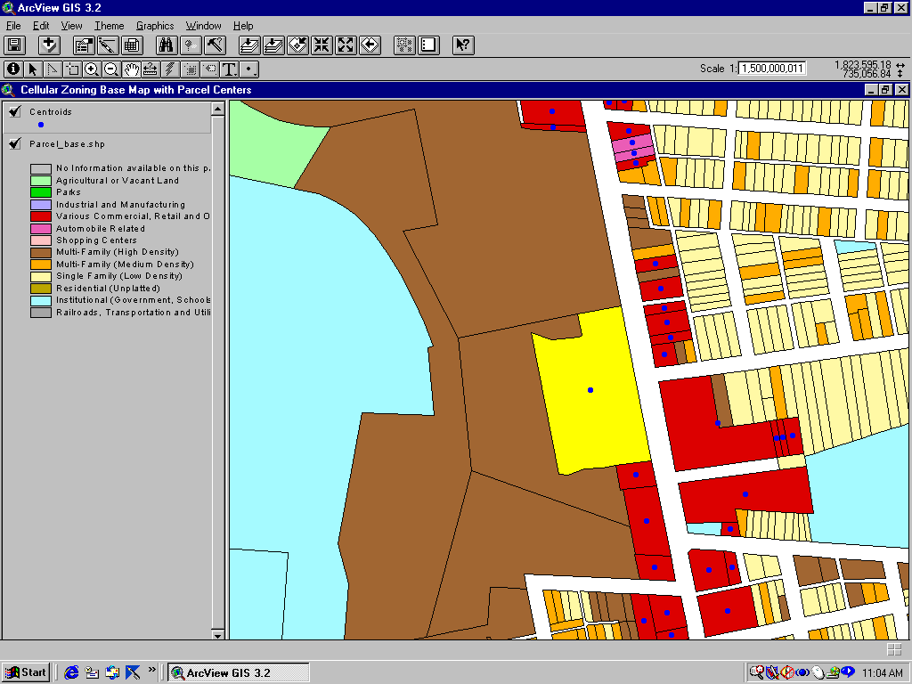
Once the selected parcels' centroids were mapped, they were then buffered (shown in Figure 6) with concentric fifty-foot rings to depict the various distances to the surrounding residential parcels in order to assist in the determination of the setback requirements.
Figure 6
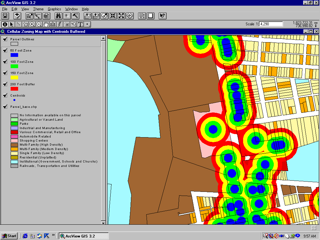
Once the map was developed, it became apparent that a "double the height" (200 percent) setback would allow for the siting of free-standing monopoles on and near large parcels zoned for commercial and manufacturing uses. This pleased both the neighborhood representatives as well as the wireless service providers and helped to avoid the creation of a complex enforcement mechanism. The code development process was now complete and the only act left was official passage.
The visual aspect of the display can not be underestimated as this helped to convince not only skeptical neighborhood groups that the resulting code protected the interests of all involved, but also was helpful in other ways. The maps helped to convince key council members that the resulting changes would actually work and minimize the numbers of freestanding monopole towers required while not violating federal law. The GIS technology helped to not only shape the regulatory scheme, but also helped convince others that the scheme would work.
Lessons Learned
Too often GIS technology is not viewed as a tool for the actual development of zoning code and is simply relegated to being used a part of a process serving system. As our cities continue to grow and urban patterns change, the need to develop more highly specialized zoning codes will continue. GIS needs to be an integral part of the development of these need codes and standards. The codes developed with the assistance of GIS technology are less cumbersome to write, administer and comply with. They are also more legally sound and thus more easily defended in any possible court action.
The GIS technology, beyond allowing the relatively simple analysis and maps highlighted earlier, help to focus the code development process and resulted in codes and ordinances that were more effective at actually solving the problems that necessitated the code to start with. The mapping technology assisted in developing codes that were:
It became clear that GIS technology certainly has a place in the code development process and its use certainly reduces the potential for problems and conflicts. Yet, even armed with maps and the latest technology, the political process can not be forgotten or completely removed. The process of code development and its intricate dance with property rights makes almost any change to municipal codes a potentially contentious undertaking. Even apparently simple changes can hold hidden pitfalls. The GIS system may not remove all or any of these known problems, but it can certainly minimize them.
Acknowledgements
The data used in these projects has been converted for use with Esri software and has been processed using various software packages. This paper represents the effort of many staff members and hours of work both on the project as presented as well as on supporting and implementing the GIS systems and needed infrastructure. Please note that while the projects were originally completed in earlier versions of Arc/View, they have all been updated to be compatible with Arc/View 3.2.
Paul Freedman
Research Analyst Specialist - Information Systems
City of Columbus - Department of Trade and Development
City of Columbus, Ohio
Phone - (614) 645-7247
Fax - (614) 645-7855
E-Mail - pmfreedman@cmhmetro.net