P5441.gif (6462 bytes)

p5442.gif (2477 bytes)

National Geographic Information System
SUNIL
National Unified Information System     

p5443.gif (2160 bytes)

By: Mónica Ruano and Miriam Aguilera.

P5444.jpg (1687 bytes)

P5445.jpg (3732 bytes)P5446.jpg (3910 bytes)P5447.jpg (3826 bytes)

P5448.jpg (4162 bytes)P5449.jpg (3924 bytes)

ABSTRACT:

The main purpose of the National Geographic Institute of Guatemala (IGN) is to provide reliable geographic and cartographic information to assist in the country’s development. For this reason, the IGN develops and coordinates the country’s National GIS.

During the past year, the IGN coordinated with SEGEPLAN and other government organizations a cartographic project of major importance: the SISTEMA UNIFICADO DE INFORMACION NACIONAL –SUNIL- (National Unified Information System). The project aims to digitalize the thirteen sheets of the 1:250,000 scale topographic map of Guatemala, which will make up the first complete National Digital Database of the total Guatemalan territory. This database originates from a standarized data structure with appropriate geometric and topological control. This project marks the beginning of the IGN’s modernization by using top-quality digital technologies to develop the National GIS, which will be of great importance in the decision-making process of planned country-wide projects.

By means of the SUNIL project, the IGN will show how any government or private organization can update their production line of cartographic information using new technology (hardware and software), to create a cartographic base that will help plan and decide upon important subjects for the development of the country.

P5444.jpg (1708 bytes)

DESCRIPTION

During recent years, Guatemala has experienced an increased demand for reliable geographic and cartographic information covering social, economic and natural features, among others, to assist in the development of the country, especially in what concerns public investments.

For such reason, a Commission to coordinate the Information System for Geographic Modernization (CCMSIG) was created in 1996. This commission was a Presidential initiative to strengthen, standardize and modernize the country’s geographic information. Conforming the commission were a Presidential delegate, a representative from the National Geographic Institute, one from the Secretariat of Planning and Programming for the Presidency (SEGEPLAN), consultants from the United States Agency for International Development (USAID), consultants from the World Bank, representatives from the Registry of Property, the National Institute of Statistics (INE), and the Ministry of Defense.

At the time, the objectives of the commission were to promote institutional integration, to decide upon standards for geographical information and to provide guidelines to develop the national cadastre, in order to enable all the participating organizations to work with the same standards, concepts and technical specifications.

In 1998, the first results from international cooperation (Canada, Sweden, France and Japan) became evident through the implementation of the several projects that intend to modernize the National System of Geographical Information.

The next step, in May of 1999, was the creation of the Interinstitutional Unit. The Unit began to produce the National Geographic Database, UNISNIG, whose duties would involve coordination, promotion and organization of the National Geographic Information System. During 1999, the National Geographic Institute (IGN), worked coordinated with the Secretariat of Planning and Programming for the Presidency (SEGEPLAN), and other government agencies, a cartographic project of most importance: The SISTEMA UNIFICADO DE INFORMACION NACIONAL "SUNIL" (National Unified Information System).

The SUNIL project, a cartographic and information experience, is the very first at a national level of organization which enables access to completely digitized geographic information in record time.

The Guatemalan government and its agencies, as well as all international organizations, will be able to access through Intranet. SUNIL is a unique reference for all projects, for the planning and monitoring of several programs and is a valuable aid in the decision-making process for public investments.

What is the SUNIL Project?

Before the only geographic information available in Guatemala was in paper format. The country’s development has made evident the need of precise, exact and timely geographic information; therefore, a geographical database was built. In order to rapidly implement the geographical information, a pilot project was created: SUNIL. The main part of the of on-screen digitation of the thirteen 1:250,000 scale topographic maps of the Guatemalan territory, in order to produce the basic geographical information in digital format.

p54410.jpg (16705 bytes)

PROJECT REQUIREMENTS:

p54411.gif (12610 bytes)

TECHNICAL PROCESS:

p54412.jpg (24811 bytes)

The information sources used for the project were developed during the 60's, 70's and 90's using classic cartography.

Sources: thirteen sheets, twelve of them  1° 30’ x 1°, and one made up of territory fraction maps that are near an international border. Every complete map covers approximately 18,000 square kilometers. The relief is indicated by contour lines of 100 meters and supplementary ones of 50 meters. All this information was processed using photomecanic methods, to be translated into a 7 thousandth of inch positive film, because of the material stability.

P54413.gif (29463 bytes)


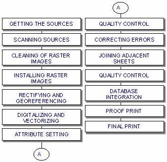
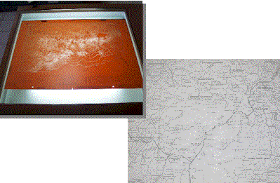
Scanning of the sources: upon getting the sources ready, the next step is scanning. Scanned sources were: roads, drainage, contour lines, and administrative division layers. As an additional reference information, the geographic coordinates of every topographic sheet were also included.

Cleaning of the raster images: scanning produces raster format images. The scanning process causes spots in the images. The spots are therefore erased using appropriate software.

Installing raster images in the computer:   first, the images are installed in the workstation, taking as reference the four vertices in each image that contain the geographic coordinates. The software generates an automatic process which converts these coordinates into UTM (Universal Transverse Mercator), used for rectifying and georeferencing the image.

Digitalizing and Vectorizing: we used ARC INFO 7.1.2 for both processes. Some programming in AML was required to automate frequently used commands and tasks.

Attributes Setting: attributes were set depending on the nature of the layers. E.g., the roads network (rca) uses a classification (Central American, national or state), a condition (all-weather, hard surface, all-weather loose surface, dry loose surface, track) and the number of classification (CA-1,10).

Quality Control: after digitation and vectorization of each layer are completed, a partial print is produced to confront the digitized information against the sources of information. If any errors are found, they are corrected.

Joining adjacent sheets: next step after verifying the information of the 13 sheets, is to join adjacent sheets in order to obtain layers for the total Guatemalan territory.

Quality Control:  the work would not be finished if the quality of the final information is not verified. First, the information per sheet was viewed in ARC VIEW 3.1, then it was printed and verified again against the information sources.

Database Integration:   this is the last step of the technical process. All the digitalized information is integrated. The geographic information is ready to be used for developing applications or for a final print.

P5444.jpg (1687 bytes)

WWW LINKS 

National Geographic Institute of Guatemala (IGN) http://www.ign.gob.gt

Secretariat of Planning and Programming for the Presidency (SEGEPLAN) http://www.segeplan.gob.gt

National Institute of Statistics (INE) http://www.ine.gob.gt

Del Valle University   http://www.uvg.edu.gt

P5444.jpg (1687 bytes)

ACKNOWLEDGMENTS:

* Interinstitutional Unit
* United States Agency for International Development (US-AID)
* National Geographic Institute - France International (IGN-FI)

P5444.jpg (1687 bytes)

Authors Information

Mónica Ruano Montalván
Chief of the Informatic Division
National Geographic Institute of Guatemala
Ave. Las Américas, 5-76 zone 13, 01013,Guatemala, Central America
Tel. (502) 332-2611, Fax. (502) 331-3548

ign@ign.gob.gt
Miriam Aguilera Kontio
Director of the Informatic Division
Secretariat of Planning and Programming for the Presidency
9 calle 10-44 zone 1, 01001, Guatemala, Central America
Tel. (502) 232-6212  Fax. (502) 251-7258
maguilera@segeplan.gob.gt

 hola