
Reductive Dehalogenation of Chlorinated Ethenes
by Bryan R. Maurer
Cummings/Riter Consultants, Inc.
Reductive Dehalogenation of Chlorinated Ethenes |
Perhaps the most important and most understood of the biodegradation processes with respect to chlorinated aliphatic hydrocarbons is reductive dechlorination of highly chlorinated solvents, such as trichloroethene (TCE). The figure to the left illustrates the sequential reductive dechlorination of chlorinated ethenes. During this process, the chlorinated hydrocarbon is used by subsurface microorganisms as an electron acceptor, removing a chlorine atom and replacing it with a hydrogen atom. With the appropriate environmental conditions, this sequence may occur uninterrupted, ultimately resulting in non-toxic products. |
If natural attenuation processes can be shown to be capable of attaining specific remedial objectives within a reasonable time frame, then Monitored Natural Attenuation (MNA) may be selected as the preferred remedy for a site, alone or in combination with other more active remedies including source control and/or reduction. The U.S. Environmental Protection Agency (USEPA) has developed a protocol for the collection and analysis of appropriate data used to evaluate the potential occurrence of natural attenuation processes at sites with impacted groundwater. The data obtained can then be used to provide technical support during subsequent screening and evaluation of remedial options for those alternatives which include MNA as part of the remedy.
The primary objective of the natural attenuation evaluation protocol is to evaluate whether natural processes can attain remedial objectives within a reasonable time period as compared to other remedial alternatives. This requires the projection of future extents and concentrations of contaminants, based on historic variations and measured rates of attenuation. Because of the inherent uncertainty of such predictions, sufficient evidence must be provided to demonstrate that MNA will meet the site objectives.
USEPA has delineated the key steps involved when demonstrating the viability of MNA as a potentially feasible remedial option. These steps include:
This paper focuses on using geographic information system (GIS) software to perform the second step, the initial screening assessment.
After reviewing available site data and developing a conceptual site model, a preliminary assessment of the potential occurrence of natural attenuation must be made. USEPA has developed an initial screening process to evaluate whether the geochemical conditions are amenable to reductive dechlorination, the predominant attenuation mechanism for chlorinated solvents.
The first step of this initial screening process is to evaluate geochemical data from the contaminant source zone, within the dissolved contaminant plume, downgradient of the dissolved plume, and upgradient and lateral areas not impacted by the plume. The geochemical data is scored as shown in the table below, based on the concentration for each relevant parameter. For example, if the dissolved oxygen concentration at a given location is less than 0.5 milligrams per liter (mg/l), 3 points are awarded. This scoring method relies on the fact that the occurrence of biodegradation will cause predictable changes in groundwater chemistry (e.g., decreased dissolved oxygen concentrations). USEPA’s Technical Protocol describes the relevance of these parameters.
| Parameter | Conc. | Scoring Value | Parameter | Conc. | Scoring Value | |
| Oxygen | < 0.5 mg/l > 5 mg/l |
3 -3 |
Chloride | > 2x bckgrnd | 2 | |
| Nitrate | < 1 mg/l | 2 | Hydrogen | > 1 nM/l | 3 | |
| Iron II | > 1 mg/l | 3 | Vol. Fatty Acids | > 0.1 mg/l | 2 | |
| Sulfate | < 20 mg/l | 2 | BTEX | > 0.1 mg/l | 2 | |
| Sulfide | > 1 mg/l | 3 | Trichloroethene | daughter product | 2 | |
| Methane | > 0.5 mg/l | 3 | Dichloroethenes | daughter product | 2 | |
| Temperature | > 20 şC | 1 | Vinyl Chloride | daughter product | 2 | |
| pH | < 5 or > 9 | -2 | Dichloroethanes | daughter product | 2 | |
| TOC | > 20 mg/l | 2 | Chloroethane | daughter product | 2 | |
| Oxid./Reduct. Potential | < 50 mV < -100 mV |
1 2 |
Ethene/Ethane | > 0.01 mg/l > 0.1 mg/l |
2 3 |
|
| Carbon Dioxide | > 2x bckgrnd | 1 | Chloroform | daughter product | 2 | |
| Alkalinity | > 2x bckgrnd | 1 | Dichloromethane | daughter product | 2 |
The total score is added up at each location and interpreted as follows:
If a total score of 15 or more points is achieved at sampling points within or immediately downgradient of the source area, then it is likely that natural biodegradation is occurring. In this case, further characterization and modeling should be conducted to assess the potential performance of a MNA remedy. Otherwise, other attenuation processes (abiotic degradation, volatilization, or sorption) should be evaluated, or remedies other than MNA should be considered.
The typical approach for performing the initial screening described above is to enter the data into a spreadsheet and manually perform the scoring. This method provides a table of scores for each sampling point, which can then be manually presented on a site map.
GIS software, and in particular the ModelBuilder extension included in Esri’s ArcView® Spatial Analyst 2 provides an alternate method for performing this screening automatically. Using this extension, a model can be built to create interpolated grids of the sample data from each point, reclassify the grids based on the scoring values provided in the guidance, and then add the reclassified grids together to create a single map which graphically identifies portions of the site where natural attenuation is likely to be occurring. Once this model is built, portions can be modified and rerun, and the entire model can be reused to evaluate the occurrence of natural attenuation for other projects.
 Interpolation Type Selection |
In defining the model, the first step is to create interpolated grids of values based on the point data available for each of the required analytical parameters. Decisions to be made when using the point interpolation wizard include which interpolation method to use (inverse distance weighted [IDW] or spline, as shown to the left), interpolation parameters such as number of nearest neighbors, and optionally how to classify the legend for the grid. Note that the legend classification can be, but doesn’t have to be, consistent with the concentration ranges listed in the scoring table shown above. The result of this step is a continuous grid of actual and interpolated values (in this case, concentrations) throughout the study area for each parameter. |
| The second step in developing the model is to define a reclassification function for each of the interpolated concentration grids. For each parameter, a new integer value is assigned to a given range of concentrations based on the scoring values provided in the USEPA guidance. For example, grid locations with an interpolated dissolved oxygen concentration of less than 0.5 mg/l are assigned a value of 3, locations greater than 5.0 mg/l assigned a value of -3, and locations with a concentration between 0.5 and 5.0 are assigned a value of 0 (see the figure to the right). The result of this step is a continuous grid of reclassified point values for each parameter. |  Grid Reclassification |
 Arithmetic Overlay |
The final step in developing the model is to perform an arithmetic overlay, where each of the reclassified point value grids is spatially added together, as shown in the figure to the left. The legend for the resulting continuous grid is classified based on the ranges for levels of evidence described above. The result is a site map which indicates whether geochemical conditions in portions of the site within and downgradient of the contaminant source areas show evidence of the occurrence of natural attenuation (i.e., 15 or more points). A schematic diagram of the model created to assess MNA in groundwater using ModelBuilder is shown below. |

It should be noted that because data is collected only at specific sample points at a specific time, the interpolated grids and model results may not represent actual conditions at points other than the sample locations. However, the results of the model can be useful for evaluating general data trends and possible spatial relationships.
 Site Layout |
This natural attenuation screening model was applied to groundwater data from a National Priorities List (NPL) site located in Mercer County, Pennsylvania (see the figure to the left). The site is a former manufacturing facility with three possible source areas for groundwater contamination, including an aboveground and underground storage tank farm, a drainage ditch which formerly received discharges from plant processes, and an off-site area which may have been impacted by a neighboring manufacturing facility. |
Groundwater in the shallow alluvial aquifer in the vicinity of the former tank farm is impacted primarily by polychlorinated biphenyls and chlorinated benzenes, while alluvial groundwater in the vicinity of and downgradient from the other two potential source areas is impacted primarily by chlorinated solvents (including TCE) and chlorinated benzenes. Groundwater flow is generally to the west-southwest. The surrounding area is heavily industrialized, and there are no known users of groundwater; municipal water is supplied by a plant which withdraws surface water from a river.
Geochemical data needed to perform the initial screening process was obtained from selected monitoring wells in July 1999. The collected data was tabulated and imported into an existing ArcView project for the site. The natural attenuation screening model was then run using each of the two interpolation methods (IDW and spline). Shown below are the resulting arithmetic overlay maps indicating the levels of evidence for reductive dechlorination at the site.
 Results of MNA model using IDW Interpolation |
 Results of MNA model using Spline Interpolation |
Note that the figure generated using the IDW interpolation method presents a smoother, more uniform map. In either case, the model indicates that the evidence for natural occurrence of reductive dechlorination within the main areas impacted by chlorinated solvents is limited to adequate.
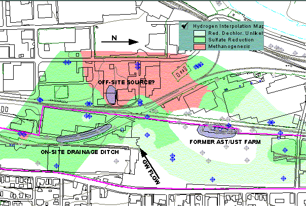 Dissolved Hydrogen Concentrations |
The concentration of dissolved hydrogen can be used as an alternate means of evaluating the potential occurrence of reductive dechlorination. Dissolved hydrogen concentrations of greater than 1.0 nanomoles per liter (nM/l) indicate the probable occurrence of reductive dechlorination, even if the other geochemical indicators as scored above indicate that reductive dechlorination is not likely to be occurring. Specific electron acceptor processes which may be occurring in such a case include sulfate reduction (at hydrogen concentrations of 1 to 4 nM/l) and methanogenesis (at hydrogen concentrations of 5 to 20 nM/l). The figure to the left shows the interpolated grid (using the IDW method) of hydrogen concentrations, indicating that reductive dechlorination, in the form of sulfate reduction or methanogenesis, is likely occurring in the area of interest. |
The new ModelBuilder extension in Esri’s ArcView® Spatial Analyst 2 was used to develop a model to perform the initial screening process described in USEPA’s natural attenuation guidance document. The model was used to evaluate the potential occurrence of natural attenuation processes, specifically reductive dechlorination, at an NPL site in western Pennsylvania.
The results of the model indicate that natural attenuation is potentially occurring in groundwater impacted by chlorinated solvents. Based on these findings, additional site characterization and modeling will be performed to determine if a MNA remedy is appropriate for the site. It is currently anticipated that if MNA is selected for the site, it will be in combination with a source control remedy (product removal from the former tank farm area) and enactment of a municipal ordinance prohibiting the use of groundwater in the vicinity of the site.
U.S. Environmental Protection Agency, Technical Protocol for Evaluating Natural Attenuation of Chlorinated Solvents in Ground Water, EPA/600/R-98/128, September 1998.
Bryan R. Maurer
Senior Project Engineer
Cummings/Riter Consultants, Inc.
339 Haymaker Road
Parkway Building, Suite 201
Monroeville, PA 15146
Phone: (412) 373-5240
Fax: (412) 373-5242
Email: bmaurer@cummingsriter.com
Web: http://www.cummingsriter.com