Development of
generic, reusable ActiveX GIS components based off of Esri’s
ARC/INFO Open Development Environment (ODE).
Timothy Miller,
Eric Songer, Joseph Huss, Micheal McInnis, John Rourke Jr., Mary
Kruck, Leo Salemann, Durwood Gafford, and Steven Prager, Lockheed
Martin Information Systems, Advanced Simulation Center
Abstract
Esri’s ARC/INFO Open
Development Environment (ODE) provided a powerful and flexible
alternative to developing custom applications with AML macros.
Both ODE and AML environments executed the ARC/INFO command line
and provided access to AML functions and directives. Developing
ODE applications as with AMLs still required a good degree of ARC/INFO
and AML experience and was difficult for non-ARC/INFO users to
develop and maintain. A generic set of ActiveX Objects were
created that encapsulated ARC/INFO’s GIS functionality into
groups of classes/objects that would promote ease of use for non-ARC/INFO
users, and still have power, flexibility, and promote reuse for
the traditional GIS users.
Introduction
| The ARC/INFO
Open Development Environment Application Programmer’s
Interface (ARCODEAPI) was developed as a COM/ActiveX
group of objects that provide ARC/INFO command line
functionality for use in developing Microsoft Windows
based applications1. The goal was to create an application
programmer’s interface (API) that promotes ease of
use for non-ARC/INFO users, yet still have power and
flexibility, and provide an alternative to AMLs. ARCODEAPI was implemented using Microsoft Visual
Basic and is packaged as an ActiveX DLL. We chose to
develop ARCODEAPI in Microsoft Visual Basic for several
reasons:
- Esri had already built ARC/INFO
ODE objects based on Visual Basic; we wanted to
reuse/base our object model off this existing
model.
- We have a talented GIS staff with
diverse backgrounds and various degrees of
programming experience. We wanted to choose a
language that was object oriented, robust, and
had a minimal learning curve.
- ARCODEAPI is essentially a wrapper
around the ARC/INFO command line interface. ARC/INFO
is still doing the bulk of the processing and the
compiled speed of the binary API was not a
critical factor.
The ARCODEAPI functionality can be
categorized into four functional areas:
- Data Management Objects –
Manages ARC/INFO Coverages, Grids, Workspaces and
ARC/INFO supported image formats.
- Coverage Objects –
Manipulates and processes ARC/INFO Coverages.
- Raster/Image Objects –
Manipulates and processes ARC/INFO Grids and ARC/INFO
supported images.
- Projection Objects – Projects
ARC/INFO Coverages, Grids, and generic geometric
objects.
|
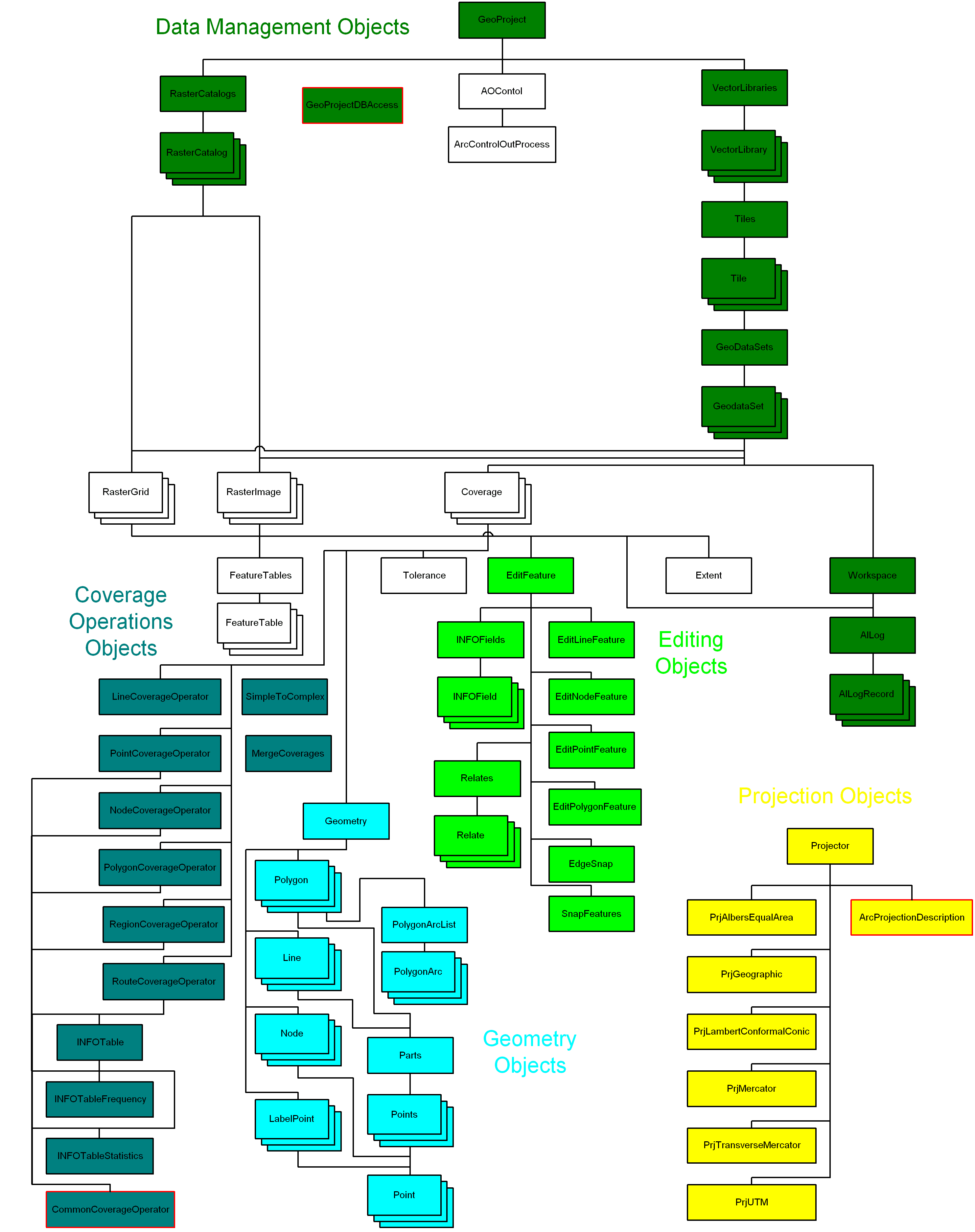
Figure 1 ARCODEAPI
Object Overview
|
Data Management Objects
The data
management objects are designed to create, track, and
manage vector and raster data (ARC/INFO Coverages, Grids,
and supported Image formats). The data management objects
are hierarchical collections. Navigating through the
object hierarchy provides a simple and useful mechanism
for doing repetitive manipulations on large quantities of
spatial data. The following Visual Basic code example
shows how easy it is to provide access to all the
Coverages within a Vector Library Object.
' Loop through all the tiles in the source vector library
For Each SrcTile In SourceLibrary.Tiles
   ' Loop through all of the geodatasets within the tile
   For Each SrcGeoDataSet In SrcTile.GeoDataSets
      ' Loop through all the geodata collected
      For Each SrcObject In SrcGeoDataSet
         ' If the object is type clsCoverage project it
         If TypeOf SrcObject Is clsCoverage Then
            ' Do some thing with the coverage
         End If
      Next SrcObject
   Next SrcGeoDataSet
Next SrcTile
|
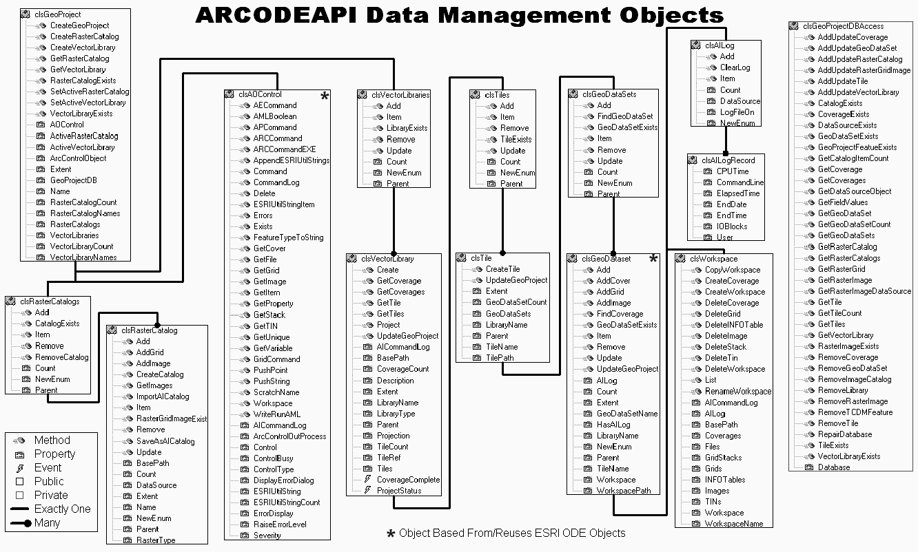
Figure 2 ARCODEAPI Data
Management Objects
|
Internal Data Management
| A Microsoft
Access database (GeoProject Database) is used to
internally track all data objects present in the
ARCODEAPI. The tables are used for saving/retrieving
object persistence and allow searching for specified
objects within the project. As most object properties are
populated upon instantiation, only the properties for
object instantiation, searching, and status are present
in the tables. The ARCODEAPI
objects communicate with the GeoProject Database through
the private GeoProjectDBAccess object. The GeoProjectDBAccess
object is based on Microsoft’s Data Access Object (DAO),
and provides an SQL based mechanism for ARCODEAPI objects
to add, delete, update, and query the tables (see Table 1)
in the GeoProject Database.
|
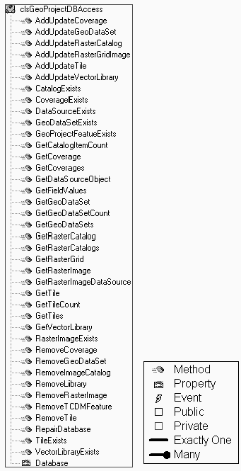
Figure 3
GeoProjectDBAccess
|
Table 1 The GeoProject Database
consists of six tables.
Table Name
|
Table Fields
|
| Coverage
Table |
CoverageName,
CoverageFullPath, XMin, Ymin, Xmax, Ymax, GeoDataSetName,
TileName, LibraryName, CoverageType, EditStatus,
QualityCheck |
| GeoDataSet
Table |
GeoDataSetName,
LibraryName, Count, TileName, WorkspacePath |
| Tile Table |
TileName,
TileFullPath, Xmin, Ymin, Xmax, Ymax, LibraryName,
GeoDataSetCount |
| Vector
Library Table |
LibraryName,
LibraryBasePath, TileCount, Xmin, Ymin, Xmax, Ymax,
TileRef, Description, LibraryType |
| Image Catalog
Table |
ImageCatalogName,
ImageCatalogFullPath, XMin, YMin, Xmax, Ymax, ImageType |
| Image/Raster
Table |
ImageRasterName,
ImageRasterFullPath, Type, Xmin, Ymin, Xmax, Ymax,
ImageCatalogName, GeoDataSetName, QualityCheck |
Raster Data
Management
| Raster data
management is similar to vector data management and uses
the ARC/INFO Image Catalog system, maintaining object
persistence information within the GeoProject Database.
The raster data management consists of two objects, RasterCatalogs
and RasterCatalog, that are used to manage and
track ARC/INFO Grids (RasterGrid object) and
images (RasterImage object) supported by ARC/INFO
(see "Raster/Image Objects"). The RasterCatalog object is analogous to
an individual ARC/INFO Image Catalog and is actually an
object interface to an image catalog. The RasterCatalog
also offers the ability to set the catalog type (e.g., A
catalog can be set to collect TIFF images, and the RasterCatalog
object will only allow TIFFs to added), query the catalog
extents, or see if an image exists within the catalog.
The RasterCatalog object also provides the COM
NewEnum interface to support "For Each" looping
through each image object collected in the RasterCatalog
Object. For example, the following Visual Basic code
converts all images within a RasterCatalog to
Grids and adds them to a new RasterCatalog.
Dim InRasterCatalog As clsRasterCatalog
Dim OutRasterCatalog As clsRasterCatalog
Dim RasterImage As clsRasterImage
' Create a new Catalog
Set OutRasterCatalog = New clsRasterCatalog
OutRasterCatalog.CreateCatalog "C:\data\grids", "MyGrids", _
                               ArcGrid
' Convert the old image to grids and add to the new catalog.
For Each RasterImage In InRasterCatalog
   OutRasterCatalog.Add RasterImage.ConvertToGrid _
                        ("C:\data\grids" RasterImage.ImageName)
Next
The RasterCatalogs object
collects RasterCatalog objects and is used to manage/track
all the RasterCatalog objects (ARC/INFO Image
Catalogs). The following Visual Basic code illustrates
"For Each" looping through the RasterCatalogs
object.
' Loop through all the catalogs being collected in RasterCatalogs
For Each RasterCatalog In RasterCatalogs
   If RasterCatalog.RasterType = ArcGrid Then
      ' Loop through all the Grids in the Catalog
         For Each RasterGrid In RasterCatalog
            ' Do some thing with the grid
         Next
   Else
      ' Loop through all the Images in the Catalog
      For Each RasterGrid In RasterCatalog
         ' Do some thing with the image
      Next
   End If
Next
|
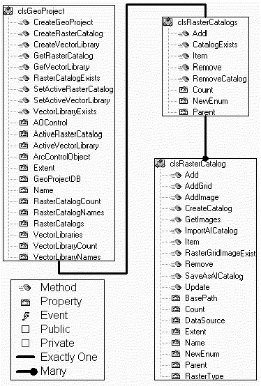
Figure 4 Raster Data Management Objects
|
Vector Data Management
| The vector data
management objects are used to manage ARC/INFO Coverages
(see Coverage Object Section) and Workspaces. ARCODEAPI
manages vector coverages as objects. The object hierarchy
organizes the ARC/INFO Workspaces and Coverages, and
keeps track of where coverages are physically stored.
Workspaces and Coverages can be scattered across various
disks and directory structures and ARCODEAPI organizes
them into a consistent useable hierarchy. Note that
ARCODEAPI is not a wrapper around ARC/INFO LIBRARIAN, but
does support the use of a similar tiling schema and data
hierarchy. The vector data
management object hierarchy consists of:
- VectorLibraries – A
collection object that holds VectorLibrary
Objects;
- VectorLibrary – An
instance of a single Library;
- Tiles – A collection
object that holds all the tiles of a VectorLibrary;
- Tile – An instance of
a single tile within a Library;
- GeoDataSets – A
collection object that holds multiple GeoDataSet
objects, and;
- GeoDataSet – A
collection object that holds ARC/INFO GeoData:
Coverages, Images, and Grids.
|
VectorLibraries / VectorLibrary
| The GeoProject
object (the top of the object model hierarchy)
contains a VectorLibraries object. VectorLibraries
is a collection object that provides general collecting
capabilities and "For Each" looping of VectorLibrary
objects. The VectorLibrary
object provides an interface for creating, querying, and
manipulating data within a Vector Library. The primary
purpose of the VectorLibrary object is to provide
access to the tiled data. The tileddata can be accessed
through various Get-Methods (GetCoverage, GetCoverages,
GetTile (by name), or GetTiles (by extent), or through
the Tiles property. Other methods include:
- Project – projects an entire
Vector Library; and
- UpdateGeoProject – saves the
current VectorLibrary properties to the
GeoProject Database (present in all objects that
have an associated entry within the GeoProject
Database).
The VectorLibrary object also
provides information/metadata about the library: number
of tiles, number of coverages, spatial extent, the
projection, and other textual information (Library Name
and Library Description).
|
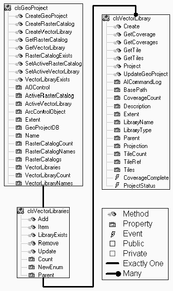
Figure 5 VectorLibraries
/ VectorLibrary Objects
|
Tiles / Tile
| The Tiles
collection object provides general collecting
capabilities and "For Each" looping of the Tile
Object. The Tile objects
primary purpose is to hold the GeoDataSets
collection object and provide information/metadata about
the tile.
|
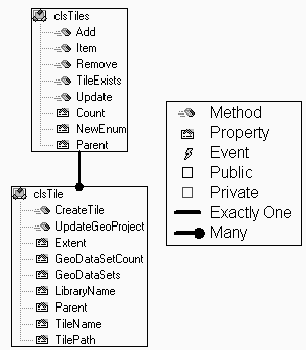
Figure 6 Tiles / TileObjects
|
GeoDataSets / GeoDataSet
| The GeoDataSets
collection object provides general collecting
capabilities and "For Each" looping of GeoDataSet
objects. The GeoDataSet
object is the primary spatial data collection object. Its
main purpose is to collect ARC/INFO Coverages; However,
it is also capable of collecting ARC/INFO Grids and
Images. As a general collection object it provides
properties and methods for managing the objects within
the collection. The GeoDataSet object can be used
to collect data from various ARC/INFO Workspaces or can
be tied to an individual Workspace. When the GeoDataSet
object collects data from a single ARC/INFO Workspace the
AILog and Workspace objects are
instantiated.
The AILog collection object
collects AILogRecord objects, and has methods for
adding comments and clearing the ARC/INFO log file. The AILogRecord
object contains properties for each item in the ARC/INFO
log, and for each row in a log, an AILogRecord
object exists.
The Workspace object provides
properties and methods for managing and manipulating ARC/INFO
Workspaces. This includes:
- The ability to create, delete,
copy, and rename ARC/INFO Workspaces;
- The ability to create new
Coverages;
- The ability to delete ARC/INFO
Coverages, Grids, TINs, Stacks, and INFO tables;
and
- The ability to list Workspace
Coverages, Grids, TINs, Stacks, Files, and Images.
|
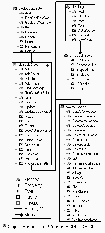
Figure 7 GeoDataSets
/ GeoDataSet Objects
|
Coverage Objects
The Coverage
object provides information/metadata and functionality to
manipulate ARC/INFO Coverages. The Coverage object
is based on Esri’s ODE Coverage object and
has been augmented to provide additional functionality.
The Coverage object provides access to four groups
of objects:
- Esri’s ODE Coverage Level
Objects,
- Coverage Operation Objects,
- Editing Objects, and
- Coverage Geometry Objects.
|
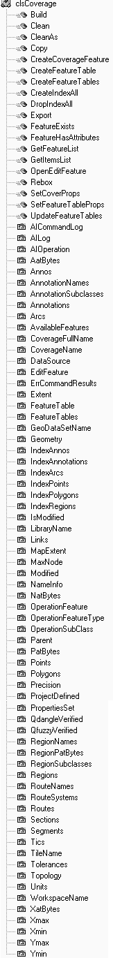
Figure 8 Coverage Object
|
Esri’s ODE Coverage Level
Objects
| The coverage
level objects: FeatureTables, FeatureTable,
Tolerance, and Extent are all based on the
Esri ODE objects. With the exception of the Tolerance
object, the objects have additions and interface
modifications. For Example, the FeatureTables
object had the NewEnum interface added to support "For
Each" looping of FeatureTable objects, and
the Extent object has additional interfaces for
geometric bounding area checks. The FeatureTable
object has a new INFOFields property that provides access
to the coverage’s attributes through the items in
the table (see Editing Objects). |
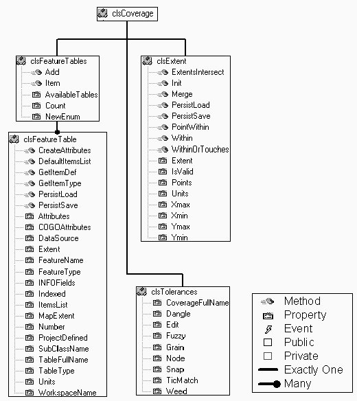
Figure 9 Coverage Level
Objects
|
Coverage Operation Objects
| The coverage
operation objects are a group of objects that provide
functionality to execute Coverage level operations that
are otherwise available at the ARC command prompt. The
operation objects are divided by geometric feature class
type: Line (LineCoverageOperator), Polygon (PolygonCoverageOperator),
Node (NodeCoverageOperator), and Point (PointCoverageOperator).
Three other objects allow manipulation of the coverage’s
INFO tables: INFOTable, INFOTableFrequency,
and INFOTableStatistics. Common functionality that
is present in more than one of the coverage operation
objects is coded in a private object (CommonCoverageOperator)
and exposed publicly in the operations objects. The OperationFeatureType property in the Coverage
object establishes which operations object will be
available through the AIOperation property. For Example,
the following Visual Basic code will buffer a line
coverage:
Dim Coverage As ARCODEAPI.clsCoverage
Dim BufferCov As ARCODEAPI.clsCoverage
Set Coverage = New ARCODEAPI.clsCoverage
Coverage.DataSource = "C:\Data\Roads"
'  Buffer the roads
Coverage.OperationFeatureType = Arc
Set BufferCov = Coverage.AIOperation.Buffer(OutputDataSource:= _
                                            "C:\Data\RoadBuf", _
                                            BufferDistance:=10)
As soon as the coverage datasource
property is set, the coverage object updates all relevant
coverage properties. Then, the OperationFeatureType is
set to arc, causing the AIOperation property to be set to
instantiate and bind to the LineCoverageOperator object.
The above methodology results in a
highly flexible data structure that can be dynamically
reconfigured depending on the type of coverage operation
desired. If, for example, the user wishes to build and
manipulate node topology for the original Arc coverage,
the OperationFeatureType is set to node and the
appropriate commands are invoked via the Coverage.AIOperation
property.
|
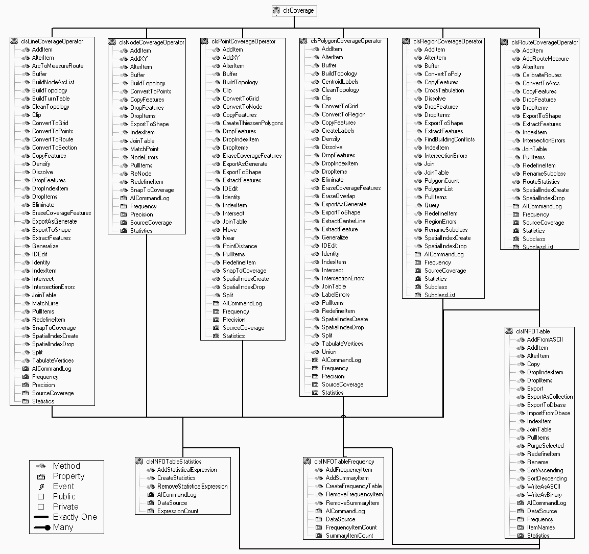
Figure 10 Coverage
Operation Objects
|
Editing Objects
| Coverage
editing objects are a group of objects that provide
ARCEDIT functionality to ARCODEAPI. The EditFeature
object is the primary access point for using the Edit
objects. The EditFeature object provides the
properties and methods for controlling (selecting,
unselecting, deleting, etc.) and manipulating the
features that are being edited. Either Coverage features
or INFO table records may be edited. Depending on the
specified editfeature, the EditFeature objects
bind the appropriate object from the group of objects for
manipulating geometric features: EditLineFeature, EditPolygonFeature,
EditPointFeature, and EditNodeFeature.
These objects provide functionality to move, copy, create,
and edit features (Lines, Points, Nodes and Polygons).
The EditFeature objects also provide functionality
for controlling the relate (Relate and Relates
objects) and snapping (EdgeSnap and SnapFeatures
objects) environments within ARCEDIT and provide item
definitions for INFO Tables (INFOField and INFOFields
objects). The Coverage
object has an OpenEdit method that opens the Coverage for
editing and sets the edit feature within ARCEDIT (similiar
to the commands, Edit <Coverage>; Editfeature <feature
type> in ARCEDIT). OpenEdit also populates the
properties in the EditFeature object. The Feature
property with the EditFeature objects can be set
to expose the EditLineFeature, EditPolygonFeature,
EditPointFeature, or EditNodeFeature objects
through which editing will be accomplished.
Like the coverage operation objects
above, the edit objects are also highly flexible and can
be dynamically reconfigured at any point in the operation.
The following is an example of Visual
Basic Code to edit an arc coverage.
|
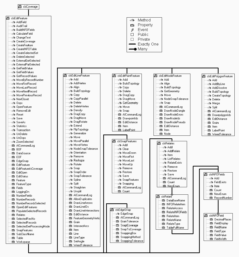
Figure 11 Coverage Edit
Objects
|
Dim Coverage As ARCODEAPI.clsCoverage
Set Coverage = New ARCODEAPI.clsCoverage
Coverage.DataSource = "C:\Data\Roads"
Call Coverage.OpenEditFeature(Arc)
Coverage.EditFeature.SelectedSetProcessingMode = SelectMode_Cursor
' Select all roads of type 2, Paved.
Call Coverage.EditFeature.CreateSelectedSet("SELECT ROAD-TYPE = 2")
' If no feature are paved exit.
If Coverage.EditFeature.NumberRecordsSelected = 0 Then
   Coverage.EditFeature.RemoveEdit
   Exit Sub
End If
' Loop through each feature in the selected set and generalize
Do While Not Coverage.EditFeature.EOF
   With Coverage.EditFeature
      Call .Feature.Generalize(Feature.Item("Width") * 0.00045 * _
            Feature.Item("Length"), Enum_GeneralizeMethod.BendSimplify)
      .MoveNextRecord
   End With
Loop
Coverage.EditFeature.Save
Coverage.EditFeature.RemoveEdit
|
Coverage Geometry
Objects
| The geometric
objects provide read only access to the Coverage's
geometry, and are accessed through the Geometry property
within the Coverage object. The Geometry
object provides methods to return a collection of
geometric objects: Node, Point, Line,
or Polygon. The Node, Point, Line,
and Polygon objects then contain groups of
primitive geometric objects that actually contain
coordinate information. The primitive geometric objects
are modeled after Esri's MapObjects geometric objects (Parts,
Points, Point). This mimicking of
MapObjects objects allows generic geometric methods to be
reused with both the ARCODEAPI and Esri's MapObjects. The following Visual Basic code writes an ARC/INFO
ASCII Generate file using the Geometry Objects:
Dim Coverage As ARCODEAPI.clsCoverage
Dim Line As ARCODEAPI.clsLine
Dim Point As ARCODEAPI.clsPoint
Dim TextStream As Scripting.TextStream
Dim FileSys As Scripting.FileSystemObject
Set Coverage = New ARCODEAPI.clsCoverage
Set FileSys = New Scripting.FileSystemObject
Set TextStream = FileSys.OpenTextFile("C:\data\road.gen", _
                                      ForWriting, True)
Set FileSys = Nothing
Coverage.DataSource = "C:\data\road"
Call Coverage.Geometry.GetGeometry(ArcLine)
For Each Line In Coverage.Geometry
   TextStream.WriteLine Line.ARCID
      For Each Point In Line.Parts.Item(1)
         TextStream.WriteLine Point.X &  " " & Point.Y
      Next
   TextStream.WriteLine "END"
Next
TextStream.WriteLine "END"
TextStream.Close
|
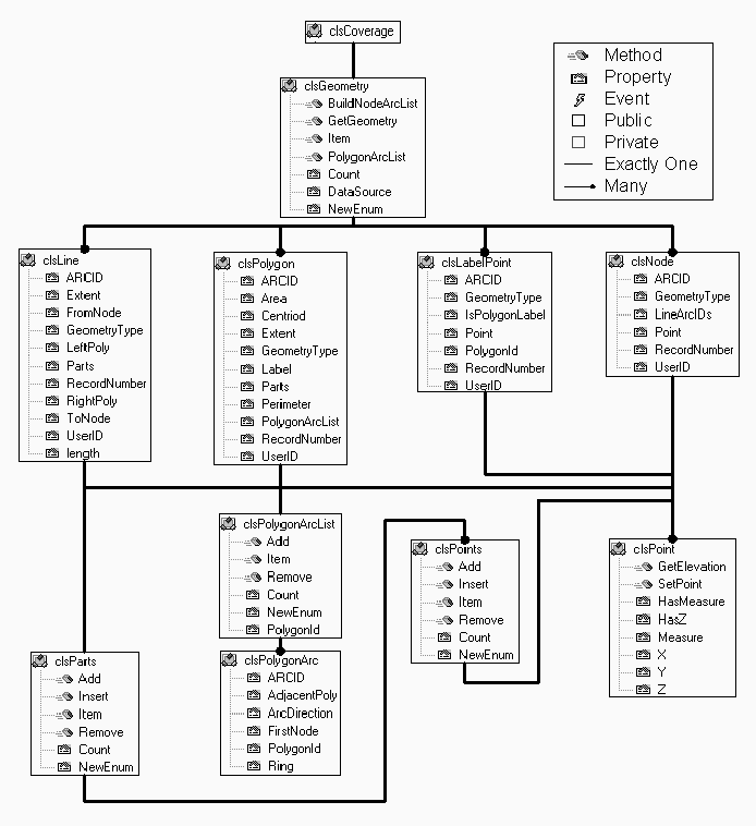
Figure 12 Coverage Geometric Objects
|
Other Coverage
Operations
| Two other
coverage level operator objects are available, but are
not associated with the object hierarchy: MergeCoverages
and SimpleToComplex. The MergeCoverages
object is a wrapper around the Arc Append command. The
object collects Coverage objects that will be merged with
the Arc Append command. SimpleToComplex is used
for merging Coverages with Arc features to a Coverage
with Route features, and Coverages with Polygon features
to a Coverage with Region features. |
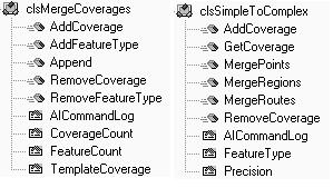
Figure 13 Other Coverage
Operations Objects
|
Raster/Image Objects
| ARCODEAPI’s RasterGrid
and RasterImage objects are extended versions of
Esri’s ODE Grid and Image objects.
Additional functionality has been added. |
Raster Grid Object
The RasterGrid
object has several interface changes:
- Properties were added to track RasterCatatlog
or GeoDataSet objects;
- Properties were added for ??ERROR??
handling and processing.
- Methods were added to support
import and export in several formats;
- Methods were added to manipulate
Raster Grid extents (Clip, Flip, and Shift).
RasterGrid Code Example:
' Converts a USGS DEM to an GRIDASCII file.
Dim Grid As ARCODEAPI.clsRasterGrid
Dim Workspace As ARCODEAPI.clsWorkspace
Set Grid = New ARCODEAPI.clsRasterGrid
Set Workspace = New ARCODEAPI.clsWorkspace
Workspace.Workspace = "F:\Workspace"
Grid.ImportUSGSDEM("F:\Workspace\d45112.dem", _
                   "F:\Workspace\d45112") _
                  .ExportASCII "F:\Workspace\d45112.asc"
Workspace.DeleteGrid "d45112"
|
Figure 14 RasterGrid
Object
|
Raster Image Object
Several
interface changes were made to the RasterGrid
object:
- Properties were added to track RasterCatatlog
or GeoDataSet objects;
- Properties were added for handling
and processing; and
- The interface to FeatureTables/FeatureTable
was removed.
While the Raster Image object is
redundant in many regards, it does provide a specialized
environment specifically dedicated to managing images.
The overhead associated with managing raster grids is not
present, and the image objects are thusly optimized as
they pass through the system.
|
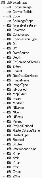
Figure 15 RasterImage
Object
|
Projection Objects
| The
projection objects provide the functionality to project
ARC/INFO Coverages , Grids, and the Points and Point
geometric objects. To accomplish this, the projection
definition object must be able to store and manipulate
projection parameters. Currently, six projection
definition objects exist: (1) Geographic, (2) UTM, (3)
Albers Equal Area, (4) Lambert Conformal Comic, (5)
Transverse Mercator, and (6) Mercator. The Projector
object uses the projection definition object to construct
the proper project parameters before projecting
GeoDataSets. Visual Basic code
example for projection an ARC/INFO Coverage:
Dim Coverage As ARCODEAPI.clsCoverage
Dim PrjCoverage As ARCODEAPI.clsCoverage
Dim Projector As ARCODEAPI.clsProjector
Dim InputPrj As ARCODEAPI.clsPrjGeographic
Dim OutputPrj As ARCODEAPI.clsPrjLambertConformalConic
Set Coverage = New ARCODEAPI.clsCoverage
Set Projector = New ARCODEAPI.clsProjector
Set InputPrj = New ARCODEAPI.clsPrjGeographic
Set OutputPrj = New ARCODEAPI.clsPrjLambertConformalConic
Coverage.DataSource "D:\Data\roads"
' Set the input projection parameters.
InputPrj.Datum = Datum_WORLDGEODETICSYSTEM_1984
InputPrj.Spheroid = Spheroid_WorldGeodeticSystem_1984
InputPrj.Units = MapUnits_DecimalDegrees
' Set the ouyput projection parameters.
OutputPrj.Datum = Datum_WORLDGEODETICSYSTEM_1984
OutputPrj.Spheroid = Spheroid_WorldGeodeticSystem_1984
OutputPrj.Units = MapUnits_Meters
OutputPrj.CentralMeridian = -114
OutputPrj.FirstStandardParallel = 40
OutputPrj.SecondStandardParallel = 44
OutputPrj.LatitudeOfOrigin = 44
OutputPrj.FalseEasting = 500000
OutputPrj.FalseNorthing = 500000
' Project the coverage.
Set Projector.InputProjection = InputPrj
Set Projector.OutputProjection = OutputPrj
Set Projector.GeoDataSource = Coverage
Projector.Precision = DoublePrecision
Set PrjCoverage = Projector.Project("D:\Data\roads")
Again, the extensibility of the system
is evident. If support for additional projection types is
desired, only a new projection definition object is
required. Furthermore, the enumerated projection types
ensure that the choices available to the programmer are
predetermined, preempting the possibility of selecting a
projection that is not supported.
|
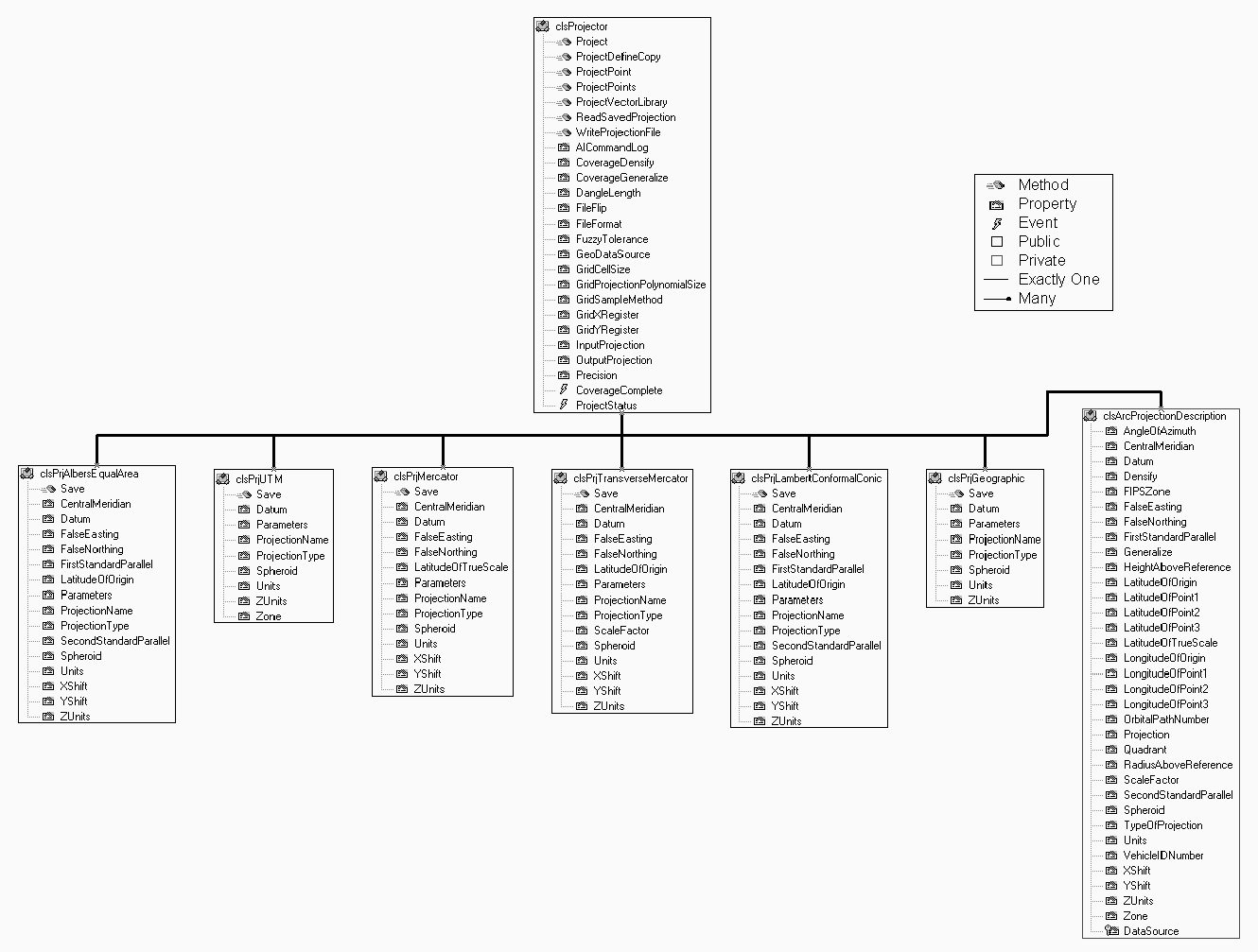
Figure 16 Projection
Object
|
Conclusion
ARCODEAPI provides an object oriented
collection of data and methods that encapsulates much of the
functionality of the ARC/INFO command line interface. The
ARCODEAPI interface can be used to develop Microsoft Windows
applications and tools, and provides a relatively simple object
model wherein GIS and non-GIS developers can easily develop
applications that take advantage of the Esri Open Development
Environment.
Acknowledgements
ARCODEAPI - development was funded through
Contract N61339-95-C-0051.
ARCODEAPI is Copyrighted: (c) 1999-2000 (Copyright
held jointly by: Lockheed Martin Corporation; Dynamics Research
Corporation; Logicon, Inc.; Science Applications International
Corporation; Sterling Software, Inc.) Unlimited rights held by US
Government pursuant to Contract N61339-95-C-0051
ARCODEAPI DISTRIBUTION STATEMENT: DISTRIBUTION
AUTHORIZED TO THE DEPARTMENT OF DEFENSE AND U.S. DoD CONTRACTORS
ONLY DUE TO CRITICAL TECHNOLOGY, EFFECTIVE 20 JUNE 1994. OTHER
REQUESTS SHALL BE REFERRED TO THE PCO.
End Notes
1. Development of the Terrain Data Fusion
System (TDFS) for Creation of Constructive Simulation Databases.
Twentieth Annual Esri International User Conference Paper 796
Author Information (Design/Development Team)
| Timothy
Miller Lockheed Martin
Information Systems
1182 Hegson Drive
Stevensville, MT 59870
Telephone: 406-777-6039
Fax: 425-746-1335
Email: tmiller@lads.is.lmco.com
|
Micheal
McInnis Lockheed Martin
Information Systems
3605 132nd Ave. S.E., Suite
400
Bellevue, WA 98006
Telephone: 425-957-3248
Fax: 425-746-1335
Email: mmcinnis@lads.is.lmco.com
|
Leo
Salemann Lockheed Martin
Information Systems
3605 132nd Ave. S.E., Suite
400
Bellevue, WA 98006
Telephone: 425-957-3285
Fax: 425-746-1335
Email: lsaleman@lads.is.lmco.com
|
| Eric
Songer Lockheed Martin
Information Systems
3605 132nd Ave. S.E., Suite
400
Bellevue, WA 98006
Telephone: 425-957-3225
Fax: 425-746-1335
Email: esongers@lads.is.lmco.com
|
John
Rourke Jr. Lockheed Martin
Information Systems
3605 132nd Ave. S.E., Suite
400
Bellevue, WA 98006
Telephone: 425-957-3241
Fax: 425-746-1335
Email: jrourke@lads.is.lmco.com
|
Durwood
Gafford Lockheed Martin
Information Systems
3605 132nd Ave. S.E., Suite
400
Bellevue, WA 98006
Telephone: 425-957-3219
Fax: 425-746-1335
Email: dgafford@lads.is.lmco.com
|
| Joseph
Huss Lockheed Martin
Information Systems
3605 132nd Ave. S.E., Suite
400
Bellevue, WA 98006
Telephone: 850-894-3242
Fax: 425-746-1335
Email: jhuss@lads.is.lmco.com
|
Mary Kruck Lockheed Martin Information Systems
3605 132nd Ave. S.E., Suite
400
Bellevue, WA 98006
Telephone: 425-957-3262
Fax: 425-746-1335
Email: mkruck@lads.is.lmco.com
|
Steven D.
Prager *
6102 Olympic Dr. NE
Tacoma, WA 98422 Telephone: 425-957-3290
Fax: 425-746-1335
Email: sdprager@sfu.ca
|
* Contractor