Authors: Vincent P. Greenwade, Alexis R. Alicea
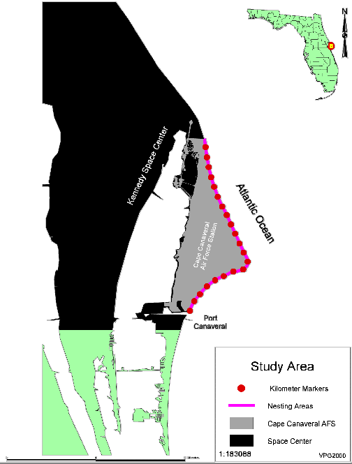
The Cape Canaveral Air Force Station (CCAFS) includes 21 kilometers of Atlantic coastal beach along the eastern seashore of Florida. This area provides a prime nesting habitat for threatened and endangered sea turtles. GIS technology is currently being used to determine areas of concern and to assess the impacts of new and current Air Force Operations. This paper addresses a series of management strategies that are designed to protect sea turtles and their nests, and document the effectiveness of these efforts.
The Endangered Species Act of 1973 requires Federal agencies to protect and conserve threatened and endangered species. The U.S. Air Force initiated a program for conservation of nesting marine turtles in 1984. The program involves the protection, conservation, and management of threatened and endangered sea turtles and their nests.
Since 1988, the station has been collaborating with the Florida Department of Environmental Protection (FDEP)'s Index Nesting Beach Survey. This survey was designed to provide an index of sea turtle population trends through standardized sampling of selected nesting beaches across the state.
In 1998 the U.S. Air Force 45th Space Wing Environmental Flight funded Vista Technologies and the Dynamac Corporation under the Environmental Support Contract (ESC) to manage day to day environmental concerns on CCAFS. ESC currently employs the use of GIS to analyze historical and current year nest density, predatory disturbances to sea turtle nests, and the effects of space industry operations on nesting turtles and hatchlings.
Kennedy Space Center borders the station to the north and Port Canaveral borders to the south (Figure 1). The beach is characterized by a high-energy surf zone, a gently sloping sandy beach along most of the property with a subsection at the north that is low energy. Because CCAFS is a secured base, there is no public access to beach areas. This along with limited beachfront development and no armoring makes the beaches on CCAFS prime nesting habitat for threatened and endangered sea turtles.
During the nesting season, data are collected on total number of nests deposited, species composition, number of marked nests by kilometer, and the fate of nests deposited. In 1998, field biologists began marking a sub-sample of loggerhead nest per kilometer per week and all green and leatherback nest using numbered wooden survey stakes.
By using GIS, these data can be modeled as a collection of discrete features in vector format. The vector data are overlaid on raster images used as background or base maps. Tabular data are linked via Open Database Connectivity (ODBC) driver to the sea turtle nesting analysis tool. This allows biologists to continue to use and update their data in more familiar office productivity software (i.e. Excel or Access).The tables from these applications are linked to line feature that represent kilometers of nesting beach. Queries are then run on the linked tables. The resulting data are then overlaid as line features that represent the queried data.
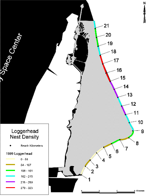
For example, in 1999 the loggerhead (Caretta caretta) nesting season was characterized by a record number of nests. That season resulted in a total of 6,986 loggerhead crawls, of which 3,581 resulted in nests. When the nest data is applied to nesting area line feature and then broken down by kilometer (Figure 2), the result is a line feature that shows the density of nests deposited by kilometer using a graduating color to denote density breaks.
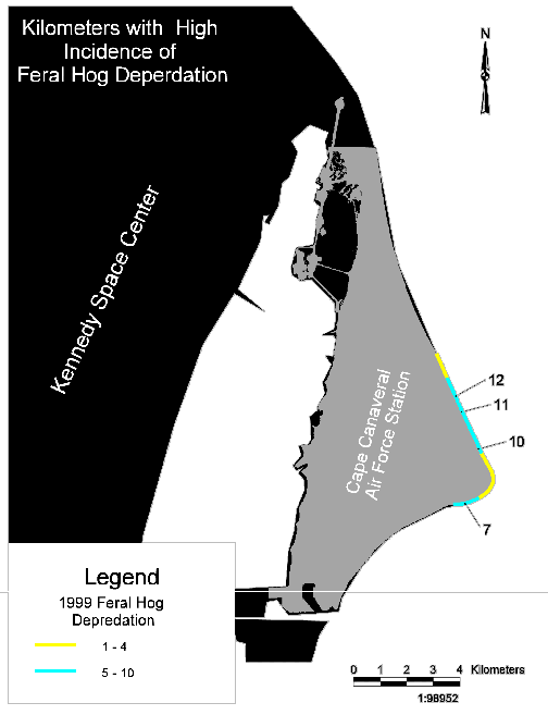
During the nesting season data are collected on the fate of marked nests. Depredation of sea turtle nests by raccoons and feral hogs have been a continuous problem on CCAFS. Currently, there are two methods of predator control and nest protection that have proven to be effective. The first method is the use of predator screens. The second and primary method of nest protection and predator control is through live trapping. These methods are put in place prior to and during the nesting season.
In 1999, raccoons accounted for the depredation of 22.9% of the 450 loggerhead nests marked that year. In the same year depredation by feral hogs accounted for 10% of marked nests. By using the GIS, biologists can analyze data collected on the fates of marked nests and use the spatial display to evaluate kilometers that where hit hardest by predators.
For example, in 1999 the majority of marked nests depredated by raccoons were located in kilometers 2, 3, 5, and 18 (Figure 3). This information was applied to the GIS tool designed for sea turtle nesting analysis, much the same way the nest deposit and false crawl data. When the vector data are overlaid on the base map, a visual representation of the number of marked nest depredated by raccoons along the nesting beach is displayed. . The vector data in Figure 4 shows the beach kilometers that encountered nest disturbances by feral hogs and the areas of highest concentration of these disturbances.
By using GIS as an analysis tool, field biologists can get a visual representation of the data as it relates to kilometers of beach. In the case of nest depredation, biologists can map trends by kilometer of beach. This analysis can then be re-applied in the field to help curb the incidence of nest depredation by sea turtle nuisance animals.
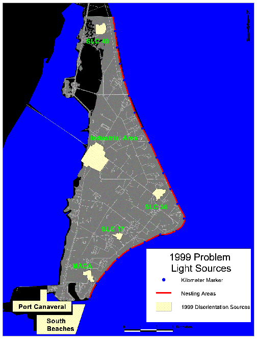
Disorientation of sea turtle hatchlings and nesting females due to exterior lighting on CCAFS has been a significant problem in the past. In 1988, the US Air Force and the US Fish and Wildlife Service agreed upon the development of light management plans for CCAFS, in order to comply with section 7 of the Endangered Species Act. The purpose of these plans are to provide site specific guidelines for identification, management recommendations and operational guidelines for lights which are known to adversely affect sea turtle nesting activity.
Hatchling disorientation data are collected on the nests that have been marked for study. In the past, areas of CCAFS, KSC, and Port Canaveral had an adverse effect on hatching sea turtles. The light "glow" from nighttime operations would confuse hatching turtles and cause them to crawl inland towards the artificial light sources instead of towards the ocean.
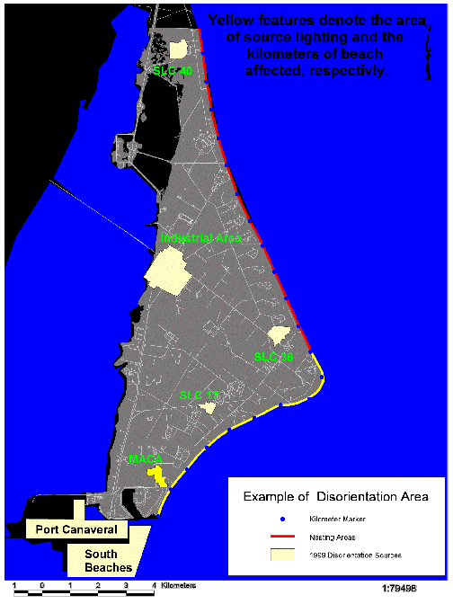
In the field, biologists identify areas that may cause the disorientation of turtle hatchlings. The biologists make a general assessment on light sources that may have had an impact on turtle hatchlings the previous evening, based on the direction of hatchling tracks (or footprints). Biologists use GIS to visually display zones of concern on CCAFS and adjoining areas. Figure 5 displays the areas of concern during the 1999-nesting season. Seven areas were identified where light from nighttime operations may have caused disorientation events. Five of these areas are on CCAFS property. The other two, are areas to the south of the Air Station.
In addition to identifying areas of concern, biologists also use the disorientation data to identify kilometers that were affected by each light source. Figure 6 shows an example of field data collected during hatchling emergence. It pointed out light sources from operations at the MACA area, an area that may have contributed to hatchling disorientation in the 9 kilometers of southern beach on CCAFS. The GIS data was applied to a spatial application and presented in a 1999 section 7 consultation with USFWS.
The use of GIS in conjunction with field data can help make assessments on areas that are critical for sea turtle nesting. GIS has proven to be an excellent tool for the biologists of the Environmental Support Contract. As more questions arise from the study of sea turtles and their nesting habitat, the future of GIS for use in the analysis of sea turtle nesting areas are endless. Field biologists can employ the use of Global Position satellites to get nest locations and density in relation to nesting beach profile. By graphically representing the field data biologists can present data compiled over the years in a simple and easy to understand format so that management decisions are more easily obtained.
Alicea,A., A. Chambers, K. Herpich, and J. Provancha. , 1999 Sea Turtle Nesting Summary Report Cape Canaveral Air Force Station, Florida. Environmental Support Contract, Cape Canaveral Air Force Station, FL, October 1999
Zeiler, Michael, Modeling Our World: The Esri Guide to Geodatabase Design. Redlands, CA: Environmental Systems Research Institute, Inc. Publisher, 1999
Thank you to Jane Provancha and the ESC Natural and Cultural Resource staff for their continued support and encouragement. It is their hard work and countless hours of data collection that keeps the GIS department in business.
Vincent P. Greenwade
Information Services Specialist
Dynamac Corporation
Environmental Support Contract
Alexis Alicea
Environmental Scientist
Dynamac Corporation
Environmental Support Contract