Tiffany L. Turner, MCP and Rick T. Bowers, PE
ArcIMS – The Solution to Streamlining Data Collection, Modeling, Planning and Design.
ABSTRACT
The U.S. Environmental Protection Agency (EPA) has found that sanitary sewer overflows (SSOs), caused by poor sewer collection system management, pose a substantial health and environmental challenge in our country. The City of Clearwater, Florida (the City) is one of the first municipalities in the country to conduct an audit of their sanitary sewer system under the mandated Management, Operations and Maintenance (MOM) Program. To assist the city, TBE Group (TBE) and Business Technologies of Central Florida, Inc. (BTCFI) are developing a pilot ArcIMS application to streamline data collection, modeling, planning and design efforts of the sanitary sewer system. The application allows field technicians, surveyors and engineers to review, comment and redline the sanitary sewer data on-line.
BACKGROUND
Under the MOM Program, EPA Region 4 asks permitted wastewater utilities, and any associated satellite utilities, to perform a detailed audit of the management, operation, and maintenance programs associated with their facilities. Participants provide a report, which includes the audit results, any improvements that can be made, and any schedules necessary to make those improvements. By self-disclosing any needed improvements, the participants can be eligible for significantly less, and in some cases eliminated, civil penalties while under a remediation schedule, often their own. The ultimate goal of the MOM Program is to eliminate SSOs from the collection system.
EPA asks that the owners of the permitted wastewater utilities inventory and map its collection system and plant service areas to include at a minimum,
- Gravity lines: Linear feet by diameter
- Manholes: Number
- Pump stations: Number by type
- Fore Mains: Linear feet by diameter
- Air release valves: Number and location
- Inverted syphons: Number and location
- Other major appurtenances: Number and location
- Service population: By facility service area
GIS, Esri's ARC/INFO and ArcIMS, is the perfect tool to perform this task.
The City elected to perform a self-audit of its sanitary sewer system to comply with EPA’s MOM Program. TBE and its sub-consultants were tasked to
- Collect and review all available digital and hardcopy information on the wastewater collection, transmission and treatment systems
- Collect rainfall and flow meter data and perform smoke tests on the collection system to locate the defects and illegal connections
- Develop a calibrated hydraulic model of the City’s sanitary sewer system and run various storm events to see where SSOs were occurring because of restrictions in the system
- Design cures for the SSOs
- Develop detailed GIS datasets, atlas sheets, and an ArcIMS application to facilitate the inventorying, modeling, planning, and design efforts of the wastewater system
|
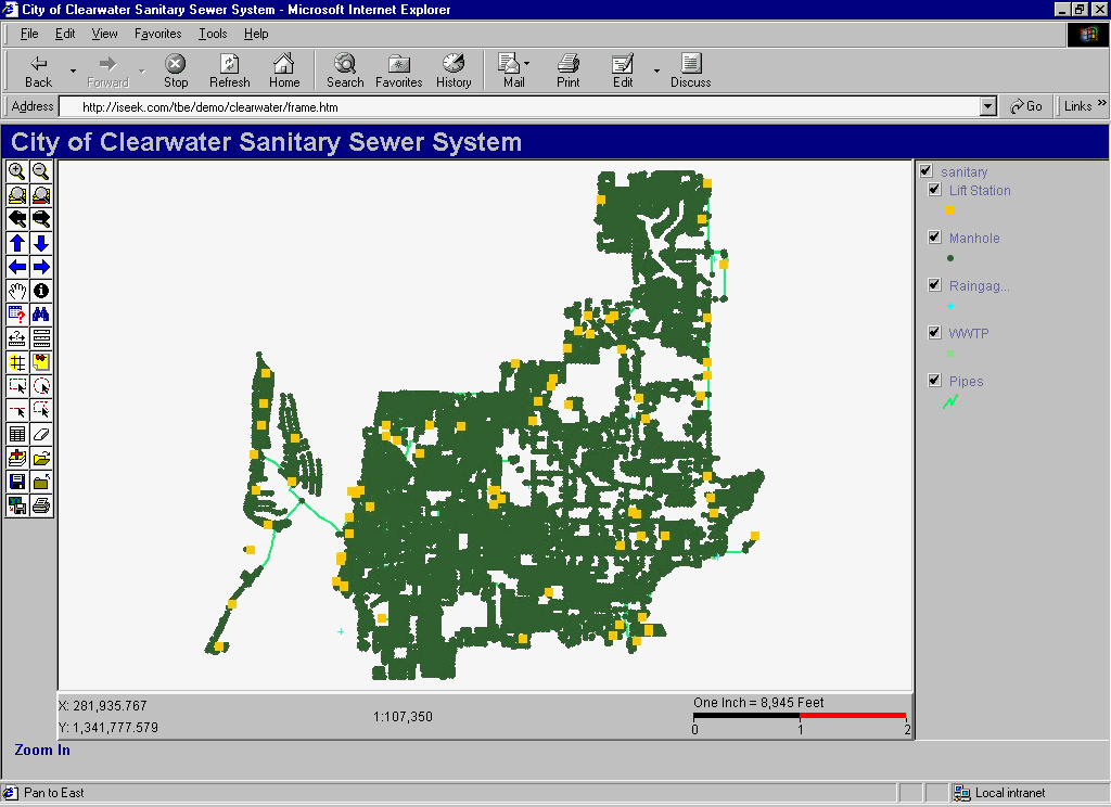
The City of Clearwater is located in central Pinellas County, Florida, on Florida’s west coast as shown to the right. The City’s wastewater system consists of approximately 388 miles of gravity sewer and force main piping, 8,500 manholes, 75 pumping stations and three (3) advanced wastewater treatment facilities (AWTF). Shape files of all these systems were created and imported into ArcIMS. INTRODUCTION ArcIMS is the latest commercial-off-the-shelf internet GIS software provided by Environmental Systems Research Institute (Esri). This software allows the developer to serve complex mapping and querying tools on-line without customized programming. ArcIMS is comprised of four on-line "wizards": Administrator, Designer, Author and Manager. These "wizards" provide the developer with quick point and click routines that create your on-line GIS application, as opposed to weeks of customized and labor intensive programming. Additionally, ArcIMS has the flexibility to allow customized programming through JavaScript. In short, the power of ArcIMS lies in its ability to quickly integrate your on-line GIS with the rest of your web site that uses other common internet programming languages, revolutionizing web-enabled GIS applications. |
 |
The sections that follow discuss the situation and approach of each component of
the City's Sanitary Sewer Evaluation Master Plan (SSEMP) and MOM project, data collection, modeling, planning and design, and the pilot ArcIMS
application developed to assist with these efforts.
DATA COLLECTION
The challenge of any large and complex modeling, planning and
design project is to collect reliable data and compile a complete database. This
was the case for the City’s SSEMP and MOM
project. The project team started with reliable digital files documenting the
system network location. The pipe invert and rim elevations, pipe diameter, pump
station and other key pieces of data needed for hydraulic modeling was
approximately 40 percent complete. Knowing a more complete database was needed
to develop a reliable calibrated hydraulic model and eventually a master plan,
TBE and BTCFI developed a pilot ArcIMS application to assist the project team
with collecting and completing the sanitary sewer database in an effective and
timely manner.
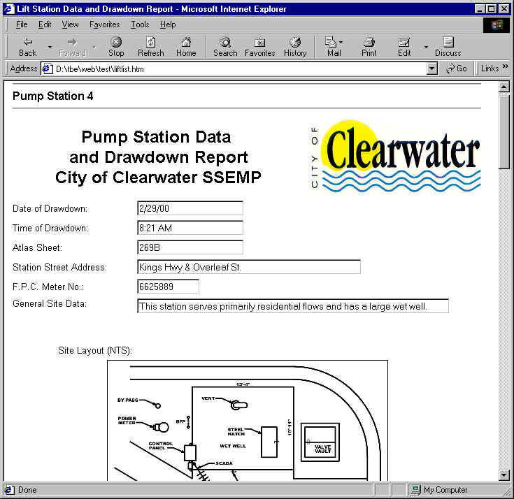
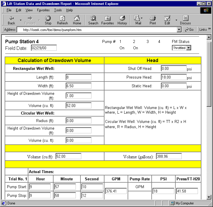
Historically, municipal surveyors and field technicians use
conventional surveying techniques to gather field data. This process can be time
consuming and possibly unreliable depending upon how many people handle the data
and varying interpretations. This is where the ArcIMS application comes into
play. The surveyors and field technicians can view and input the sanitary sewer
data on-line. The approach includes:
- Obtain equipment and verify services prior to going into the field. These include:
- Global Positioning System (GPS) unit
- Laptop with modem
- Internet connection via cell phone
- Internet Service Provider
- Web cam
- Digital camera
|
|
The ability to provide real-time field information provides the team with timely and correct data, gets the data into the database quicker, and provides the team with a permanent digital record of the field notes. For example, before the ArcIMS application went on-line, it took 2 to 4 weeks for the surveyors to submit the survey data and field notes to the project team. Once on-line, the surveyors could submit the survey data daily in a digital format. These are just a few of the benefits using ArcIMS to gather field data and share information with the project team. |
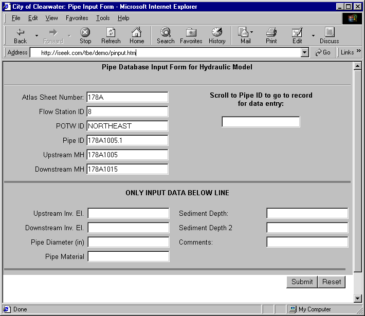
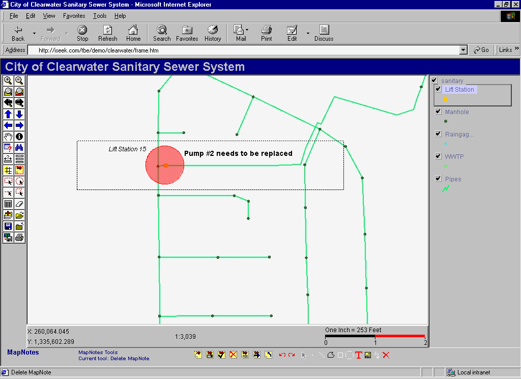
MODELING, PLANNING AND DESIGN
The ArcIMS application allows the engineers to view, query
and comment on the hydraulic modeling results, planning and design cures
on-line. The GIS-compatible hydraulic model was populated with the data gathered
and compiled from the process discussed above. The model was calibrated from the
flow meter data recorded in the field. The results were saved to a shapefile and
loaded into the ArcIMS application for review, query and comment by the
engineers and city.
By having the results of the hydraulic model on-line, this
allows the engineers to see the results immediately; therefore, expediting the
planning and design cures for the SSOs in the system. The ArcIMS application
also allows the city to view the project’s progress on a daily basis.
CONCLUSION
The continuing advancements in computer technology is greatly
impacting the GIS and engineering fields. With the popularity and familiarity of
the internet, ArcIMS will become commonplace. Municipalities, using ArcIMS and
its associated applications on the web, will
Lastly, the applications developed with this pilot ArcIMS project can easily be modified and used for other infrastructure systems, such as potable water, stormwater management, reclaimed water, and roadways. The power of the internet and continuing advancements with ArcIMS will one day allow surveyors, technicians and engineers to gather data, model, plan and design cures for SSOs on-line.
- Increase data integrity
- Improve communications and reduce the amount of time it takes to collect field data
- Collect and review real-time data for data collection, modeling, planning and design cures
- Calculate and update databases with a click of a mouse
- Reduce hardware, software and training costs by using one application via the web
- Have the ability to view a project’s progress daily
- Have an easy-to-use point and click data viewing and querying system
- Save time and money
ACKNOWLEDGMENTS
We would like to thank the City of Clearwater, Public Works Administration, Utilities and Engineering Department staff for all of their help and support with this project. We especially thank:
Mahshid Arasteh, PE – Public Works AdministratorREFERENCES
Kevin Becotte, PE – Utilities Director
Tom Mahony – GIS Manager
- United States Environmental Protection Agency, Region 4, POTW MOM Programs Project, June 1, 1999.
- United States Environmental Protection Agency, Region 4, Guide for Conducting Evaluations of Municipal Wastewater Collection System MOM Programs, October 30, 1996.
Tiffany L. Turner, MCP
Project Manager
Business Technologies, Inc.
111 Bullard Parkway, Suite 205
Tampa, Florida 33617
(813) 989-2136
(813) 985-9985 – Fax
tif@tampabay.rr.com
Rick T. Bowers, PE
Director of GIS
TBE Group, Inc.
18167 US 19 N, Suite 550
Clearwater, Florida 33764
(727) 531-3505
1(800) 861-8314
(727) 539-1294 – Fax
rbowers@tbegrp.com