New Jersey Makes Environmental Data and GIS More Accessible Through the Environmental Data Exchange (ENDEX)
ABSTRACT
INTRODUCTION
ENDEX USER INTERFACE
DIGITAL LIBRARY
DATA SET REGISTRY
NJMetaLite and Metadata Training
ANALYSIS TEMPLATES
NJ Community Profile
Watershed Tour
CONCLUSION
ACKNOWLEDGMENTS
APPENDIX
REFERENCES
AUTHOR INFORMATION
The Environmental Data Exchange (ENDEX) Clearinghouse of New Jersey is an internet-based "one-stop shopping" forum for data sharing, data cataloging, and integrated GIS analysis for New Jersey's environmental community. Coordinated through the New Jersey Department of Environmental Protection (NJDEP), ENDEX partners several divisions at the NJDEP with outside organizations to provide a statewide resource for users of environmental information.
ENDEX is designed to be as user-friendly as possible, making environmental data and GIS more accessible to the public and casual users. Key ENDEX components are the digital library, data set registry, and analysis templates. The digital library includes documents such as NJDEP studies, reports, and academic theses. The data set registry (for spatial and non-spatial data) allows individuals and organizations to self-register data sets. The analysis templates encompass GIS mapping and analysis tools, addressing information retrieval needs. Search functions enable users to locate and retrieve data registered in any of the three components.
ENDEX demonstrates to the public and to other environmental agencies how open information access and data sharing on the internet can improve effectiveness and accelerate the transition to community-based environmental management.
The process of creating environmental data can be very complicated and expensive. In the past, vast amounts of data were created with inconsistent documentation and without a platform for data exchange. This lack of a cooperative forum to acquire or share data may cause environmental and GIS organizations to unknowingly duplicate data already available from another organization, either for free or for a fraction of the cost to create the data themselves. The Federal Geographic Data Committee (FGDC), a federal inter-agency committee that coordinates geodata activities, realized that this problem could be avoided by creating a data-sharing network among the GIS community.
Tasked by executive order, the FGDC was instructed to organize and standardize how digital spatial data is collected and referenced. The FGDC has developed a standard to guide the public through the documentation of spatial data through metadata. Metadata contain descriptive information such as who, what, where, why, and how the data was created. The FGDC requires a specific content and format for metadata to make it compliant with their standards and searchable over the internet. Utilizing the power of the internet, a FGDC Clearinghouse Node provides a network for users to post, view, and search compliant metadata as well as acquire the data set. One-stop shopping through an internet clearinghouse solves the problem of obtaining well-documented data in a timely and cost effective way.
The New Jersey Department of Environmental Protection (NJDEP) recognized the benefits of having a clearinghouse for the New Jersey community. The NJDEP launched a collective effort to minimize the duplication of expensive digital spatial data and to organize and support cooperative data collection activities. This statewide initiative has evolved into the web-based Environmental Data Exchange (ENDEX). In fact, ENDEX takes this concept a few steps further by not only incorporating a FGDC Clearinghouse Node for GIS data, but also by developing a digital library for environmental information and creating analysis templates for data manipulation.Within NJDEP, staff will be able to maximize its geographic information technologies by accessing other bureaus and divisions. Externally, the public will be able to access a subset of the Department's regulatory and environmental monitoring databases as well as data registered by other users. Accurate and reliable New Jersey information will be at the fingertips of NJDEP employees and other outside organizations. Integrated data analysis, data cataloging and data sharing will be centralized for easy access to the environmental community. A prototype of the ENDEX Clearinghouse is available at http://www.state.nj.us/dep/gis/endex/prototype/prototype.htm. Work is currently underway to convert the prototype into a fully functioning version of the clearinghouse.
The contents of ENDEX have been organized into a hierarchical menu which slides open to reveal subcategories when a main category is selected. Using the contents menu, visitors can find general information about ENDEX, read about and use the digital library component, search the clearinghouse for data, register their data sets, use analysis templates, locate answers to frequently asked questions, and find other resources to assist them (see Figure 1, below).
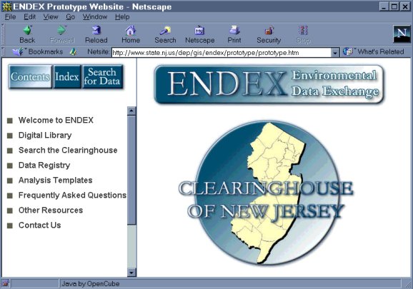
Figure 1: ENDEX Home Page Screenshot.
ENDEX is designed to be as user-friendly as possible, making environmental data and GIS more accessible to the public and casual users. ENDEX brings GIS to the desktop without requiring any special software or hardware, just a Java-enabled web browser and access to the internet. The "occasional user" will be presented with an easy-to-use interface that guides the user through simple mapping, analysis and data retrieval. An "analysis user" will be able to take the GIS capabilities even further for a more in-depth analysis and results display. The "professional user" will be able to perform the most complex GIS tasks.
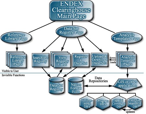
Behind the scenes, ENDEX components reside on distributed servers. Valuable functions are dispersed among servers at the NJDEP, the NJ Office of Information Technology, and Rutgers University. The unified interface developed for ENDEX clearly joins all of the component parts. This allows users to seamlessly access data from several different servers through the same user interface. The ENDEX interface also conceals data repositories that house datasets and databases, allowing users to retrieve or otherwise use the underlying data without dealing with complicated native interfaces (see Figure 2, below).
Three key ENDEX components are the digital library, the data set registry, and the analysis templates (see Figure 2, above). The New Jersey Environmental Digital Library includes documents, such as DEP studies, reports, and master's theses; multimedia components; and historic maps. The data set registry (for spatial and non-spatial data) allows individuals and organizations to self-register data sets. The analysis templates encompass GIS mapping and analysis tools, addressing information retrieval needs. Search functions enable users to locate and retrieve data registered in any of the three components.
Digital libraries are organized collections of digital information. They combine the structuring, gathering and cataloging of information, which libraries and archives have always done, with the digital representation that computers have made possible. Digital information can be accessed rapidly from remote sites, retained for preservation purposes, stored compactly, and searched very quickly. The contents of a Digital Library can be created by converting documents to digital form and from the incorporation of items already in electronic form. Contents are not limited to document surrogates; digital libraries may include data, multi-media, and other digital artifacts that cannot be represented in print, as well as links to related collections residing at dispersed, remote web sites.
The New Jersey Environmental Digital Library is being created through the partnership of the Rutgers University Scholarly Communication Center and the NJDEP. The Digital Library contents will be developed by the Alexander Library in close consultation with NJDEP staff, and collection development will reflect agency priorities, e.g. watershed management issues. The Digital Library will provide, whenever possible, full-text access to environmental reports, data, and multimedia emanating from state and local governments, non-profit organizations, research institutes, academic departments, and environmental consulting agencies.
The Data Set Registry enables contributors to self-register data sets via online and offline methods, depending upon the type of data and the user's preferences. GIS Data can be registered either using a web-based metadata entry form or using NJMetaLite, a metadata entry tool that runs on desktop PCs. Digital Library Data can be registered using web-based metadata entry forms for reports, inventories, theses, dissertations, data sets, and organizational information. Submitted metadata is checked for proper content and format before it becomes available to ENDEX users.
NJMetaLite and Metadata Training
The key to open information access and data-sharing on the internet are FGDC compliant metadata files that contain up-to-date, detailed information. Metadata, or "data about data," provide documentation of data sets, describing content, quality, condition, and other characteristics. To efficiently document data requires research, compilation and organization. The processes and procedures necessary to create FGDC compliant metadata has not been an easy task in the past. The NJDEP developed a metadata tool to ease the difficulties associated with understanding and creating FGDC compliant metadata.
NJMetaLite is a metadata entry system designed to meet the needs of New Jersey's GIS community. This software application, which runs on Windows 95/98 and Windows NT (Service Pack 5 or above), is a modification of MetaLite, a metadata tool developed by the United States Geological Survey and the United Nations Environmental Programme. Modifications by NJDEP incorporate fields and features relevant to GIS work being done in New Jersey (see Appendix). NJMetaLite's metadata entry forms are organized in a card catalog type format with tabs for each of the main topics (see Figure 3, below).
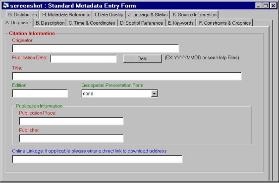
Figure 3: NJMetaLite Screenshot.
Some screens have pull-down menus and pick lists to aid in the data entry. The tool populates many required fields automatically with default values that are common to New Jersey (such as the spatial reference information for New Jersey State Plane Coordinates NAD27 and NAD83). Information can also be copied from .txt and .doc files and pasted into the NJMetaLite fields. Metadata files can easily be saved, closed, and worked on at a later time. NJMetaLite also contains a help file which provides users with the official FGDC definitions for fields, common language definitions, examples, and answers to frequently asked questions (FAQs).
In addition to NJMetaLite and online metadata help through ENDEX, a collaboration of GIS users in New Jersey developed a training program to teach the importance and procedures of writing metadata. The NJ Metadata Training Workshop is geared towards technically oriented GIS users needing to document
geospatial data. The day long workshop introduces basic metadata and clearinghouse concepts and gives attendees the information they need to create FGDC compliant metadata. During the workshop, participants gain hands on experience creating metadata using NJMetaLite. Participants are encouraged to begin working on their own metadata files during the workshop. These workshops are offered as part of the FGDC "Don't Duck Metadata" Program and are funded in part by a FGDC Grant.The New Jersey Metadata Workshop curriculum and NJMetaLite application are both available for download from the NJDEP-GIS web site, and is also distributed on CD-ROM at metadata training workshops. To download this information, go to http://www.state.nj.us/dep/gis/endex.html and follow the link for either "NJMetaLite: New Jersey's Metadata Tool" to get the tool or the link for "Metadata Training Workshops" to get the curriculum and other training information. NJMetaLite and the Metadata Workshops exemplify the NJDEP GIS commitment to helping GIS users in New Jersey create FGDC-compliant metadata for the New Jersey Geospatial Data Clearinghouse.
Analysis templates encompass GIS mapping and analysis tools, addressing information retrieval needs. Templates extract data from fields in one or more databases, perform a pre-defined analysis or manipulation, and deliver results through the user's web browser. The user defines the basic terms of data retrieval, analysis is performed though server-side applications, and results are displayed to the user as maps, photographs, tables, individual statistics, etc. depending upon the template selected. Eventually, templates could be devised to retrieve specified field-based data and package it as a custom data set to download and then manipulate with external tools (i.e. models).
The New Jersey GIS Community Profile
ENDEX's first fully functioning analysis template is The New Jersey GIS Community Profile, which utilizes data gathered by the National States Geographic Information Council (NSGIC) and the Federal Geographic Data Committee (FGDC) during a recently concluded survey of over 5000 data users throughout the United States. This survey provides a snapshot of data being produced and used in state, regional, and local organizations that could contribute to the framework of locally produced and maintained data themes available. The New Jersey results have been compiled into an ArcView Interactive Map Server (IMS) application running on a Windows NT server. The IMS application serves GIS data to a user's web browser. It includes information about the statewide GIS community and framework data: geodetic control, orthoimagery, elevation, transportation, hydrography, governmental units, and cadastral information.
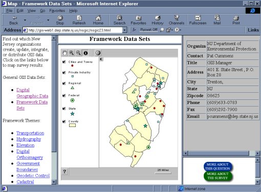
Figure 4: Screenshot of The New Jersey GIS Community Profile.
The Profile identifies companies, agencies, and organizations creating, updating, integrating, or distributing framework data. It also shows areas where data or data production is lacking. Users can select the map they wish to view, zoom in to an area of interest, and use the identify button to find out more about the organizations displayed on the map (see Figure 4, above). Users can also click on the "MORE ABOUT THIS QUESTION" button to see the percentage of yes/no responses to that question (see Figure 5, below) or click the "MORE ABOUT THE SURVEY" button to download survey questions, answers, and charts or connect to the FGDC website about the national survey.
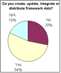
Figure 5: Chart of responses to survey question.
Watershed Tour
Another Analysis Template under development for ENDEX is a Watershed Tour, also an ArcView IMS application. Data including municipal boundaries, water quality monitoring points, Pinelands boundaries, and streams and water bodies will be presented for Watershed Management Areas (see Figure 6, below). Monitoring points are linked to sampling data, and certain points link to a panoramic view or to digital photographs of the sampling site (see Figure 7, below). Within the NJDEP, the Bureau of Geographic Information and Analysis is working with staff from Water Monitoring and Management to add other features to the application.
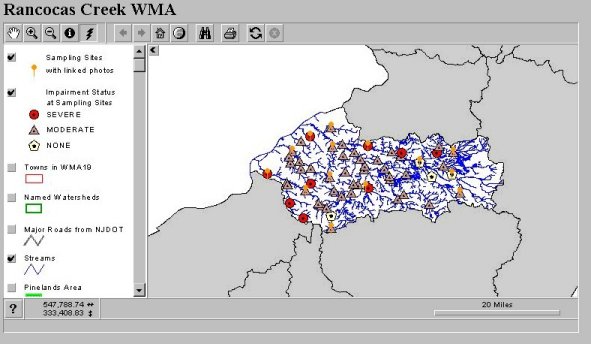
Figure 6: Watershed Tour Screenshot.
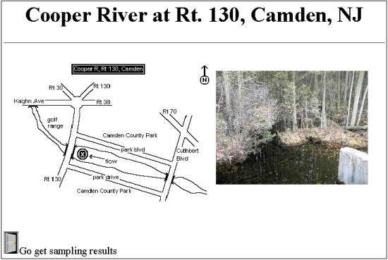
Figure 7: Watershed Tour Monitoring Point Information.
The analysis template pages are intended to provide connectivity to rich environmental databases housed by the NJDEP which contain regulatory, enforcement, and permitting data (stored in the New Jersey Environmental Management System, or NJEMS) as well as ambient environmental quality data. This will allow regulatory staff to easily access GIS tools via the intranet and ultimately allow the public to connect to an appropriate subset of NJDEP database information on the internet, using simplified GIS tools to explore that information and obtain answers to common questions.
ENDEX truly provides a statewide resource for the users of environmental information. Potential clients include not only NJDEP staff, but also personnel in other state government departments, as well as county and municipal government employees. The system will serve users beyond the public sector, including the regulated community, stakeholders, local watershed associations, environmental commissions, and concerned citizens. Significant potential exits for educational, academic, and research-oriented use as well, fostered through collaborations with the Rutgers University Scholarly Communication Center and the Bloustein School of Planning and Public Policy.
The goal of ENDEX is to demonstrate to the public and to other environmental agencies how open information access and data sharing on the internet can improve effectiveness and accelerate the transition to community-based environmental management. ENDEX will maximize geographic information technologies to help solve real world problems. The environmental community will be able to utilize metadata to obtain updated and detailed information to incorporate into their GIS. In turn, this will allow them to effectively and efficiently deal with and solve real-life environmental problems by having access to well-documented data in a more timely and cost effective manor.
In order to produce such a comprehensive data exchange, the NJDEP has officially partnered with the New Jersey Office of Information Technology - Office of GIS, Rutgers University Bloustein School of Planning and Public Policy, and Rutgers University Scholarly Communication Center. Specific individuals at these and other organizations who deserve create for developing ENDEX include:
John Bocchino, ENDEX
NJ Department of Environmental Protection
Paul Caris, ENDEX
NJ Department of Environmental Protection
Marla R. Chassels, ENDEX
NJ Department of Environmental Protection
Tim Huizing, ENDEX
NJ Department of Environmental Protection
Karen Mitchell, BGIA
NJ Department of Environmental Protection
Jackie Arnold, Office of GIS
Office of Information Technology
Lyna Wiggins
Chair and Graduate Director
Rutgers University
Department of Urban Planning
and Policy Development
Linda Langschied
Scholarly Communications Center
Rutgers University
Alexander Library
Jennifer Gaines
USGS/ Biological Resources Division
Technical Information Specialist
Nina Savar
Northeastern Illinois
Planning Commission
GIS Manager
Numerous other partners within and outside of the NJDEP have contributed to the advancement of specific features of ENDEX. Thank you to everyone who has contributed to the Environmental Data Exchange.
Fields Included in NJMetaLite 1.0
| Section 1: Identification Information | |
| 1.1 | Citation |
| 1.2 | Description |
| 1.2.1 | Abstract |
| 1.2.2 | Purpose |
| 1.2.3 | Supplemental Information |
| 1.3 | Time Period of Content |
| 1.3.1 | Currentness Reference |
| 1.4 | Status |
| 1.4.1 | Progress |
| 1.4.2 | Maintenance & Update Frequency |
| 1.5 | Spatial Domain |
| 1.5.1 | Bounding Coordinates |
| 1.5.1.1 | West Bounding Coordinate |
| 1.5.1.2 | East Bounding Coordinate |
| 1.5.1.3 | North Bounding Coordinate |
| 1.5.1.4 | South Bounding Coordinate |
| 1.6 | Keywords |
| 1.6.1 | Theme |
| 1.6.1.1 | Theme Keyword Thesaurus |
| 1.6.1.2 | Theme Keywords |
| 1.6.2 | Place |
| 1.6.2.1 | Place Keyword Thesaurus |
| 1.6.2.2 | Place Keywords |
| 1.6.4 | Temporal |
| 1.6.4.1 | Temporal Keyword Thesaurus |
| 1.6.4.2 | Temporal Keywords |
| 1.7 | Access Constraints |
| 1.8 | Use Constraints |
| 1.9 | Point of Contact |
| 1.10 | Browse Graphic |
| 1.10.1 | Browse Graphic File Name |
| 1.10.2 | Browse Graphic File Description |
| 1.10.3 | Browse Graphic File Type |
| 1.13 | Native Data Set Environment |
| Section 2: Data Quality Information | |
| 2.1.1 | Attribute Accuracy Report |
| 2.2 | Logical Consistency Report |
| 2.3 | Completeness Report |
| 2.4.1.1 | Horizontal Positional Accuracy Report |
| 2.4.2.1 | Vertical Positional Accuracy Report |
| 2.5.1 | Source Information |
| 2.5.1.2 | Source Scale Denominator |
| 2.5.1.3 | Type of Source Media |
| 2.5.1.4 | Source Time Period of Content |
| 2.5.1.4.1 | Source Currentness Reference |
| 2.5.1.5 | Source Citation Abbreviation |
| 2.5.1.6 | Source Contribution |
| 2.5.2 | Process Step |
| 2.5.2.1 | Process Description |
| 2.5.2.3 | Process Date |
| Section 3: Spatial Data Organization Information | |
| 3.2 | Direct Spatial Reference Method |
| 3.3 | Point and Vector Object Information |
| 3.3.1.1 | SDTS Point & Vector Object Type |
| 3.3.1.2 | Point and Vector Object Count |
| 3.4 | Raster Object Information |
| 3.4.1 | Raster Object Type |
| 3.4.2 | Row Count |
| 3.4.3 | Column Count |
| 3.4.4 | Vertical Count |
| Section 4: Spatial Reference Information | |
| 4.1 | Horizontal Coordinate System Type |
| 4.1.1 | Geographic |
| 4.1.1.1 | Latitude Resolution |
| 4.1.1.2 | Longitude Resolution |
| 4.1.1.3 | Geographic Coordinate Units |
| 4.1.2 | Planar |
| 4.1.2.1 | Map Projection |
| 4.1.2.1.1 | Map Projection Name |
| 4.1.2.2 | Grid Coordinate System |
| 4.1.2.2.2 | UTM |
| 4.1.2.2.4 | SPCS |
| 4.1.2.4 | Planar Coordinate Information |
| 4.1.2.4.2 | Coordinate Representation |
| 4.1.2.4.2.1 | Abscissa Resolution |
| 4.1.2.4.2.2 | Ordinate Resolution |
| 4.1.2.4.4 | Planar Distance Units |
| 4.1.3 | Local |
| 4.1.3.1 | Local Description |
| 4.1.3.2 | Local Georeference |
| 4.1.4 | Geodetic Model |
| 4.1.4.1 | Horizontal Datum |
| 4.1.4.2 | Ellipsoid Name |
| 4.1.4.3 | Semi-major Axis |
| Section 5: Entity and Attribute Information | |
| 5.1 | Detailed Description |
| 5.1.2 | Attribute |
| 5.1.2.1 | Attribute Label |
| 5.1.2.2 | Attribute Definition |
| Section 6: Distribution Information | |
| 6.1 | Distributor |
| 6.2 | Resource Description |
| 6.3 | Distribution Liability |
| 6.4.2.1 | Digital Transfer Information |
| 6.4.2.1.1 | Digital Format Name |
| 6.4.2.1.2 | Format Version Number |
| 6.4.2.1.6 | File Decompression Technique |
| 6.4.2.1.7 | Transfer Size |
| 6.4.2.2.1.1.1.1 | Network Resource Name (Distribution Site) |
| 6.4.2.2.2.1 | Offline Media |
| 6.4.2.2.2.3 | Recording Format |
| 6.4.3 | Fees |
| 6.4.4 | Ordering Instructions |
| Section 7: Metadata Reference Information | |
| 7.1 | Metadata Date |
| 7.4 | Metadata Contact |
| 7.5 | Metadata Standard Name |
| 7.6 | Metadata Standard Version |
| Section 8: Citation Information | |
| 8.1 | Originator |
| 8.2 | Publication Date |
| 8.3 | Title |
| 8.5 | Edition |
| 8.6 | Geospatial Data Presentation Form |
| 8.8 | Publication Information |
| 8.8.1 | Publication Place |
| 8.8.2 | Publisher |
| 8.9 | Other Citation Details |
| 8.10 | Online Linkage |
| Section 9: Time Period Information | |
| 9.3.1 | Beginning Date |
| 9.3.3 | Ending Date |
| Section 10: Contact Information | |
| 10.1.1 | Contact Person |
| 10.1.2 | Contact Organization |
| 10.4 | Contact Address |
| 10.4.1 | Address Type |
| 10.4.2 | Address |
| 10.4.3 | City |
| 10.4.4 | State or Province |
| 10.4.5 | Postal Code |
| 10.4.6 | Country |
| 10.5 | Contact Voice Telephone |
| 10.7 | Contact Facsimile Telephone |
| 10.8 | Contact Electronic Mail Address |
Features of NJMetaLite 1.0
Future Changes in NJMetaLite
The Environmental Data Exchange (ENDEX)
http://www.state.nj.us/dep/gis/endex.html
Federal Geographic Data Committee (FGDC)
http://www.fgdc.gov
National States Geographic Information Council (NSGIC)
http://www.nsgic.org/
New Jersey Department of Environmental Protection (NJDEP)
http://www.state.nj.us/dep
NJDEP GIS
http://www.state.nj.us/dep/gis
NJDEP Strategic Plan - "Open and Effective Government"
http://www.state.nj.us/dep/commissioner/stratplan/index.html
Rutgers University Bloustein School of Planning and Public Policy
http://policy.rutgers.edu/bloustein/
Rutgers University Scholarly Communication Center
http://scc01.rutgers.edu/scchome
United Nations Environment Programme (UNEP)
http://www.unep.org
United States Geological Survey (USGS)
http://www.usgs.gov