Petersburg National Battlefield acquired color infrared aerial photographs of the park. This project will produce a digital orthorectified mosaic from the photography. Detailed vegetation polygons will be classified using The Nature Conservancy's National Vegetation Classification System. Typically zoom transfer scopes are used to develop this type of vegetation database. However, we are scanning and rectifying the aerial photography scanned at 600 dpi and rectified in ERDAS IMAGINE using DEMs and DOQQs. The vegetation polygons are then created directly on the computer screen in ArcMap.
Petersburg National Battlefield acquired aerial photos from March 1992. The photos are color infrared at a scale of 1/3000. This project concentrated on photos of the Petersburg Main Unit; an area covering 1,440 acres with 75 aerial photos. Since a high level of classification should be easily attainable with such large-scale photography, it was decided that the project would follow the guidelines put forth by the USGS and the NPS Vegetation Mapping Program (these guidelines can be found at http://biology.usgs.gov/npsveg/). Meeting these guidelines will allow incorporation of Petersburg National Battlefield into the USGS-NPS plan as a park in progress.
These guidelines are very inclusive and very specific. They include references for accuracy standards, accuracy assessment, vegetation classification, and overall map accuracy. The Nature Conservancy’s National Vegetation Classification is the classification system chosen by the USGS-NPS. It is a hierarchical system that allows for classification to different levels from very broad at class and subclass levels down to exact groups of species at the association level. The developed areas were classified using a system developed by Mitchell 1995.
Based on the scale of the photos, the Formation level was chosen as the target classification level with a minimum mapping unit of 0.5 acres. The guidelines call for 80% overall class accuracy and a minimum mapping unit of at least 0.5 hectare. The guidelines also specify that the maps produced should meet National Map Accuracy Standards. The goal of this project was to produce a final orthorectified map showing vegetation that meets all the above standards using a fully digital methodology that bypassed using a zoom transfer scope.
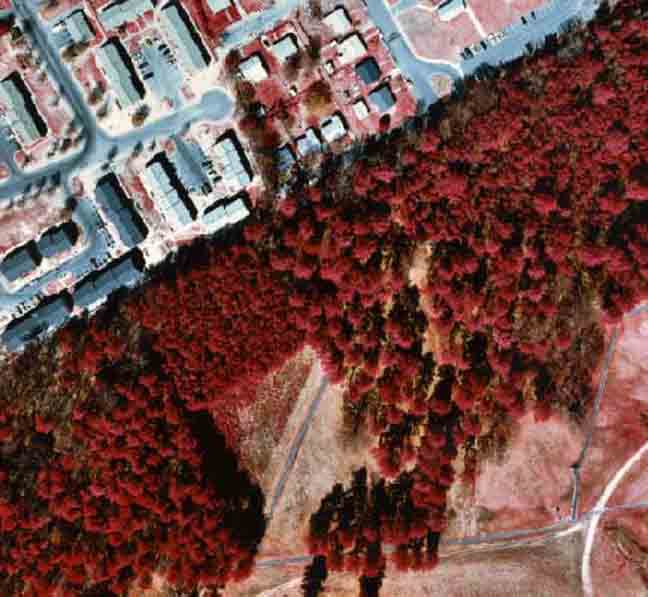
The first step was to scan all the color photographs into TIFF images at 600 dpi. After comparing multiple resolutions, 600 dpi was determined to provide a good balance between image quality and file size. The TIFF images were then imported into Imagine, which was used for the rectification and mosaicking process. A black and white DOQQ was used to acquire reference points and a resampled DEM was used for elevation values. Each photo was orthorectified separately and then mosaicked. The resulting color infrared mosaic was 1.6 gigabytes in size. This file was then compressed to about 50 megabytes using Mr. Sid with very little data loss (Figure 1).
Once the rectified image was complete, ArcMap was used to delineate the vegetation polygons. The polygons were drawn onscreen using a stereoscope and stereo pairs as reference.
Following the guidelines outlined by the USGS/NPS program, an accuracy assessment was performed for both thematic and positional accuracy. To evaluate thematic accuracy, 158 of 228 polygons were sampled in the field. A Trimble Pro XR GPS unit with real time correction was used to reach the sample points in the field. Once the correct location was reached for each polygon, the accuracy form for the USGS-NPS Vegetation Mapping Program was completed. Data collected at the site included elevation, canopy closure, topographic description, aspect, major species present by strata, as well as vegetation formation.
Positional accuracy was determined by choosing readily identifiable points on the rectified image. The points were then located in the field and a reading was taken for three minutes with a Trimble Pro XR GPS unit with real time correction. These points were then corrected using Pathfinder software.
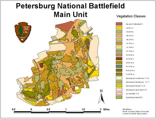
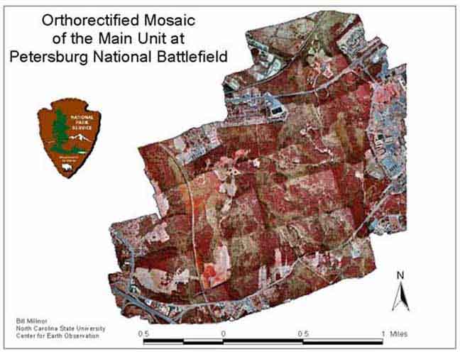
A map produced in ArcView shows the vegetation classification for the Main Unit of Petersburg National Battlefield (Figure 2). The final Mr Sid orthorectified image is shown in Figure 3.
An overall thematic accuracy of 82.28% was obtained with 20 different vegetation types found within the Main Unit. Positional accuracy was found to have a RMSE of 1.88 meters in the x-direction and 2.85 meters in the y-direction. This places the map in the Class 2 range for map accuracy according to the ASPRS Accuracy Standard for large-scale maps. (ASPRS, 1989)
The goal of this project was to meet National Map Accuracy Standards while satisfying the USGS-NPS Vegetation Mapping Project guidelines using a fully digital methodology. These goals were met and efforts to improve the accuracy and ease of use of this digital methodology are currently underway. Further study is needed to compare the accuracy of delineating polygons onscreen in two dimensions versus delineating polygons onscreen while viewing in three dimensions using programs such as DVP or Stereo Analyst.
Mitchell, J.T. 1995. Applications of Geographic Information Systems to Urban Forestry: Analyzing the Forest Dynamics of Cary, North Carolina. Master's Thesis. Raleigh, North Carolina: North Carolina State University.
ASPRS, 1989. ASPRS Accuracy Standards for Large-Scale Maps. ASPRS 1989 Annual Report. 1068-1070.