ABSTRACT: The Regional Geographic Information System (REGIS) is one of the largest municipal consortium GIS programs with 20 local government participants from Western Michigan. The goal of the program is to develop and deploy a common GIS database and suite of applications to serve the needs of all participant members. This task has been challenging in many respects, particularly in regard to the overall design of the system. REGIS consortium members are geographically dispersed across the region, making the logistics of implementing enterprise-wide GIS a challenge. The issue is confused even more considering that each of the participant organizations has data maintenance responsibilities. This paper will discuss an approach for deploying ArcFM-based editing capabilities, along with ArcView and Web-based applications, across the enterprise. The issues involved with implementing a core "centralized" SDE database will also be discussed.
Approximately twenty local government units and municipal agencies in Western Michigan have been working over the last three years to develop shared geographic information systems (GIS) applications and databases. Development of this system has enabled both participants and their constituents to foster intelligent and productive decision-making. As part of this initiative, consortium members have adopted a GIS strategic plan with assistance from Englewood, Colorado-based consultants Convergent Group.
In 1997, the REGIS Agency was established by the Grand Valley Metropolitan Council (GVMC) to develop a common system on behalf of project participants. The participants include Alpine Township, Byron Township, Cascade Charter Township, Cedar Springs, City of East Grand Rapids, City of Grand Rapids, City of Grandville, City of Hudsonville, City of Kentwood, City of Rockford, City of Walker, City of Wyoming , Gaines Charter Township, Grand Rapids Area Transit Authority, Grand Rapids Township, GVMC, Kent County, Kent County Road Commission, Plainfield Township, and the Village of Sparta. Later that year, the consortium initiated a pilot project to test all system assumptions prior to full implementation of the REGIS Strategic Plan.
Efforts during the pilot focused on the development of a common GIS database that served to replace thousands of aging hardcopy maps and records. In addition, an integrated suite of applications was also developed. Considerations were taken into account for data modeling, data scrub, conversion, addressing, system design, applications development, and deployment. By using various planning, cadastral, facilities, transportation, and utility data sources, REGIS was able to validate project assumptions prior to full implementation.
Following the successful completion of the Pilot project, REGIS moved forward with Phase II of the strategic plan. Essentially, the scope of Phase II was to move forward with full data conversion, which includes not only Kent County but also portions of neighboring Ottawa County. This entails digital conversion of "100 scale" (1:1200) property maps, public utility infrastructure, and landuse and zoning maps, all referenced to 1 / 2 foot resolution digital orthophotography in urban areas, and 1 foot resolution orthos in rural areas. REGIS has entered into contract with Analytical Surveys, Inc. for the bulk of data conversion.
Phase II activity also includes an enterprise approach to applications delivery, data dissemination, and system access. In addition, several GIS applications are in the process of being developed and rolled-out to end users. These include data maintenance tools, casual user applications, and more advanced spatial analysis tools.
REGIS has adopted an enterprise approach to application development. This entails developing applications that are useful and have a broad level of appeal to project participants. With assistance from Convergent Group staff, REGIS is in the process of defining and developing several end-user applications. These include:
Typical milestones during the application development process include:
The coordination of application development efforts with 20 participants has presented quite a challenge to the REGIS staff. This has led to large-scale cooperation in the areas of symbology standards, classification systems, training, and data conversion initiatives. It is also important to note that applications are developed using industry standard tools such as Rational's Distributed Defect Tracking System (DDTS) and Microsoft Visual Source Safe for source code control.
In early 1999, Convergent Group organized and conducted a systems analysis workshop. The goal of this workshop was to review and technically assess the overall-computing infrastructure for each of the REGIS participants, as well as determine a strategy for deploying applications and data to users within the enterprise. After reviewing participant needs, an approach was presented to REGIS participants. This approach included:
More specifically, the proposed centralized architecture approach included the following recommendations:
The proposed centralized solution allows REGIS participants and end-users to:
In order to support all end user needs, a unique solution was required. This included the planning, design, configuration, and deployment of the following components:
After careful review, a Windows NT remote access solution was deemed the most optimal and cost effective approach. Specifically Windows NT, Terminal Server Edition (NTTS) was selected as the means by which clients access server-based applications and data.
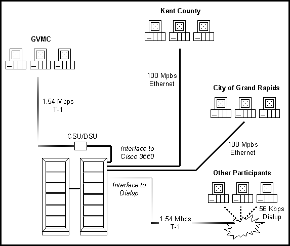
From an operational standpoint, remote users would access GIS applications through NTTS client software via WAN connectivity (Figure 1). This essentially allows end-user workstations to be "thin" clients, as all applications, data, and processing are performed directly on the server end. All NTTS network traffic is handled by the native Microsoft Remote Desktop Protocol (RDP).
Figure 1. REGIS WAN Architecture
While hardware requirements on the server end increase (e.g., RAM, disk space, multiprocessors, etc), hardware and software requirements on the client end decrease (e.g., less RAM and disk space required to support thin client, removal of GIS dependency on NT-based client, etc). It is for this reason that additional server-based equipment was required to support this architectural approach.
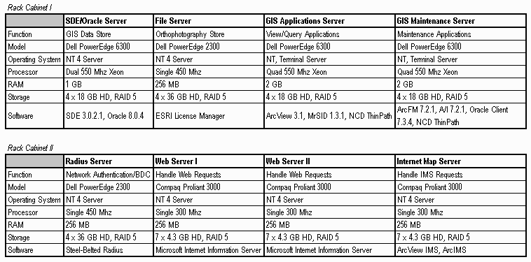
During the planning stages of the system architecture design, server equipment was logically separated based on its function. For example, all SDE data and associated Oracle tables are located on dedicated hardware built specifically to perform the role of an "RDBMS / SDE server". All orthophotography is located on a dedicated file server. In addition, two NTTS servers were allocated to support end users, depending on their role as Maintenance Applications Users (e.g., ArcFM), or View / Analyze / Query Applications Users. A detailed description of the server environment can be seen in Table 1.
Table 1. Server Specifications
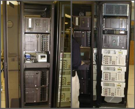
Over the course of several months, Convergent Group staff procured, installed, configured, tested, and deployed the centralized server environment at the City of Grand Rapids MIS building (Figure 2). This facility allows REGIS to take advantage of a state-of-the-art server-computing lab, which includes backup power support, fire / disaster protection, security, and climate control.
Figure 2. Completed Server Setup at Grand Rapids MIS
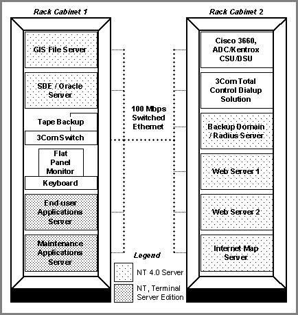
The centralized architecture solution is essentially a cluster of servers networked via 100 Mbps Switched Ethernet using a 3Com SuperStack 3300 10 / 100 Switch (Figure 3). WAN and dialup connectivity is managed through a dedicated Cisco 3660 Router, Kentrox CSU / DSU, and a 3Com Total Control Dialup Solution. When users are authenticated on the REGIS domain, they are granted system access. Users are limited to using only the types of applications they have been granted access to (e.g., Maintenance Applications Users vs. View / Analyze / Query Applications Users).
Figure 3. REGIS Server/LAN Architecture
As for end user applications, REGIS has selected ArcFM 7.2.1 as its data maintenance environment. This solution has been custom configured by Convergent Group to support editing of the landbase (parcels, subdivisions, street network, school districts, buildings), as well as all public utility data such as water, sewer, and electric. ArcFM allows users to perform data maintenance activities at the feature level on a seamless SDE database.
Currently, the bulk of end-users access the centralized database using the REGIS Data Browser application. This ArcView-based tool allows users to view, query, analyze, and create reports from the SDE data store. The application is strictly read-only, and has no data editing capabilities. Local printing and plotting capabilities are supported in the Map Production application, which is also based on ArcView. This application allows users to produce standard and ad-hoc map products, while taking advantage of Esri’s ArcPress technology.
Regarding system administration, Convergent Group staff is able to administer this environment remotely using native NTTS and pcAnywhere software. Terminal server sessions, user accounts, tape backups, and basic system maintenance can be conducted in this manner. There is little need to come in contact with the hardware environment other than to exchange tapes during scheduled backup times or in the case of hardware failure.
The largest hurdle REGIS faces is in the area of "technology transfer". From an end user standpoint, the deployment of new technology and applications requires substantial training. From the beginning, the REGIS Agency has accommodated end-users with applications training support. To date, hundreds of professional staff from the various participant organizations have received training on both the maintenance applications as well as the casual user applications.
Technology transfer of the system administration, database administration, and WAN is occurring in a phased approach over several months. Currently, System Administrators and Network Engineers at Convergent Group assist and provide technical support to REGIS staff in administering the system. It is important to note that the REGIS Agency has recently hired a System Administrator who will assume this role following required training.
In conclusion, REGIS is clearly on the fast track to establish a significant GIS presence in Midwest. The unprecedented cooperation of 20 municipal agencies has presented its challenges, while also setting an example of government at its best. Following completion of data conversion, as well as system maturation, user proficiency, and increased efficiency through process re-engineering, REGIS will surely evolve into a nationally recognized GIS program.
For up-to-date details on the program, please visit the REGIS website at:
http://www.gvmc-regis.org