
Figure 1
A Survey Planner and Status Tracking System prototype has been successfully implemented at the Naval Oceanographic Office. Using this proof-of-concept, scientists, engineers, and analysts in-house evaluated oceanographic survey status and the performance of survey systems in near-real-time from survey platforms deployed throughout the world. The prototype is implemented in two integral parts. The Survey Planner functions include custom ArcView extensions designed to create standardized Survey Plans using both menu driven "interview" techniques integrated with customized graphic tools. The Survey Tracking functions demonstrate a near-real-time ship location/status capability using Navy messages, an Oracle database, and SDE which provides data management, both for analysts using ArcView GIS and end-users using ArcExplorer. The prototype is now under development into a pilot program that will be demonstrated during future Joint Fleet Battle Exercises.
The Naval Oceanographic Office (NAVOCEANO), located at the John C. Stennis Space Center (SSC) in Mississippi, exercises technical control over a fleet of eight survey vessels and two survey aircraft, operational around the world. Bathymetric, hydrographic, oceanographic, geophysical, and various other types of data are collected in support of naval operations, both on and above the world’s oceans. NAVOCEANO survey teams are manned with the skills to provide the necessary knowledge to support the specific data collection efforts of each survey. The concept of a Survey Planning and Ship Tracking System (SPSTS) was developed to provide digital survey planning tools, near real-time survey support and to take full advantage of evolving technologies, better using highly skilled manpower by allowing many of the survey monitoring functions to become "cyber" functions.
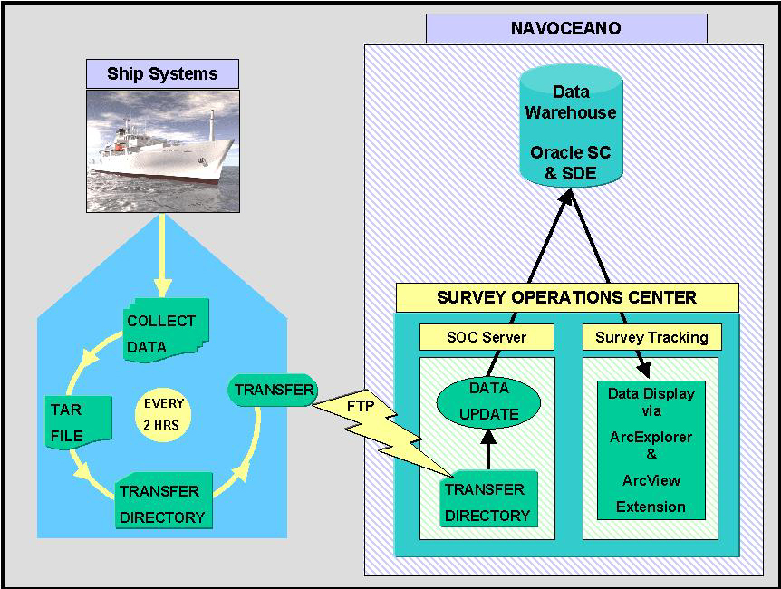
A prototype proof-of-concept for the SPSTS was designed and implemented by Planning Systems Inc. Working with the Naval Research Lab, Stennis Space Center, MS (NRLDET), a two-part design approach was taken. This design involved the customization of Esri ArcView software to develop both planning tools designed as functional objects (the Survey Planner) along with the ability to track and evaluate the progress of the survey when underway (the Ship Tracking System.) The SPSTS two-part design allows Survey Operation Center (SOC) planners to create ship surveys, while SOC analysts track survey progress on a near-real-time basis. SOC personnel optimize data collection efforts and avoid missed data collection opportunities by making efficient use of the time allotted for surveys and by alerting planners of potential sensor problems while the survey is in progress. As shown in the in Figure 1, the two SPSTS elements are designed to work in conjunction with the NAVOCEANO Data Warehouse, implemented in Oracle and spatially enabled using Esri Spatial Data Engine (SDE).
Individual ship surveys are created using the Survey Planner. This ArcView extension provides customized graphics tools integrated within an interview interface to create a completed survey plan. Once approved, the plan is formatted into the standard ISS60 data format for transmission to the operational survey platform. A standardized Concept of Operations (CONOPS) document also is produced as a database report. As shown in Figure 2, a dialog interface was designed to "interview" the planner to establish survey requirements. In this model, the planner is prompted for specific information pertaining to the type of survey, survey platform and other selections. The planner is alerted if any information entered deviates from the accepted standards. For example, database information about the types of sensors aboard the selected survey platform, linked to the dialog interface from the Data Warehouse, guides the planner through defining the use of the sensors for the particular survey. Prompts such as these act as a guide through the planning process, ensuring that accepted survey standards are followed. The knowledge base for the guide functions of the Survey Planner has been derived from discussions with NAVOCEANO experts and from standards manuals for some types of surveys such as IHO standards for hydrographic surveys. General geo-spatial tools were customized to fit the needs of the different survey types. These tools were designed as functional objects to allow the planner to draw the various features associated with the survey, including survey tracks, stations, and areas. Other tools have been customized to allow the planner to create and manipulate special survey features, such as multiple tracks at specified angles to the shoreline and the ability to add multiple stations to these tracks at specified intervals. One of the key Survey Planner functions provides the capability to calculate the time for each survey, enabling a mechanism for comparison to the allotted time allowable to the survey platform for individual surveys. Using this function, planners can add or reduce survey operations to meet the time constraints.

As the SPSTS moves from a prototype to a pilot project the development of the Survey Planner extension will continue incrementally, with the goal of developing expert systems within ArcView to facilitate planning several different types of surveys with customized graphics tools. The tools are designed as functional objects to "plug and play" wherever overlapping design elements between the various types of surveys make this practical. To create the background for the prototype, pertinent data sets were loaded to support survey planning. These included historical data from the NAVOCEANO Data Warehouse such as bathymetry and water column data, requirements data from the NAVOCEANO Requirements Database, Digital Nautical Chart (DNC) navigational aids and hazards to navigation and data from other sources such as the political, territorial and economic zone boundaries for the area of interest. A simple example of a survey plan is shown in Figure 3.

The second element of the SPSTS, the ArcView Ship Tracking extension, was developed to allow SOC analysts to track the location of survey platforms and to evaluate the status of on-going data collection efforts. This function clarifies the progress of individual surveys and has the potential to optimize data collection and data quality assurance by displaying near-real-time updates of ship status information. As shown in Figure 1, a C program was written to recognize each newly transmitted packet in a timely manner, to parse the packet and distribute the information for analysis into the NAVOCEANO Data Warehouse. When launched, the Ship Tracking extension connects to the NAVOCEANO Data Warehouse, displaying a view of the world that shows the updated locations of the survey platforms. The final version of the SPSTS will track and display all survey data through this near-real-time update system, while the ArcExplorer browser will display a subset of the same information. For prototype development and testing of the Ship Tracking extension, the NAVOCEANO LAN was simulated on the PSI GIS LAN, where Esri products including the Spatial Database Engine (SDE), ArcView, ArcExplorer and the ArcIMS beta3 were installed. A subset of the NAVOCEANO Data Warehouse was loaded into the PSI Oracle instantiation, along with some customization for the addition of SPSTS tables. Communications from a survey ship were then simulated using Navy message format files transmitted via Email, containing location and status information from five ships and one aircraft. NAVOCEANO analysts using the SDE ArcView client evaluated the survey progress as compared to the survey plan, and evaluated the Navy message text information for other status information. NAVOCEANO management in various locations throughout SSC viewed the progress of the survey platforms with the ArcExplorer browser. ArcIMS beta3 (html) was used to browse the data in-house. As the pilot project advances toward demonstration during the upcoming exercises, adaptations to the simulated scenario have been put into place. As shown in Figure 3, once the survey is underway ship reports along with selected subsets of data will be sent to NAVOCEANO on a periodic basis. These near-real-time survey updates will be transferred between a shipboard LINUX system and an in-house WindowsNT system using a standard TCP/IP protocol. The conversion process continues to be based on a continuously running C program, which reads the incoming files from the ship and updates database tables housed within the Data Warehouse. Incoming files will now contain screen shots of data (GIF files), actual data sets (ASCII files) and standard Navy message files. Using SDE to manage the data layer updates, SOC analysts will evaluate sensor data updates with the ArcView Ship Tracking System extension while SOC planners and management personnel view the ship location/survey status with ArcExplorer.
The SPSTS proof-of-concept demonstrated the success of NAVOCEANO’s Survey Operation Center design. As the proof-of-concept is transitioned to a pilot project, additional survey types will be customized as ArcView extensions, and additional data will be added to further support survey planning. When fully operational, data collection surveys will be designed and implemented by the Survey Plans Division of NAVOCEANO using SPSTS to standardize the highly technical survey requirements. As forward strides continue to be realized in communications bandwidths, additional data will be returned to NAVOCEANO via these channels. Ultimately SPSTS will enable NAVOCEANO scientists, engineers and analysts ashore to evaluate the status and performance of shipboard systems, as well as view the actual data collected from ships deployed around the world.