
The Development of Socioeconomic Data From the Ground Up
Craig A. Batstone
ABSTRACT
The process of developing socioeconomic data projections for Traffic Modeling, has traditionally been accomplished through a top-down methodology, where control totals are created for a county and then disaggregated down to individual Traffic Analysis Zones. METROPLAN ORLANDO and Canin Associates are developing an application, built on Arc/Info’s ODE, that will analyze existing and future land uses at the parcel level to calculate socioeconomic data projections. The application has several modules that perform tasks such as: Data Update, Analyze Existing Development, Identify Developable Land, Developable Land Suitability Ranking, Projected Growth Pattern, and Socioeconomic Data Calculations.
INTRODUCTION
Canin Associates (CA) and Metroplan Orlando (the Metropolitan Planning Organization for Orlando, Florida, USA) are producing a growth allocation model for calculating socioeconomic data using Geographical Information Systems (GIS) software. Socioeconomic data is used by Metroplan Orlando staff to run traffic modeling applications. Socioeconomic data projections have traditionally been accomplished through a top-down methodology where forecasted control totals for a county are disaggregated down individual Traffic Analysis Zones. CA has utilized GIS to develop a "ground up" growth allocation model that takes an aggregated approach towards calculating socioeconomic data.
Transportation Planners have be developing and using traffic modeling applications for over 20 years. The refinement and calibration of traffic modeling applications has enabled Transportation Planners to model detailed traffic patterns and flows. While these models may be intricate they often lack some degree of accuracy. Accuracy issues are generally attributed to incomplete or inaccurate socioeconomic input data and not necessarily the specific modeling application. The socioeconomic data used for traffic modeling applications generally consists of information relating to where people live and where people work.
Socioeconomic data sets are developed for a base year and a forecast year. The base year data is used to model existing traffic conditions and the forecast year data is used to model the future performance of the existing road network. Transportation Planners use results from the models to identify where road improvements are needed.
Canin Associates collaborated with local government staff throughout METROPLAN ORLANDO’s three county territory to discuss and review growth patterns and planning issues within the respective jurisdictions. Emphasizing local government involvement was imperative in developing this process. The local governments must be involved as much as possible to assist in generating the data and to ensure confidence in the data and the results. Local government review and input will strengthen the consensus building process between Metroplan Orlando and all of the agencies involved.
Growth Allocation Models
The Orlando metropolitan area is one of the most dynamic growth areas in the United States and has roughly doubled in size over a 20- to 25-year period. Determining current and future traffic needs for the Orlando metropolitan area has been, and continues to be, a complex task involving multi-jurisdictional entities with independent and often uncoordinated growth management programs. The Florida Standard Urban Transportation Modeling Structure (FSUTMS) utilizes socioeconomic data to predict future transportation needs. Socioeconomic data, in turn, is derived from analysis of the land use market and development trends in the area as interpreted by planners, economists, realtors and other professionals.
The development of this data at the traffic analysis zone (TAZ) level projected into the future involves consideration of an extraordinary range of variables. Land use variables are particularly difficult to forecast and measure and demonstrated the vulnerability of the traditional modeling process. These variables include:
The future METROPLAN ORLANDO modeling process must be tailored to fit the unique Central Florida situation. The process must be based on key data and issues, which address real factors operating in the Orlando area. The overall process must utilize consensus management to determine planning standards, policy interpretations and highly informed judgements on the direction and form that development patterns will take. Traditional modeling practices do not meet these requirements.
GIS decision support for planning efforts must include: an inventory of available land, be sensitized to the subtleties of timing of development, and recognize the demands and trends of private development. The GIS model must also account for factors affecting physical feasibility such as utility availability, site conditions, and availability of transportation networks; and be sensitized to the regulatory policies utilized at the local, regional and state levels of government in the growth management process.
In the past, METROPLAN ORLANDO has experienced challenges utilizing the Disaggregated Residential Allocation Model and the Employment Allocation Model (DRAM/EMPAL) to project and allocate growth. This has been true for the following reasons:
Canin Associates’ Approach
The growth allocation model that is used for the Orlando Metropolitan area needs to be as dynamic and flexible as the growth pattern. CA has developed a GIS Growth Allocation Model which takes into account Central Florida variables and which meets the following criteria:
Process Flow
The following process flow diagram (See Figure 1) details the GIS data flow for this new approach to Growth Allocation Modeling. CA has named this GIS application ZGIS. ZGIS was chosen because the end result of the analysis is a full set of socioeconomic data. Socioeconomic data is commonly referred to as ZData. The ZData that is produced by ZGIS is used with the FSUTMS to assist in forecasting future transportation needs. In Figure 1, the yellow boxes represent where input data is needed, the gray boxes represent analysis functions and the blue boxes represent output from the analysis.
Figure 1: GIS Growth Allocation Model
Each of the boxes in the process flow diagram are further explained throughout the remainder of this paper.
Collect / Update GIS Data
The collection of GIS data in the study area required the coordination and cooperation of 27 local governments. The study area included Seminole County, Orange County, Osceola County and all of the local governments within each of the counties. (See Figure 2)

Figure 2: Study Area
Each of the local governments are currently using GIS software. Most of the local governments have been using GIS for several years while a few of them are still in the base data development stages. CA and METROPLAN ORLANDO assisted local governments whose data sets were incomplete. CA worked with local governments to either complete their data sets or find alternative data sets that would suffice
Data Collection Summary Table
The following table is a summary of the GIS data that was collected from each of the Counties. South Florida Water Management District (SFWMD) data was used to supplement some of the Osceola County data. GIS data that was collected from the cities within the counties will be incorporated into the County data structure where required. The following table (Table 1) is used to summarize the county level GIS data layers that have been collected.
Each of the GIS data layers in the table will be utilized to perform a specific analysis function in the development of the socioeconomic data. The Tax Parcels and the information associated with them provides the base for developing the socioeconomic data. There are over 700,000 parcels within the study area. Tax Parcels are used to create Existing Land Use layers for each county. The Existing Land Use data identifies the type of development that is currently associated with each parcel. The Lakes, Wetlands and the 100-Year Floodplain data is used to identify environmentally constrained areas that will limit future development. The remaining area is considered developable. The future land use layer is used to determine the type of development that can be expected in the developable areas. Road Network, Urban Service Area Boundary, Municipal and County boundaries, as well as Utility Sites and Lines layer are used as indicators for the future growth scenarios. Traffic Analysis Zones are used as the summary areas for the socioeconomic data, and Census data has aided in developing the baseline data. The combination of these GIS data layers forms the bases for the development of the socioeconomic data projections.
|
DATA REQUIRED |
ORANGE COUNTY |
SEMINOLE COUNTY |
OSCEOLA COUNTY |
|
Tax Parcel Information |
X |
X |
X |
|
Future Land Use |
X |
X |
CA |
|
Existing Land Use |
X |
X |
X |
|
Road Network |
X |
X |
X |
|
Urban Service Area Boundary |
X |
||
|
Lakes |
X |
X |
SFWMD |
|
Wetlands |
X |
X |
SFWMD |
|
100-Year Floodplain |
X |
X |
SFWMD |
|
Utility Sites / Lines |
X |
X |
|
|
Traffic Analysis Zones |
X |
X |
X |
|
County Boundary |
X |
X |
X |
|
Municipal Boundary |
X |
X |
X |
|
Census Data (1990) |
X |
X |
X |
|
SFWMD Data |
X |
X |
X |
Table 1 Data Collection Summary
Data Issues
Several data issues arose during the collection process, which required additional monitoring. These issues are; edge matching of data, conversion of data, and areas with incomplete data. These issues need to be monitored and addressed.
Edge Matching of Data
Edge matching of data is the matching or aligning of two different data sources. For Example, data that is obtained from the Cities must match the data that has been obtained from the County. If the two data sources do not match there will be overlapping data and data gaps. If this occurs, it will require some coordination between the City and the County to determine which data is accurate.
Edge matching between the Counties is another issue that needs to be addressed. Common boundary lines should be determined in order to store data efficiently. There is only a minimal disparity between the Counties. This disparity is most likely the result of the scale at which the source data was digitized and has not cause much of a problem.
Data Conversion
Data conversion can be time consuming and result in the loss of data if it is not done correctly. Most of the data conversion has been automated and will not affect the quality of the data at all. The conversion of data from third party software is of some concern. Third party software, in this case, is software that has not been created by or in conjunction with Esri. AutoCAD, MapInfo and Genasys are examples of third party GIS software. The data must be exported out of the original software in a usable format and also imported into Arc/Info or ArcView correctly. This process can be time consuming depending on the size and format of these files. CA has converted various data files into coverages and/or shapefiles. Any data that was converted from a format other than an Esri format was returned to the local government where the data originated. Most the local governments are currently making use of Esri format data that was returned to them.
Additional Data to be Added
Incomplete data can result in incomplete or skewed results depending on how the issue is handled. Incomplete data has been the exception and not the norm during the course of this work. Local governments that had incomplete data sets have worked very hard to complete them.
Update Process
The process of keeping the GIS data and socioeconomic projection data up to date requires the cooperation of all of the local governments involved. There are seven main steps in the process:
The ability of the local governments to keep data up to date is the most important step in the process. Updated data must be available for METROPLAN ORLANDO to perform an annual update to the socioeconomic projection data. The established transmittal date of January 31st should enable METROPLAN ORLANDO to receive a data set for the previous year. For example, if the data were received during January 1999, the data set would be for the 1998 base data update.
The coordination between CA, Metroplan Orlando and all of the local governments has aided in the development of this new approach to GIS growth allocation modeling for the Orlando Metropolitan area.
Identify Developable LAND
The "Developable Land Analysis" is a core process in forecasting the future socioeconomic data. The results of this analysis depend greatly on the accuracy of the input data sources. The "Developable Land Analysis" is undertaken by extracting land from the GIS data set. Land that is developed or committed is removed by querying the tax parcel database and the committed land use layers. This analysis identifies undeveloped land. (See Figure 3)
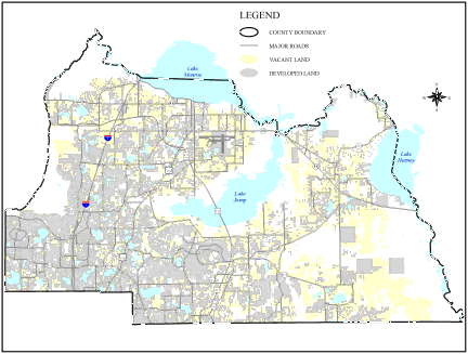
Figure 3: Built Parcels
Environmental constraints such as wetlands, lakes, and the 100-year floodplain are then extracted from the undeveloped land to create a developable land layer. Publicly owned land is also identified because, although it may be developable, these lands are not available during a typical development scenario. (See Figure 4)
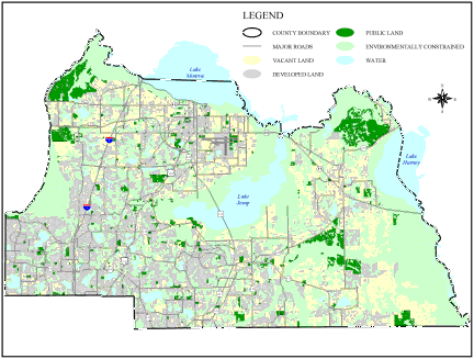
Figure 4: Developable Land
The remaining land, which is represented by yellow in Figure 4, is vacant developable land. Criteria to identify potential redevelopment areas are currently being developed. The process for identifying potential redevelopment areas will be the calculation of structural value to land value ratio.
While this analysis identifies developable land it also identifies where existing development is located. Parcels with existing development are then used to calculate the current year socioeconomic data.
ANALYZE EXISTING DEVELOPMENT
Analysis of existing development is performed at the parcel level. The type of development on a parcel is identified through information contained in the Tax Parcel Database. This information is collected and maintained by the County Property Appraiser’s Office.
Attributes from the Tax Parcel Database which are used include; Department of Revenue Use Code, Structural Value, and Building Square Footage. The Department of Revenue Use Code (DOR Code) provides a detailed identification of the use of each parcel. The Property Appraiser Office may use over 100 DOR Code to identify how a parcel is being used. The DOR Codes are consolidated into the seven Socioeconomic Data categories which are identified as ZData Land Uses in this analysis (See Figure 5).
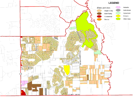
Figure 5: Existing Development
The seven Socioeconomic Data categories are broken into two separate files. Socioeconomic Data 1 (ZData 1) which represents residential information and Socioeconomic Data 2 (ZData 2) which represents employment data. ZData 1 includes information on Single Family units, population and automobiles per household, Multi Family units, population, and automobiles per household, and Hotel/Motel/Timeshare units, occupation rates and occupants. ZData 2 includes information about Industrial Employment, Commercial Employment, Service Employment and School Enrolment. With only seven broad ZData Land Uses it is fairly easy to accommodate all of the detailed DOR Codes.
CALCULATE CURRENT YEAR SOCIOECONOMIC DATA
The current year socioeconomic data is calculated by applying residential and employment factors to the existing development totals. Residential factors include:
Employment factors include:
ZData Land Uses are aggregated from the parcel level to the Traffic Analysis Zone (TAZ) level. The ZData is calculated by multiplying the ZData Land Use Acres by the residential and employment factors, except in the case of Single Family population where the SF/PPH factor is multiplied by the total number of Single Family parcels. Each TAZ has independent residential and employment factors that can be adjusted to reflect changing development trends. Figure 6 is a screen capture from ZGIS that shows the user interface for changing the residential and employment factors.
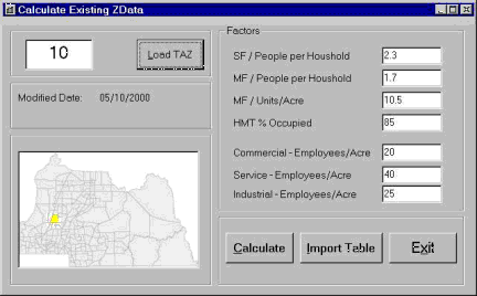
Figure 6: TAZ Factors
When the factors for each TAZ have been reviewed and adjusted, the ZGIS application will calculate the current year ZData. The calculation of the ZData can be quickly re-run if it is necessary to adjust some of the residential or employment factors.
The remainder of the process flow diagram is dedicated to producing the forecasted ZData.
ANALYZE HISTORICAL LAND USE CONSUMPTION RATES
Historical land use consumption rates are an important factor in understanding development trends. These consumption rates can be calculated by analyzing tax parcel data, future land use designations and developable land. The Tax Parcel Database contains a Year Built field that records the date of construction for every building. The Year Built data is used in conjunction with the DOR Codes to identify development trends for each land use. Figure 7 shows the historical development pattern throughout the entire study area.
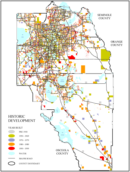
Figure 7: Historical Development for the Orlando Metropolitan Area
The historical land use consumption rates are used to help refine population and employment demand numbers.
DEVELOP POPULATION AND EMPLOYMENT DEMAND
Population and employment demand numbers for counties in the State of Florida are available from the Bureau of Economic and Business Research (BEBR). BEBR data is used as a starting point in the development of refined population and employment demand numbers. In this process, the demand numbers are broken down into sub-market areas within each county.. The sub-market areas are consistent with existing TAZ boundaries, and each sub-market contains several TAZs. The residential and employment sub-markets were developed independent of each other.
Population demand numbers are distributed at the sub-market level based on housing development trends, planned development and availability of developable land. Employment forecasts are based on recent leasing activity, recent or planned development, apparent patterns of land acquisition, and evaluations of demand generating factors for non-residential land uses. Demand numbers for each sub-market can be easily updated through the ZGIS user interface. (See Figure 8)
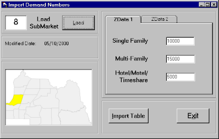
Figure 8: Sub-Market Demand Numbers
In order to develop future land use consumption rates, population and employment demand numbers were used in conjunction with the historical land use consumption rates.
CREATE FUTURE LAND USE CONSUMPTION RATES
Future land use consumption rates are derived from the analysis of historical land use consumption rates and the development of population and employment demand numbers. Future land use consumption rates define how land uses are consumed in a forecasted development pattern. These rates vary between sub-markets and are applied at the parcel level.
ASSOCIATE FUTURE LAND USE DESIGNATIONS WITH DEVELOPABLE LAND
The association of future land use designations with developable land was accomplished by overlaying local government future land use layers on the developable land layer. This process defines what types of development can occur. Figure 9 depicts future land use designation on developable land within this TAZ.
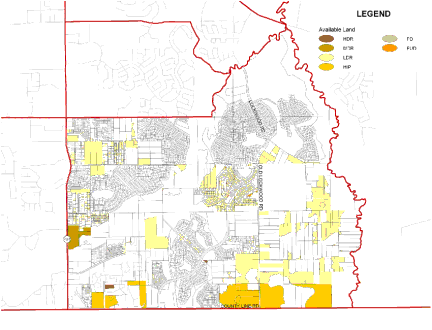
Figure 9: Developable Land with Future Land Use Designations
Development of the growth allocation model involved an assessment of the long range planning efforts conducted by each of the local governments. Future land use designations developed at the local planning stage impact growth patterns. The potential impacts of these local planning efforts are displayed in a regional transportation context in the results of this analysis.
Each local government has undertaken an Evaluation and Appraisal Report (EAR) Process for their respective comprehensive plans. Adopted Comprehensive Plans and EAR analyses provided a reflection of how a community’s growth pattern will change over the next 20 years. Incorporating local government Comprehensive Plans into this process assists METROPLAN ORLANDO in consensus building with the local governments. Developable land with the future land use designations is then run through a developable land suitability ranking in order to determine the development potential of each parcel.
DEVELOPABLE LAND SUITABILITY RANKING
The developable land suitability ranking is achieved by creating development indicators which are derived from parcel data, utility information, accessibility to existing and planned roads, and other influences. The results of this analysis assists in creating a potential development pattern. Each future land use designation is ranked separately with respect to those development indicators which provided the most influence. Development indicators can be weighted differently for the various types of development. (See Figure 10)
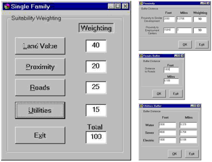
Figure 10: Developable Land Ranking Calculations
APPLY CONSUMPTION RATES TO DEVELOPABLE LAND RANKING
Consumption rates are applied to the developable land in order to produce a potential development pattern. This is accomplished by assigning each sub-market with population and employment demand numbers (See Figure 8) and each TAZ with residential and employment development factors (See Figure 6).
PRODUCE PROJECTED DEVELOPMENT PATTERN
The projected development pattern is produce by applying the consumption rates and demand numbers to the developable land ranking. This produces a projected development pattern at the parcel level. The projected development allocates the demand numbers at the parcel level based on residential and employment development factors. Development factors determine how much land is needed to accommodate population and employment demand. Development is allocated at the parcel level and then aggregated to the TAZ level. Each of the ZData land uses is projected separately.
CALCULATE SOCIOECONOMIC DATA PROJECTIONS
Socioeconomic data projections are calculated based on the distribution of population and employment demand numbers. Demand numbers are broken down into sub-market areas and are then allocated to the parcel level based on a development suitability rank that each parcel receives. The population and employment numbers are distributed to the parcel level and then summarized up to the TAZ level. The TAZ summary data is then written out to the ZData file format.
The socioeconomic data projections can be re-calculated by adjusting any or all of the following input variables:
Re-calculating these variables can result in the redistribution of the population and employment demand numbers. Adjusting these variables can create alternate development scenarios.
AUTOMATED MAPPING
Canin Associates has also developed an automated mapping interface for the ZGIS application. (See Figure 11) The automated mapping interface has been designed for the novice GIS user. This interface enables the end user to quickly access the GIS data and review the ZData at the TAZ level.
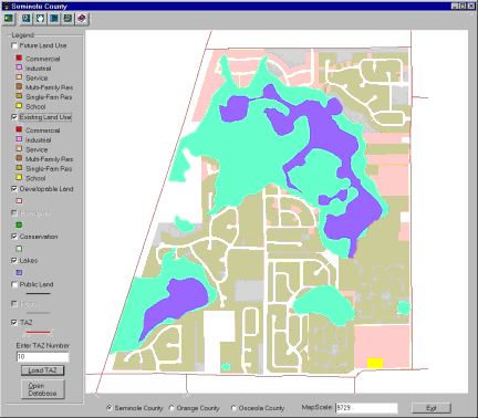
Figure 11: Automated Mapping Interface
The end user can zoom to a specific TAZ by entering the TAZ number into the "Enter TAZ Number" box and clicking on the "Load TAZ" button. The various GIS layers can be clicked on and off in the legend. The end user can also review the ZData that is associated with the TAZ by clicking on the "Open Database" button. (See Figure 12)
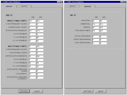
Figure 12: ZData Review
Figure 12 shows the ZData for 1996 and 2020 for TAZ 10. METROPLAN ORLANDO uses these automated mapping functions to quickly plot TAZ maps and their associated ZData.
KEY PLANNING ISSUES
Key Planning Issues
As part of the initial assessment process, key planning issues in the study area were identified which could have long term impacts on growth projections and their traffic zone allocation. These key planning issues are specific to the Central Florida area. Other areas that are experiencing dynamic growth patterns may have to evaluate the impacts of similar planning issues. Several significant development trends impact the model and allocation process:
PROCEDURES AND PROTOCOLS FOR CONTINUOUS UPDATING
Documentation for continuous updating and maintenance of the database was compiled, which included a data dictionary for all of data layers, detailed procedures for data preparation, and protocols for obtaining and updating data. In order to achieve this objective, it is important to have all agencies follow a uniform protocol. The data dictionary describes all of the attributes contained in each data layer. The procedures for data preparation are detailed instructions of the steps required to prepare data for input into the ZGIS Application. The protocols describe when data should be updated, who to contact, and how to obtain the data. The following data layers are included in the procedures and protocols; Tax Parcels, Future Land Use, Existing Land Use, Road Network, Urban Service Area, Wetlands, 100-Year Floodplain, Utility Data, TAZ Maps, County Boundaries, Municipal Boundaries, and Water Management District Data. METROPLAN ORLANDO is currently working with the local governments on an inter-local agreement keep the data up to date.
ESTABLISH INTERACTIVE WORLD WIDE WEB SITE
METROPLAN ORLANDO intends to develop a World Wide Web (WWW) site to facilitate the exchange of information between METROPLAN ORLANDO and the local governments. This WWW site will house tools that would enable local governments to create and print maps in their own offices. The site will also be used to exchange GIS and Socioeconomic data. Local governments will be able to download specific GIS and Socioeconomic data files directly from the site without having to make data requests through METROPLAN ORLANDO. The site will also house a place where local governments can exchange ideas or ask one another about data sources. This process would save time for both METROPLAN ORLANDO and local government staff. Another potential function of the site will be the ability to upload GIS data from the local governments. The implementation of a WWW site at the end of this process should enable all parties to exchange and develop data more freely and cost effectively.
CONCLUSIONS
Land use allocation modeling is in its infancy compared to the sophistication of transportation modeling applications. The ability to perform land use allocation modeling has historically been performed at a gross scale in order to determine potential development trends. The availability of detailed GIS data, specifically parcel data, has enabled land use allocation modeling to move towards an unprecedented degree of accuracy. Such accuracy will depend on the continued support of all local governments that are involved. The improved degree of accuracy in land use allocation modeling should also improve the accuracy of transportation modeling applications.
Improvements in the detail and accuracy of GIS data will allow GIS professionals to model processes in the built and natural environments with ever increasing accuracy.
Acknowledgments
METROPLAN ORLANDO has undertaken a monumental task in developing this land use allocation model for creating socioeconomic data. Their efforts are being applauded throughout the State of Florida. All 27 of the local governments within the study area have been supportive in developing this new approach to land use allocation modeling. Canin Associates would also like to acknowledge their sub-consultants who have participated in various ways throughout this process. Sub-consultants include; Leftwich Consulting Engineers, Inc., Real Estate Research Consultants, Inc., and Environmental Systems Research Institute, Inc..
AUTHOR
Craig A. Batstone
GIS Manager, Associate
Canin Associates, Inc.
Orlando, Florida 32801
Tel: (407) 422-4040
Fax: (407) 425-7427
E-mail: cbatstone@canin.com