Bill Medeiros
Have GIS, Will Travel: Using GIS as an Interactive
Decision Support Tool in Community Meetings
The Maui Planning Department is the lead planning
agency for the County of Maui, Hawaii. The county
is made up of four major
islands: Maui, Molokai, Lanai and Kahoolawe.
This presents special
problems in providing accurate land information
at community meetings. In
1996, the department opted for portability
in developing a laptop-based GIS
to support its community planning program.
After many meetings and much
travel over land and sea, GIS has become an
integral part of the county's
planning process. This paper will document
the sometimes bumpy road to interactive GIS.
BACKGROUND
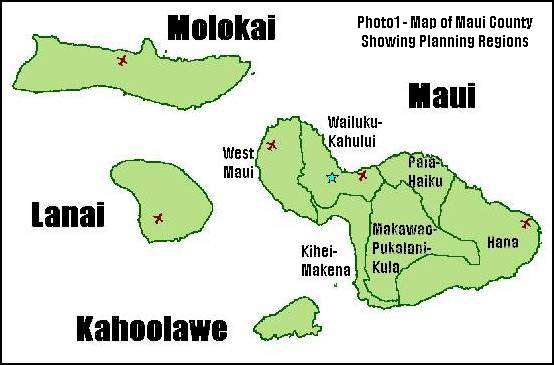
The County of Maui is made up of four major islands: Maui, Molokai, Lanai
and Kahoolawe. The four islands are divided into nine (9) community
planning regions (see Photo 1). County regulations require that public
hearings on amendments to the regional community plans be held within the
affected region. This presents special problems as some of the regions are
only accessible by aircraft or boat.
 In 1997, the County Planning Department was midway through a
comprehensive update of the regional community plans. The update
included dozens of proposed amendments which affected scores of
properties within each community plan region. All of these changes had to
be reviewed by the appropriate planning commission and then transmitted
to the Maui County Council (the County's legislative body and final
authority on planning and zoning issues) for review and adoption.
In 1997, the County Planning Department was midway through a
comprehensive update of the regional community plans. The update
included dozens of proposed amendments which affected scores of
properties within each community plan region. All of these changes had to
be reviewed by the appropriate planning commission and then transmitted
to the Maui County Council (the County's legislative body and final
authority on planning and zoning issues) for review and adoption.
During the course of the Council's review of the update of the
Kihei-Makena Community Plan, it became readily apparent that the use of
hard copy exhibits was adversely affecting the
planning process. Whenever a complex question arose, the process would be
put on hold while the department researched the issue and then transferred
the findings onto an acetate overlay. The overlay would be draped over a
hand-colored display map (1:24,000 scale) of the region. Delays of several
weeks were commonplace.
Finally, the County
Council and the Planning Director agreed that the situation had become
untenable. The only solution was to
develop a fully functional GIS which could be used to support the Council's
deliberations on the community plans. The staff of the Office of Council
Services and the Department of Planning were directed to deliver a
working GIS for the Kihei-Makena region within 90 days.
THE PROJECT TEAM AND THEIR APPROACH
The project team was made up of Wayne Boteilho (Legislative Analyst within
the Office of Council Services), Walle Landenberger and Bill Medeiros
(Cartographic Technician and Planner, respectively, within the Planning
Department). The team immediately realized that, while replacing hand-colored
maps with computer-generated maps would improve quality, paper maps were
not going to be the answer. What was really needed was a fully
interactive GIS that could be taken out to community meetings
and be able to answer questions on-the-fly. Once this goal was set,
the team divided up the workload and dove in.
The initial step was developing
the system specs. This turned out to be the easy part. Portability
required using a laptop. Both Planning and Council Services were
already using Microsoft Windows as their base operating systems.
It didn't take a rocket scientist to figure out that if you needed to
run GIS on a Windows laptop, you had to get ArcView.
 After purchasing
a laptop and a copy of ArcView (version 3.0a), the Planning
Department licensed digital parcel data for the Kihei region from
an Oahu GIS vendor, GDSI Hawaii. Using the parcel base, Planning began
to develop layers of Community Plan designations and zoning.
Planning also acquired GIS data from the
Hawaii Office of State Planning. However, as is commonly the
case, the datasets were in different map projections. The
State data had to be reprojected into the County's map
projection and datum. Initially, this had to be outsourced. Later,
with the help of the Esri CA/NV/HI/GU Regional Office staff,
the Esri Hawaii User Group was able to figure out the answer
to a particularly pesky
problem involing trying to convert between Hawaiian datums. Once this was
resolved, the Planning Department was able to do reprojections
inhouse using ArcView.
After purchasing
a laptop and a copy of ArcView (version 3.0a), the Planning
Department licensed digital parcel data for the Kihei region from
an Oahu GIS vendor, GDSI Hawaii. Using the parcel base, Planning began
to develop layers of Community Plan designations and zoning.
Planning also acquired GIS data from the
Hawaii Office of State Planning. However, as is commonly the
case, the datasets were in different map projections. The
State data had to be reprojected into the County's map
projection and datum. Initially, this had to be outsourced. Later,
with the help of the Esri CA/NV/HI/GU Regional Office staff,
the Esri Hawaii User Group was able to figure out the answer
to a particularly pesky
problem involing trying to convert between Hawaiian datums. Once this was
resolved, the Planning Department was able to do reprojections
inhouse using ArcView.
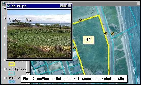
While the Planning Department worked at acquiring and developing
base layers for the GIS, Council Services contracted Royce Jones
of GDSI Hawaii to provide GIS support and to digitize specific
data layers requested by the County Council. These layers
included historic and cultural features, wetland areas and
proposed roadways. Council Services also scanned photographs
taken during the Council's visits to the various sites. These
scanned photos were loaded into the machine and pulled up using
ArcView hotlinking tool. (See photo 2)
THE SYSTEM MAKES ITS DEBUT
In June 1997, the County Council prepared to take up the Kihei
plan again. The team feverishly worked to get the data double-checked
and edited. Of course, an hour before the meeting, the machine crashed and
the entire project had to be rebuilt from scratch. The work continued as
the meeting started and the Council went through the initial items
on the agenda. Finally, the lights went down, the digital
projector was switched on and the outline of the Kihei-Makena
Community Plan region came up on screen.
 The system worked flawlessly. The Planning staff explained the various
data layers while Royce Jones ran the machine. Zoom in. Query
the ownership of a parcel. Zoom out. Show all the proposed
amendments to the community plan. Zoom in. Identify which
changes are in proximity to defined wetlands.
After a few questions about the system,
the Council started to discuss the Kihei community plan in earnest.
As the discussion began to center on the amount of vacant
hotel-designated lands within the region, the staff jogged over to Royce
and whispered, "Building value equals zero and CP equals 200."
The system worked flawlessly. The Planning staff explained the various
data layers while Royce Jones ran the machine. Zoom in. Query
the ownership of a parcel. Zoom out. Show all the proposed
amendments to the community plan. Zoom in. Identify which
changes are in proximity to defined wetlands.
After a few questions about the system,
the Council started to discuss the Kihei community plan in earnest.
As the discussion began to center on the amount of vacant
hotel-designated lands within the region, the staff jogged over to Royce
and whispered, "Building value equals zero and CP equals 200."
On screen, the parcels started to draw up in ArcView's standard selection color.
Staff leaned into the microphone and said, "The properties
highlighted in yellow are vacant and designated for hotel use."
We haven't used very much clear acetate since then. And three years later,
the system continues to impress. We make a concerted effort to add a little
more functionality each time we start up a new project. We work diligently
on developing new data as well as verifying and editing existing data.
Incremental improvements, no matter how small, add up over time.
WHERE ARE WE NOW
ArcView has not changed the world as we know it. But it has made
us more able to do the job that the taxpayers of Maui pay us to do.
Nor does GIS guarantee better decisionmaking. But it does much
to promote better informed decisions.
Since 1997, the GIS has been used in the Community Plan updates for
three regions: Kihei-Makena, Lanai and Wailuku-Kahului. The Planning
Department is already gearing up for the Molokai update later this
year. The GIS has also been used to support major zoning projects
such as the Lanai Comprehensive Zoning project which rezoned over
800 individual properties.
There has also been an
interesting side benefit to our decision to use interactive GIS
in meetings rather than paper maps. Participants, no matter
which side of an issue they are on, feel more a part of the
process when they can see the information live and can pose
questions and see the results come up on screen. The GIS
has also quickly resolved potential disagreements or
misunderstandings and kept meetings on track and let the
participants focus on the key issues.
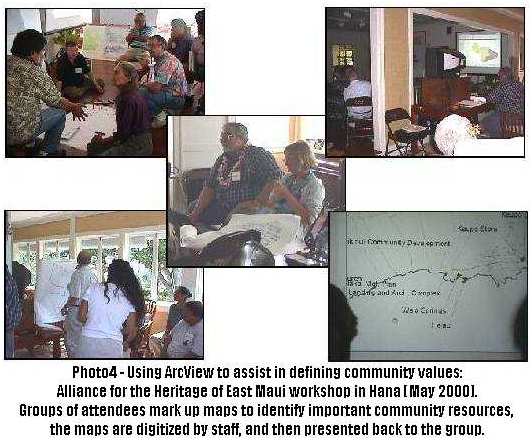 GIS has become an integral part of
the planning process within the County of Maui. The system has
been taken on the road to community meetings and public
hearings in school cafeterias, community centers and libraries
throughout the county. The County has begun to utilize GIS
to support community-based efforts in areas such as disaster
preparedness and the identification of community-defined
cultural resources. (See photo 4)
GIS has become an integral part of
the planning process within the County of Maui. The system has
been taken on the road to community meetings and public
hearings in school cafeterias, community centers and libraries
throughout the county. The County has begun to utilize GIS
to support community-based efforts in areas such as disaster
preparedness and the identification of community-defined
cultural resources. (See photo 4)
In 1999, Esri recognized the efforts of the GIS team with
a Special Achievement in GIS award. This proves that a
small-scale GIS can make it to the big leagues. In March
of this year, the County initiated a reorganization to move
the Planning Department's GIS team into the Office of the
Managing Director in order to promote countywide GIS. To
this date, seven County agencies, including the Department
of Public Works, County Civil Defense and the Maui Police
Department have begun GIS projects.
THE LESSONS WE'VE LEARNED
We have learned a lot in these last three years. We have
tried share this knowledge with others in Maui and throughout
the state through conferences and user group meetings.
This paper gives us the opportunity to share some of
what we have learned with folks outside of Hawaii.
And, if there is one thing that we have learned, it
is that you don't need a multi-million dollar system to
create an effective GIS. A clear focus on a specific goal
or issue, a little ingenuity and a lot of hard work can
go a long way in reducing costs and maximizing the
potential for success.
Here are our top ten keys for a successful GIS:
- First, get the right people. This is half the battle right here.
If you get the right people on your team and get the right
consultants, then you will have a shot at a successful project. Get
the wrong people, and it will be uphill the whole way.
- Get the right software. For us, the right software is ArcView (or
as we say in Maui: ArcView no ka oi!). Whatever software you
choose, be sure that there are other people in your area already
using it. And if vendors want to show you a demo, make sure
that it is the real software running real data. Powerpoint is
not GIS.
- Memory is more important than megahertz. When purchasing
hardware, people tend to over-estimate the importance of
processor speed. Most of our experience shows that you
will run out of memory (especially RAM) before you come close to
exceeding the CPU's capacity. This is particularly the case if
you use large raster files, such as aerial photos or DRGs.
- Find one clearly defined goal and go get it. It is easy
to get off track, so pick a goal and stick to it until you
deliver it. And remember the LHF principle
(LHF means "Low Hanging Fruit"). Do what is
achievable and start getting results right away.
- Walle's Law: Everybody does grunt work. There will always
be more than enough work for everyone, so everyone works.
Work also includes lobbying and signing checks -- and
occasionally, begging and scrounging.
- Bill's Corollary to Walle's Law: Know your data. If you are
going to be running GIS live, you have to know what data you
have and what all the codes mean. And the best way to know your
data is the work on the data yourself. Also, try to anticipate
any off-the-wall questions that may come up. Community meetings
tend to have free flowing discussions, so bring along any data that may
be meaningful to the community, even if the issue isn't
on the agenda and even if the issue is not directly within
your agency's purview.
- Know your software. Equally important, you need to know the ins
and outs of your software. Luckily, ArcView is easy to use and
quite simple to customize using free scripts and extensions.
For example, the Named Extents sample extension has proven to be
incredibly useful. This extension creates a drop down menu
where you can easily define geographic areas of
interest and then quickly navigate to these areas during
your presentation.
- Make the ArcScripts webpage your second home. If your program is
rolling in dough, then hundreds of free scripts and extensions
may not interest you. But for the rest of us, funding is always
a problem. Esri's ArcScripts webpage is like having a full-time
GIS programmer working for you for free.
- Your best friends hang out in user groups. So, how about having a
few dozen GIS geeks working for you. Your local Esri User
Group represents an incredible resource. Free advice.
Free scripts and extensions. And if you don't have an Esri User
Group near you, then check out the user group websites (the
Esri Maui User Group website is at:
http://www.maui.net/~mauigis/Esrimug.html).
- Your Esri Regional Office is YOUR Esri Regional Office. Still not
satisfied? OK, how about having hundreds of GIS professionals
ready to help you out. That's what Esri is there for. And it
all starts at your friendly, local Regional Office. These folks
are there to help make your GIS project a success. We cannot
thank the CA/HI/NV/GU Regional Office enough for all their support
throughout our sometimes stressful, but ultimately successful, project.
On that note, let me pass along a big mahalo or two to all the folks
that have helped us out along the way.
ALOHA AND MAHALO
First, let me thank the rest of the project team:
Wayne Boteilho, Legislative Analyst, Office of Council Services
Walle Landenberger, Cartographer, currently on special assignment as GIS
Project Team Leader, Office of the Mayor
 Eric Matsuo, former GIS Intern, Maui Community College
Cooperative Education Program
Eric Matsuo, former GIS Intern, Maui Community College
Cooperative Education Program
Ray Legsay, former GIS Intern, Maui Community College
Cooperative Education Program
Robin Wainui, GIS Intern, Maui Community College
Cooperative Education Program
Second, the folks behind the data and the software:
Royce Jones, "Mr. GIS", founder of GDSI Hawaii and currently head of the
Esri Hawaii Office.
Craig Tasaka and the staff of the Hawaii State Office of Planning, GIS Program.
Lee Johnston and staff of the Esri California/Nevada/Hawaii/Guam
Regional Office for their patience and support. And especially a
big mahalo for nominating us for the 1999 SAG Award.
Thanks also to Esri for giving the folks from Maui the opportunity
to toss in our two cents at User Conference 2000.
Next, the folks that got us into this back in 1997:
David Blane, former Director of the Maui Planning Department, currently
Director of the Hawaii State Office of Planning.
Lisa Nuyen, former Director of the Maui Planning Department.
Alan Arakawa, former member of the Maui County Council and former
Chair of the Council Planning Committee.
Alice Lee, former member of the Maui County Council and currently
Director of the Maui Department of Human Concerns and Housing.
James "Kimo" Apana, former member of the Maui County Council and currently
Mayor of the County of Maui.
Pat Kawano, chair of the Maui County Council.
Sol Kaho'ohalahala, former member of the Maui County Council and currently
State Representative for the 7th District (Lanai, Molokai and West Maui).
Charmaine Tavares, member of the Maui County Council and current chair
of the Council Planning Committee.
J. Kalani English, member of the Maui County Council.
Wayne Nishiki, member of the Maui County Council.
Dennis Nakamura, member of the Maui County Council.
And finally, much thanks go out to you for reading this paper (or worse yet, actually sitting
through my presentation). I hope some of this has proven helpful to you.
Mahalo nui loa from the Maui GIS folks...
Bill Medeiros
Former Senior Planner (Community Planning and GIS)
Department of Planning
Currently Senior GIS Analyst, Office of the Managing Director
County of Maui