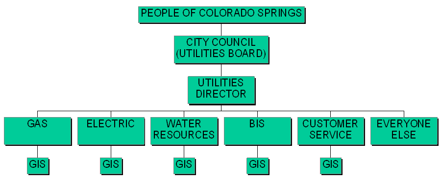
Figure 1. CSU GIS Organization
Colorado Springs Utilities (CSU) is a 4-utility company, wholly owned by the City of Colorado Springs.
Figure 1. CSU GIS Organization
The City Council serves as our Board of Directors and our customers are in effect our shareholders (Fig. 1). Electric and Gas are separate Departments, while Water and Wastewater are combined in the Water Resources Department. In addition, there is a "headquarters" consisting of the central Utilities administration. Each Department, including some central staff departments, contains its own GIS section, whose various responsibilities reflect the Department-unique needs. In addition, the City government GIS section (not part of Utilities) contributes zoning and planning data and the County government GIS section contributes county-wide parcel data.
The CSU GIS system is Unix-based, using Sun workstations running the Sun Solaris operating system. There are 75 Sun workstations being used, 33 in the Water Resource Department. The data servers are all Unix-based. Efforts to migrate FIMS access to desktop PCs consist of several intranet applications and (eventually) an adaptation of the Arcinfo 8 Desktop package. There are some workstation/PC interfaces in the Design-to-As-Built process, and we'll refer again to them when we get to that discussion.
Since this presentation is concerned with water GIS data processes, the remainder of the discussion will consider primarily the Water Resources Department GIS system, with other parts of the organization mentioned as interfaces occur.
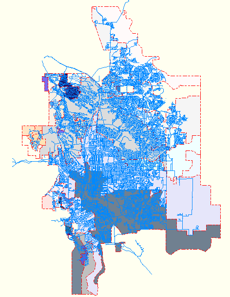
Figure 2. CSU Distribution Mains and Pressure Zones
The chief access to water FIMS data is through an in-house application called the Map Builder program. This is a large Arcinfo AML program that runs on Sun workstations and from PCs using (in our case) the "X-Term" application from Novell's LAN Workplace Pro package. Originally conceived as a mapping program, it has evolved into the primary vehicle for users and other applications to access water and wastewater data.
The Map program, using the entire FIMS database, can find specific locations using nine different criteria, and also can retrieve previously saved map displays (Appendix, Fig. A1). Forty-seven coverages are available, as shown here on the Utilities and City Menus (Figs. A2 and A3). For many of these coverages, annotation and/or text can be selected for display (Fig. A4). Six user-specified (non-standard) coverages can be entered and displayed. There is a full set of geometric display adjustments (zoom, pan, etc.) and several built-in analysis functions (Fig. A5). Finally, there is a full set of output options, including DXF and shape files of all displayed data in any arbitrary area (Fig. A6).
Having waded through all the background information, it's finally time to get to the meat of this paper: the Design-to-As-Built process, and the part the FIMS GIS plays in that process.
There are two tracks that water design and construction follow. One is internal, by which the requirement, design and construction all occur within the Water Resources Department. The external track involves a developer or builder submitting a water plan for a project and, upon approval, building the necessary water facilities. Though similar in many ways, these processes differ enough to be discussed separately.
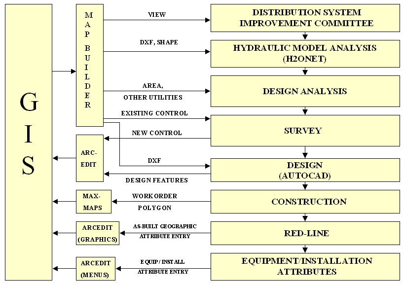
Figure 3. The Internal Design-to-As-Built Process
Internal requirements originate from the Department's Distribution
System Improvement Committee. During the Committee's review and approval,
real-time Map Builder displays of FIMS GIS data, projected on a screen,
are used as discussion aids. Each project is analyzed for hydraulic soundness
using MW-Soft's "H2ONet" application. This application uses FIMS transmission
water main data input from Map Builder-generated DXF or shape files, generated
at the time of analysis to ensure that data are the most current.
After the necessary reviews and approvals, a project is referred to the Design Section. The first step here is a preliminary analysis. The Design Supervisor makes a Map Builder plot of the area in question, using the appropriate FIMS GIS coverages. The intent here is to identify and resolve major issues before they become real problems. Areas of interest include things like rights-of-way and easement issues, landform constraints, facility impacts to or from other utilities, and survey control needs.
The in-house surveyors use the preliminary analysis results to perform a verification survey of all existing facilities in the design area. The surveyors verify existing control points as necessary. If new control points are needed, the surveyors establish them. One of the GIS coverages maintained by the central BIS-FIMS section is a city-wide coverage of "FIMS control points." This is a collection of highly accurate surveyed and often "GPS'd" points, throughout the Utilities service area, which the surveyors use as their base. Data the surveyors obtain on any new control points are forwarded to BIS-FIMS to be added to this coverage.
After foreseeable issues are handled and the survey performed, the project is referred to a designer. The designer creates a DXF file using the Map Builder. The Map Builder composes a single DXF file with a separate layer for every combination of coverage, feature class, annotation and text present on the display. Imported into AutoCAD, this GIS data becomes the design baseline. The AutoCAD design, coupled with the GPS or surveyed points, is then the controlling drawing document through the construction process. A copy of this design drawing is sent to the GIS section for entry into the FIMS database, labeled as "design data." Entries are made to 4000-ft-square tiled coverages and saved to a master water FIMS GIS database consisting of 330 tiles that contain water data.
Early in the process, a master work order is generated. The CSU work order system is a highly customized version of PSDI's "Maximo." BIS-FIMS has developed an interface between Maximo and FIMS called "MaxMaps." Using this interface, the work order creator outlines a polygon over a FIMS GIS display of the project area. This polygon and all the appropriate utility features that it includes are then tied to the work order and hence to any related images, including the design drawing and later the as-built drawing. This constitutes the geographic representation of the project in the FIMS GIS database. Because these polygons may overlap, they are maintained only in an SDE database. The polygons will be used to zoom to a selected project, feature, or area and to retrieve electronic or scanned hard copy images of project drawings and documentation.
When construction is nearing completion, the Department GIS Section's GPS crew visits the project and obtains GPS positions of all point features (hydrants, valves, fittings, etc.) to decimeter accuracy.
The design drawing is red-lined to become the as-built drawing by an appropriate construction supervisor. This drawing is then forwarded to the GIS section for entry into the FIMS database. Since the features and their geographic attributes had been entered at the design stage, this entry consists of updating the data to actual positions based on the GPS data, adding any additional features, and changing the data status from "design" to "built." Once the changed tile coverage is sent forward, all master and working water database instances are updated within minutes.
The equipment and installation attributes are then added to each feature's attribute table through a menu-driven Arcedit application. Again, the tile coverage is sent forward, and will show up via the Map Builder application in the planning discussions for the next project in that area.
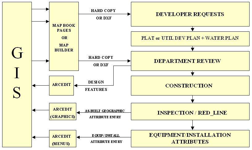
Figure 4. The External Design-to-As-Built Process
The external Design-to-As-Built process is actually simpler, since the developers do most of the work. However, it's harder to monitor. We can easily ensure that all internal designs and construction follow defined specifications and procedures, but this is not as easily done with a large number of developers and builders in a fast-growing community. Our approach is to employ reviews at specific points in the cycle, using the FIMS GIS as the geographic reference.
The FIMS GIS is present from the very beginning. Developers can (and do) go to our CSU Development Services Division to obtain map book pages of their area of interest for all utilities (gas, electric, water and wastewater). If these standard maps are not suitable, Development Services uses the Map Builder program to generate unique maps or DXF files.
During their design activities, developers may submit a recorded plat or a non-recorded Utilities Development Plan (UDP). Either of these includes planimetric and cadastral data, which is reviewed by the Customer Service Department's Development Services Division to head off any major issues, such as easements, zoning, address conflicts, etc. Upon approval, these are entered into special FIMS coverages that contain only proposed lots and street layouts. This data is then available to anyone else who has plans in the same area through the Map Builder program. In either case, plat or UDP, the developer must submit a separate "Water Plan", detailing plans for building the water and wastewater portion of the project.
The Water Plan is reviewed within the Water Resources Department for specification compliance, distribution main pressure and flow, collector capacities, easements, and so on using GIS data - usually in the form of a hard copy map book page. Hydraulic modeling using the H2ONet program is also performed at this point, as is a review of the impact on existing infrastructure (tanks, pumps, regulator valves, etc.). Covenants are reviewed for private water facility systems to ascertain that CSU and owner responsibilities are appropriate and clearly stated. Variances are considered and approved or forwarded to higher levels. The approved design, as before, is sent to the Water Resources GIS section for inclusion in the FIMS database as "design features."
As the development proceeds, the developer notifies the Water Resources Inspection section that their water construction is ready for inspection. This is when the design drawing becomes the as-built drawing. An inspector visits the site, ensures that all work is in accordance with specification or standard practice, and records and changes or deviations from the design on a copy of the design drawing. This red-lined drawing, coupled with any further notes taken by the inspector, becomes the "official" hard-copy As-Built Drawing. At this time, the GIS section GPS crew visits the site to obtain accurate positioning on all water system features.
The as-built drawing and the GPS positioning data are forwarded to the GIS section, where the design features are updated in the GIS to their actual location and configuration. From here on, the GIS-related actions are identical to those in our internal process.
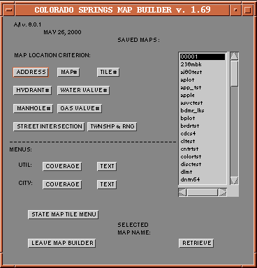
Figure A1. Map Builder Main Menu
The Map Builder Main Menu is the entry point to anywhere in our GIS
coverages. The design aim is to present all pertinent choices to the user,
avoiding hidden, cascading drop-down menus. Though this sometimes covers
up part of a map display, we accept this inconvenience.
***************************************************
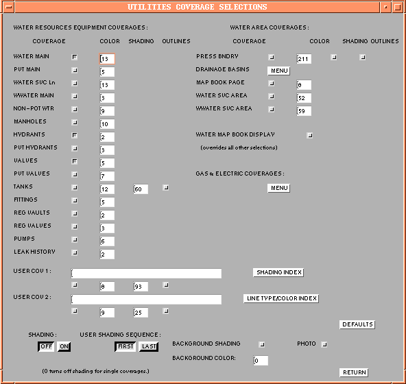
Figure A2. Map Builder Utilities Coverage Selection Menu
Though most selections are coverages in their own right, many are partial
or combined coverages that are selected or assembled in the background.
Note that there is a submenu for gas and electric coverages; this is due
to the 100-item AML menu limit.
***************************************************
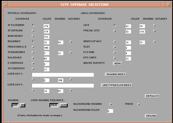
Figure A3. Map Builder "City" Coverage Selection Menu
These coverage selections are those that are not uniquely utilities
coverages. Generally speaking, these are the planimetric and cadastral
coverages.
***************************************************
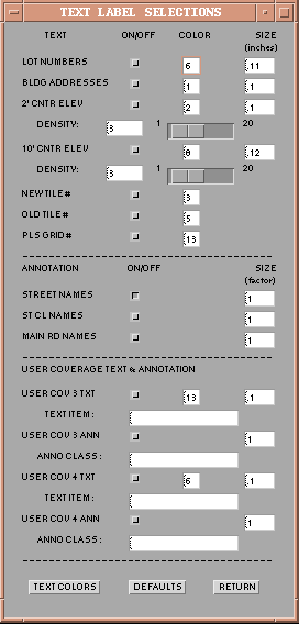
Figure A4. Map Builder "City" Text Selection Menu
This illustrates the types of choices available for either attribute
value text or annotation. The slider bars govern the frequency of
appearance of contour elevation tags
***************************************************
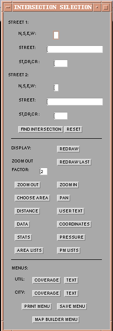
Figure A5. Typical Map Builder Locator Menu
The eight locator menus differ only in the top area, where the specific
location information is entered. Below this area, each locator menu presents
a full range of map area display options, several analysis tools, and a
set of further menus.
***************************************************
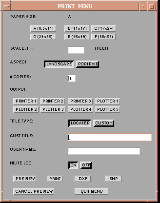
Figure A6. Map Builder Output ("Print") Menu
The Print Menu shows the wide range of output options available to
the user. Note that DXF and shape file outputs are also provided. As with
a plot, these outputs record whatever is displayed on the Arcplot screen:
a single DXF file with multiple layers or a set of shape files. (Not including
text and annotation in the case of the shape files, of course.)
***************************************************!