Development and Application of Geospatial Hydrologic Model Extension HEC-GeoHMS
James H. Doan, P.E.
|
|
Hydrologic Engineering Center
|
|
US Army Corps of Engineers
|
|
Davis, California
|
Abstract
The Geospatial Hydrologic Modeling Extension (HEC-GeoHMS) is a public-domain software package for use with the ArcView Geographic Information System. GeoHMS uses ArcView and Spatial Analyst to develop a number of hydrologic modeling inputs. Analyzing the digital terrain information, HEC-GeoHMS transforms the drainage paths and watershed boundaries into a hydrologic data structure that represents the watershed response to precipitation. In addition to the hydrologic data structure, capabilities include the development of grid-based data for linear quasi-distributed runoff transformation (ModClark), HEC-HMS basin model, physical watershed and stream characteristics, and background map file. GeoHMS as shown in Figure 1 is available for Windows 95/98/NT operating systems.
|
The development of HEC-GeoHMS began with contracted research at the Center for Research in Water Resources at the University of Texas and continues now under a Cooperative Research and Development Agreement (CRADA) between HEC and Esri.
|

Figure 1. Extensions Window with HEC-GeoHMS |
Table of Contents
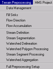
Background
Introduction
Technical Capabilities
Intended Application of HEC-GeoHMS
HEC-GeoHMS Development and Application
HEC-HMS Application
Closing Remarks
References
Author Information
Background
The Hydrologic Engineering Center�s (HEC) recent developments in Geographic Information System (GIS) tools for hydrologic and hydraulic modeling results from many years of interest in geospatial data usage. The earliest work was begun in the mid 1970's when HEC developed software based on the concepts developed in the Harvard University's School of Landscape Architecture, Honey Hill Project. That early work culminated with the development of the Spatial Analysis Methodology (HEC-SAM) which included a grid-cell data bank and analysis software for hydrologic and flood damage calculations. That early work had the same concepts as those of today, but the limitations in the computer hardware, GIS software, and data availability made widespread engineering applications difficult.
The current development builds on those early experiences and takes the technology to several practical engineering products including HEC-GeoHMS. HEC resurrected its earlier efforts by reviewing current GIS capabilities in association with Professor David Maidment from the University of Texas. HEC and Dr. Maidment formulated a watershed data structure that would link GIS and hydrologic models. From that time, the definition and content of the GIS and hydrologic data structures evolved into a hydrologic GIS preprocessor, PrePro. Taking advantage of the wealth of terrain and geographic data readily available over the Internet and from government agencies, PrePro delineates streams and watersheds and builds the hydrologic model structure for HEC-HMS. PrePro was the predecessor to HEC-GeoHMS.
The development of PrePro at the University of Texas was partially supported by HEC via the Corps' Civil Works R&D program. The effort also received substantial support from the Texas Department of Transportation as well as support from other national and international agencies. As a component of a Cooperative Research and Development Agreement between HEC and Esri, HEC-GeoHMS was developed as the successor to PrePro. HEC continues a research association with Dr. Maidment's Center for Research in Water Resources.
HEC has developed a number of GIS modules for specific tasks, such as processing terrain for drainage path, generating grid-based rainfall, etc. Those modules required users knowledgeable of UNIX, ArcInfo, hydrology, and a number of miscellaneous sub-programs. HEC-GeoHMS combines the functionality of those ArcInfo programs into a package that is easy to use. With this ArcView capability and a graphical user interface, the user easily accesses customized menus, tools, and buttons instead of the command line interface in ArcInfo. With GeoHMS, users who are new to GIS have access to powerful GIS operations.
GeoHMS uses readily available digital geospatial information to construct hydrologic models more expediently than manual methods. Also, development of basic watershed information will aid the engineers in estimating hydrologic parameters. After gaining adequate experience with using GIS-generated parameters, users can take steps to streamline the process of hydrologic parameter estimation.
Other GIS products that have been released or are under development by HEC include HEC-GeoRAS, a GIS utility for use with the HEC-RAS river hydraulics program, and HEC-GeoFDA, a GIS utility for use with the HEC-FDA flood damage analysis package.
Introduction
In recent years, advances in the Geographic Information Systems (GIS) have opened many opportunities for enhancing hydrologic modeling of watershed systems. With an openness to share spatial information via the Internet from government agencies, commercial vendors, and private companies coupled with powerful spatial algorithms, the integration of GIS with hydrologic modeling holds the promise of a cost-effective alternative for studying watersheds. The ability to perform spatial analysis for the development of lumped hydrologic parameters can not only save time and effort but also improve accuracy over traditional methods. In addition, hydrologic modeling has evolved to consider radar rainfall and advanced techniques for modeling the watershed on a grid level. Rainfall and infiltration are computed cell by cell providing greater detail than traditional lumped methods.
These advanced modeling techniques have become feasible because the many time consuming data manipulations can now be generated efficiently with GIS spatial operations. For example, the ability to perform spatial overlays of information to compute lumped or grid-based parameters is crucial for computing basin parameters, especially grid-based parameters. HEC-GeoHMS has been developed as a geospatial hydrology tool kit for engineers and hydrologists with limited GIS experience. The program allows users to visualize spatial information, document watershed conditions, perform spatial analysis, delineate subbasins and streams, construct inputs to hydrologic models, and assist with report preparation. Working with HEC-GeoHMS through its interfaces, menus, tools, buttons, and context-sensitive online help, in a windows environment, allows the user to expediently create hydrologic inputs that can be used directly with the Hydrologic Modeling System, HEC-HMS.
Technical Capabilities
Hydrologic modeling has evolved to represent the subbasin in more detail than the traditional lumped approach where hydrologic parameters are averaged over the basin. With the availability of radar rainfall and spatial data, hydrologic modeling on a grid level has introduced a more detailed representation of the basin. This distributive modeling approach utilizes the ModClark (Peters and Easton, 1996; Kull and Feldman, 1998) hydrograph transformation method, which tracks infiltration and excess rainfall on a cell-by-cell basis. To meet the needs of both the traditional lumped and distributed basin approaches, HEC-GeoHMS has the capability to develop HMS input files that are compatible with both approaches.
The current version of HEC-GeoHMS creates a background map file, lumped basin model, a grid cell parameter file, and a distributed basin model. The background map file contains the stream alignments and subbasins boundaries. The lumped basin model contains hydrologic elements and their connectivity to represent the movement of water through the drainage system. The lumped basin file includes watershed area, and reserves empty fields for hydrologic parameters. To assist with estimating hydrologic parameters, tables containing physical characteristics of streams and watersheds can be generated. If the hydrologic model employs the distributive techniques for hydrograph transformation (i.e. ModClark, and grid-based precipitation), then a grid-cell parameter file and a distributed basin model at the grid-cell level can be generated.
GeoHMS provides an integrated work environment with data management and customized toolkit capabilities, which includes a graphical user interface with menus, tools, and buttons. The program features terrain-preprocessing capabilities in both interactive and batch modes. Additional interactive capabilities allow user to construct a hydrologic schematic of the watershed at stream gages, hydraulic structures, and other control points. Physical characteristics of the watershed and river are computed and used to estimate hydrologic parameters. The hydrologic results from HEC-GeoHMS are then imported by the Hydrologic Modeling System, HEC-HMS, where simulation is performed.
The following capabilities are implemented in GeoHMS.
Data Management
GeoHMS performs a number of administrative tasks that help the user manage GIS data derived from the program. The data management feature tracks thematic GIS data layers and their names in a manner largely transparent to the user. Prior to performing a particular operation, the data manager will offer the appropriate thematic data inputs for operation, and prompt the user for confirmation. Other times, the data management feature manages the locations of various projects and also performs error checking and
detection.
Terrain Preprocessing
GeoHMS allows users to perform terrain preprocessing in a step-by-step fashion or in batch mode. In the step-by-step fashion, the user often has the opportunity to examine the outputs and make corrections to the data set, as appropriate. However, if the user has performed the terrain preprocessing a number of times, then batch processing will allow terrain preprocessing to be performed unattended.
Basin Processing
The emphasis of the subbasin delineation, processing, and manipulation capability is on flexibility, ease of use, and user interactivity. As the user subdivides a basin or merges many smaller subbasins together, the results of the operation are displayed immediately for the user�s confirmation. The ability to perform basin processing interactively is powerful because the results are presented quickly for user to make a modeling decision instead of having to reprocess the data. For example, the user can obtain a stream profile and look for significant grade breaks. If basin subdivision at a grade break is desired, the user just clicks on the profile at the grade break. Other tools allow user to delineate subbasins in a batch mode by supplying a data set of point locations of desired outlets.
HEC-HMS Model Support
GeoHMS produces a number of hydrologic inputs that are used directly in HMS. In addition, the program supports the estimation of hydrologic parameters by providing tables of physical characteristics of the streams and watersheds. While working with GeoHMS, the user can toggle GeoHMS on/off in order to bring in other ArcView extension programs to perform spatial operations and develop additional parameters for populating the hydrologic model.
Intended Application of HEC-GeoHMS
The application of HEC-GeoHMS is intended after the compilation and preparation of
the terrain data is completed. The assembly of GIS data can be performed using standard GIS software packages that support ARC Grid format. Even though this
paper provides some guidance and discussions on the proper approach for assembling data, GeoHMS is not intended as a tool for data assembly. When assembling data, it is important to understand how to use GIS software to put data of different types and formats into a common coordinate system. A few examples of required data are digital elevation model, digital stream alignments, and stream gage locations. The most important data, and often the most difficult, is a "hydrologically corrected" digital elevation model, DEM.
When the data assembly is complete, GeoHMS analyzes the terrain and spatial information to generate a number of hydrologic inputs. It is intended that these hydrologic inputs provide the user with an initial HMS model. The user can estimate hydrologic parameters from stream and watershed characteristics, and gaged precipitation and streamflow data. In addition, the user has full control in HMS to modify the hydrologic elements and their connectivity to more accurately represent field conditions.
HEC-GeoHMS Development and Application
HEC-GeoHMS is a set of ArcView scripts developed using the Avenue programming language and Spatial Analyst. It includes an integrated data management capability and a graphical user interface (GUI). Through the GUI, which consists of menus, tools, and buttons, the user can analyze the terrain information, delineate subbasins and streams, and prepare hydrologic inputs.
The relationship between GIS, HEC-GeoHMS, and HEC-HMS is illustrated in Figure 2. The GIS capability is used for heavy data formating, processing, and coordinate transformation. The end result of the GIS processing is a spatial-hydrology database that consists of the Digital Elevation Model (DEM), soil types, land use information, rainfall, etc. Currently, HEC-GeoHMS operates on the DEM to derive subbasin delineation and prepare a number of hydrologic inputs. HEC-HMS accepts these hydrologic inputs as a starting point for hydrologic modeling. With the vertical dashed line separating the roles of the GIS and the watershed hydrology, HEC-GeoHMS provides the connection for translating GIS spatial information into hydrologic models.
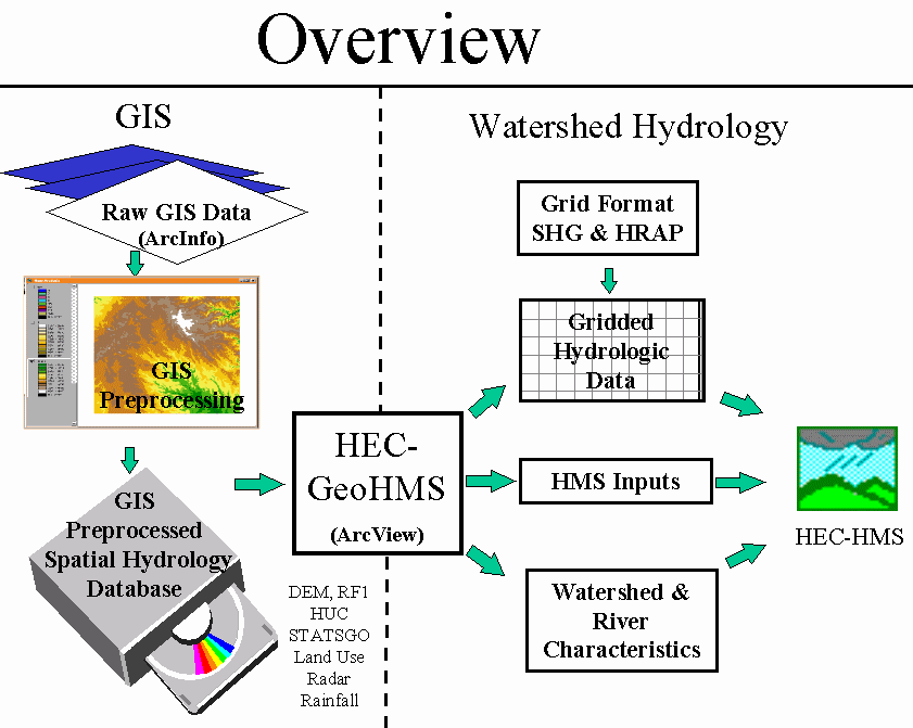
Figure 2. Overview of GIS and Hydrology Programs
The following contents describe the major steps in starting a project and taking it through the process.
Data Collection
With the large volume of spatial data available, it is important to identify the data that will meet project needs. Spatial data comes in many formats, resolutions, intended uses, quality, and prices. Prior to collecting data, the project specifications should be thoroughly reviewed for any recommendations. When the project does not specify a particular data set, review the project�s goals and objectives to help define acceptable data in terms of data storage, resolution, and accuracy. In addition, economic factors should be considered to determine the cost effectiveness in collecting and assembling the data or purchasing the data from a vendor. Whether the data are collected or purchased, the metadata should also be acquired to provide necessary documentation for the data.
GIS data can be collected and used with existing spatial data to document field conditions. For example, photographs of drainage structures as shown in Figure 3 and other field conditions can be geographically located with the street data to more effectively document these facilities and show their spatial relationships.

Figure 3. Field Documentation with Photographs
Data Assembly
The data assembly often requires efforts of an experienced GIS user. Because GIS data have many forms and formats, users often need to convert the data into a common coordinate system. For example, data describing the terrain should be in Esri�s ARC grid format and vector data, such as stream alignments and streamflow gage locations, should be in their shapefiles format. Being in a common coordinate system, these data sets can be overlaid and spatial operations can be performed on them. Often times, these data sets are provided in rectangular portions. When assembling data, especially the terrain, special efforts are required to insure that data are continuous along the edges. An example of a poor terrain data is shown Figure 4, where the lake has different elevations along the edges.
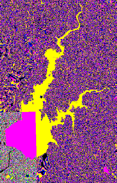
Figure 4. Terrain Data with Incorrect Elevations
In addition to the data format and coordinate system, the terrain data also needs to be "hydrologically corrected". The preparation of "hydrologically corrected" terrain data often requires much iteration through drainage-path computations. In order to represent the movement of water through the watershed, the "hydrologically corrected" DEM must have the proper accuracy and resolution to capture details of the stream alignments and watershed divides. Problems may arise when the watershed has low relief and the resolution is not adequate to represent the needed details.
Construction of a "hydrologically corrected" terrain model involves more complexity than combining tiled USGS�s DEMs into a unified DEM grid. The USGS�s DEM represents elevation averages at regular intervals and may not accurately represent stream locations and watershed boundaries. For example, stream and watershed delineation sometimes does not coincide with published data sources like the EPA�s RF1 and the USGS�s watersheds in the Hydrologic Unit Code (HUC). A "hydrologically corrected" terrain model must represent accurate stream patterns across the landscape, stream alignments, topographic ridges, stream confluences, internal drainage areas, and drainage facilities. Many factors, such as cell resolution, accuracy, topographic relief, and drainage facilities deserve careful consideration because they often affect the quality of the terrain model. In theory, combining GIS data sets of different resolutions is generally not recommended because of the difficulty in assessing the accuracy and the precision of the resulting data set. In practice, however, combining data sets of various resolutions is necessary due to lack of uniform data and data coverage.
In contrast to the effort required for the "hydrologically corrected" DEM, the "depressionless" DEM is simply constructed by filling in the sinks or depressions in the assembled DEM. Because of the complexity and effort required for constructing a "hydrologically corrected" terrain model, a "depressionless" terrain model often serves as a simpler substitute in the analysis as shown in Figure 5. For study regions with moderate to high topographic relief, the "depressionless" terrain model may be adequate for the analysis. For low-relief regions, however, the "depressionless" terrain model often needs additional work to adequately represent the terrain. For example, a watershed with flat terrain often requires editing to force proper drainage location.
Until better data quality and editing techniques are available, users may struggle with terrain data assembly. It is important to identify the issues with the data so that the user knows and fixes the problems. As an encouraging note, many governmental institutions, including the USGS and the EPA, are working to develop seamless terrain information and streams and watersheds information, which will ease the data assembly efforts.
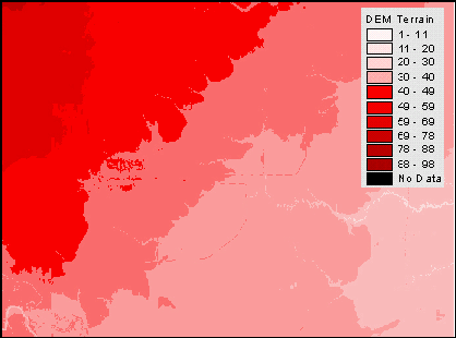
Figure 5. Continuous DEM Model
Terrain Preprocessing
In this step, a terrain model is used as an input to derive eight additional data sets that collectively describe the drainage patterns of the watershed and allows for stream and subbasin delineation. The first five data sets in grid representation are the flow direction, flow accumulation, stream definition, stream segmentation, and watershed delineation. The next two data sets are the vectorized representation of the watersheds and streams, and they are the watershed polygons and the stream segments. The last data set, the aggregated watersheds, is used primarily to improve the performance in watershed delineation. It is important to recognize that the watershed and stream delineation in the terrain preprocessing steps is preliminary. The main terrain preprocessing is performed in the MainView.
The objectives of the terrain preprocessing are shown below.
-
The terrain is processed and analyzed using the GIS 8-point-pour approach to determine flow paths. A "depressionless" terrain model as shown in Figure 6 is used as input in the analysis. The terrain analysis is computer intensive and some steps may require several hours depending on the size of the watershed and detail of the data and computer resources.
- After the terrain preprocessing is completed, the resulting data sets serve as a spatial database for the study. With the information centralized in the spatial database, pertinent data sets can be extracted for subsequent work on building the hydrologic models. The preliminary watershed and stream delineation output from the terrain preprocessing is shown in Figure 7.
- Preliminary watershed and stream delineation provides results that can be verified with published information to detect possible errors in the terrain model. If errors are detected in the terrain model, the DEM should be edited outside of the program. When the DEM has been revised to better represent field conditions, it should be processed again to update the spatial database.
Applying the GIS algorithms discussed below, the terrain can be processed in two ways: step-by-step or batch processing. With the step-by-step approach as illustrated below, data sets are derived after each operation. Greater control over the results is obtained because the user verifies the results and makes decisions before proceeding. For example, prior to performing the stream definition, it is good practice to use the Area tool and check the contributing area at several locations. This information on the area can help pick a threshold for adequate stream definition. With the batch mode, all of the inputs like the threshold and a few others are entered, and then the program generates all of the data sets. In a few instances, the batch mode may pause and prompt for more input to complete the terrain process. For example, if there are too many outlets, then the program will prompt for input whether stream segments serve as an outlet. When using the batch mode, there are some safeguards for changing the threshold to vary the detail of the stream definition. After the batch processing is complete, the user can use to the Identify Area tool to estimate a good threshold and then specify that threshold when setting up a hydrologic model.
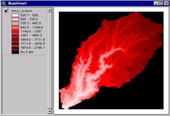
Figure 6. Depressionless DEM Used As Input

Figure 7. Preliminary Watershed and Stream Delineation Output
Features and Functionality
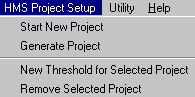
The HEC-GeoHMS extension adds features and functionality to the standard ArcView; special menus (Terrain Preprocessing, HMS Project Setup, and Utility), buttons, and tools are added to the standard ArcView GUI as shown in Figure 8. A number of capabilities related to terrain processing are under the Terrain Processing menu. Once the terrain processing is complete, the data can be extracted to support hydrologic model creation via the HMS Model Setup menu. The Utility menu allows users to perform some limited administrative tasks in assigning or changing a theme, which is to be identified and used by the program. Each theme will be assigned a unique name or "tag" by which it will be known to the program. The tags are names associated with themes that identify the role of the theme in the program. Buttons perform tasks after they are activated. On the other hand, the tools perform the task after they are activated and the user applies an action. Table 1,Table 2, and Table 3 show the menus, buttons, and tools added by HEC-GeoHMS when the MainView document is activated for terrain preprocessing.
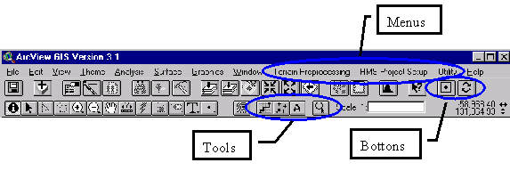
Figure 8. MainView GUI with GeoHMS Extensions Features Circled
Table 1. MainView Menus
|
Menus |
Descriptions |
|
|
The Terrain Preprocessing menu is used to process and analyze the terrain. It has the capability of processing the terrain in two ways: step by step or batch processing. It also has data management capability for tracking data sets as they are derived.
|
|
|
After the terrain has been processed, the HMS Project Setup menu is used to extract the processed terrain information from the MainView. The extracted information will be placed in a separate view called the ProjView. There are several options for extraction of terrain information. |
|
|
The Utility menu contains miscellaneous tools dealing with assigning roles for data sets and developing graphical output. The user should not use this menu except for the graphic generation in the last two menu items. |
Table 2. MainView Buttons
|
Buttons |
Names |
Descriptions |
|

|
Find Area |
Find a number of locations that have the closest, but not exceeding, drainage area to the user-specified area. This tool provides many candidate points. In order to narrow the number of candidate points, the tool should be used when the area of interest is zoomed in.
|
|

|
Toggle |
Toggle the HEC-GeoHMS tools ON/OFF. When it is in the ON position, HEC-GeoHMS tools are enabled. When it is in the OFF position, tools from other extensions are enabled.
|
|

|
Help |
Access context sensitive online help on any tools or menus. Select the tool and Press it on any tools for online help. |
Table 3. MainView Tools
|
Tools |
Names |
Descriptions |
|

|
Flow Trace |
Trace the flow path downstream of a user-specified point.
|
|

|
Point Delineate |
Delineate the watershed tributary to a user-specified point.
|
|

|
Identify Area |
Identify contributing area in distance units as specified in the View�s properties.
|
|

|
Specify Project Point |
Specify the downstream outlet and/or upstream source point for extraction of terrain information.
|
|

|
Contour |
This is an ArcView tool that is useful in HEC-GeoHMS. This tool draws contours at the user-specified point as a graphic. |
Basin Processing
In this step, the user is provided with a variety of interactive and batch-mode tools to delineate subbasins. In the interactive mode, the tools allow the user to see the delineation results, assess outcomes, and accept or deny the resulting delineation. The interactive tools are quick. For example, the user sees the result of a merge of smaller basins together or subdivision of a larger basin. When the user performs interactive basin processing, the program will prompt the user to confirm the results. A number of other interactive tools allow the user to delineate a basin from a stream profile, subdivide basin at a stream confluence, and create a basin where a stream does not exist. In the batch mode, the user can supply the outlet locations and the program will delineate subbasins at those locations, but without interaction to view and revise.
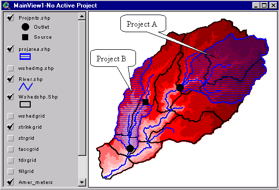
Figure 9. MainView with Two Projects Extracted
|
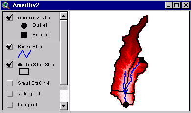
Figure 10. Hydrologic Data for Project B |

Figure 11. Hydrologic Data for Project A |
After the overall hydrologic model is defined in the MainView as shown in , the extracted data for the HMS model is generated and placed in the ProjView, which allows the user to revise the subbasins delineation. Subbasin and routing reach delineations include points where information is needed, i.e., streamflow gage locations, flood damage centers, environmental concerns, and hydrologic and hydraulic controls. The tools allow the user to interactively combine or subdivide subbasins as well as to delineate subbasins to a set of points in a batch manner. The tools are available in the ProjView GUI as shown in Figure 12 and Table 4, Table 5, and Table 6. Typically, the user proceeds from the Basin Processing to the Basin Characteristics to the HMS menus.
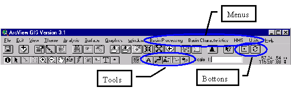
Figure 12. ProjView GUI with GeoHMS Extensions Features Circled
Table 4. ProjView Menus, Buttons, and Tools
|
Menus |
Descriptions |
|

|
This menu provides the user with interactive and batch processing capabilities to modify existing subbasins and delineate new subbasins. There are also several tools available for subdividing basins and preparing batch points for delineation. |
|
|
After the user finalizes the basin delineation, this menu develops the physical characteristics for both the streams and subbasins based on the terrain model. The stream characteristics will be stored in the stream�s attribute table. Similarly, the basin characteristics will be stored in the subbasin�s attribute table. These two tables can be exported for external computations. |
|
|
This menu performs a number of tasks related to HMS. These tasks include default names for the reaches and subbasins, unit conversion, checking and creation of the basin schematic, and HMS files generation. |
|

|
Same as those in the MainView |
Table 5. ProjView Buttons
|
Buttons |
Names |
Descriptions |
|

|
Find Area |
Same as those in the MainView
|
|

|
Toggle |
Same as those in the MainView
|
Table 6. ProjView Tools
|
Tools |
Names |
Descriptions |
|

|
Identify Area |
Same as those in the MainView
|
|

|
Flow Trace |
Same as those in the MainView
|
|

|
Basin Subdivide |
Subdivide existing basin or create new basin at user-specified point
|
|

|
Profile |
Extract the stream profile with elevation based on the terrain model
|
|

|
Batch Point |
Create a batch point shapefiles layer based on the user-specified point
|
|
|
Profile Subdivide |
While the stream profile chart is opened in Figure 13, this tool allows the user to delineate subbasins by pressing the grade break or any point on the profile. |
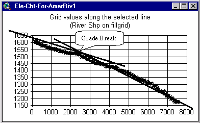
Figure 13. Stream Profile
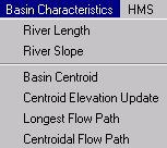
Stream and Watershed Physical Characteristics
When the streams and subbasins delineations have been finalized, HEC-GeoHMS computes several topographic characteristics of streams and watersheds. The stream physical characteristics (such as length, upstream and downstream elevations, and slope) are extracted from the terrain data and stored as attributes in the stream table. Similarly, the subbasin physical characteristics (such as longest flow lengths, centroidal flow lengths, and slopes) are extracted from the terrain data and stored as attributes in the watershed table. The current version of the program focuses on the extraction of physical characteristics instead of hydrologic parameters. The physical characteristics extracted for the streams and subbasins are summarized in Table 7. These physical characteristics tables as shown in Figure 14, Figure 15, Figure 16, and Figure 17 can be exported and used externally to estimate hydrologic parameters. When more experience is gained with applying GIS-generated parameters, it is anticipated that the program will suggest ranges for hydrologic parameters, as appropriate.
Table 7. Physical Characteristics of streams and subbasins
| |
Physical Characteristics |
Attribute Table Heading |
|
Stream
(River.Shp) |
Length
|
Riv_Length |
| |
Upstream elevation |
US_Elv |
| |
Downstream elevation |
DS_Elv |
| |
Slope |
Slp_Endpt |
| |
Stream Profile |
N/A (See Chart) |
|
Watershed
(WaterShd.shp) |
Area
|
Area
|
| |
Centroid Location |
N/A (See WshCentroid.shp) |
| |
Centroid Elevation |
Elevation |
|
Longest Flow Path |
N/A (See LongestFP.shp) |
| |
Longest Flow Length |
Longest_FL |
| |
Upstream elevation |
USElv |
| |
Downstream elevation |
DSElv |
| |
Slope between endpoints |
Slp_Endpt |
| |
Slope between 10% - 85% |
Slp_1085 |
| |
Centroidal Path |
N/A (See CentoidalFP.shp) |
| |
Centroidal Length |
CentroidalFL |

Figure 14. Longest Flow Path and Centroid Location Result
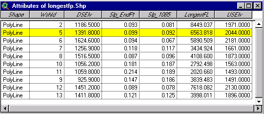
Figure 15. Longest Flow Path Attribute Table

Figure 16. Watershed Attribute Table
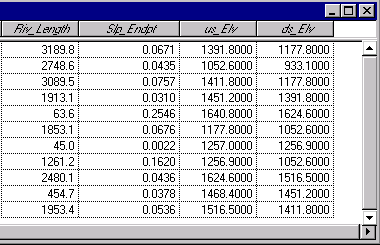
Figure 17. Stream Attribute Table
HEC-HMS Model Files
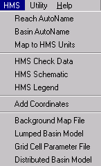
HEC-GeoHMS develops a number of hydrologic inputs for HEC-HMS: background-map file; lumped-basin schematic model file as shown in Figure 18; grid-cell parameter file as shown in Figure 19, Figure 20, and Figure 21; and distributed-basin schematic model file. If the lumped modeling approach is used, then the user can generate the background-map file and the lumped-basin file. If the distributed modeling approach is used, then the user can generate the background-map file, the grid-cell parameter file, and the distributed basin file. The capability includes automatic naming of reaches and subbasins, checking for errors in the basin and stream connectivity, producing HMS schematic, and generating the HMS related input files. The hydrologic data is then entered through HMS menus.
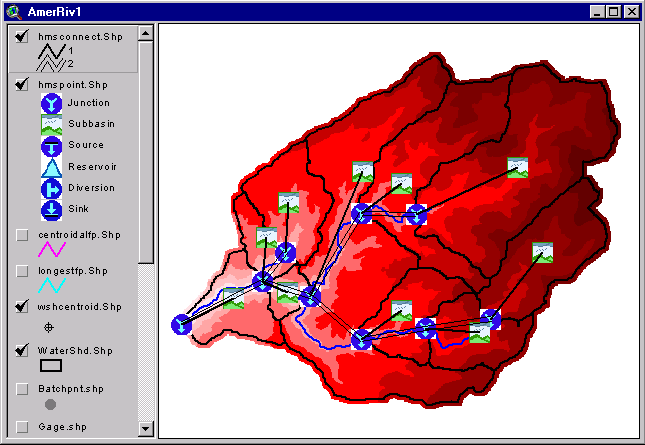
Figure 18. GeoHMS Schematic of the Hydrologic Structure and Connectivity
A separate view is created to overlay the subbasin and the precipitation grid and perform the intersection as shown in Figure 19.
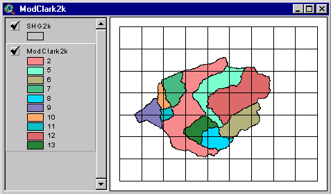
Figure 19. Intersection Between Subbasins and Precipitation Grid

Figure 20. Grid-Cell-Parameter File Result
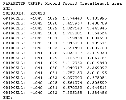
The resulting grid-cell-parameter file in ASCII format looks similar to Figure 21.
|
� Many lines omitted � |
Figure 21. HMS Grid-Cell-Parameter File in ASCII Format
HEC-HMS Application
When the GeoHMS generated files are brought into HMS as shown in Figure 22, the user has a partially completed HMS model as shown in Figure 23. To complete the HMS basin model, hydrologic parameters need to be estimated and entered in HMS. The grid-cell-parameter file and other files are specified in Figure 24. In addition, the user can revise hydrologic elements and their connectivity to reflect difficult modeling areas. Finally, the user needs to develop a Meteorologic Component to represent the precipitation and the Control Specifications Component to define the time window and other time-related specifications. With these three model components completed, the user can refer to the HMS manual to make a simulation run and calibrate the hydrologic model.
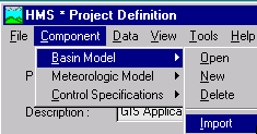
Figure 22. Basin Model Import
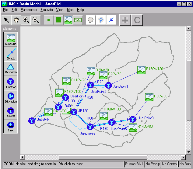
Figure 23. Imported HMS Basin Model
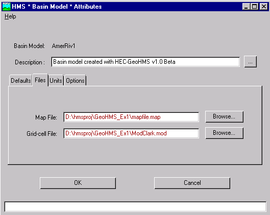
Figure 24. HMS Basin Model Attributes Specifications
Closing Remarks
HEC-GeoHMS implements modern GIS and digital terrain technologies into an effective package to facilitate hydrologic model development. The design and capabilities of the package are based on practical needs of watershed modeling by hydrologic engineers. It does not try to make a GIS expert out of hydrologic engineers, but rather tries to focus the pertinent GIS resources as efficiently as possible on the hydrologic analysis application. Some portions of the digital terrain preprocessing may require more GIS expertise, i.e., transferring coordinate systems and projections, and developing �hydrologically correct� DEMs. It is expected that expert GIS resources will be available to users for those special problems. Also, it may be possible to preprocess areas of interest and provide that database to the hydrologic engineer. As the GIS-hydrology profession advances, preprocessed spatial hydrologic databases (the USGS is working on some aspects of this in the new NED-H project) and standard algorithms for estimating the main hydrologic model parameters will become standard resources. GeoHMS is just the beginning.
References
Hydrologic Engineering Center (2000). Geospatial Hydrologic Modeling Extension (HEC-GeoHMS): User�s Manual. DRAFT. U.S. Army Corps of Engineers, Davis, CA.
Hydrologic Engineering Center (2000). Hydrologic Modeling System (HEC-HMS): User�s Manual. U.S. Army Corps of Engineers, Davis, CA.
Hydrologic Engineering Center (2000). Hydrologic Modeling System (HEC-HMS): Technical Reference Manual. U.S. Army Corps of Engineers, Davis, CA.
Hydrologic Engineering Center (1998). HEC-1 Flood Hydrograph Package: User's Manual. U.S. Army Corps of Engineers, Davis, CA.
Kull, D.W. and A.D. Feldman (1998). "Evolution of Clark�s unit graph method to spatially distributed runoff". J. Hydrologic Engineering, 3(1), 9-19.
Peters, J.C. and D.J.Easton (1996). "Runoff simulation using radar rainfall data". J.AWRA, 32(4), 753-760.
Author Information
|
James H. Doan, P.E.
|
|
Hydraulic Engineer
|
| Hydrologic Engineering Center |
| U.S. Army Corps of Engineers |
| 609 Second Street |
| Davis, CA 95616 |
| Telephone: 530-756-1104 |
| Fax: 530-756-8250 |
|
Email: james.h.doan@usace.army.mil |