Over 1000 miles of alternative route segments were able to be analyzed in ARC/INFO and in ArcView GIS software's GeoProcessing Wizard in an economical manner. Each line segment had one or more possible scenarios - parallel to an existing transmission line; double-circuit an existing line; relocate an existing line to new ROW; adjacent to road, railroad, or pipeline ROWs; or use new ROW - that required different ROW widths on each side of the line segment. Region buffers were created based on the scenarios, which were then intersected with the land cover and wetlands data and analyzed for the number of acres of new or existing ROW. The data was taken into Microsoft Access in order to create summary tables for each route.
A 345-kV transmission line is proposed by Wisconsin Public Service and Minnesota Power between Weston, Wisconsin and Duluth, Minnesota with a 115-kV line extending from Rhinelander, Wisconsin to Tripoli, Wisconsin. Over 1000 miles of alternative route segments were initially considered.
Study Area MapThe route selection process refined the initial segments. Public and agency involvement were key factors in editing the route segments. Public meetings were held in each county within the study area to identify issues and concerns. The principal parties and agencies include
ARC/INFO and ArcView GIS were able to assist this process through easy placement of route segments; providing maps for the public, agencies, and the client; and verifiable data analysis. Maps were produced both as hard copy and in digital form. The latter were provided to the client and posted on their internet site for use by agencies and the public.
The route selection process is still on-going as the public and regulatory agencies review the routes prompting adjustments.
There were several issues to consider in the routing process.
The segments were numbered from Weston to Arrowhead, southeast to northwest. The base number was assigned according to the following:
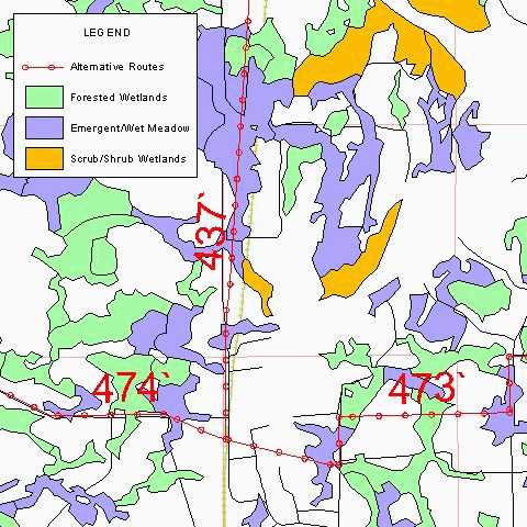
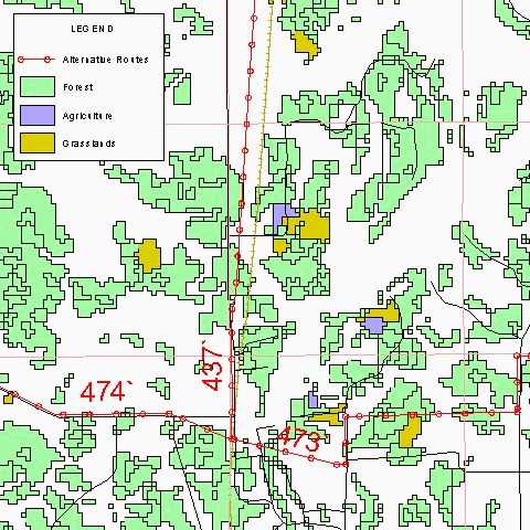
1-199 Weston to Exeland (Northeast corridor)
200-299 Weston to Exeland (Southwest corridor)
300-399 Exeland to Arrowhead
400-499 Rhinelander to Tripoli
Each segment was assigned a unique alphanumerical number that reflected its characteristics:
DEFINITIONS:
a,b,c,d = Subparts of segments
v = 115-kV only
w = 345-kV only
x = Double-circuit
y = Parallel to an existing transmission line, using an H-frame
* = Partially parallel to an existing transmission line
# = A portion of the segment is double-circuit only
' = Segment was adjusted from its original location
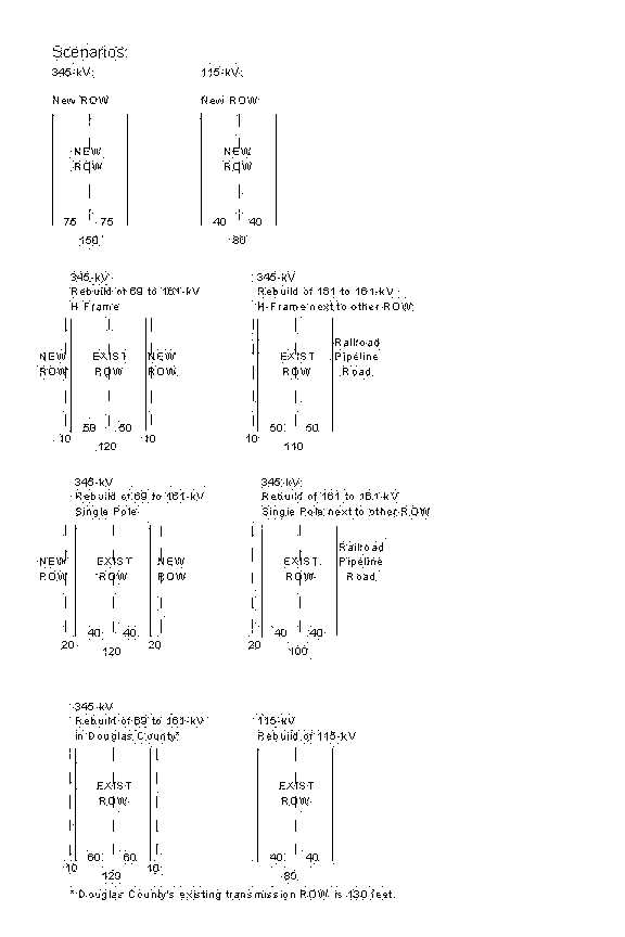
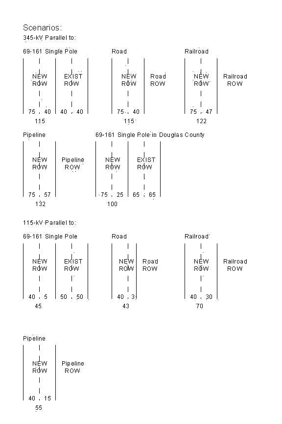
The directionality of each segment was important since buffers would be created that could potentially have different distances on the left and right sides of the line. The segments were in the direction from Weston to Arrowhead and Rhinelander to Tripoli. Items/fields were added to each line to indicate the width of ROW on each side and if the ROW would be in a existing ROW or if it would be new ROW. If segments had both new and existing ROW this also would be indicated with items in the attribute table. If a line could be either parallel or rebuild then these segments were put into separate coverages. The rebuild segments were placed on top of the existing transmission lines shown on the digital quads. The ROW widths were calculated based upon the following scenarios.
Once each segment was populated with the correct ROW widths the route segments were ready for analysis. Three basic types of analyses were performed. The first was length, which included total segment length and length through various constraints such as wetlands and land cover. The second was counts, such as house and stream counts. The third was area, such as new and existing ROW acreage, wetland acres, and land cover acres. The following variables were quantified.
VARIABLEThe data tables were exported from ArcView as dBase tables and taken into Access where the segments could be combined into different route combinations and data totalled for each of the variables listed above. The data was submitted to the PSCW as part of the application for the project. Paper maps of the route segments were also provided to show the location of the segments for the agencies and at public meetings. A digital version of the maps has been posted on the WPS web site and is being used by the PSCW in their Environmental Impact Statement.
This transmission line routing study was a major project covering a large area with numerous alternatives. Over 300 individual segments were edited and populated with attributes. Without the use of ARC/INFO and ArcView the data would not be as readily verifiable and accessible to the permitting agencies and the public. Each edit of the route segments and tables were kept in order to document the changes. The routes at this time are still being modified.