Ricardo Cuberos Mejía, MSc. Arch., MCSE
Nelly Caldera de Ugarte, MSc.Tourism
Nixon Molina, Geographer
José Indriago, MSc. Arch.
In 1997, the Research Institute of Faculty of Architecture and Design, University of Zulia, started the R&D project of a decision making support system for tourism planning. For this, GIS technologies have been used for geocodification and spatial analysis of all the tourism facilities and resources existing in Zulia State, studying this kind of socioeconomic development according to critical poverty problems that are typical of their population. This paper describes this geographic information system, with the application of accessibility analysis, areas of influence, and three-dimensional studies through network analysis--three-dimensional analysis with ArcView GIS clients, ArcExplorer clients, and MapObjects clients, on an MS Windows NT client/server environment.
Tourism activity means a highly complex of relations between factors that happens in the city. As urban planning activity, ordering the tourism system implies the management of a lot of information related to the cultural, social and economic context of each reality, and potential relations due to proximity or another location factors. Organizing and automating this amount of spatial data through GIS technology facilitates to planners, official employees and general public to use it in order to planning, development and marketing of tourism activity.
Maracaibo is almost 2 million persons city, located in front to the second biggest lake on South America. It's the capital city of Zulia State, at the western area of Venezuela. This region, with 43 thousand square kilometers and 1.140 kilometers of coast, contains a lot of potential places for tourism activity that, associated to the oil production, stockbreeding and farming, are supporting social-economic regional development.
Use of GIS technology for tourism planning offers a group of advantages in data documentation and processing (Caldera-Reyes, 1999):
These advantages help in the simplification of processing of voluminous geographic-tourist information, referred to natural and cultural resources, tourist facilities, accessibility, transport, land uses among others. Also, they can drive spatial analyses necessary to generate thematic maps or statistical reports, as much for academic, institutional, enterprise interest as for own tourists requirements.
Starting on 1997, the ToURism Planning Geographic Information System (SIGTUR, abbreviation in Spanish) was born as a research program created by 6 professors from the Faculty of Architecture and Design Research Institute (IFA) and the Postgraduate Studies Division (DPG) on University of Zulia (LUZ). With a initial financing from Human and Scientist Development Council (CONDES-LUZ), this program begun with the development of two projects: the first one, to establish the structure of subsystems according the tourism planning knowledge field; and the second one, to generate the information system platform for documentation and analysis processes. Both projects took Maracaibo city as initial study case, but the ultimate goal is the creation of tourism GIS for whole Zulia State.
Gradually, other institutions were associating to the project. Mayoralty of Maracaibo City, Regional Office of Urban Development National Secretary and Zulia Tourism Corporation, gave their support giving information and facilitating employees hours for collecting and structuring activities. Assistance to technical congress and advertising the research trough professional meetings and press reviews, helped to give viability to the implantation of the system proposed. Esri University LAB KIT Agreement, signed between Esri, LUZ and AT SISTEMAS as local distributor on January 1996, supported software acquisition and technical consultancy.
Past December, first phase of research program concluded and now it's in renovation time, improving consulting systems with postgraduate students helping and preparing new information groups about Maracaibo city also other main cities on Zulia State.
Preliminary studies about the different factors that participate on tourism planning converged on the proposal of a Theoretical - Methodologyc Referential Model, which included fifteen variable subsystems. These subsystems were oriented to the sustainable spatial ordering of tourism activities, involving contextual consideration as income groups or natural restriction to construction. I order to the structural analysis of tourism according to an integral planning accessible, research team determined two groups of variables:
1. Variables that functionally delimitate tourism space:
2. Variables that qualify tourism space:
All this group of variables plays with different weight in tourism planning analysis, in order to answer two groups of questions estimated to resolve for the final user of the system. Table 1 and 2 show preliminary resolve intention of SIGTUR.
Table 1: ESTIMATED QUESTIONS FROM SIGTUR'S TOURIST USER |
|
| Source: Caldera & Reyes, 1999; Research Program SIGTUR-ZULIA, 1996-2000.CONDES -LUZ |
Table 2: ESTIMATED QUESTIONS FROM SIGTUR'S RESEARCHERS |
|
| Source: Caldera & Reyes, 1999; Research Program SIGTUR-ZULIA, 1996-2000.CONDES -LUZ |
SIGTUR is based on three kind of process, combining automated commands and know-how operators knowledge:
1. Documentation. This process feeds GIS system with graphical and attributive information.
2. Analysis. It use GIS capacities to calculate relation phenomena between urban variables.
3. Results. It search the delimitation and qualification of potential tourism sites.
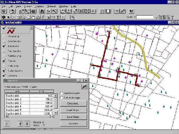
Figure 1: Accesibility analysis to tourist attractions, applying Network Analyst extension over Road structure
There is a close relation between the different kind of users preliminary served by SIGTUR, and access interface to data :
For both cases, system structured two kinds of data access:
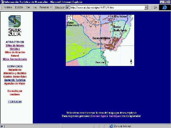
Public access implies a restricted use to data, only for its partial visualization according to pre-selected questions. It works as a server-based environment, where clients receive certain outputs through menu selections. Here, users can not manage directly whole groups of data. This access is possible by Internet or Extranet connection to SIGTUR servers, according access level of users and their institutions. It uses a generic Internet browser like Navigator 4 or IE4 (figure 2), or a map-based browser like Esri ArcExplorer. It generate basically single thematic maps with referential information.
Figure 2: Map access to attractive building, surfing by city maps through Internet Information Server Web site.
Local access consists to create complex queries, update o generate new data, o create information subsystems about specific data field. It works in a client-server environment, where SIGTUR server supply geo-referenced database to workstations through intranets, and support development of data analysis interface on smart client stations. For this, SIGTUR use Esri ArcView GIS workstations, any of them with Network Analyst extension and other with 3dAnalyst extension, to create complex thematic maps with concentration or accessibility analysis (Figure 3). Other one uses Esri ArcExplorer to save AEP projects as support to consulting o urban research activities.
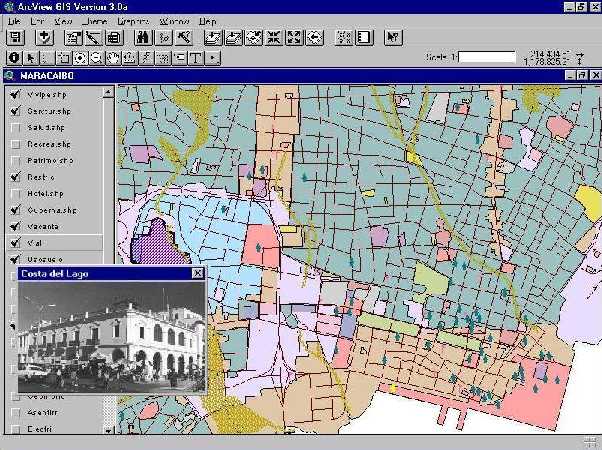
Figure 3: Thematic map combining land uses with tourist services, on Esri ArcView GIS platform with graphic hot links.
SIGTUR was created initially as a Data Mart project, thinking in a Corporative Data
Warehousing about urban information of Maracaibo city initially, and Zulia State later. Authors' Institution, Faculty of
Architecture and Design Research Institute, has developed a lot of urban studies about
Maracaibo city and Maracaibo Lake Basin, from three Urban Development Plans in the '90s, to urban improvement
proposals on special interest areas. Due to Tourism is an activity that collaborate with
development of cities and territories, it needs a lot of common urban variables with other
human activities and natural consideration; for that, SIGTUR is belonging to a
cross-related data storage that supply information to specific thematic projects and that
let to considerate them respect to the other studies of the city life.
For these considerations, SIGTUR Data Mart is physically located on three Intel-based
servers, conceived under MS Windows NT 4.0 environment with partial replication services
and supported by Internet Information Server 4.0 (IIS) and MS SQL Server 7.0. With a
user-level security developed on a research data domain, and MS Proxy2.0 firewall to
manage dynamic IP configuration on a isolated network frame, data is protected from
inbound intruders and undesirable local accesses.
Data storage is structured according three criteria's:
Network clients can be:
Figure 4: Concentration map of historic sites, compared with vicinity areas classified by income group, Esri ArcExplorer client on MS WinNT server-client environment.
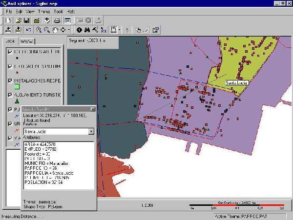
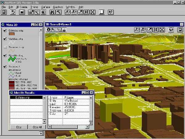
Figure 5: View point analysis on downtown, applying 3D Analyst extension to show topography and panoramic views.
A fifth kind of client is being created, through Esri MapObjects controls on ActiveX complement, which process data from a trial Internet Map Server prototype. This work is being developed through two master degree students on Informatics Applied to Architectural Design. Also, SIGTUR is attending any non-Esri clients, as MapInfo Pro 4.0, ITC Ilwis 3.0, and a non-Windows platform (MacOS 8 or above), due to the current diversity of computers and system requirements on our Institute and in the other related regional institutions.
This project is generating sooner its first results. Conformation of colaborative thematic information networks, within already it has been included our institution, will allow to handle consistent data closely linked with social realities on our region, where poverty reaches excessive limits and where tourism must arise simultaneously to processes of urban improvement.
The leadership that our institute has obtained at local level grants us a triple commitment, not only like solution provider for our institutional surroundings, or like human resources trainer at bachelor and graduate level, but even like booster of technological changes that public university must to promote for integral development of Venezuelan Country.
Authors acknowledge primarilly to Janeth Cestary and Leriz Camacaro by their enforcement on development of this research program. Also, we want to express our gratitude to the CONDES, FADLUZ and IFA authorities, for the continuous support to develop this work. Our comradeship with the other researchers that are working with GIS technologies and that colaborate interchanging urban data with us. Finally, we emphasize Esri support through AT sistemas as local distributor, reiterating our interest to renew and to expand our current academic agreements to produce better and more powerful products.
Ricardo Cuberos Mejía
Information System Researches Manager
Teaching Professor on Telematics and Computer Aided Design
Faculty of Architecture and Design Research Institute
University of Zulia - Maracaibo, VENEZUELA
E-mail: rcuberos@luz.ve