EnerQuest Systems, LLC in conjunctions with Bohannon Huston, Inc. and Tetra Tech NUS, Inc. is currently performing a large-scale digital terrain-mapping project of Bernalillo County, New Mexico. This project is being conducted for a consortium of federal, state, county and municipal agencies that includes: the U.S. Army Corps of Engineers, Bernalillo County, the NM State Highway Department, City of Albuquerque, Middle Rio Grande Conservancy District and AMAFCA. Digital mapping products include the delivery of over 1000 1 ft gsd color digital orthophotos and 1010 sq. miles of 1 ft & 2 ft contour data. All contours are being derived from 1 meter & 3 meter gsd photometrically enhanced airborne LIDAR data flown by Aerotec and EnerQuest Systems, LLC. Project data will be used by the various agencies for flood control, irrigation, planimetric, terrain mapping and for planning purposes.
Approximately 2 terabytes of LIDAR and aerial photographic data were collected and generated for this project. EnerQuest Systems, LLC has developed new techniques that allow for faster more cost effective methods of processing & producing digital surface and orthophotographic products. This was accomplished using GIS, CAD, photogrammetric, image processing and remote sensing techniques. Newly applied technologies include the integrated use of airborne GPS and IMU technology, digital color scanning, Fast Fourier Filtering techniques used in the removal of vegetation & buildings from LIDAR data, and for the color balancing of digital orthophotography (removal of solar and camera radiometric shading effects. Esri products played a crucial role in project & data management, LIDAR processing and editing, the building of 3-D terrain models, and in the QA/QC process. The software used in this project includes ArcView (Spatial and 3-D Analyst), Workstation Arc/Info NT, ERDAS Imagine, Intergraph Softcopy, Bentley MicroStation and proprietary software developed by EnerQuest personnel. EnerQuest Systems, LLC has subsequently produced an ArcView/Avenue/C++ based LIDAR processing system called LIDAR Analyst. The most prominent feature of LIDAR Analyst is its ability to import, process and export RAMSTM (Remote Airborne Mapping System) Lidar data within the ArcView software environment. Users can import and view the collected Lidar flightline boundaries as ArcView shapefiles, and create Lidar images that are automatically edge-matched. Lidar Analyst functionality includes the creation of bare earth terrain models, generated using automated Fast Fourier filtering, Multiple Return Analysis and Knowledge Based processing techniques.
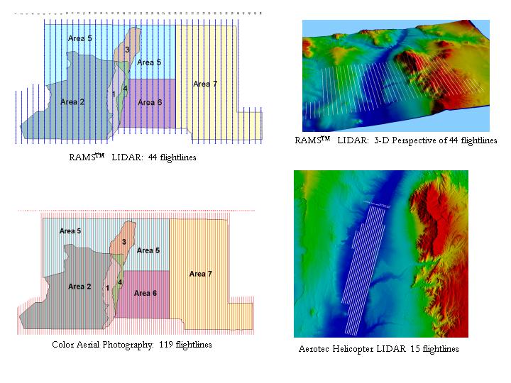
EnerQuest Systems, LLC in conjunction with Bohannon Huston, Inc. and Tetra Tech NUS, Inc. is currently conducting a countywide digital terrain-mapping project of Bernalillo County, New Mexico. This project is being conducted for a consortium of agencies that includes: the U.S. Army Corps of Engineers, Bernalillo County, New Mexico State Highway Department, City of Albuquerque, Middle Rio Grande Conservancy District [MRGCD] and the Albuquerque Metropolitan Arroyo Flood Control Authority [AMAFCA]. Project data acquisition included the capture of 1010 sq. miles of color aerial photography and airborne digital LIDAR (Light Detection and Ranging) data. Deliverables include the generation of over one thousand 1ft gsd digital color orthophotographs and 1010 sq. miles of 1ft & 2ft contour data. Over 2 terabytes of orthophotographic and digital LIDAR data were generated for this project, with all topographic information being generated from 1 meter & 3 meter gsd LIDAR data flown and capture by Aerotec and EnerQuest Systems, LLC. The project study area was divided into 7 subareas, with 44 color aerial photographic and 134 LIDAR flightlines being flown in order to obtain full coverage of Bernalillo County, (figure 1.).
In order to process such large amounts of data EnerQuest has develop a faster more cost effective production process for generating digital terrain models and orthophotographic products. This process uses commercially available off the shelf [COTS] and in-house developed software. This methodology includes the implementation of several advanced level technologies and processes that include: -Remote Airborne Mapping Systems [RAMSTM] LIDAR and Digital Camera system -Airborne Global Positioning System [GPS] and Inertial Measurement Unit [IMU] hardware systems -RAMSTM suite of GPS, IMU and LIDAR processing software -Very High Resolution photogrammetric digital scanning techniques -Fast Fourier Transform [FFT] filtering techniques -Used in the removal of vegetation & buildings from LIDAR data -Used for the color balancing of digital orthophotography (in the removal of solar and camera radiometric shading effects).
In this project LIDAR data was primarily used for the creation of bare earth surfaces, used to generate digital orthophotos and the 1ft & 2ft contour data. Various software systems were initially used to process this data, including ArcView (Spatial and 3-D Analyst), Workstation Arc/Info NT, ERDAS Imagine, Intergraph Softcopy, and the Bentley MicroStation software system. In order to meet production needs, EnerQuest has produced it own set of software products for the processing of RAMSTM generated GPS, IMU and LIDAR data. This includes the RAMSGPS, RAMSProc, RAMSPOS, POSEO and the LIDAR Analyst software systems. These software modules allow the user to perform much of the same processing functions as the initially used COTS, within a very user-friendly windows environment and with expanded customized functionality. Esri products have played a crucial role in all aspects of this project from flight planning, project & data management, LIDAR processing and editing, the building of 3-D terrain models, software development and in the QA/QC process.
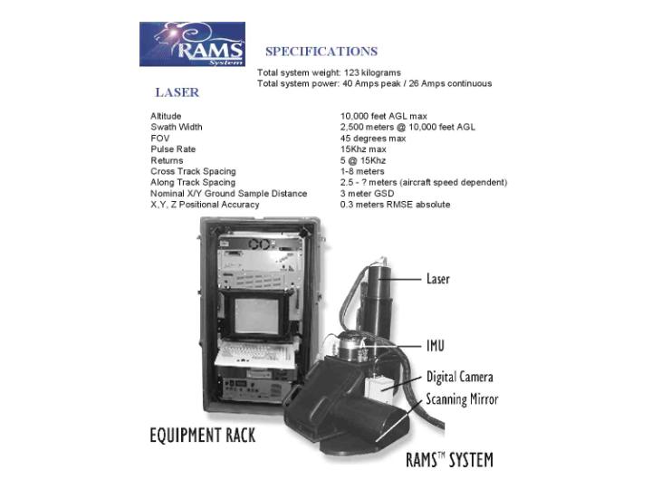
Most of the LIDAR data acquired during this project was captured by EnerQuest’s RAMSTM LIDAR systems and integrated with very high resolution helicopter derived LIDAR data acquired by Aerotec. The RAMSTM LIDAR system consists of an optical bench which includes a telescope, rotating mirror and Near IR laser that operates with a maximum pulse frequency rate of 15KHz. This system has the capability to detect 5 return laser pulses, (figure 2.). The systems maintains a field of view [FOV] of 45 degrees, a nominal x,y ground sample distance of 3 meters and an absolute x,y,z positional accuracy of 0.3 meters RMSE. Other critical components include an airborne GPS and IMU that maintain post-processing roll-pitch accuracy of 20 arc seconds and a heading accuracy of 30 arc seconds. This corresponds to an absolute (x,y) accuracy of 30 cm, and an absolute (z) accuracy of 15 cm.
Project specifications included the following tasks and standards: -Acquisition of 1-meter GSD laser data acquired for the generation of 1-foot contour areas -Captured from a helicopter platform – 7cm absolute accuracy -Acquisition of 1:5,000 conventional black & white photography -Use of Airborne GPS/IMU systems -Used as QC for 1-meter laser data -Acquisition of 3m GSD laser data acquired for the generation of 2-foot contour areas -Captured from a fixed wing aircraft – 10cm absolute -Acquisition of 1:12,000 natural color aerial photography for entire project area -Use of Airborne GPS/IMU -Used as QC for 3m laser data -Creation of Digital color orthophotos from color aerial photography -All products must meet ASPRS Class 1 Standards -RMSE of all well-defined points 1/3 ft contour interval -1ft color digital orthophotos RMSE 2ft x or y Project deliverables included the following aerial photographic and LIDAR derived products: -2 foot contours -Intergraph .DGN format -Esri Arc/Info coverages -AutoCAD .DWG drawing files -DTM files in 5k x 5k foot tiles -New Mexico Stateplane coordinates Spheroid GRS1980, Datum NAD83, units feet. -(Intergraph TTN, Esri TIN, and Softdesk formats) -1 foot Color Digital Orthophotos -TIFF, Mr. SID compressed and RGB format (5k x 5k foot tiles) -Color balanced & mosaicked Digital Orthophotos -Seamless edge matches
They above mentioned deliverables give the client a high-resolution countywide dataset that includes: color digital orthophotography; digital terrain data consisting of 1 and 2 ft contours, and associated digital terrain models in an Intergraph and Esri TIN format. Project data will be used by the consortium agencies for flood control, irrigation, planimetric, digital terrain mapping and for planning purposes. These products represent the highest wide area resolution terrain data available for the Middle Rio Grande area, (figures 3 and 4).
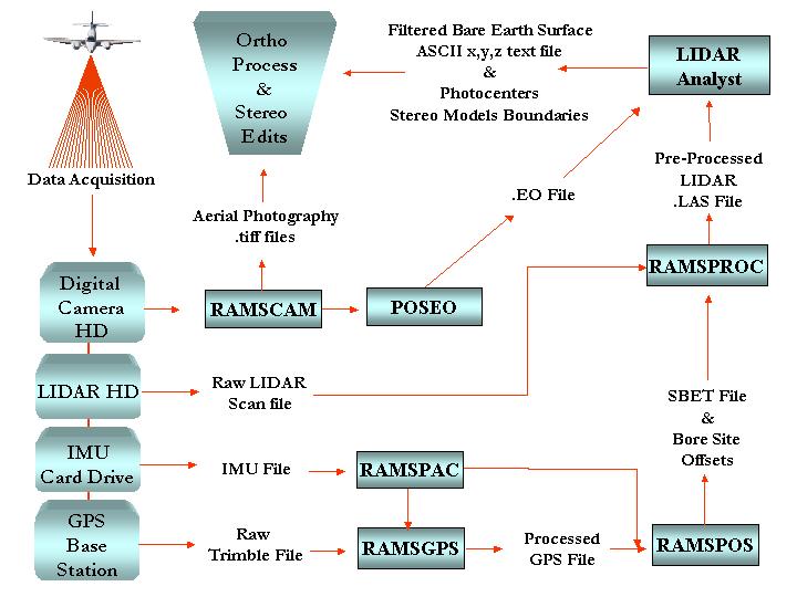
Due to the large amount of collected project imagery and LIDAR data, EnerQuest has developed a production methodology that was initially implemented using COTS software. As the project progressed, the production process was enhanced by using in-house developed software. This has lead to the development of the RAMSTM suite of software, which has become EnerQuest’s core tool for present and future digital camera and LIDAR data processing. Data processing for the RAMSTM system can be immediately initiated once the acquisition phase has been completed. Removable hard drives that store the acquired data are transferred from the system on the aircraft, and downloaded to data processing workstation(s) at EnerQuest’s facilities. Processing can then begin using the RAMSTM suite of software, which includes the following modules: -RAMSCAM: Used to collect and pre-process digital camera imagery -RAMSPAC: Processes raw IMU data -RAMSGPS: Processes raw GPS data -POSEO: Generates a poseo file that contains image photocenters and their associated descriptive and numeric attributes -RAMSPROC: Integrates processed IMU and GPS data to create an SBET file -LIDAR Analyst: processes and filters raw lidar data in order to generate a bare earth surface. The process flow describe below is essentially the methodology used during the Bernalillo project, with the exception that the color imagery was acquired using traditional means (color film acquisition), and was later digitally scanned using a photogrammetric quality scanner. Data processing begins as follows (figure 5): 1. Simultaneous in-flight acquisition of digital imagery, LIDAR data, IMU and GPS information. Each dataset is recorded and stored separately on it own hard drive using an on-board removable disk array. 2. Once acquisition has been completed the removable hard drives are transferred to data processing workstation(s) on which all pre and post data processing occurs. 3. Using RAMSPAC raw IMU data is processed in order to extract viable roll-pitch and heading correction information. Raw GPS data is processed using RAMSGPS, generating a file that contains highly accurate x,y,z locations. 4. The processed IMU and GPS data is then inserted into RAMSPOS, which is used to generate an SBET file. 5. The SBET file, raw LIDAR data and boresite-offset coefficients are then input into RAMSPROC. RAMSPROC generates an IMU/GPS corrected LIDAR points file (file_name.las) in the established project coordinates. 6. The POSEO program generates an ASCII text file that contains the photocenters for the collected digital imagery. 7. The .las file is then input into LIDAR Analyst, where it is filtered using Fast Fourier Transform [FFT] techniques. The filtering process is used for the removal of vegetation and cultural features. The result is a bare earth surface which can be exported as an ASCII text file containing filtered x,y,z LIDAR points. 8. The processed LIDAR ASCII text file is imported into the Intergraph software environment, where final surface edits are performed. The LIDAR generated surface is used in the creation of the digital orthophoto quadrangles. 9. Creation of digital orthophoto quadrangles using the Intergraph OrthoPro and Image Station software.
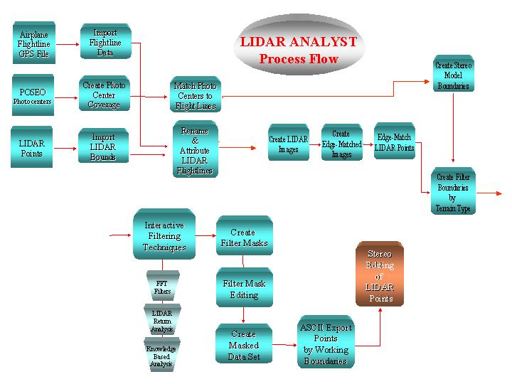
The RAMSTM and Aerotec LIDAR systems generate a highly accurate and dense coverage of x,y,z point data. In order to achieve the project objectives, (generation of 1 & 2ft contours and a Digital Terrain Model [DTM] of Bernalillo County), all vegetation and cultural features must be removed from the data. Traditionally this is accomplished using filters that generally smooth and alter the original data values, or by time consuming manual editing techniques. EnerQuest Systems has subsequently produced an ArcView/Avenue/C++ based LIDAR processing software system called LIDAR Analyst. LIDAR Analyst contains a series of filtering techniques that identify, attribute and remove only non-bare earth surface point data. These Fast Fourier Transform [FFT] based filtering techniques generate a mask that is used to identify and remove lidar points representative of vegetation and cultural features. These techniques preserves the original x,y positions and elevation values of the LIDAR data set, within an automated environment. The most prominent feature of LIDAR Analyst is its ability to import and process flight planning and lidar data within the ArcView environment. Users can view and query data in an image and ArcView shapefile format. Users can create Lidar images by flight lines and edge-match them automatically. Automated filter and masking processes are quick and simple to perform using advanced-level image processing techniques. These techniques generate bare earth terrain models in an ASCII file format that can be imported into terrain analysis packages such as Arc/Info, ArcView Spatial Analyst/3-D Analyst, Intergraph, AutoCad and ERDAS Imagine, (figure 6.).
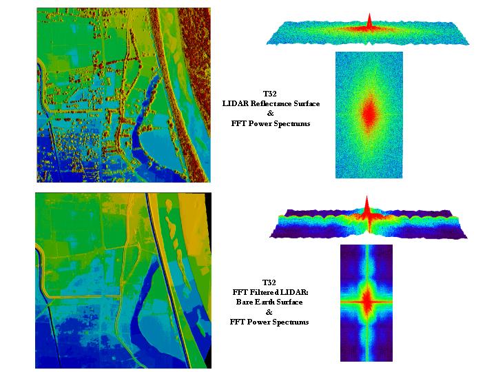
LIDAR ANALYST’s base functionality is centered on the following processing methodology and data handling structure: -LIDAR Project and Data Management -Geographic Information System Framework -Fast Fourier Filtering Techniques -Lidar Multiple Return Analysis -Knowledge-based Terrain Analysis -3-D Cross Sectional Analysis LIDAR ANALYST provides a number of automated features for the processing data within a production environment. This is an important feature due to the large amounts of data generated during the data capture process. -Automatic capabilities for importing Lidar flightline boundaries from flight data. -Automated means for performing Lidar image edge matching along flightline boundaries -Automated means for creating Digital Terrain Models (DTM). -Automatic means for developing filtered bare earth surfaces and DTMs.. -Automated means for exporting user-specified regions of raw, filtered, and multiple return Lidar data as an ASCII formatted textfile. Most of the currently processed Lidar data of Bernalillo County was converted using FFT based filters, which work in Urban and vegetated areas with densities of 50 - 60%, (figure 7.).
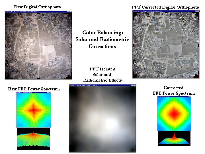
The DTMs generated from the LIDAR data also serves as the surface model used to generate Digital Orthophoto quadrangles. In the Bernalillo project over 1000 high-resolution digital orthophotos will be created. The orthos are gridded into 5000 x 5000 ft tiles. Each tile is color balanced and corrected for solar and radiometric shading effects using FFT filtering techniques, (figure 8).
To date over 400 square miles of Bernalillo County data have been delivered to the client. This includes both digital orthophotography and its associated LIDAR generated DTM surface and contour data. All 100 square miles of 1 ft contour interval data has been delivered and checked by the client. All project data standards have been meet or exceeded for these deliverables, including the 0.3 foot RMSE accuracy (ASPRS Class 1) for delivered LIDAR data, and the 2.0 foot x,y accuracy for all digital orthophotos. EnerQuest Systems LLC has developed an efficient and automated methodology and software for the processing of RAMS derived LIDAR and digital camera data. This includes the RAMS suite of software that is used to process Digital Camera, GPS & IMU and LIDAR derived data.