Thomas A. Evans and Cameron T. Ackerman
Abstract
HEC-GeoRAS is a suite of GIS pre- and post-processing tools for HEC-RAS, a one-dimensional river hydraulics model developed by the Hydrologic Engineering Center (US Army Corps of Engineers) and widely used in Civil Engineering practice. GeoRAS allows hydraulic engineers to use ArcView or ArcInfo to develop HEC-RAS models integrated with digital terrain models and other GIS data sets. Version 1.0 of GeoRAS was released by HEC as a set of ArcInfo macros. A similar product, called AVRAS, was developed in ArcView by Esri staff. HEC-GeoRAS version 3.0 is an ArcView extension, developed jointly by Esri and HEC, and distributed by HEC. It provides the same pre- and post-processing functions as its predecessors, and extends them to take advantage of new data import and export features in HEC-RAS version 3.0. These new features include visualizing velocity distribution results in GIS, and extending the model development tools to include hydraulic surface characteristics (Manning's n).
HEC-GeoRAS is an ArcView GIS extension that prepares geospatial data for use with the Hydrologic Engineering Center River Analysis System (HEC-RAS) and presents HEC-RAS results in a geospatial context. The extension allows users with limited GIS experience to create an HEC-RAS import file containing river geometry and model parameters from an existing digital terrain model (DTM) and shapefiles that define the stream network, cross-section locations and other hydraulic characteristics of the river system. After a hydraulic analysis is completed in HEC-RAS, HEC-GeoRAS can develop and display themes of inundated area, water depth and water velocities from the results of that analysis.
Version 3.0 of HEC-GeoRAS is based on version 2.2 of AVRAS, which was developed by Dean Djokic at Esri with technical support from HEC staff. AVRAS will now be discontinued, and HEC-GeoRAS will be an official product of HEC. It will be available on the HEC web site with complete documentation, and available with technical support, like other HEC products, from HEC vendors that choose to distribute and support it.
Beyond implementing HEC-GeoRAS in ArcView, version 3.0 has additional features to take advantage of data transfer capabilities added to HEC-RAS at version 3.0. These features include the ability to import roughness values as part of cross-section geometry, to export bank stations on cross sections, and to export velocity estimates at points on cross sections as well as water surface elevation values on the cross section.
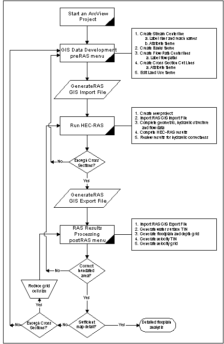
Version 3.0 of HEC-GeoRAS (HEC, 2000b) preserves the pre- and post-processing strategy from earlier versions of AVRAS and GeoRAS (Ackerman, et al, 1999). The interaction between HEC-GeoRAS and HEC-RAS (HEC, 2000a) has not changed. GeoRAS creates an import file for RAS from a digital terrain model in the form of an ArcView (or ArcInfo) TIN and a series of shapefiles defining features in the model. RAS reads the import file and generates an incomplete model geometry. The user must then complete the model geometry-most importantly adding hydraulic structure data-and supply flows and boundary conditions for all the flow profiles to be calculated by RAS. Once the hydraulic calculations are completed in RAS, the user can export the results, and use GeoRAS to generate grids and shapefiles to represent depths, velocities, and inundated areas corresponding to the calculated flow profiles. Figure 1.
Figure 1: GeoRAS Process Overview
Developing HEC-RAS Model Geometry with HEC-GeoRAS
To construct the geometry of an HEC-RAS river model, GeoRAS requires the user to provide a TIN to represent the land surface and shapefiles to represent the stream network and the plan-view locations (cutlines) of the cross sections to be used in the model. In addition, the user can optionally provide shapefiles representing the locations of the stream banks, and in-channel and overbank flow paths. A new feature also allows the user to provide a polygon shapefile containing land surface categories, from which roughness values (Manning's n) values will be extracted and attached to the cross sections.
The following themes can be used to develop HEC-RAS geometry using HEC-GeoRAS.
Developing a hydraulic model begins with an accurate geometric description of the surrounding landform, especially the channel geometry. Channel geometry normally dictates flow in river systems. Only DTMs describing channel geometry with high accuracy and resolution should be considered for the basis of performing hydraulic analysis. Further, all themes used in developing a RAS model should be created and edited with thoughtful evaluation of the river hydraulics as governed by the terrain. It is crucial to the validity of the resulting HEC-RAS model that the river network, flow paths, bank positions, and cross-section locations be consistent with the terrain model.
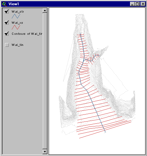
Figure 2: Elevation Contours, Cross Sections, and Stream Network in ArcView
Data imported to HEC-RAS from HEC-GeoRAS keeps its 2D and 3D coordinates, so that a georeferenced model in HEC-RAS has a more map-like appearance than a non-georeferenced schematic. The coordinates preserved in HEC-RAS permit results from hydraulic simulations to be mapped in HEC-GeoRAS and incorporated into other GIS projects. Figure 2 and Figure 3 show the same geometry in ArcView and HEC-RAS.
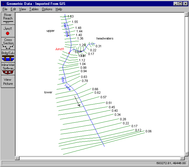
Figure 3: Model Geometry Imported to HEC-RAS
Mapping HEC-RAS Results with HEC-GeoRAS
HEC-RAS model results can be exported to a file to be read by HEC-GeoRAS. The file will have a .gis extension, and contains the locations of the cross section cut lines, the stream centerlines, and, optionally, the ground points along the cross sections. Water surface elevations for all exported profiles are grouped with the cross-section cut lines, along with bounding polygons of the modeled regions for each profile. Refer to the HEC-RAS and HEC-GeoRAS manuals (HEC, 2000a; HEC, 2000b) for details on the meaning and importance of the bounding polygons. Version 3.0 of HEC-RAS can also export water velocities at points along the cross sections, and the locations of the bank stations on the cross sections.
HEC-GeoRAS performs no hydraulic calculations. The results from HEC-RAS are visualized through the following sequence of steps.
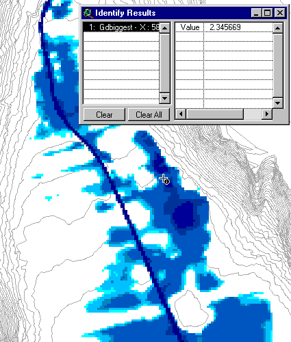
Figure 4: Depth Grid with Terrain Elevation Contours
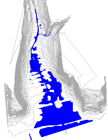
Figure 5: Inundation Boundaries as Polygon Shapefile
Since GeoRAS's interpretation of RAS results is based entirely on geometry, and not on hydraulics, users are cautioned to check the depth and inundation boundary results carefully. A hydraulic model lacking a sufficient number of cross sections to define bends in the channel will produce poor mapping results outside the immediate vicinity of the cross sections. Users should regard the grids and shapefiles generated by GeoRAS as a good start to a flood map, but must be willing to apply their own judgement and understanding of hydraulics to areas distant from cross sections, or to areas shown as inundated, but not hydraulically connected to the river channel. Several such isolated areas are visible in Figure 5. Such anomalies that the user decides are not representative of the hydraulics of the area should be edited using the tools native to ArcView.
Version 3.0 of HEC-GeoRAS brings several new features to the earlier versions of GeoRAS and AVRAS. Most importantly, the program supercedes AVRAS as the ArcView tool for preparing HEC-RAS models and visualizing their results. In addition, several new features are implemented to support new import and export capabilities in HEC-RAS version 3.0. These features are:
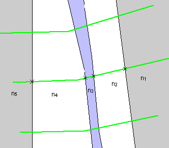
Figure 6: Land Cover Classifications and n Values on Cross Sections
HEC-RAS at version 3.0 can export cross section bank stations and estimated velocities on cross sections. These positions and velocities are known to HEC-RAS only at the cross sections, so interpretation between the cross sections is performed by GeoRAS by simple geometric extensions. In the case of the bank stations, bank lines are approximated by straight lines from the bank positions on one cross section to the next.
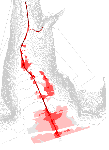
Figure 7: Visualization of Velocity Results from HEC-RAS
Velocity results are more complicated. Water velocities may vary a great deal in between cross sections depending on the changing shape of the channel. GeoRAS uses velocity points on the cross sections as mass points to establish water velocities, and uses the cross sections themselves as breaklines to create a water velocity TIN. The program then sets water velocities to zero in cells with water depth values of zero to eliminate one obvious type of error in interpolation. This method works reasonably well where the hydraulic model has densely located cross sections and a gradually varying channel shape. However velocity values used for visualization must be carefully scrutinized and treated with increasing skepticism as they get farther from the cross section. The greatest value of this data visualization method may be as a model diagnostic. Implausible velocity distributions may indicate flaws in the hydraulic model, or that available channel data is not adequately refined to support velocity distribution calculations.
Ackerman, Cameron T., Thomas A. Evans, Gary W. Brunner (1999). "HEC-GeoRAS: Linking GIS to Hydraulic Analysis Using ARC/INFO and HEC-RAS," 1999 International Esri User Conference, Esri, Redlands, CA.
Hydrologic Engineering Center (2000a). HEC-RAS (Version 3.0), River Analysis System, User=s Manual, U.S. Army Corps of Engineers, Davis, CA.
Hydrologic Engineering Center (2000b). HEC-GeoRAS (Version 3.0), An extension for support of HEC-RAS using ArcView, User=s Manual, U.S. Army Corps of Engineers, Davis, CA.
Author Information
Senior Hydraulic Engineer
US Army Corps of Engineers
Hydrologic Engineering Center
609 Second Street
Davis, CA 95616
Hydraulic Engineer
US Army Corps of Engineers
Hydrologic Engineering Center
609 Second Street
Davis, CA 95616