Policy makers (such as Communicable Disease Control and Prevention (CDC), local health offices, or program coordinators) request printed maps for reports that are then given to selected health officials as a measure of change. Problems arise when the data is not in a usable format, the analysis lacks epidemiological methodology; the part-time user lacks familiarity with the GIS program or has specialized needs, or the time dependencies of data encumbers the process for fulfilling the needs. The creation of useful maps can be slow and laborious for everyone involved, leaving health managers and related organizations without direct access to the spatially enabled data. The MapDesigner model resolves many of these problems through a multi-layered GIS architecture that integrates desktop and Internet mapping along with simplifying the process and redistributing the roles of map and data creator. MapDesigner bridges the chasm between spatially enabled health care data and health managers/specialists who can best make the decisions required for proper display and use of the information, including controlling public distribution of some of the inherent information.
Public health data contains an inherently large amount of information that may not be readily understood by the lay person. The creation of maps depicting the data in meaningful ways goes far in elucidating this inherent information. Maps are remarkably effective in communicating health information by using a common geography that is easily understood by both health specialists and the public. With the use of GIS, program coordinators can quickly and easily understand public health incidents. (Thomas, 1999) While this is true, often many databases lack the geographic information that can be linked with data such as immunization clients, poverty rates, and WIC clients. The ability to represent these data and other public health data in a map would enhance decision-making abilities of planners, help to determine pockets of need within areas, aid in allocation of funding, and even decrease the response time to disease outbreaks. Effective spatial enabling the health data allows for the rapid production of maps at many scales. This spatial enabling of the health departments is often limited by monetary constraints that require managers to select and eliminate programs.
Increasingly, the Internet has become a viable medium for education and information transfer. People from diverse backgrounds and many areas of the world look to the Internet to keep them informed. Community leaders, health managers and specialists as well as the general public, have come to expect public health information to be made available through the Internet. This presents many challenges to the health departments. Data must be provided in an effective, easily understood and timely manner with little cost to the organization hosting the public health data. Additionally, security measures must be in place to protect patient confidentiality. A recently developed Internet GIS architecture, Map Designer, can play an important role the presentation and dissemination of public health data.
Within the current public health field, there often is a distinct separation between the health specialists, who are experts with distinct public health data sets, and the GIS technicians, who are experts in GIS functionality. For effective GIS use, information transfer between the GIS expert and the health specialist must become a two way street. GIS functionality must be provided in a way that is readily understandable to the health specialist. For this to happen, the health specialist must effectively communicate information regarding data security, data use, patient information and other health-related uses for the data that may not be known to the GIS expert. Rather than blindly creating a map that the health specialist asks for, the GIS expert would than also know background information that could enhance any GIS analysis performed. Maps created with this increased knowledge of health data would be both more useful and more desirable to the health specialists.
The ideal situation would be one in which the health specialist is able to quickly and easily create the necessary maps with limited input from the GIS expert. This would require a GIS that is streamlined and customized for the health department. The model would not eliminate the need for GIS technicians but would change their primary function from creating maps to making sure the format of the data is accurate and functional. The model must also account for privacy issues, simplified data access, spatially relevant data and timely map creation. Primary impediments to implementation of GIS solutions are limited financial resources, a segregated internal structure and the inability to devote staff to learning GIS concepts.
Scientific Technologies Corporation (STC) saw the need for the development of a GIS solution within the scope of limited resources that allowed for movement forward as additional funds became available as well as the utilization of resources readily available within the organization (e.g. health specialists). From this need, STC developed a specialized GIS architecture, Map Designer (Fiedler and Pruss, 2000).
The Map Designer architecture promotes a seamless integration of desktop mapping with Internet/Intranet mapping through the use of consistent, wizard-like, and user friendly interfaces. The architecture is a program that spatially enables an organization’s data sets and allows the organization to grow into GIS at its own pace. Map Designer links the proprietary specialized data of the health department with topographic data. This enhances the analysis capabilities of the health specialist. The implementation of the architecture removes the need for the health specialist to learn GIS skills (Fiedler and Pruss, 2000).
Within Map Designer, the components of the GIS puzzle essential to spatially enabling the health department were compartmentalized, ensuring that each could act as a stand-alone module. Through networks, these modules can be easily distributed.
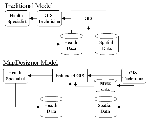
Figure 1. Traditional vs. MapDesigner’s model of GIS implementation at health agencies.
MapDesigner’s model bridges the chasm between spatially enabled health care data and health managers/specialists who can best make the decisions required for proper display and use of the information, including controlling public distribution of some of the inherent information. They receive a tool that makes GIS as easy to use as a word processor and soon be as important.
The role of the GIS technician is shifted from map creator to data and metadata specialist. Both roles focus on their respective strength.
Fiedler, R and Pruss, S A Strategy to Use Internet GIS in Spatially Enabling Organizations. Proceedings of Esri Conference 2000. 2000.
Thomas B. Richards, MD, Charles M. Croner, PhD, Gerard Rushton, PhD, Carol K. Brown MS, Littleton Fowler DDS, Geographic Information Systems and Public Health:Mapping the Future Public Health Reports 1999;114:359-373.