THE ENTERPRISE GIS INITIATIVE AT THE CITY OF CALGARY
By ROBERT EASON
ABSTRACT
The City of Calgary adopted an enterprise approach to implementing GIS in the early 1990’s. These early corporate GIS initiatives lost momentum in the late 1990’s. In 1998 a corporate Information Technology Review recommended that the credibility of the GIS initiative be restored and that alternative GIS products be investigated in order to provide solutions to clients. In April 1999, The City of Calgary selected the Esri suite of products and tools to support the revitalized GIS initiative. This paper will describe Calgary’s approach to implementing Esri technology, including SDE, for our enterprise GIS
It is common knowledge that very few initial enterprise GIS implementations are successful. The City of Calgary is no different when it comes to making GIS a success story. We to are in our second implementation of an enterprise GIS. This paper will elaborate on our experiences and the lessons learned along the way.
Calgary is situated on the eastern slopes of the Rocky Mountains in the southwestern portion of the Province of Alberta, Canada. Calgary has a population of over 840,000 encompassing 280 square miles. It is the sixth largest city in Canada with the second highest number of head offices located within a city. The populace is well educated with over 58% having a post secondary education and 61% having Internet in their homes (the highest total in Canada). It is a growing, vibrant city with over 9,000 new housing starts and 15,056 building permits totaling $2 billion issued in 1999.
The concept of a unified city with a population approaching one million, the above average technical knowledge and growth averaging 25,000 per year has all contributed to the necessity for The City of Calgary to take a second look at the value of a GIS to meet its business needs.
The City of Calgary has always been involved in mapping its spatial information. In the 1960’s The City of Calgary and the Provincial Government entered into an agreement to jointly develop very accurate (positional accuracy to within a few inches) mapping referenced to field survey control monuments. This is a very comprehensive surveying, mapping, computing and record-keeping program and is one of the finest base mapping systems in North America.
As part of this program we purchased one of the first electronic drafting systems in the late 70’s from M&S Computing Canada (the beginning of Intergraph – Canada). We proceeded immediately to convert our entire base mapping to electronic format (Computer Aided Drafting) and subsequently began to enter utility data and other spatial data referenced to the legal and ownership base mapping. As time passed, the pressures to use this data for things other than maps evolved.
The City started to investigate the feasibility of using GIS to meet its business needs in 1989 and began preparing an RFP in Nov 1990. A consultant was hired in the spring of 1990 to determine The City’s spatial data requirements and they concluded that The City was spending $28 million per year processing location-related data. They sold the concept of a GIS on the basis of small gains (1 to 2%) of the $28 million being spent annually. This led to the Calgary Spatial Information Management (CalSIM) project under which the GIS project fell. The CalSIM project lasted from 1991 – 1996 with a $15.6 million budget.
The CalSIM project was the first attempt by The City at establishing an enterprise GIS and although it did not achieve the results expected it had some successes. CalSIM was the first true data management project in the corporation and it was the change agent in several areas including; new technology (main frame to client server) and sharing of corporate data. It also established the cooperation and corporate commitment needed to implement GIS. It included the first major data gathering program (using aerial survey technology) to collect data not previously captured, which was referenced to our very accurate CAD base maps.
As a result of CalSIM, a wealth of data was created that represented significant value to the corporation. In addition most participants developed a good understanding of the concepts of data sharing and the opportunities for GIS technology.
So with all theses successes one might ask what went awry, so much that The City needed to revitalize GIS. In early 1998 the corporation undertook a review of Information Technology, which included a review of the GIS. The consultant hired to complete the survey discovered a number of factors that led to the loss of GIS credibility within the corporation.
In 1996 funding for CalSIM was expended and The City made a decision to end the project without having any focus group or body responsible for its implementation. This made the decision making process ineffective and time consuming. Business units were expected to embrace the technology and carry it forward, which in fact did not happen. Therefore when the CalSIM project concluded interest in GIS decreased significantly.
The GIS enterprise tool we were using was not serving the needs of The City. It lacked functionality, and hindered application development. The City was also spending far too much time and effort in compensating for the lack of tools, and the product had no desktop platform. It was an example of a product being "over-sold" and "under-delivered". The review culminated with three recommendations, which were needed to revitalize GIS.
In the fall of 1998 The City’s’ senior executive approved these recommendations and a project to revitalize GIS was established. The project had three goals; Selection of a GIS platform(s), establishment of a new organization to support development at The City and an implementation strategy to leverage our excellent GIS data foundation.
Fortunately, from the outset of this project, the Chief Information Technology Officer (CITO) acted as our champion. He believes in the value and potential positive impacts that GIS can have on the corporation and is a strong advocate of the technology. Not only did he support the project, but obtained the necessary project funding. He is a leader that "walks the talk". If anyone reading this paper takes one thing away, it should be that when starting to implement an enterprise GIS, a "GIS champion" at the executive level is essential; it just makes the job so much easier.
As the Project Manager, one of the first tasks was to assemble a team to follow through with the recommendations approved by the senior executive. Having come from a business unit that maintained, created and distributed spatial data for the corporation I knew the importance of getting business staff involved early in the process. I therefore selected four staff from the business units that had a vested interest in GIS or spatial data and were keen to have an enterprise GIS implemented. These resource commitments were (reluctantly in some cases) agreed to and supported by their management. With these resources in tow, our efforts turned to getting IT type resources on the project, choosing individuals that had past knowledge in spatial applications or were willing to get into the "nitty-gritty" of GIS development if need be.
It is important to have business and technical knowledge on any team of this nature to bring a sense of balance to the process, and believe it or not, they can and do compliment each other. When selecting IT resources for any GIS project, ensure a Database Analyst is on board full-time from the start; they are a very important commodity.
The consultant involved in the GIS review was contracted to participate in the initial phase of the project primarily in the GIS tool selection process. Their extensive knowledge of the leading industry GIS vendors combined with their technical expertise was a definite asset to The City while implementing our enterprise GIS.
On looking back I would say the selection of these key resources to work as part of the project team has had the most positive impact on the project and has dramatically influenced the success of The City’s’ GIS project to date. Organizations looking to implement an enterprise GIS would be wise to have key business personnel working directly on the project very early in the process.
Another component of the project was to form a senior management steering committee. Together with the CITO we assembled a group of senior managers to govern the project. We deliberately selected senior managers that had businesses actively involved in spatial information, operationally wanted to use GIS or had the budget and where withal to influence the use of GIS in the corporation. The establishment of the steering committee was strategically important to us when we implemented our enterprise GIS. The steering committee validated our approach, gave sound advice, yet let us be accountable for the project within the parameters that were established.
A conscious decision was made at the start of project to take a very aggressive approach to revitalizing the enterprise GIS. We could not afford to take an extended time to reestablish the credibility of GIS in the corporation because there was pent up demand for GIS in the corporation. If we didn’t address the issue, the businesses would seek their own individual solutions. This undoubtedly would have led to many GIS solutions with no focus and data sharing would have become increasingly more difficult.
We decided the selection of a GIS technology was to be completed within 6 months. Once selected we committed to develop a number of quick hit applications that would demonstrate the ability of the tool to actually meet the needs of the business units. This all needed to be completed before the infamous Y2K freeze was imposed in October 1999.
The corporation gave us clear directions that any tool we selected had to interface with corporate data, be well established in the industry, would interface with a number of 3rd party applications (buy versus build them in house) and had the ability to interface with future web development.
After the team was assembled we immediately surveyed all the business units to identify their GIS requirements. Forty-three business units were surveyed, 136 GIS-type applications (with some spatial component), 188 data sets and 257 top ten queries were identified.
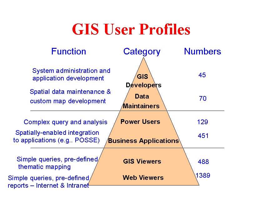
A GIS user profile was developed, as we realized those wanting to get involved in GIS ranged anywhere from a very casual user looking for information on a map via the web to power users which we classified as application developers or data creators and maintainers. The GIS tool we selected had to be flexible in dealing with this wide range of skills.
Understanding what the business units needed in the way of accessing, analyzing, maintaining and creating GIS related spatial data was another key ingredient and has attributed to our successes thus far in the process. Not only did it make us focus on selecting a GIS solution to meet these requirements, it determined our priorities for developing applications to prove the value of GIS in the corporation.
These user requirements formed the basis of the Request For Information (RFI). An RFI was generated within 8 weeks, contained over 150 pages of material and included over 650 technical questions the vendors needed to respond to. The RFI process included establishing evaluation criteria, evaluation methodology, benchmarking, vendor testing, and site visits. The net result led us to select Esri and we have been very pleased with the choice we made based on this RFI document/process.
The team, including myself was very determined to make this project a success and we continued with our aggressive schedule for the four-month time frame between software installation in July and Y2K freeze in October. Our plans included; replicating existing foundation data to the new GIS, development of "Quick Hit" applications and 5 modules of a web browsing application, decommissioning of existing GIS applications and integration with major business applications.
At the Esri user conference in 1999 Mr. Jack Dangermond1 confirmed in our minds that the approach we were taking to revitalize GIS was valid. In his presentation he talked about the "Five Keys to Success" in implementing a GIS. The keys were performing a user needs assessment, establishing a GIS Coordinating Committee, establishing a GIS Technical Team, building on a comprehensive Base Mapping Program and developing Interagency coordination.
This was one of those "warm fuzzy" moments, when we realized the approach we had embarked on was in fact the right one. When The City of Calgary speaks of implementing an enterprise GIS we truly mean corporate in nature covering public works, planning, transportation, transit, fire, police, ambulance, assessment, city clerks, social services and etc. At The City, it is our intent to provide GIS functionality and spatial information to all of these business units.
There are "Five Components of a GIS" required for any enterprise GIS technology implementation. Failure to integrate each of these components effectively means investments in GIS that do not meet expectations.
The hardware includes the computers, networks, operating systems, desktop PC’s, and peripherals on which the GIS operates.
The software is the GIS technology software that provides the functions and tools users need to store, analyze, and display geographical information including Database software, OS software and network software.
People are required to manage the system and to develop plans for applying the GIS technology and there is limited value in GIS without them.
Development of applications and well-designed methods describing how technology is applied is basic to any GIS implementation.
Data is one of the most important components of GIS. Accuracy, standards and access are absolutely essential.
The City is advanced in its infrastructure having adopted a client server environment early in the 1990’s. Servers are consolidated and sized for the needs of the corporation, PC/workstations are standardized and networks are being improved to handle spatial data.
With the selection of Esri as our enterprise solution and our site license in place we concentrated our efforts on other components such as data.
Data is one of the KEY critical commodities to The City’s organization. From our past experience on the CalSIM project we learned that accessing, sharing and consistent data management and maintenance strategies and routines are vital and we needed to continue to develop these strategies in our current project.
We guaranteed to the steering committee that spatial data would be available to the corporation regardless of whatever CAD or GIS software was being used to maintain the information. The City uses MicroStation software as the primary method for capturing Spatial Information. We decided initially to replicate data from the MicroStation environment directly into the Esri SDE environment for all data that we needed for the GIS applications developed.
The City has over 140 data features needing to be accessed by the GIS software. Significant progress on making these data sets available has been made; they are all replicated and QA/QC processes have been automated. Data change control mechanisms, and creation of metadata using ArcCatalog accessible on the Intranet are operational.
To re-establish the credibility of GIS, we had to develop applications that could prove its value and simultaneously provide functionality as identified in our Users Needs Assessment at the beginning of the project.
The Web (INTRANET) application developed was based on a web delivery strategy that;
The Intranet web application was delivered in five phases;
The Quick Hit applications developed were based on a strategy that;
The web application and quick hit applications using the above strategies demonstrated to the corporation that GIS could and should be considered as part of its business strategies. We learned during this process that our time estimates were suspect. As we learned the Esri tool and gained insight into its functionality, these estimates needed to be revised. When we presented the three-year business plan to our senior management, every effort was made to ensure they understood this and as it turned out they were very supportive.
The City was fortunate our spatial data was stored in Oracle and that we did not have to deal with a number of legacy systems, including no data maintained from an Esri environment. Our roll out strategy therefore focused on the use of ArcView and its extensions to access and query spatial data and display the results. Replication of spatial data became an immediate strategy with the understanding that future maintenance of spatial data would take advantage of the ArcInfo 8 technology.
Maintaining spatial data using ArcInfo 7 technology was not promoted and has been limited to only a few special circumstances. The ability to replicate data has gone smoothly because of good source data and the excellent functionality of the Esri tools. This provided us the opportunity to leave maintenance in its current environment (MicroStation). This is important to the users as it provides them the freedom to learn the new tool and determine where their spatial data maintenance should be performed (we believe in a number of the cases they will choose ArcInfo 8 as their maintenance environment).
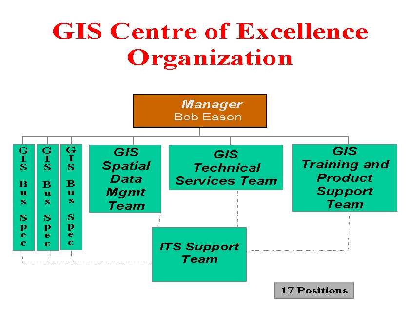
An organization (GIS Centre of Excellence) to support and sustain GIS technology in the corporation is now in place. The roles for the business unit are to coordinate and facilitate GIS integration into the business units, to ensure GIS investments are managed, to coordinate and manage data standards and data sharing, to develop strategic policies and assume a leadership role in the GIS technology within the corporation.
It is often good to look back to see how we have progressed. When we compared what we did to implement an enterprise GIS in 1990 to this project in 1999 it is apparent we have learned some things in the process.
|
1990 |
1999 |
|
- Part time team (40) |
- Full time team (12) |
|
- Limited GIS knowledge |
- Experienced in GIS |
|
- Multi-year selection |
- 6 month selection |
|
- Best of breed |
- Best in market |
|
- Build Vs Buy |
- Buy Vs Build |
|
- No GIS organization |
- GIS Centre of Excellence |
|
- No governance |
- CITO authority, GISCOE responsibility |
This very exciting and worthwhile project which is being re-introduced to improve the ability of businesses to implement solutions has taught us some important lessons.
As long as we never stop learning and applying what we have learned we will be successful in implementing GIS technology. The City of Calgary has learned from its past experiences and is well on its way to revitalizing GIS at The City.