Ofer Nedivi
Liat Noy
Michael Ginzburg
MAAGAN - GEOGRAPHICAL PORTS SYSTEM
Complex GIS solution for sea ports developed by Atlas Geomatics for the Ports and Railways
Authority of Israel
General Background
These days a geographical Information System (GIS) developed by Atlas for
the Ports Authority - the Maagan- has entered the practical operation stage.
In recent years, the Ports and Railways Authority (PRA) has been going through
a development momentum, within which new ports are being located, and measures
are adopted to improve the management and operation of the existing ports. As
part of the PRA's overall preparations, it was decided to set up a
geographical information system. This is a system that concentrates all the
geographical port information relating to engineering, assets and lands
subjects, allowing the users in various departments to retrieve the
information, to interrogate it in a geographical manner and to produce the
appropriate maps. This project included the development of a computer system
and in parallel, to setup a geographical database for all ports. The system
serves the Head Office of the Ports Authority and all three ports - Ashdod,
Haifa, Eilat - and is part of the current activities and work processes of the
Authority's geographical information consumers.
The Project
System development is but only one stage out of several project stages:
System Capacity
The system integrates the work processes of the PRA in connection with various subjects:
- Management of engineering and other projects.
- Management of real estate and landed property
- Management of assets and contracts
- Management of engineering infrastructures
- Management of operational infrastructures
The main capacities of the Maagan System are the following:
- Information Inputting and Editing - Users ([in accordance with the authorization array, of course) can update the information for system items. This update can be alphanumeric (update of the item's properties) or graphic update, including such graphic editing activities as adding items, shifting them, changing their shape, etc.
- Interface for Transferring Information between CAD and the Maagan System - Development of the application, including development of the converter, enabling conversion of the prepared information - as per the PRA's specifications for Engineering Planning Tools (CAD) - into information appropriate for the Maagan System (GIS). This converter works in two directions, so that it is possible to import information from AutoCAD to the system, as well as to export the information located in the system to AutoCAD files, which can be transferred to planners and contractors.
- Control of Information Configuration on the Screen - The user can decide which information he wishes to see, how to display it and in which sector of the port he wishes to zoom in.
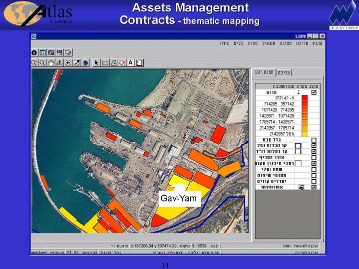
- Dynamic Interrogation - It is possible to search for information that satisfies any sort of conditions. For example: it is possible to search for all infrastructures set at a given depth, or to search for all the contracts entered into with a given customer, or all the wharves capable of carrying loads with a given weight, etc.
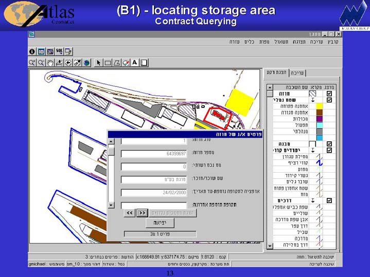
Picture: Contracts querying.
- Predefined Interrogations - The system includes several fixed interrogations, which were defined according to users' demands.
- Production of Maps - The system includes several fixed map "patterns" with which the user can produce a map, including all the information he chose to display, with all the conventional cartographic components, such as coordinate framework, scale ruler, North arrow, etc.
- Production of "Contractual Cards" - It is possible to produce all the information in the database on any contract, including a map that displays the contractual place and all things that can be found in its immediate surroundings.
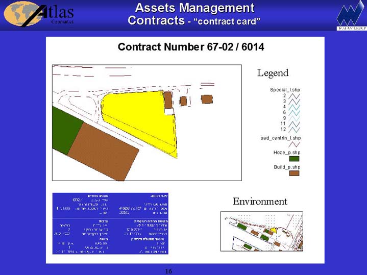
Picture: Contractial Card.
- Link with Various Documents - All the items in the system can be linked (building, contract, sewage pipes, wharf, etc.) to various kinds of documents related to it. For example: to link to the building it's detailed plans, Word documents, photos, etc.
Linked documents may be easily viewed.
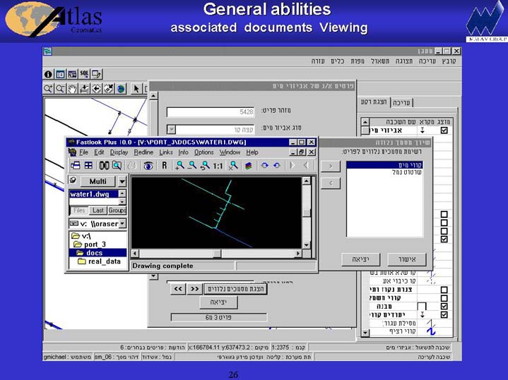
Picture: Viewing linked drawing of water pipe
- "Live" linking to Interfacing Systems - The system includes a link to additional systems extant in the network, such as for example the contractual system that runs on HP computers, the Drawing Archives System and the Maintenance Management System.
Technology
The system was developed with a client / server architecture in an NT operating system environment (servers and worstation stations). The database is ORACLE, and the development environment is Visual Studio 6. In addition, system development includes a number of aids in the fields of (Esri-made) GIS and CAD:
- ArcSDE - an engine for graphic data management above the relational database.
- MapObjects - A component (OCX) to combine the GIS capacity with Windows applications.
- ArcCAD and AutoCAD - to develop the whole converter mechanism for transfer of information to and for external factors.
- Extensive use of the newest technologies including OLE, COM, ADO, etc.
The system is activated in 4 different sites (the 3 ports and the Main Center at Tel Aviv), connected to each other by WAN, while performing synchronized automatic linkage to the database every night.
At present the system is subject to a new configuration, which matches the Windows 2000 Operating System with client stations based on Windows 95 using the Windows 2000 Terminal Server mechanism.
Advantages
- Ease of Use
The system is simple and easy to use. It does not require its users to have technical knowledge of such software as AutoCAD or a complex GIS system.
- Easy Communication with External Factors
The system includes an interface for transfer of information between CAD and GIS, which allows for a more efficient stream of information among all the factors involved in the planning of ports and current work, while creating standards for transfer of information among the various factors.
- Central, Uniform, Reliable and Accessible Database
All the information is concentrated in a single place; however it is accessible to all the users in the system. Thus, it saves them from having to search for information extant previously in different port departments.
- State-of-the-Art Technology
Even though the work is simple from the point of view of system users, this system makes use of state of the art tools. The geographic database is le dernier cri in the GIS field throughout the world, and the system works in the Windows 2000 Operating System.
Atlas Geomatics
Ofer Nedivi Tel.: 972-3-5312282, 972-3-51514316 ofern@atlas.malamsys.com
Liat Noy Tel.: 972-3-5312275 liatn@atlas.malamsys.com
Michael Ginzburg Tel.: 972-3-5312148 gmichael@atlas.malamsys.com