This project is an interesting illustration of the many challenges facing modern GIS developers. The BCRC saw the need for a comprehensive GIS, but had to be able to integrate its existing CAMA database and information from hardcopy maps into a new digital spatial format � NovaLIS Parcel Editor for ArcInfo. In addition, several BCRC users must be able to edit the spatial database simultaneously with all of their changes integrated into the master database files. The final product supports multi-user access, spatial analysis, a method for retrieving data from the mainframe CAMA database, and high-quality cartographic output.
The first step in the process is to convert the existing BCRC data into a digital database in Esri�s ArcInfo format. To do this, the original mylar hardcopy map sheets were scanned and converted to vector format using Intergraph I/GeoVec software running on top of Bentley MicroStation CAD software. I/GeoVec converts the raster binary raster images generated by the scanning process into vector linework that can be imported as separate data layers (from CAD levels into ArcInfo coverages). The BCRC database design manual, created through a previous contract with another vendor, calls for separate data layers for many different map features. In all, 186 individual map feature-types are being captured in CAD format, then they are being grouped into 12 ArcInfo coverages. The database design separates items such as public land survey grids, parcel polygons, and historic lot lines. Since all of these features are present side-by-side on a single mylar map sheet, 3001 had to develop a set of custom tools to recognize the unique attributes of each feature and populate the right groups with the right linework. In effect, the program recognizes different feature types on the scanned maps and separates them from each other to produce discrete data layers.
The next step is to format the ArcInfo database for multi-user access. To accomplish this, a subsystem of ArcInfo called Librarian was used. (Note that Librarian was chosen over Esri�s Spatial Database Engine (SDE) for the initial implementation on ArcInfo version 7.2.1; but the ultimate goal is to migrate to SDE within the next two years upon upgrading to ArcInfo 8.) Librarian creates a digital �spatial library� that functions much like a traditional library of books. Librarian partitions the digital database into files of manageable size. Users can �check out� Librarian tiles just like a library patron would with books. Librarian records information about who has which tiles checked out. This prevents multiple users from editing on top of each other�s work. When the user is finished editing data from the Library, he or she simply checks the tile (or tiles) back in. Now that tile(s) is available for other users to edit and they can see the changes made by the previous user.
With the database operational in ArcInfo Librarian, the next step is to develop custom tools and configure the system to work with NovaLIS Parcel Editor (PE) 3.3. The PE product is an ODE-based application which operates on top of ArcInfo. With support for macro development inside PE 3.3, custom functionality is being added to the final BCRC system through Arc Macro Language (AML) and Visual Basic (VB) coding.
The final implementation will result in all 90,000 parcels in Baldwin County being integrated into NovaLIS Parcel Editor and widely available as ArcInfo coverages and ArcView shapefiles. The BCRC is providing copies of the data sets to other agencies throughout the county. The new system will incorporate existing parcel data in a fully digital environment which will allow for faster access to the system with a decrease in maintenance and update costs.
Baldwin County Appraisal Department (BCAD)
The BCAD uses the CAMA database to query sales information. Being able to spatially represent sales information has been a limitation that the BCAD has faced when using the CAMA database. Updating sales information on parcel maps has involved pulling the hardcopy parcel map and physically writing the sales information into the parcel. Not only is this a time consuming method of updating sales information, but also the appraisers cannot take the original parcel map to the field.
In the current revision of the BCRC�s DELTA (Delta Computer Systems, Gulfport, MS) application, which operates on an IBM AS400, there are several limitations placed on querying the sales data:
Can Only query by a single year
Cannot query multiple neighborhood codes, acreage, bedroom, bath, square footage, etc...
Requires manual updates on old parcel maps
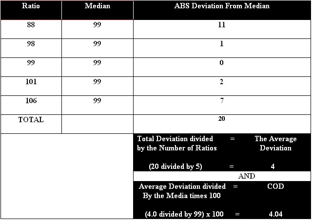
Initially the goal of the BC GIS department was to spatially represent queried information, but the BC GIS decided to enhance the querying power of the BCAD.� The BC GIS department has created an application (RevQuery) using Avenue (ArcView 3.2) to query the same sales information that the CAMA database stores. The CAMA data is accessed through an ODBC connection. Within Avenue, a SQL query string is developed though user interaction, such as parcel ID, acreage, number of bathrooms, etc. The SQL string is passed to the AS400 to query the CAMA data. The returned information is exported into a dBase file. After the data is exported into a dBase file, an Avenue statement does calculations on the data to return fields containing sales ratio (�Assessed value� divided by �Sales Price�) and Coefficient Of Dispersion (The COD is the appraisal quality within a class (home quality) or area within the county. The COD measures the average percentage by which an individual ratio varies from the median ratio. (see Figure A)). When all the calculations are completed, the resulting data is used to select the matching parcel in the parcel coverage and highlight it within ArcView. RevQuery allows appraisers that have limited experience with ArcView to produce a sales map easily to take to the field.
Quicker updates and possibly lower cost are benefits of the BC GIS developing an application in-house. In order to make quick updates, the BC GIS department built RevQuery in a modular form. The modular form allows for several people to work on the different modules without sacrificing the integrity of the application. Another advantage of a modular application is not having to search through thousands of lines of avenue code to locate an error.
Another encouraging aspect of integrating cadastral mapping into the BCAD is facilitating the building of the BC GIS database.The BC GIS department currently has a point coverage containing all structures within the county that are 15�x15� or larger.The BCRC has plans to purchase several GPS units to map structures that extend past the most recent ortho photography (February 1996).Along with mapping new structures, the BCAD plans to attribute the existing structure file with the following information:
Addresses (Not only useful for BCAD, but also E911)
Structure Type (Residential, Commercial, Barn, etc.)
Primary Building within a parcel
PIN#(A unique number associated with the Parcel ID for connection to the CAMA database)
Other features the BCAD will obtain are:
Underground Utilities
Swimming Pools
Cell
Towers (Many cell towers have been un-taxed because of missed assessments)
RevQuery and all of the features and attributes described above will help the BCAD save valuable time and provide a more accurate assessment.
Baldwin County Mapping Department (BCMD)
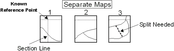
The BCMD currently maps updates, additions, and deletion of parcels by hand. Through the use of Parcel Editor and the parcel coverages, the BCMD will migrate into the digital world. A big plus for the both the BCAD and the BCMD is the seamless parcel coverage of the entire county. With hard copy parcel maps, a mapper is dependent on the scale at which the map was created. For example: a grant section (land that was deeded before conventional parcel mapping) map encompasses three separate map sheets in which a split must be performed on the third map sheet. The only known reference point is located on the first map sheet. In order to perform the split on the third map sheet, all three maps have to be taped together to acquire the proper measurements from the known reference point. The seamless digital parcel coverage allows for this to become a minimal effort task.
Baldwin County�s rapid growth warrants 150 to 160 new subdivisions every year and increasing road rights-of-way (ROW). Mapping a new subdivision involves not only curves and lines, but also bearings and annotation. Baldwin County has recently required that developers submit plats in a digital format (DXF, shapefile, etc.). As for ROW, extensive manual mapping is involved when a road is increased from a two lane to a four lane. Time saved in the digital world will expedite the workflow.
Conclusion
The Baldwin County Revenue Commission, Southeast Digital Mapping, and 3001 are working in partnership to develop the preeminent cadastral GIS in Alabama. When complete, the system will provide real-time access to property information to the public and other government agencies. Future directions include public-access terminals (a MapObjects application), field-based assessment GIS (an ArcPad application), and an Internet GIS system (an ArcIMS application) all integrated with NovaLIS Parcel Editor, NovaLIS Assessment Office, and Esri ArcInfo and ArcView.
(Figure A)