Using the Internet and GIS for Surface Water Improvement Management
Chaula Jain, GIS Programmer
Analyst
Joyce Brown, GIS Specialist
Defining Issue:
Mecklenburg County is located
in the southwest portion of North Carolina bordering the South Carolina State
line at its southern end. It is one off the fastest growing counties in the
United States and has a full-fledged GIS system, which is being used by several
of the county departments. During the last year GIS and the internet have both
been utilized for development of applications
for Surface Water Management.
The application is developed by
Chaula Jain GIS Programmer Analyst,
Department of Information Services and Technology in association with
the Joyce Brown of Department of Environmental Protection from Mecklenburg
County, North Carolina.
Internet Application:
The application serves as a
tool to access a range of data related to environmental issues pertaining to
Mecklenburg County's Surface Water Quality Rating. Mecklenburg County's Water Quality Rating (WQR) provides a
general summary of water quality conditions in the county's lakes and streams
through a measure of chemical, physical and biological parameters. The WQR is
represented on a scale from 0 to 100 with higher values representing better
water quality conditions. Only waters with a "Good" rating or better
are suitable for prolonged human contact. Waters below a "Fair"
rating will stress aquatic life resulting in significantly reduced fish
populations.
In addition, it also will
provide the proximity for a specific tax parcel in relation to Mecklenburg
County stream buffer requirements.
This application will enable the users, primarily builders, to ensure
that they are meeting the requirements of the stream buffer ordinance for
Mecklenburg County. This will also
allow the user to print copies of the maps.
Water quality data is queried by date of sampling, which is broken down
into quarterly and yearly reports. The
query also allows the user to query by address or a tax parcel and acts on
various coverage’s such as: floodplains, streams class, greenways, street
centerlines, and buffers.
Software: All the data for the above applications is
contained in either ARC/INFO coverages
or ArcView themes or AutoCAD files,
which have been converted to shapefiles. The applications are built with Visual
Basic, Map Objects, Map Objects Internet Server, Java Scripts & HTML
The Internet application can be
viewed through any web browser like Netscape Navigator or Internet Explorer.
Upon establishing connection to the right site, a startup screen with a picture
appears. The application can be accessed upon clicking on the picture.
INTRODUCTION
Mecklenburg County:
Mecklenburg County is located in the southwest portion of North Carolina Bordering the South Carolina State line at its southern end. It is one off the fastest growing counties in the United States and has a full-fledged GIS system, which is being used by several of the county departments.
Mecklenburg County GIS team has worked with a number of departments in the county trying to assess their special needs and assisting them in application and database design. One of their clients during the last year was Mecklenburg County’s department of Environmental Protection.
Mecklenburg County GIS team developed a set of Internet applications for the Department of Environmental Protection to view and analyze its data.
The application is in two parts, the first one displays the Water Quality Rating for areas within the county.
Water Quality Rating
An index of water quality is a mathematical means of transforming large quantities of water quality data into a single number that represents a level of water quality eliminating the subjective assessments of water quality and biases of the individual water quality expert. To assess water quality in Mecklenburg County streams, the Mecklenburg County department of Environmental Protection (MCDEP) is using the general water quality index developed by Brown, et al. (1970) and improved by Deninger (1979) for the national sanitation foundation (now NSF International). The index includes the following 9 parameters: Biochemical Oxygen demand, dissolved oxygen, fecal Coliform bacteria, pH, temperature, total Nitrate, total Phosphorus, Total Solids and turbidity. These parameters were selected through the combined judgment of a panel of water quality experts residing throughout the country.
How is it generated?
MCDEP is using a modified version of the index developed by Fusilier (1982) to evaluate the quality of water in county’s lakes. The lake water quality index include the following 9 parameters: Chlorophyll a , Dissolved Oxygen, pH, Secchi Disk Depth, Specific conductivity, temperature, Total Alkanity, Total Nitrate, and total Phosphorus. This index has been shown by Fusilier (1982) t o be sensitive to changes in lake water quality.
MCDEP is collecting water samples from 40 stream sites and 17 lake sites each month. These water samples are analyzed by MCDEP’ laboratory. The data generated from these sampling activities is used by MCDEP to produce water quality index monthly throughout the year. These index values are used by MCDEP to compare stream and lake water quality conditions over space and time as well as to establish trends in water quality and to evaluate pollution.
What does it tell us?
The water quality Index represents water quality on a scale of 0 to 100 with 0-25 representing poor water quality; 26-50 fir water quality; 51-70 Average water quality; 71-90 good water quality; and 91-100 excellent water quality. Both Excellent and good water quality lakes and streams support a high diversity of aquatic life and are suitable for all forms of recreation. Average water quality lakes and streams exhibit signs of stress including reduced diversity of aquatic organisms, increased nutrients and increased algae growth. Fair water quality lakes and streams support a low diversity of aquatic life and are experiencing water quality problems from point and nonpoint sources of pollution. Poor water quality lakes and streams may support only a limited number of organisms that are very tolerant to pollution and have abundant water quality problems. Poor water quality is not suitable for recreational activities involving frequent human body contact (i.e. swimming, wading, skiing, etc).
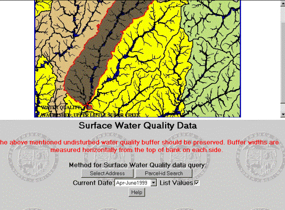
WATER QUALITY APPLICATION:

This Internet application and can be accessed on the web at
http://engbs.co.mecklenburg.nc.us/html/epa/epa.htm.
The main spatial layer which the application works with is the watershed file for the entire county. Each watershed has attributes for surface water quality ratings for last three years categorized on a monthly or quarterly basis. There is a Street centerline file, which is used for geocoding addresses. Since the county has acquired the entire parcel coverage for the county the parcel file is also used for exact locations of properties.

The application lets a users choose a date from a scroll down list and displays a relevant map with surface water quality ratings. The watershed are colored in a standard way and a corresponding legend appears in the corner. The user can also determine the rating for specific addresses by selecting the address or parcel id search. The application tries to first locate the parcel and if it cannot find the parcel then it resorts to geocding. The legend describes the water quality rating classification described earlier.
All the regular functions of Zoom in, zoom out, pan, refresh can be performed on the map. The identify button lets you identify individual watershed names and water quality rating for each map corresponding to different dates.
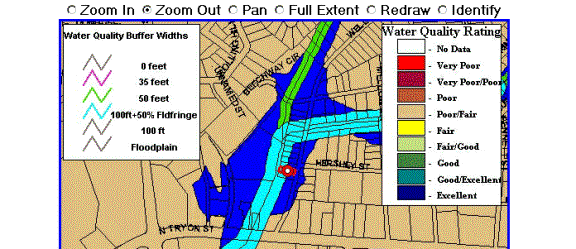
SWIM BUFFER APPLICATION
The second application helps to determine buffer widths for streams and to help users of the application comply with the requirements of the stream buffer ordinance for Mecklenburg County.
In November of 1999, Mecklenburg County and the City of Charlotte passed the Surface Water Improvement and Management (S.W.I.M.) Stream Buffer Ordinance. This ordinance requires the establishment of buffers along Charlotte-Mecklenburg streams in order to protect the integrity of the stream system and ensure that streams and their adjacent lands fulfill their natural functions.
Mecklenburg County is fortunate to have abundant surface water resources including over 3,000 miles of streams. Unfortunately, the water quality of these streams has been compromised by sediment, polluted storm water runoff, land development and habitat destruction. Increases in impervious surfaces (parking lots, roads, etc.) have further contributed to the problem. Adherence to the new S.W.I.M. Stream Buffer Ordinance and voluntary participation in buffer enhancement projects will prove critical to the future protection and restoration of water quality in Mecklenburg County's streams.
In general, the new S.W.I.M. Stream Buffer
Ordinance requires forested buffers on streams draining 100 or more acres. A buffer is defined as the
forested/vegetated area on both sides of the stream. The width of the buffer will vary according to the size of the
watershed. (see chart)
Natural Functions of Stream Buffers
Decrease velocity of storm water, thereby reducing risk of erosion.
Store flood waters.
Allow streams to meander, creating a
diversity of habitats.
Filter out pollutants, sediment and excess nutrients.
Shade stream channels, thereby decreasing water temperature.
Provide wildlife habitat and corridors.
Greenspace for parks.
*Buffer widths are measured horizontally on a line
perpendicular to the surface water, landward from the top of the bank on each
side of the stream.
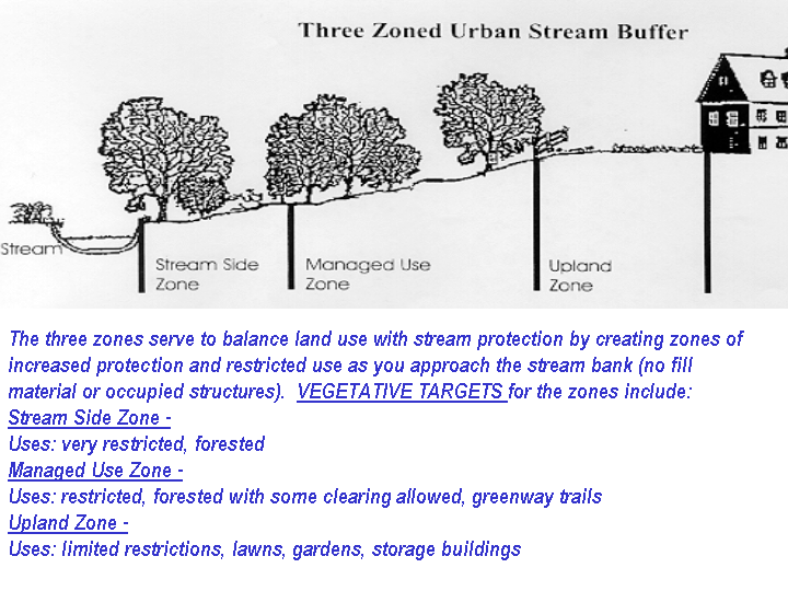
The "Three Zoned Urban Stream Buffer" design offers a good balance of land use and stream protection.
Stream Side Zone: the stabilization and protection of this zone is critical to water quality; clearing and cutting of vegetation is not allowed, permitted uses include-flood control structures, bank stabilization, utility/road crossings.
Managed Use Zone: this area provides space for the storage of flood waters and the filtering of pollutants; limited clearing is allowed but existing tree density must be retained to a minimum of 8 healthy trees (minimum 6"caliper) per 1000 square feet, greenway trails/bike paths are allowed.
Upland Zone: area located furthest from stream,
grass is allowed; gardens, gazebos, decks and storage buildings (<150 sq.
ft. in size) allowed.
Three Zoned Urban Stream Buffer
Newly restored or young forested buffers may appear "brushy" at first, however, over time the forest appearance will improve as a result of natural succession. Thick understory growth will naturally be replaced by rich woodland plants and moisture-loving, hardwood trees.
CONCLUSION
The web application has really helped reduce phone calls and visits to the Department of Environmental Protection.Individuals who have purchased a piece of property or are having a house constructed can find out exactly what buffer requirements have been assigned to the lot/parcel. All they need is the address or parcel # to access the information on the web. Thus we can conclude that GIS and the web are proving to be extremely powerful technologies.
Acknowledgements
Author information
Chaula Jain
Programmer/Analyst
Mecklenburg County Department of Information Services & Technology
600 E 4th Street
Charlotte, NC 28202
Tel: (704) 336-4322
Fax: 704) 336-7219
EMAIL: jaincm@co.mecklenburg.nc.us
Joyce Brown, GIS Specialist
Mecklenburg County Department
of Environmental Protection
700 N. Tryon St
Charlotte, NC 28202
Tel: 704-336-5500
Fax: 704-336-4391
EMAIL: brownjp@co.mecklenburg.nc.us