William Schroeder
A new MapObjects-based application, MaxResponder™ brings geospatial power to the aid of Fire, EMS, Police, HAZMAT Spill Response, Emergency Management and other agencies responding to everything from small house fires to large-scale terrorist incidents. MaxResponder™ includes an Administration Module which allows organizations to create and manage their own first responder databases including strategic pre-plans and floor plans geo-linked to their own custom GIS layers. In order to allow remote data entry of pre-plan data into the database, MaxResponder™ also includes a Data Collection Module. Finally, to distribute this geospatial database in the field, the MaxResponder™ Mobile Module gives responders a user-friendly in-vehicle geospatial solution.
|
|
|
INTRODUCTION
Utilizing Map Objects 2.0, a collection of embeddable mapping and GIS components, MaxResponder™ brings geospatial power to the aid of Fire, EMS, Police, HAZMAT Spill Response, Emergency Management and other agencies responding to everything from small house fires to large-scale terrorist incidents. MaxResponder™ was designed to provide a universal, in-vehicle capability to bring together on one screen, a graphic display of all the relevant information necessary to support first responders.
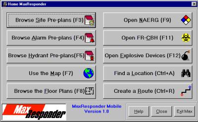
MaxResponder™ includes an:
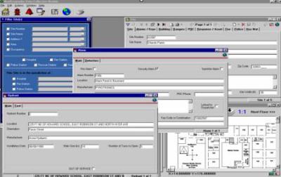
Administration Module which allows organizations to create and manage their own first responder databases including strategic pre-plans and floor plans geo-linked to their own custom GIS layers. This module allows for the addition/removal of map layers and floor plans, editing of map and layer properties and the linking of pre-plans to map layers.
Even though MaxResponder™ comes with standard GDT Dynamap Transportation map layers for specific county or counties, it is designed to incorporate maps layers from existing local jurisdictions or to create layers using the Data Administration Module.
Data Collection Module allows remote data entry of existing addressable structures, sites including fire, police intelligence, HAZMAT, building and other inspections, and the most current pre-plan data needed by first responders into the master database. This uniform updating of new and existing addressable structures is essential to public safety.
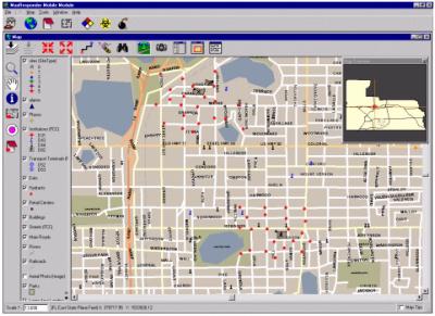
MaxResponder™ Mobile, the in-vehicle solution that distributes the geospatial database to first responders in the field. Within seconds after entering the location data, MaxResponder™ centers the emergency site location, provides situational awareness, queries site information, imagery, street names, zooms in and out, turns on legends, and accesses floor plans. MaxResponder™ also provides embedded national handbooks such as Chem-Bio, NAERG and the Improvised Explosive Device Handbook, which includes the necessary information to handle an IED incident before the bomb squad arrives.
PROBLEM
Quick access to emergency information is critical for first responders. Currently, most first responders must deal with a paper-driven system of handbooks, mapbooks, and neighborhood data that is not always up to date or organized for quick access. An additional problem is that dispatch and command centers have a tremendous amount of data at their fingertips, but no way for responders in the field to view it. MaxResponder™ has incorporated these components into a single tool, which integrates instantly the information necessary to answer emergency calls with speed, knowledge and confidence. With this application running on mobile data computers or laptops, first responders have at their fingertips a visual perspective of the incident site, routing directions, and the data required to arrive on the scene in control and ready for implementation.
THE TOOL CHEST
GIS data plays an integral role in the MaxResponder™ application. The GIS map data that is used in MaxResponder™ have some critical requirements. Understanding the kinds and types of GIS data that can be used with MaxResponder™ is vital to using the application with your own custom GIS data. The current version reads Esri shapefiles and coverages. MaxResponder Version 2 will also support Esri Spatial Data Engine (SDE) layers.
The GIS data used in MaxResponder™ can be both vector drawings (point, lines, polygons) or raster images (aerial photography, satellite imagery, etc.). Each drawing or image is called a map layer. For MaxResponder, the vector layers are the most important because they associate attributes for each point, line or polygon stored in that layer.
MaxResponder™ uses these attributes to perform interactive operations like locating addresses, routing, labeling, and identifying, to name a few.
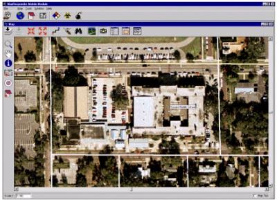
This leads to raster image layers. Image layers such as aerial photos contain a great deal of spatial information, but there are no associated attributes because there are no individual objects like points, lines or polygons. Even though this is not an interactive layer, it provides a great deal of information as a viewable background when used together with vector layers that have attributes.
Due to the different types and functions of layers, MaxResponder™ utilizes three categories; Active, Inactive, and Background to describe map layers. The ttwo active vector layers that are used by MaxResponder directly are the "sites" point layer and the "streets" line layer. The "sites" layer contains the points on the map that mark the location of each Pre-plan site in the database. It is possible to have a site pre-plan entered into the database with no associated site point. But without the site point, there is no link from the pre-plan database to the map. This layer is uniquely created from within MaxResponder from the Pre-plan entry form. The "streets" layer consists of the lines that represent the streets for the map. This layer is normally supplied to the user with MaxResponder™ as part of the GDT "Dynamap 2000 Transportation" GIS data set. This GDT layer contains many attributes required for MaxResponder™ to function properly, such as street names, address ranges, travel time values, and one way street codes. Without these attributes, MaxResponder™ cannot locate addresses, create routes or label streets. In addition, the GDT street layer is topologically correct. This means that all lines intersect where they should and no unattached extra lines are part of the layer. This is very important for routing purposes.
A local street layer can also be employed as the active layer. Prior to doing this, an assessment and evaluation should occur between PSC and the local data custodians of the street layer to determine whether there is a match with MaxResponder™.
There are three other active layers that are used as map location links for the program and they are "hydrants", "alarms", and "stations". These layers are not required for the application to run, but without them, there can be no link to the hydrant or alarm location on the map from the corresponding record in the database.
The inactive layers are those that have at least one useful attribute used by MaxResponder™ for identifying or labeling objects on the map. These layers are not required for MaxResponder™ to function.
MaxResponder™ can also use map layers simply as background layers. Any layer with no attributes or any layer that is not set up as an active layer by the administrator can be used as a background layer. Image layers also fall into this category. They are used strictly as background and do not have attributes.
SOLUTION
MaxResponder™ is designed specifically for the public safety market. Any local, state, or federal emergency service provider responsible for the oversight of the safety of individuals, facilities or property would directly benefit from this product.
MaxResponder™ also provides communities who have made an investment in geospatial data to deploy those resources in support of the protection of public safety and the efficiency of first responders. With one keystroke on their mobile module, fire fighters, emergency, medical and police responder personnel can access the location, evaluate the danger to adjacent areas, and utilize specific sub-applications to determine responsive actions.
There is currently no competitor with a GIS-based mobile computing solution for public safety. There are, however, several wireless-enabled applications that will provide messaging of building/site/hazard data to a mobile computer. These applications cannot transfer either geospatial data or floor plan data.
Due to the flexibility of the MaxResponder™ sub-applications and database, MaxResponder™ can be modified to fit specific emergency requirements. PSC is currently adapting MaxResponder™ to support Integrated Spill Contingency Plans (ICPs) for several customers with facilities bordering the Atlantic and Pacific.
MaxResponder™ has been designed with integration into a comprehensive public safety system in mind. It can be interfaced with CAD E/911 Dispatch Systems, Record Management Systems (RMS), PDAs, CDPD/800Mhz wireless communication systems, GPS/AVL, and other technologies.
CONCLUSION
MaxResponder™ is both a tool for integration of area-specific data and a reference tool with extensive databases on chemicals and weapons responses. It provides a tool set in which a municipality’s investment in geospatial data can be used to save lives and property by bringing that information to the first responder in the field at the time of the crisis. It provides real-time images and data necessary when responding to an emergency incident site. Unlike the current computer-aided dispatch solutions, MaxResponder™ offers situational awareness by providing integrated geospatial data management that reduces manpower and improves efficiency. AVL/GPS systems can be used to provide and display current location and routing functionality within MaxResponder™. Wireless interfaces between MaxResponder™ and 911 and/or communications centers can also be supported.
PSC's commitment to public safety is apparent in its expanding partnership in the community to provide strategies emphasizing emergency prevention awareness and preparedness. Many localities have the data needed to react to an emergency situation, but lack risk reduction measures or tools to assist first response personnel. Identification of problems prior to the arrival of the unit on the scene ensures that necessary precautions are taken and additional manpower can be sent. MaxResponder™ increases response time, alerts the community and public safety personnel to potential dangers, affords better decision making and above all - saves lives.