Dr. Korsey Sergey G.
Project objectives:
1.The project "Sentinel" is developed for the informational support of Russian Military forces in Kosovo (RMF) cooperation with KFOR while performing Safety Council decision from 10.06.99 No. 1244.
2.Development System Support Decision (SSD) of RMF actions in Kosovo.
The project's basic information procedures, developed according to RMF tasks are:
1.Prevention of battle actions renewal, maintenance of the fire termination, hostile military forces exiling and prevention of their returning in Kosovo:
- control for the KFOR's plan performance of the hostile military troops withdrawal from Kosovo;
- terrain permeability analysis and offers on counteraction of the hostile military troops invasion;
- information interaction with KFOR on the hostile military troops withdrawal.
2.Creation of the conditions for the refugees returning, creation of the temporary administrations and functioning of the civil presence institutes
- development of a ethnic map of the Serbian and Albanian population compact and mixed residing, analysis of the population migration during conflict development;
- finding optimum RMF patrol routes, arrangement of posts and control places;
- information interaction with KFOR on the refugees problems.
3. Demining of district, roads and objects:
- terrain mine investigation, information interaction with KFOR;
- mine condition maps creating and development, taking a part in general demining Kosovo plan;
- using of some network optimization decisions at terrain demining;
- development of the plans and measures of the local population acquaintance with rules of the manipulation with explosives.
Introduction
The roots of the ethnic conflict in Kosovo ("Kosovo" means "land of the blackbird") goes deeply in a history of this country. The vyzantian historians have recorded Serbs appearance, as a nation, in Kosovo already at the end of 9th century. During the numerous wars Kosovo repeatedly passed from the Serbia to Turkey and back. The last 50 years have gone in constant opposition between the Albanian community and Serbian population in Kosovo, which is now an autonomous region of Serbia.
Recently the situation in Kosovo has become complicated and dangerous. Albanian separatists put pressure on Serbs and Montenegrians to abandon country, using different violence methods. An economic crisis in Kosovo aggravates the situation which become critical. The last possible way to stop humanitarian debacle and mass population fleeing was to bring military forces into this region for peace maintenance under aegis of the United Nations (KFOR).
According to the Resolution of Safety Council from 10.6.99 No.1244, the Decree of the President of Russian Federation from 25.6.99 No.8220, and also the "Agreement of the Russian participation in KFOR", signed by the RF and USA defense ministers 18.6.99 in Helsinki for peace maintenance in Kosovo republic the Russian military forces (RMF) is located.
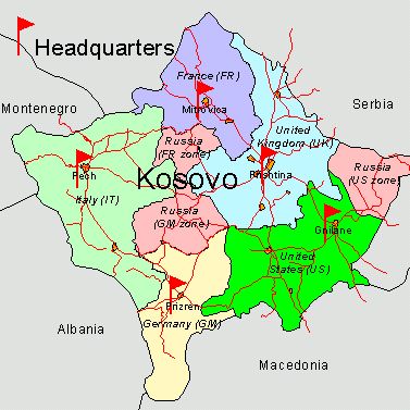
The responsibility zones controlled by KFOR are given for RFM tasks fulfillment (fig. 1).
Figure 1. KFOR responsibility zones in Kosovo.
The project "Sentinel" was developed as a decision support system for RMF operation in Kosovo informational supply, information interaction with KFOR, UN mine centers and other organizations. The project was built on the ArcInfo 8, ArcView GIS software. The GIS tools will decide the main RMF information problems in Kosovo.
Main RMF tasks:
- the prevention of battle actions renewal, maintenance of the fire termination, hostile military forces exiling and prevention of their returning in Kosovo;
- the creation of safety conditions for the refugees returning, the possibility of the temporary administrations and the civil presence institutes functioning and the humanitarian help delivery;
- the implementation of demining supervision untill the international civil presence can not orderly undertake the responsibility for the fulfillment of this problem;
- the demilitarization of Kosovo liberation army (KLA) and other armed groups of the Albanians in Kosovo;
- the organization of information interaction with KFOR headquarters, UN mine centers and other organizations, data exchange on the basis of Esri software.
GIS in the prevention of the hostile military forces returning in Kosovo
The first RMF task is prevention of battle action renewal, so it is necessary to eliminate a capability of the hostile military forces invasion in Kosovo.
At present there are no allied and republican militarized forces, but their appearance is always possible. For its avoidance it is necessary to perform complex terrain estimation, and define probable directions and paths of hostile militarized forces invasion. On the base of this analysis the Russian peacekeepers will plan the prevention actions.
Complex terrain permeability analysis in "Sentinel" is executed by ArcInfo 8 tools and includes:
- the off-road terrain permeability analysis;
- the road network analysis in probable invasion directions;
- the prognoses and calculation of the parameters of the possible prohibition zones in probable invasion directions;
- the calculating of probable intensity and density of invasion forces transport flows;
- the offers development on counteraction of the invasion by RMF stands of troops creation.
The off-road terrain permeability analysis performs by terrain grid models spatial analyze and uses next data:
- probable invasion directions and cars characteristics;
- relief slopes and aspects;
- the types of soils;
- the types of vegetation;
- natural barriers;
- hydrography;
- hydrometeorological conditions
As a result the off-road speed grids in different possible directions were build (fig.2).
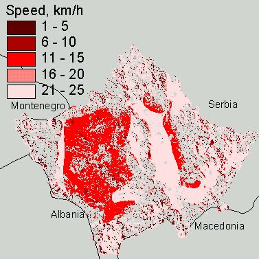
Figure 2. Off-road speed grid in North-South direction.
The road network analysis in probable invasion directions is performed by the ArcView Network Analyst and uses next data:
- road cover type and width;
- road slopes;
- road orientation in relation of probable invasion direction;
- road facilities (bridges, tunnels, intersections etc.) and their parameters;
- dangerous road parts (bottle-necks, abrupt acclivity, forest road etc.).
As a result the most probable invasion routs were defined.
The determination of the possible prohibition zones in probable invasion directions uses next data:
- dangerous industrial facilities;
- hydraulic engineering facilities (water storage basins, piers, banks, weirs etc);
- relief;
- vegetation types;
- hydrography;
- hydrometeorological conditions and season.
As the result possible prohibition zones (flooding, contamination etc) unsuitable for troops motion are defined.
The calculating of probable intensity and density of invasion forces transport flowsare calculated as off-road, network and prohibition zones analyst summary in generalized complex criterion. Resulting grid calculated with this criterion is used for probable optimum invasion routes calculations (fig.3).
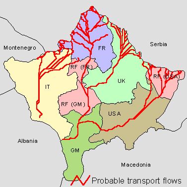
Figure 3. The probable transport flows of the invasion forces.
The offers development on counteraction of the invasion performed on the obtained outcomes base. It makes it possible to define important strategic RMF troop locations for the most effective counteraction of the invasion in Kosovo (fig 4).
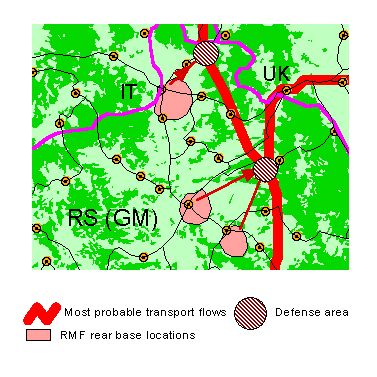
Figure 4. The RMF troop locations for most effective counteraction of the invasion.
In order to avoid the invasion Russian peacekeepers coordinate their activity with KFOR.
In the above-mentioned task GIS software plays a role of integrator and creates complex information data field on terrain, friendly and enemy troops.
The creation of safety conditions for the refugees returning, the possibility of the temporary administrations and the civil presence institutes functioning and the humanitarian help delivery.
The problem of refugees is a key problem in Kosovo now. The government and local authorities politicy produce repeated both Serbian and Albanian population movement back and forth. It makes situation more dangerous, causes death of a large number of people. It is necessary to approach the solution of this problem with large attention and guard
By means of GIS in the "Sentinel" project special maps of refugees movement in a course of conflict development are designed. It allows to track changes of refugees movement, position and condition of their camps, national structure and directions of population flows in Kosovo during the last years.
By ArcView GIS special maps of compact and blended residing of the Serbian and Albanian population in zones of the KFOR responsibility are designed and constantly renovated. The breakpoint line definitions between different nationality compact residing places in Kosovo are also made. The functions of the control over refugees returning, arrangement and operating of local administration, its national structure and measures are designed in the project.
As the result of above-mentioned analysis the zones of a contact of the different nationality compact residing places as sites of a probable tension are defined. It forms the basis for the best patrolling routes definition in a zone of the responsibility, periodicity of patrolling, structure of the patrol, their equipment etc. (fig. 5)
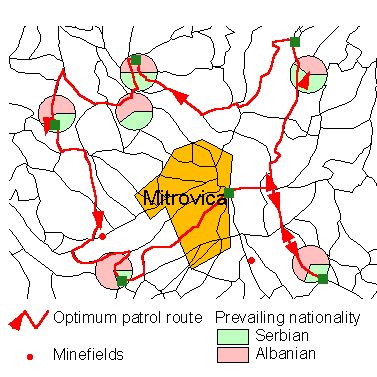
Figure 5. The example of optimum patrol route in the zones between different nationality compact residing places.
Optimization of routes selection takes into account condition of the road network and sites (segments) of roads which is more suitable for enemy ambushes, such as (fig.6):
- bridges;
- tunnels;
- wood part of the road;
- "bottle-necks" segments;
- abrupt acclivity;
- important road facilities etc.
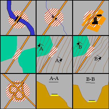
Figure 6. Dangerous road segments.
Optimum selection of the posts locations for people and vehicles movement control in zones of the responsibility is also designed.
GIS are used for the control of fulfillment of the UN schedule on Serbian and Albanian population returning in residing places. The control is implemented by as matching the data about actual and scheduled refugees motion. Besides unplanned outflow of the refugees under pressure of the extremists is fixed, that makes signal for KFOR and RMF on necessity of population protection in the responsibility zones.
In the project "Sentinel" the Esri software makes possible to perform the multilateral and multifactor analysis of states of refugees for the Russian peacekeepers measures optimization of ethnic conflict avoidance and information interaction with KFOR.
The implementation of demining supervision until the international civil presence can not orderly undertake the responsibility for fulfillment of this problem.
The next very important RMF task is implementation of the supervision over terrain, roads and main facilities demining in zones of responsibility.
During the several last years conflict all its participants made mass land, remote and air mining of Kosovo terrain. The mining was conducted by the Yugoslavian army, Albanian extremists, NATO troops and illegal military groups. As a rule anti-personnel and anti-tank mines used in Yugoslavian army were placed. Also because of the engineering ammunition shortage the self-made mines were used. There are plenty of a not burst ammunition - artillery shells, aerial bombs etc as well.
The complexity of a situation is confirmed by group of UN Mine center researchers, who has come to a conclusion that it is necessary about 30 years for full Kosovo demining with available means.
The demining of terrain, roads and objects is not carried out without the RMF as KFOR representative. According to official agreement the Russian peacekeepers have task for direct control of the demining, executed by all participants.
This task includes:
- making the demining schedule and its coordination with KFOR headquarters and UN mine centers;
- organization the information interaction between all participants of demining and control for their activity;
- training people who conduct demining;
- means and stuffs maintenance;
- quality check of the conducted measures;
- organization of explosion-dangerous objects destruction;
- reporting of the conducted activities, definition of warehousing and destruction explosion-dangerous objects places.
In the "Sentinel" project the means which affords broad capabilities for the solving of the demining control problem are designed.
The control of mine situation is possible only if the full information is available. For this purpose the monitoring of mine situation with usage of a different kind of the information: maps, schemes, minefields data cards, reconnaissance results, snapshots processing, data of UN mine centers, etc, is conducted.
On the basis of the obtained information a map of complex mine situation in Kosovo republic is designed (fig. 7).
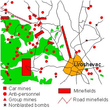
Figure 7.The piece of the complex mine situation map in Kosovo.
With the help of this map the multifactor analysis and number the below-mentioned problems is resolved:
- the calculations of the minefield density in KFOR and RMF responsibility zones (fig.8);
- the complex minefields count;
- the multilateral data exchange with KFOR headquarters, UN mine centers etc.;
- the processing of new information about mine situation;
- the organization of new minefields reconnaissance.
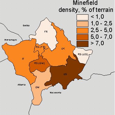
Figure 8.The minefield density in KFOR and RMF responsibility zones.
Activity of Albanian separatists includes ambushes settling, mining of important roads and sites, wired mines placement etc. In the "Sentinel" project ArcInfo 8 is used for definition of the most probable ambushes places, minefields places etc in the RMF zones of responsibility (fig 5.)
As a result of the conducted analysis the best routes of patrolling and movement of the people are determined in order to prevent their transit in places of the probable ambushes. It allows to avoid destruction of automobiles, people death, and also to elaborate the reconnaissance schedule of the probable ambush places.
In interaction with the population in zones of the responsibility GIS is also widely applied:
- warning the temporary administration about mine situation and explosion-dangerous objects in the places of residence;
- marking the minefields and separate mines by signs;
- describing rules of behavior with explosion-dangerous objects, and also realization of practice lessons with the population;
- distribution the special literature, propaganda placards etc.;
- assistance in extreme situations - mine explosions, detection of mines etc.
The "Sentinel" project allows to collect the information about mine danger on unified base, to formalize, to treat and to conduct deep analysis of this information on the basis of the GIS software. The Russian peacekeepers receive the powerful and flexible tool with a broad range of functions for the most effective solution of Kosovo terrain demining problems.
The demilitarization of the Kosovo liberation army (KLA) and other armed groups of the Albanians in Kosovo
At present main destabilizing factor in republic is an activity of Kosovo Liberation army (KLA). Main tasks of a KLA activity are:
- the worsening of the situation in republic;
- receiving the control over the communications, roads, objects, etc;
- expelling the Serbian population from the places of residence for the creation of the Albanian ethnically clean regions.
The task of KLA demilitarization and disarming, suppression activity of the extremists, is assigned to the RMF, as a KFOR part and on the basis of the KFOR schedules.
In the "Sentinel" project the problem of the information control over the KLA activity is solved.
Special maps of the KLA forces disposition, divisions of the Kosovo terrain on zones of the control between different KLA field commanders are designed (fig.9). Besides both collecting and processing data about KLA headquarters and training centers, movement of their formations, their number, field commanders, arms and equipment are carried out.
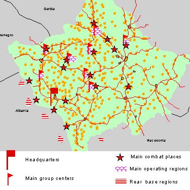
Figure 9. Complex KLA activity map.
In zones of Russian peacekeepers responsibility GIS tools fix next data:
- places of KLA armed offences;
- destroyed houses, churches, objects etc;
- perished, injured and kidnapped people;
- Serbian inhabitants exiled by KLA.
These data allow to conduct correlation analysis on KLA activity, their movements, probable places and directions of operatings. The RMF headquarters receives a capability of a comprehensive estimation of the armed formations activity. ArcView 3.2 has allowed to aggregate all information in a unified place, unified format, that enables to plan effective measures of KLA activity warning and counteraction. GIS tools also allow to organize information interaction with KFOR on KLA demilitarization.
The information interaction with KFOR headquarters, UN mine centers, multilateral data exchange on the Esri software basis.
The main participants of peacekeeping forces in Kosovo, are next the armies:
- USA;
- Great Britain;
- Italy;
- France;
- Germany etc.
KFOR must solve various difficult problems of the peace maintenance in Kosovo. For the first time Russian military troops execute peacekeeping and combat missions together with the NATO armies. Because of the different command systems in the Russia and NATO troops the problem of interaction during the fulfillment of such complex problems is very important.
The complexity of the interaction problem is caused by the fact that RMF has three different responsibility zones:
- In the North (inside of the French zone) - near Lause;
- In the South (inside of the German zone) - near Malishevo;
- In the East (inside of the USA zone) - near Kosovo-Kamenitca;
- In the center (inside of the Great Britain zone) - headquarters near Prishtina.
Thus, the problem of the organization of the effective information interaction between headquarters of the four different language troops has place.
Esri software is selected in the "Sentinel" project for the solution of this problem, as most suitable. It allows to organize the information interaction with KFOR, UN mine centers, local administration etc. The next problems are resolved with the help of it:
- the definition and coordination of joint patrolling routes;
- the control of local population and vehicles passing through the monitoring points and their check;
- the monitoring of the refugees movement according to the UN schedule;
- the monitoring of the Albanian extremists activity;
- the supply of the relevant organizations with the information about demining process;
- Russian peacekeepers activity reports.
It allows to join together efforts of peacekeeping forces in order to solve primary goal - peace establishment in Kosovo.
Conclusions
The "Sentinel" project is a multifunction decision support system for the fulfillment of the Russian military forces peacekeeping tasks in Kosovo . This system is designed on the basis of informational and function-structural models of RMF commander's activity during tasks fulfillment.
At present methods and ways of the ERDAS software application for using in information maintenance of peacekeeping operations are designed in the "Sentinel" project.