The Salt River floodplain, located near Phoenix, AZ was studied using the Hydrologic Engineering Center’s River Analysis System (HEC-RAS) with HEC-GeoRAS. HEC-GeoRAS, a set of procedures, tools, and utilities for processing GIS data in ArcView GIS, was used to assist in hydraulic model development and analysis. Spatially referenced depiction and visualization of flood depths and velocities developed by GeoRAS provided valuable tools for evaluating impacts associated with ecosystem restoration and flood damage reduction alternatives.
Introduction
Geographic Information Systems (GIS) provide a powerful tool for storing, managing, analyzing, and displaying spatially distributed data. However, the benefits derived from using a GIS to assist in hydraulic analysis are often unavailable to engineers not specialized in GIS operation. HEC-GeoRAS is the result of efforts to assist engineers in hydraulic model development and analysis using a GIS.
The development of HEC-GeoRAS has linked ArcView GIS (Esri, 1996) to the Army Corps of Engineers Hydrologic Engineering Center River Analysis System (HEC-RAS). HEC-GeoRAS provides specific access to GIS procedures that assists the hydraulic engineer in the creation and evaluation of hydraulic models using digital terrain data. Providing limited, logical access to a GIS allows the engineer to concentrate on hydraulic concerns, rather than focusing on the complications of applying the GIS.
Benefits achieved using GIS for assisting in hydraulic modeling of rivers systems are demonstrated through the analysis of the Salt River, Phoenix, AZ. HEC-GeoRAS was used to create an HEC-RAS import file, process water surface profile data exported from HEC-RAS, and perform floodplain mapping for several floodplain alternatives concerned with ecosystem restoration and flood control.
Purpose and Scope
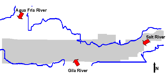
The purpose of the Tres Rios Feasibility Study was to evaluate ecosystem restoration and flood control mitigation measures for the area known as Tres Rios, Arizona. Tres Rios, Spanish for "three rivers", is located in Maricopa County, approximately 14.5 km (9mi) west of Phoenix, Arizona (USACE, 1997). Comprising the confluence of the Salt River, Agua Fria River, and Gila River, the study area is approximately 14.8 km (9.2 mi) long and 1.6 km (1.0 mi) wide. A year-round discharge of 580 million liters per day (153 mgd) is delivered to the Salt River by a waste-water treatment plant operated by the City of Phoenix (USACE, 1999a).
Several study alternatives were developed for improving and increasing fish and wildlife habitat and diversity for threatened and endangered terrestrial species with benefits associated with flood damage reduction, recreation, and water quality. HEC was charged with evaluating alternatives that incorporated ecosystem restoration by providing riparian habitat and flood control by levee. Transmittal of the hydraulic impacts associated with the alternatives and comparison to those existing hydraulic conditions to decision-makers in a meaningful manner was paramount to developing a consensus plan for improving the Tres Rios study area.
Process Overview
The GIS was viewed as the ideal tool to facilitate plan evaluation because of the capability to process and visualize spatial data. Visualization of results would not only assist engineers with modeling efforts, but would clearly communicate conclusions to the numerous decision-makers involved: planners, community members, biologists, and environmentalists. HEC-GeoRAS 3.0 for ArcView GIS was used to assist the HEC-RAS 3.0 hydraulic analysis. A summary of the software used for this study is provided in Table 1.
Table 1. Summary of software used in analysis.
|
Software |
Purpose |
|
HEC-RAS v.3.0 |
Water surface computation program. Steady-flow module of version 3.0 was used. |
|
HEC-GeoRAS v.3.0 |
Pre-processing of geometric data for import into HEC-RAS. Post-processing of HEC-RAS results. GeoRAS is an ArcView extension. |
|
ArcView GIS v.3.1 |
GIS used for processing and visualization of spatially distributed data. |
|
3D Analyst v.1.0 |
ArcView extension. Required use with GeoRAS for TIN processing. |
|
Spatial Analyst v.1.0 |
ArcView extension. Optional use with GeoRAS for grid processing. |
Hydraulic models were developed for existing conditions and several alternative condition scenrios. The existing conditions were evaluated for the base-line conditions. Water surface profiles generated through the GeoRAS process were verified with profiles computed with existing hydraulic models (USACE, 1999b). Alternative conditions were modeled which included increased conveyance and modified roughness coefficients for riparian areas in the main channel and overbanks and a levee on the north side of the river system.
HEC-GeoRAS
HEC-GeoRAS 3.0 is an ArcView GIS extension, cooperatively developed by the HEC and the Environmental Research Institute, Inc. (Esri), specifically designed to process geospatial data for use with HEC-RAS (HEC, 2000a). The extension allows users with limited GIS experience to create an HEC-RAS import file containing geometric attribute data from an existing digital terrain model (DTM) and complementary data sets. The DTM must be in the form of a triangulated irregular network (TIN). Results exported from HEC-RAS may also be processed.
HEC-GeoRAS was used to create a geometric import file for import into HEC-RAS. The import file is an ascii file format containing header, stream network, and cross-sectional information. Information contained in the import file includes river, reach and station identifiers; cross-sectional cut lines; cross-sectional surface lines; cross-sectional bank stations; downstream reach lengths for the left overbank, main channel, and right overbank; and cross-sectional roughness coefficients. Levee alignment information (incorporated in HEC-GeoRAS 3.1) was written to the import file, as well. Water surface profile data and velocity data exported from HEC-RAS was processed for floodplain delineation, inundation depth, and velocity GIS data sets.
HEC-RAS
HEC-RAS is a one-dimensional, water surface profiling program (HEC, 2000b). The HEC-RAS model construct requires definition of the land surface to be modeled and flow data for hydrologic events. The geometric and flow data is used to calculate steady, gradually varied flow water surface profiles (steady-flow module) from energy loss computations. HEC-RAS is capable of modeling a full network of channels, a dendritic system, or a single reach.
Hydraulic Analysis
HEC-GeoRAS was used to develop hydraulic models for the existing and alternative conditions. The alternative scenarios incorporated modification of the channel cross-sectional conveyance and roughness coefficients. For brevity, only one of the alternative scenarios and the 1% chance exceedance flow event are discussed in this paper.
Data Preparation
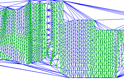
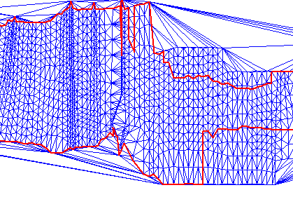
GeoRAS requires the use of a digital terrain model (DTM) in the form of a triangulated irregular network (TIN). The TIN is used for extracting station-elevation data along cross sections, but may also be useful for visualizing the terrain. Due to the fact that the terrain for the Tres Rios study area had braided river channel with little relief, visualization of the TIN was not practical for identifying connected conveyance areas. However, registered digital aerial photography at a 1:2,400 scale were available for the study area and were used to identify the stream network and floodplain.
Several RAS Themes were created in the process of developing the geometric data file for import to HEC-RAS. ArcView themes defining the stream network, main channel conveyance, flow paths, cross-section locations, and levees were developed. A land use theme was available for the study area, and was used to estimate roughness coefficients. These themes were then used, together with the TIN, to develop geometric data for import into HEC-RAS. Themes used for data extraction are listed in Table 2.
Table 2. Summary of RAS Themes used for data extraction.
|
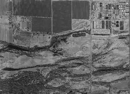
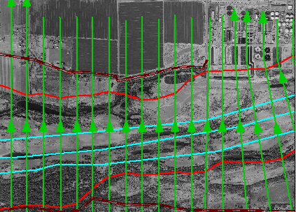
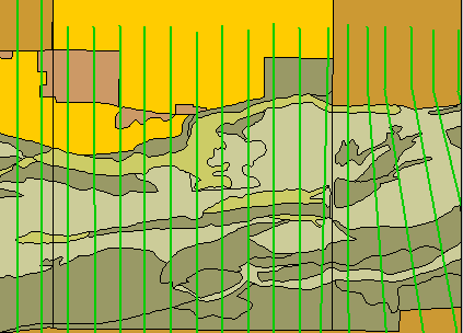
Terrain TIN Elevation data is extracted from the Terrain TIN, but it is also used to locate the floodplain. For the Tres Rios area, a digital orthophoto was available to use a reference for locating the floodplain. Note the waste water treatment plant in the Northeast portion of the photo. The Terrain TIN was modified for the alternative scenario to reflect proposed channel modifications. |
|
|
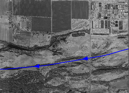
Stream centerline The stream centerline was digitized, using the orthophoto for reference, from upstream to downstream. The stream centerline is used to calculate the river stationing at each cross section. |
|
|
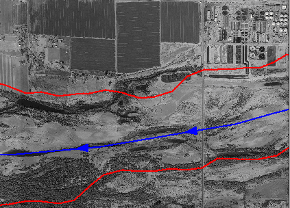
Bank lines Bank lines were located at the edge of the main channel. The bank lines used with the cross-sectional cut lines to determine bank stations at each cross section. HEC-RAS uses the bank station identifiers in the conveyance calculations. |
|
|
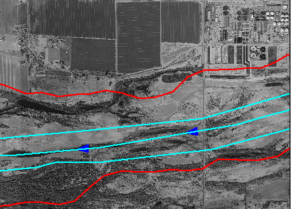
Flow path centerlines Flow path lines are used to calculate the downstream reach lengths in the left overbank, main channel, and right overbank between cross sections. Note in the adjacent figure that the flow path lines are not in the overbank areas. While the lines are not drawn in the correct location (outside of the bank lines) the resultant length is acceptable. We would be concerned if our channel was very sinusoidal. |
|
|
Cross-sectional cut lines The location of cross sections is defined by the cross-sectional cut lines theme. They are digitized from the left to right overbank (when facing downstream). Cut lines should be created perpendicular to flow. Geometric data is extracted using the cross-sectional cut line theme. The data is then appended to the cut lines theme table. |
|
|
Levees Levees were digitized to limit flow in the overbanks behind high ground. The levee information was extracted at each cross-sectional cut line intersected by a levee. The alternative scenerio incorporated a flood control levee in addition to those levees used to represent high ground. This capability has not yet been incorporated into HEC-GeoRAS. |
|
|
Mannings n values Mannings n values were estimated based on land use data. N-values were extracted along each cut line. N-values were modified for the alternative condition to reflect the change in vegetation type in the riparian habitat restoration zones. |
|
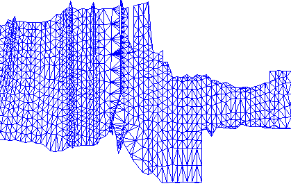
Data were extracted through automated procedure in GeoRAS. The data were appended to the cross-sectional cut line theme before being written to a file for import into HEC-RAS. The cross-sectional cut line theme table is shown in Figure 2. Mannings n values and levee information is stored in separate tables that are linked to the cross section ID (XS_ID) field. The geometric import file is an ASCII file, having a data exchange file format developed by HEC, that contains a header information, stream centerline data, and cross-sectional data.
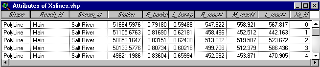
Figure 2. Geometric data appended to the cross-sectional cut line theme.
Data Completion and Model Simulation
The geometric data was imported into HEC-RAS for model completion and simulation. Data imported into HEC-RAS included the stream network and cross-sectional geometry. As shown in Figure 3, station-elevation data, bank stations, downstream reach lengths, Manning’s n values, and levee information were imported for each cross section.
Modification of bank stations and levee alignments was accomplished using the graphical cross section editor in HEC-RAS. Other data that needed completion included bridge data and ineffective flow areas for the Gila River and Aqua Fria River floodplains. Flow data and boundary conditions were also input in HEC-RAS before simulating.
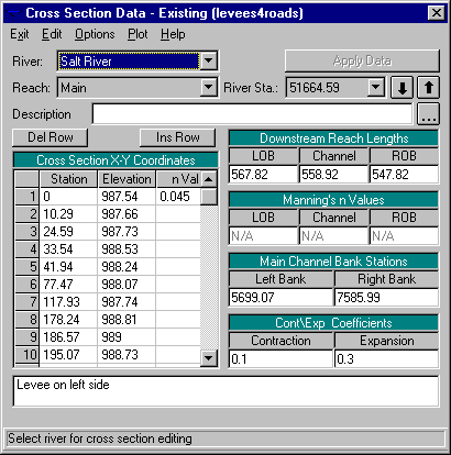
Figure 3. Cross-sectional data as imported into HEC-RAS.
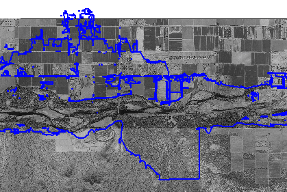
Existing Conditions. Manning’s n values were estimated based on land use. Levee alignments were used to represent roads and connected high ground that prevented flow into the overbanks. Proper levee alignment and bank station positions were achieved by modifying the imported data within HEC-RAS, using the graphical cross section editor. The final geometry, as represented by the RAS Themes, is shown in Figure 4.
The 1% chance exceedance event water surface profile that was computed using the imported geometric data matched well to the calibrated HEC-RAS profile computed by the Army Corps of Engineers, Los Angeles District (USACE, 1999b). Therefore, no calibration or adjustment of n-values was required. Ineffective flow areas, however, were added to the cross sections in the Agua Fria River and Gila River floodplains.
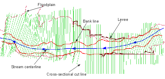
Figure 4. Existing conditions themes.
Alternative Conditions. The riparian habitat and levee construction for the alternative plan was incorporated into the geometric data by modifying the land use data, levee data, and terrain TIN. Location of the proposed riparian restoration efforts and levee alignment are shown in Figure 5.
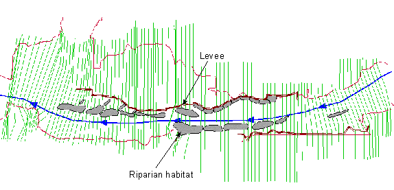
Figure 5. Alternative conditions themes.
Each riparian habitat was incorporated into the geometry by modifying the terrain TIN to reflect the design shape and elevation. The vegetation associated with each habitat area was incorporated into the land use data and new representative Manning’s n values were estimated. All other geometric data were identical to the existing conditions scenario.
Results
Results exported from HEC-RAS were imported into the GIS using GeoRAS. Data exported from HEC-RAS included water surface elevations at each cross section, velocity information at distributed points along each cross section, and bounding polygon information. The bounding polygon information defined the extent of each cross section as modeled in HEC-RAS for the given flow. Floodplain delineation and velocity data were developed which adhered to the bounding criterion.
Floodplain Delineation
Floodplain delineation for each scenario was performed resulting in an inundation depth grid and floodplain polygon. The steps were executed by GeoRAS during the floodplain delineation procedure are summarized in Table 3.
Table 3. Floodplain delineation process.
|
Water surface TIN Cross sections, exported from HEC-RAS and tagged with water surface elevations, are used as breaklines to develop a water surface TIN. This process is independent from the terrain data. |
|
|
Bounding polygon The water surface TIN is then clipped by a bounding polygon. The bounding polygon ensures that only the area that is hydraulically modeled is inundated. |
|
|
Resultant water surface TIN The resultant water surface TIN may be used to identify the water surface elevation at a location independent from the terrain. |
|
|
Inundation depth An inundation depth grid is developed by subtraction of the rasterized water surface TIN and rasterized terrain TIN. The user may specify the rasterization cell size. |
|
|
Floodplain delineation A floodplain polygon is determined by vectorizing the boundary of the water depth grid. |
|
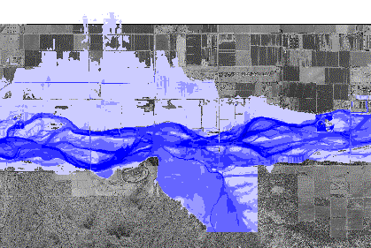
Simultaneous visualization of floodplain delineations and aerial photographs allowed decision-makers to identify acceptable levee alignments. A comparison of floodplain delineations for the existing and alternative conditions is shown in Figure 6.
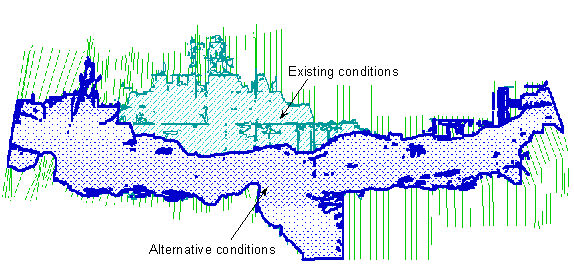
Figure 6. Comparison of floodplains delineated using GeoRAS.
Velocity Analysis
Velocity grids were developed from the cross-sectional velocities. As illustrated in Figure 7, the comparison of velocities between the existing and alternative conditions indicated higher velocities through the excavated riparian corridors and lower velocities in the channel adjacent to the riparian areas.
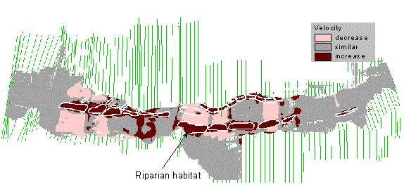
Figure 7. Velocity difference between existing and alternative conditions.
Conclusion
GIS provide a powerful tool for visualizing and processing spatial data. In particular, HEC-GeoRAS provides procedures, tools, and utilities that assist in the development and analysis of hydraulic models by allowing engineers unspecialized in GIS operation to view a "real-world" representation of the system under study. But GeoRAS does not just help engineers focus on engineering concerns, it facilitates communication between decision-makers involved in plan formulation, hydraulic analysis, and public inquiry.
While GeoRAS greatly facilitates hydraulic model development and analysis with HEC-RAS, results must be carefully examined with cautiously drawn conclusions. Identification of errors by visual inspection of hydraulic model results leads to in an iterative process for model refinement.
References
Esri (1996). ArcView GIS: Using ArcView GIS, Environmental Research Institute, Inc., Redlands, CA.
HEC (2000a). HEC-GeoRAS: An extension for support of HEC-RAS using ArcView, User’s Manual, Version 3.0, U.S. Army Corps of Engineers, Hydrologic Engineering Center, Davis, CA.
HEC (2000b). HEC-RAS River Analysis System, User’s Manual, Version 3.0, DRAFT U.S. Army Corps of Engineers, Hydrologic Engineering Center, Davis, CA.
USACE (1997). Tres Rios, Arizona Reconnaissance Report, April, U.S. Army Corps of Engineers, Los Angeles District.
USACE (1999a). Tres Rios, Arizona Feasibility Study, F4 Documentation, June, DRAFT, U.S. Army Corps of Engineers, Los Angeles District.
USACE (1999b). Tres Rios, Arizona Feasibility Study, Technical Appendices, F4 Documentation, June, DRAFT, U.S. Army Corps of Engineers, Los Angeles District.
Author Information
Cameron T. Ackerman, Hydraulic Engineer
U.S. Army Corps of Engineers
Hydrologic Engineering Center
609 Second St.
Davis, CA 95616
Telephone: 530-756-1104
Fax: 530-756-8250