Dr. Rakefet Kol
Abstract
ArcC4I is designed as geotactical components that can be used in building a C4I (Computer, Communication, Command, Control, and Intelligence) system for defense domain. ArcC4I is based on ArcObjects technology. It uses one of the strong capabilities of ArcInfo8 geodatabase, i.e., custom behavior for features and objects. Some of the new concepts developed in ArcC4I enable various dynamic connections between C4I objects, and introduce new Guardian mechanisms. The battle sketches included as part of the ArcC4I are much more than just simple graphic pictures, as they are constructed from “living” objects that can be guarded.
ArcC4I is an advanced toolkit for C4I (Computer, Communication, Command, Control, and Intelligence) application developers. ArcC4I comprises COM components to support the Command & Control process in the battlefield.
ArcC4I was developed based on experience gathered from various C4I systems developed at Rafael and the knowledge of several other defense domain systems. It was observed that all applications for C4I systems share many similar features, and require similar basic components. ArcC4I provides a fast and easy way to develop the next generation of C4I systems. It can be used to develop and integrate a tactical Internet based distributed mobile C4I systems, with the most advanced GIS services and Command & Control capabilities, which meet the requirements of battlefield dynamic behavior.
ArcC4I extends Esri’s ArcObjects technologies. All the rich inherited capabilities of ArcObjects and ArcInfo are used, and some new exciting features are added. ArcC4I consists of COM components that support not only military decision making process, but also plan execution monitoring. Some of the features provided in ArcC4I include support for:
ArcC4I comprises components for handling: forces, units, targets, missions, commands, resources, battle sketches, reports, intelligence information, weapons, etc.
ArcC4I is one of the most important core assets developed according to the Software Product Line development process practiced at Rafael’s C4I systems product line. ArcC4I can easily be extended and configured to match user specifications and needs. Using ArcC4I for developing the next generation of C4I applications reduces development time and maintenance cost. It also improves the quality and time-to-market of the product.
This paper describes some of the new and unique features included in ArcC4I.
Let's take for example a case in which a force is maneuvering in the battlefield and is about to enter an enemy territory. Just in time to save it – the C4I system alerts!
Behind this simple example there is a whole Object Oriented model of C4I system components. These Object Oriented components include situational awareness (with friendly forces and enemy forces), objects representing geographic areas with military significance, a smart warning/alarm mechanism, GIS services, dissemination services, etc. Only some of these aspects are covered in this paper.
The “world” in a C4I system consists of objects such as commands, missions, forces, units, information, battle sketches, targets, sector boundary, ammunition, etc. ArcC4I provides proper components to support all these features and more.
The alert issued by the C4I system in our example is generated by a special watching mechanism (a.k.a. the "Guardian Angel") which is connected to the guarded area and forces, as explained in more details below.
Object Oriented analysis and design is applied in the developing of C4I systems. The Unified Modeling Language (UML) is used for describing the design. The development cycle is iterative, and COM components are developed as core assets according to the Product Line development methodology.
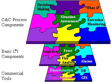
ArcC4I was designed using the n-tier software approach, as can be seen in Figure 1. The lowest tier is based on available commercial tools (e.g., DB, GIS, communication, dissemination). The next tier is a set of basic C4I infrastructure components (e.g., force, logistics, fire analysis, alarm mechanism). The highest tier includes more C4I application type of components to support the Command & Control process (i.e., situational awareness, decision support tools, etc.).
Figure 1 - ArcC4I core assets tiers
Developing a C4I application based on ArcC4I is then just a matter of configuring and integrating the basic infrastructures components of ArcC4I, and adding just the special “add-on”s needed for the specific application (e.g., intelligence officer draft map, firing feasibility check, etc.).
During the development process of ArcC4I we used Visio to describe our design in UML. The model was exported to the MS Repository, and Esri wizards were applied for COM C++ code generation and database schema creation. ArcMap and ArcCatalog were also used during the development cycle.
ArcC4I is based on the Esri's ArcObjects technology behind ArcInfo8, and extends it with specific components needed for a C4I application.
The C4I application data contains geotactical information, i.e. tactical information with geographical info. The geotactical data is considered as just another layers of information in the system. All data is organized in the GeoDataBase which contains vector layers, rasters, DTM, photos, as well as the (friendly and enemy) forces and other C4I items.
Based on the available data, several (simple and complex) queries can be made. E.g., “Which targets move on 3 meters wide roads?”, “Does the planned maneuver cross sector boundaries or rivers?”, “Recommend a post with maximal coverage,” etc.
One of the issues solved by using the ArcObjects technology for the development of ArcC4I is persistency. We need to ensure the continuance of objects at all times, by enabling the saving and restoring of objects. The problem of how to map an object-oriented model to a relational database is basically handled by ArcObjects, and the C4I objects inherit these capabilities.
One of the basic mechanisms applied in ArcC4I is the Accountability mechanism, which is based on the ArcObjects relationship classes. The Accountability enables the connection of two C4I objects, such that an object can be notified upon a change in the connected object. When a related object changes, the connected object is notified, and can act accordingly. The notification across an Accountability can be dynamically enabled or disabled.
We based our development on Esri’s ArcObjects technology, and extended it with C4I objects and features, as described in Figure 2. Simple C4I object and C4I feature inherit Esri Classes object and feature, respectively, and implement a proper IC4I_Root interface. These are further extended by the C4I object and feature, which implement the IC4I_RootAcct interface to support handling accountabilities. Trees of C4I objects and C4I features can be constructed by connecting objects with the proper accountability. For example, interconnecting C4I forces via accountabilities of type ‘hierarchy’ can create an “Order of Battle”.
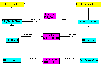
Figure 2 - Part of the ArcC4I extension of the ArcObjects model
Some examples of interconnections dynamically created between C4I objects (using accountabilities) are given in Figure 3. A mission is defined with a target area and a deployment area. A friendly (blue) force is assigned a mission to fulfill (execute). Resources are allocated for the mission. The mission handles specific targets. An enemy (red) force is defined as a target.
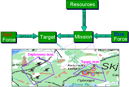
Figure 3 - An example of dynamic interconnectionsbetween C4I objects
Many other examples can be given. Any geometry can be defined as a target, by connecit to a C4I target object.mission can be connected to sub-missions, derived missions, pre-missions etc. A commandformally describes missions, and usually has battle sketches attached to it.
ArcC4I contains a sophisticated warning/alarm mechanism, nicknamed the “Guardian Angel”. It is constructed from several parts, as can be seen in Figure 4. The Guardian is a kind of an observer, which reacts upon event notification (i.e., it is triggered by receiving an indication of an event). The Guardian is connected to either specific guarded object(s), or to a container of C4I items. An expression is evaluated whenever the Guardian is triggered, and an operating strategy is selected according to the evaluation result.
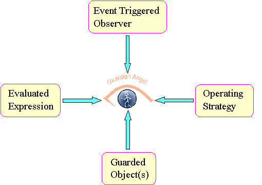
Figure 4 – Basic structure of the “Guardian Angel” mechanism
This general mechanism can be applied in various cases. Several examples of applying the Guardian are given in the following table:
|
Guarded object(s) |
Trigger event |
Evaluated expression |
Operating strategy |
|
A specific Blue force |
Position change |
Crossing sector boundary |
Display call sign and frequency |
|
Any Red force |
Activity update |
Is moving? |
Sound an alarm |
|
Launcher/tank |
Firing |
Which threshold was crossed? |
Order supply, sound an alarm, etc. |
The battle sketches included as part of the ArcC4I toolkit are much more than just simple graphic pictures, as they are constructed from “living” objects that can be guarded. Every item in a battle sketch in ArcC4I is a geographic object, which scales proportionally and can be queried.
Some of the C4I sketch items supported in ArcC4I include forces, boundary lines, mission stage arrows, artillery batteries, posts, etc. All sketches are stored in the geodatabase, and managed by a sketch manager. The C4I sketch items can be connected to each other as well as to any other C4I items in the model.
A sketch can be “activated” and connected to a Guardian, which can monitor events relative to its content (e.g., detect a deviation from a planned axis of movement).
Back again to our example: a force moves and reports its updated location. The info is sent to neighbor forces, commanding force, etc. An enemy force movement is distributed as a piece of intelligence info to all relevant officials. The questions of what needs to be sent, whom to send it to, when to send it, and how to supply an answer to the battle field dynamics, are beyond the scope of this paper.
Other aspects of applying ArcC4I components to C4I processes are also not covered in this paper. These include monitoring mission execution and situation development with regards to the plan, and “what-if” / war-game extension (i.e., if we act in a certain way based on current situation, what will the projected situation be).
This paper describes the design of core assets for C4I systems. It introduces some of the ArcC4I basics, including the Accountability and Guardian mechanisms, and demonstrated their usage.
ArcC4I is an advanced toolkit for developing C4I applications. ArcC4I extends Esri’s ArcObjects technologies. All the rich inherited capabilities of ArcObjects and ArcInfo are used, and some new exciting features are added. Using ArcC4I reduces development time and improves the quality and time-to-market of the product. ArcC4I can easily be extended and configured to match user specifications and needs.
A demonstration of a C4I system that was built using ArcC4I toolkit is presented at the Defense Showcase exhibition at this user conference.
Dr. Rakefet Kol
System Engineer, C4I systems product line core assets group
C4I Systems & Simulators Directorate
Electronic Systems Division
Rafael, Israel
Dept. 84, P.O.B. 2250, Haifa 31021, Israel
Tel: +972-4-8792257
Fax: +972-3-8792268