To access all of this data, staff had to log on to several different databases, some of them not even being available within their own department. Staff was faced with spending time to search for information in many different locations, and some information they wanted was not readily available. To address these issues, the city is now finalizing an automated land records implementation, using NovaLIS� Local Government Office and Parcel Editor products as well as Esri�s ArcView software, which will put city-wide data and GIS on more than 100 users� desktops. Employees will now have access to all their land related information from one GIS-integrated system. There are cost savings in terms of time saved to respond to information requests and to gather information for decision making, but according to city officials, the greatest feature is the ability to access all this information through one system at their desktop, and to have the GIS analysis capability.
Typical Permitting and Map Maintenance Integration
Local government offices process thousands of land use applications and have found that automated management systems can improve their efficiency in processing the application, responding to inquiries about it, and using the information collected to plan for future asset investment. Today�s automated systems strive not to be stand-alone systems, but to integrate with one another to form a corporate data management system, which can be used by staff involved in lands management activities as well as by the broader range of departments. Instead of having a building permit system that assists in processing and issuing permits, another system that tracks subdivisions, and yet another that values these same properties for assessment purposes, all these functions can be collected within one software framework with a seamless flow of information between them, in real time. The benefits of this lack of duplication and the sharing of information among disciplines is obvious and will drive an increasing number of local governments to automated solution such as NovaLIS� Local Government Office.
User Interface
It is critically important that in the transition from paper based to automated systems, that the benefit to the jurisdiction is not obscured to the staff using the system because of increased amounts of work or unreasonable changes to their existing processes. If the current manual system works for the agency but can be enhanced by automation, the agency should try to model existing processes as much as possible, except for those that are made redundant by automation. Therefore, the more that the interface of the software can be tailored to match what existing staff are accustomed to, the earlier the acceptance of the system and the quicker the users will learn the system.
Systems that incorporate tailoring of the interface can use the same land management language that the agency is used to, and can display the data elements that are used as part of an application in the same order and display as they are on their current paper forms. This use of understood language in a familiar form will ease the user�s introduction to the new system.
Another advantage of the tailorable interface is the fact that the data needs of the whole organization can be accommodated by the customization of data fields. The Assessor or the Transportation Engineer may have a critical piece of information to track within a subdivision application and this field can be added to the interface.
Systems with a tailorable interface are also able to edit that interface �on the fly� so that the business process is not stalled for an update. The system administrator can add a new neighborhood to a drop down list, a new data field to the interface or a new type of plan to a pick list. The organization can therefore keep its automated systems up-to-date with its evolving processes, without intervention by software support staff, and, not lose any processing time for the user because the changes can be done without interruption to staff.
Case Scenario
What follows is a typical scenario in a local government that has adopted an integrated approach to data management. In this case, an applicant is requesting a subdivision (split/severance) of one property into three; we will follow the process through application, notification of abutters, approval, update of the digital map fabric and property attributes and distribution of the current information to all users in the jurisdiction.
Subdivision Application
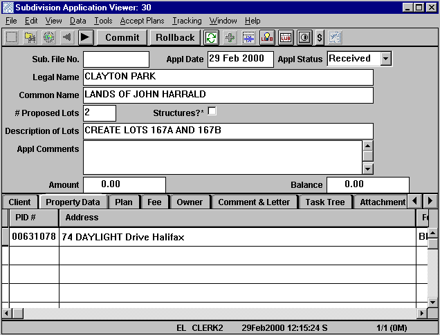
In a typical case, a person will come to the local government office with a set of plans and property information in order to make an application to subdivide a property. The jurisdiction�s clerk will obtain information from the applicant to perfect the application.
Geographic Information System
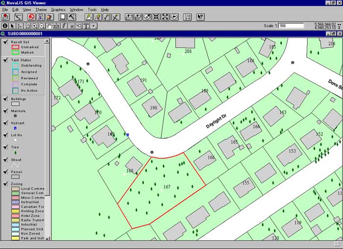
GIS amplifies the power of integrated systems so that they become true data management and analysis tools. At this point in the process, the clerk can �go to map� with the street address or lot number information and display an image of the property to confirm it is the correct one being applied for and also to check the zoning, neighborhood, etc. Integration with GIS enables staff to use a very powerful tool to both provide visual clues about the subject application and to perform in depth analysis about the application. More on this later.
Data Entry
In addition, there are data entry tools that can further speed the taking of an application. Systems can store applicant name, address, telephone, fax, email information and as soon as the first few letters of the company name is entered, all the other information �blows out� to fill in all the relevant fields. This does two things; first, data entry is speeded up and secondly, the information is accurate and is not subject to operator keying error.
The integrated product gives staff access to related databases. In this case, staff could query on the subject property in the property database and issue a �link� command to the system and the information about the property including owner, address, size, frontage, zoning, registry or land titles reference and other relevant information would immediately be linked to the application and would be displayed in the application �view�. Again, significant keying is omitted and in many cases, additional information not normally obtained at time of application is there immediately. Often times, the person reviewing the application would have to research other databases to get that information; now it is available to them immediately.
Finally, drop down lists and pick lists can be used to provide users with a pick from a set of attributes. By picking from the list, the attribute will be correctly recorded and will be properly reported upon through a query or report.
Attachments
The clerk can accept a digital copy of the submitted plan as part of the application too, and attach it to the application in the system. Some staff reviewing the application will have to review the hard copy of the plans; however, for many other reviewers, a digital image will convey enough information to allow a complete review. Attaching digital images, photographs, or scanned documents in other types of applications gives reviewers of the application an available image of the subject application and they may be able to do their review without the circulation of a hard copy plan, and thereby speed processing. Or, a user like an Assessor could query for all applications in the past week and scan through them to get a sense of the types, numbers and location of lots being created in order to plan staff resources for eventual inspection and property assessment.
Commit to the Database
Once the application has been taken completely, the clerk can then commit the application to the database. This does two things. First, the information taken as part of the application is committed to the database and is now available for anyone logged into the system. Therefore, the information is delivered immediately to the rest of the organization and is available as part of their normal work activity. Once other staff begins to do reviews and commit them, this permits other staff reviewing the application to be made aware of what other comments have been made about the application. In this case, the comment of the Transportation Engineer may cause the application to be refused, or at least require extensive changes, so that others reviewing the application can go on to review another until the revisions to the subject application are made. This will save time for all the reviewers.
Workflow
The second thing that occurs is the triggering of workflow activities. The system can be configured so that for a particular type of application, a workflow task is sent out to a list of reviewers. When they log on and query to �get my tasks� the current tasks that have been sent by workflow to them appear on their desktop for review. Nothing lags in the system such that �down time� for the application is minimized. In addition to the quick delivery of these workflow requests, workflow can also act as a management tool, both tracking the volumes of tasks assigned to individuals or workflow �pools� and the time it takes for them to assign them back to the person responsible for approval. It also allows management to reassign tasks when it sees bottlenecks occurring.
Workflow assignment can also include due dates for reviews based on the type of application. By querying on due dates and, in particular, overdue ones, delays in the approval process can be monitored and corrective action taken.
Regulation on Browser
The review of the application is a critical point in the process; this stage has to be done carefully to ensure that all regulations are met to carry out the policy and regulatory direction of the jurisdiction and to only allow development within its growth management controls. The interface used for the application review stage can be similarly tailored as is done for the application view. Additional functionality can be added here to enable review of digital regulations. By hitting a SMART Subdivision Code button, the user is taken to a browser view of the Subdivision Code; this can be customized to go to a particular section depending on what stage of review the staff member is at. By doing this, staff is sure that they are using the most up-to-date version of the regulation document and they can view it from their desktop and not have to shuffle through paper documents.
Query
During the review process, staff will likely need to query for similar properties previously reviewed, or recent approvals in the immediate area to compare this application with them. The tailorable interface allows for any data field to be displayed and the software allows query by any of those fields or a combination thereof. This can be done with a query builder tool, or, can be done right from the interface by entering the search parameters within the respective data fields. This is a very powerful tool that gives unrestricted query ability.
In addition, GIS can be used to enhance the query. The results of a query can be displayed on the map and additional properties can be added to the query by selecting them from the map. The query is sent back to the viewer and the additional parcels are added to the query. The ability to �see� what you are querying on adds a substantial dimension to the development of the result set.
Notification
Process Integration with GIS can play another important and time saving role in the notification process. Many government approval processes require the notification of property owners within a certain proximity to the subject property. GIS greatly simplifies this task. Once the appropriate templates are set up, staff simply identifies the property in question, specifies a radius distance to measure from the subject property to include neighboring properties, has the GIS select the properties, then sends the property owners� names to a word processing merge file to merge these names into a form letter with details about the application imported from the system. What would typically take hours in terms of collecting names and addresses can now be done quickly and efficiently through the use of GIS.
Parcel Editing
Assuming that the application has been approved and that the corporate parcel database can now be updated, a workflow task is sent to the parcel mapping technician to perform this task. In some jurisdictions, this task may start in advance of final approval but for the purposes of this scenario, we�ll assume it starts after approval.
Workflow
The parcel mapper is one of the named positions in the workflow for an approved application. The mappers retrieve their tasks by picking a �get my tasks� item; the subject application details will appear and will give the mapper enough information to identify the appropriate coverage to open to edit.
Split Wizard
Sophisticated editors will use �Wizards,� such as those found in NovaLIS� Parcel Editor, to guide the mapper through the �split� process in a very intuitive interface. The Wizard will step the mapper through the process and also identify exactly where in the process sh/e is. This ensures the integrity of the mapping process, to make sure no steps are missed. It will also allow the mapper to go back through the process if a step should be repeated. The mapper will complete the process after having split the original property into three.

Annotation
The next step is to annotate the new lots. First, the old annotation is deleted. Then, the editing tool is opened to provide functionality for automating annotation entry and placement. Various annotation styles can be predefined with specified level, size, orientation, and position characteristics already set up. Annotation can be done through mass annotation, applying common annotation to a number of features at the same time, or through snake attribution, applying consecutive numbers to a selected series of properties. In this case, the mapper mass annotates by selecting a set of arcs and then picking the �parcel line bearing� mass annotation item and automatically, all arcs are so annotated. The same can be done with lot line length, arc length, etc.
Attribution
Attributes are assigned in both Parcel Editor and Local Government Office in this scenario. The mapper highlights the new lots and moves from one to the next invoking the edit attributes command and enters the new lot numbers from the legal plan. Once that is done, the balance of the attributes will be generated and assigned in LGO.
VBA
Customization Parcel Editor employs VBA so that governments can customize its interface for particular purposes, sometimes unique to the jurisdiction. In this case, the office has added a tool to the toolbar that calls a small VBA program to launch a Parcel Viewer and retrieve the property data for the selected property. The opportunities for customization of Parcel Editor are almost limitless, but common ones are property identifier generators and tax map plot routines. Either VBA or AML can be used to construct these user tools.
Cloning
In the Parcel Viewer, the mapper will now �clone� the parent parcel to create new parcels in the database to hold the attributes for each of the new lots. The cloning process duplicates a set of attributes that are common to the parent and child parcels. This does two things; first, it avoids much duplicate data entry and therefore saves time. Second, by avoiding the additional keystrokes, the risk of error is eliminated.
When the cloning is done, the process generates new parcel identifiers for the new lots and writes them out to a text file for the Parcel Editor to retrieve. Returning to the Parcel Editor, the mapper invokes another custom tool, this time a small VBA program that goes out and reads in the text file and provides an interface for the mapper to place each identifier on the appropriate lot. When saved, the mapper returns to the Parcel Viewer, refreshes and the attributes from the Parcel Editor have been written to the database and the lot area and lot numbers are now displayed.
Corporate Data Update
All that remains to be done now is to update the corporate shape file database, the file that is referenced by all GIS users. Again, this is a user tool that updates the shape files from the editing that has occurred in the Parcel Editor. This is a huge benefit to the organization because almost as soon as the parcel fabric has changed because of the subdivision approval, this change is communicated through the organization via a transaction update; typically, staff waits for parcel updates monthly or even annually. Following the completion of this process, workflow again will trigger next steps for these new parcels. In this scenario, an appropriate workflow would be to notify the Assessor so that new values could be calculated for these lots, new account numbers assigned and an assessment generated. This would mean that all new properties would immediately be assessed and not be missed through a longer update process and that potentially, the tax liability could be collected sooner.
Conclusion
Through this typical scenario, an application has been made, nearby property owners have been notified, staff has reviewed and approved the application and the attributes and parcel fabric have been updated on the corporate database, all through transaction based updates. Because of the integration of the software infrastructure, these changes are able to be disseminated immediately through the organization, such that all users are using current and accurate information that is available at their desktop. Beyond this, the information collected through this process and other similar ones forms the basis of data to use to make decisions for future investment in assets or to make decisions with respect to growth management. This rich supply of data combined with the powerful analysis capabilities of GIS is a strategic tool for management of the public asset base and to inform the general public. Automated systems can make significant improvements to local government lands records management efficiencies. Even greater impact can be made if these automated systems are integrated and combined with GIS. Such systems are available now and can take a jurisdiction to a higher level of service to its constituents.
Bill Campbell
Business Partner Manager
NovaLIS Technologies
Suite 1522 � 1505 Barrington Street
Halifax, Nova Scotia, Canada, B3J 3K5
902-423-1800 ext. 292
902-429-8988
bcampbell@novalistech.com