Three-Dimensional Mapping of Environmental and Prehistoric
Cultural Features
in the Beidha Region
with Spaceborne and Airborne Imagery
Douglas C. Comer, Ph.D.
This paper will appear in the 2000 Annual of
the Department of Antiquities of Jordan (ADAJ), under the title
"Analyzing the Cultural Landscape of Beidha with the Assistance
of Remote Sensing Data:
Some Findings of Relevance to the Chronology of Natufian and Pre-Pottery
Neolithic B Occupations"
Introduction
A cultural landscape analysis was begun by the author in 1999
of the region surrounding Beidha, an archaeological site best
known for its Pre-Pottery Neolithic B occupation, but which also
contains a Natufian component (Kirkbride, 1966; Byrd, 1987). The
analysis utilized radar, multispectral, and photographic satellite
and aerial remote sensing data and imagery; computerized enhancement
and analysis of this imagery; field verification and mapping by
use of global positioning system (GPS) and laser transit equipment
of observed cultural and natural features; interview of local
inhabitants; and a review of pertinent archaeological and environmental
literature. Much of the remote sensing data had been collected
and analyzed since 1997 in collaboration with Dr. Talal Akasheh
of The Hashemite University of Jordan as a part of an ongoing
effort to establish and enrich a geographical information system
(GIS) database for the Petra World Heritage Site. Al Qantara,
a nonprofit research organization affiliated with the University
of Palermo, conducted geological and environmental studies and
mapping with use of GPS in support of this research. Dr. Paolo
Madonia supervised the activities of Al Qantara. The landscape
analysis particular to the Beidha region was conducted with the
support of an American Center of Oriental Research (ACOR) Near
and Middle East Research and Training Program (NMERTP) Post-Doctoral
Research Fellowship.
In this article, some of the findings of the landscape analysis
of the Biedha area are considered in reference to the chronology
of occupation there. The analysis, to begin with, identified factors
that attracted human groups repeatedly to the area during the
Natufian, and again during the Pre-Pottery Neolithic B (PPNB).
There were several, but the one necessary to a combination of
factors that produced a threshold of environemental suitability
for human occupation was level of precipitation. A drop in precipitation
is suggested in this article to be the prime cause for the depopulation
of the area during the Pre-Pottery Neolithic A (PPNA). Other findings
suggest reasons for the human reoccupation of Beidha during the
PPNB as a year round settlement displaying much more complex technologies
and social infrastructures than did the previous occupations there.
Among the factors that produced this complexity was the capacity
for increased agricultural yield associated with the advent of
animal husbandry, and the products of animal husbandry itself.
It is suggested here that animal husbandry at Beidha enhanced
crop yield by providing nitrogen to agricultural soils at crucial
times in the agricultural cycle. Animal husbandry was made possible
by an elaborated socio-cultural organization, with roots in the
PPNA. It was used to control the activities of herd animals, both
to provide fertilization and to prevent animals from destroying
crops. The cultural landscape of the PPNB at Beidha, as it is
described and interpreted in this paper, enhanced the synergy
of plant and animal domestication. The cultural system that harnessed
this synergy flourished and rapidly became more complex. It utilized
the plants and animals that were adapted to the conditions at
Beidha during the post Younger Dryas Climatic Optimum. While this
analysis focuses on Beidha, some of the factors identified by
this analysis regarding cycles of depopulation and repopulation
may have general relevance to site distribution patterns as they
have been observed to change from the Natufian through the PPNB
in the Petra region and elsewhere in the Levant. Before proceeding
with this analysis and interpretations of it, a description of
the method and theory employed here will be given.
Method
Cultural landscape analysis is a method for identifying natural
and cultural features that are relevant to human use of an area,
and to increase understanding of the specific ways in which natural
and cultural features are codetermined. It considers (Comer, 1999):
· Environmental parameters
· Information retrieved through archaeological excavations
and the study of historic sites (and associated documents)
· Traditional use areas
· Current infrastructure (e.g., roads and utilities) and
condition of the landscape
This sort of analysis is greatly facilitated by recent innovations
in remote sensing and geographical information system (GIS) technology.
The analysis depends upon data collected not only through remote
sensing, however, but also by archaeological survey and excavation,
by examination of current infrastructure to see how this might
reflect landscape conditions and be acting to alter landscape
use today, and by investigative techniques taken from cultural
anthropology. The last of these includes the observation and interview
of indigenous populations. Indigenous populations sometimes engage
in cultural practices that derive from or are at least similar
to those of interest to the archaeologist. This occurs when aspects
of the environment and of the cultural practices of interest co-vary
in some of the same ways they did during the past.
At Beidha, aerial and satellite remote sensing of several sorts
was used to discover a variety of natural and cultural features
and zones. These types of remote sensing included:
· SIR-C/X-SAR (space imaging synthetic aperture radar
utilizing bands C, L, and X) apparatus carried by the space shuttle
Endeavour during a 1994 flight over Petra;
· LANDSAT and SPOT multi-spectral imaging satellites
· Elevation data collected from a digital elevation
model (DEM) produced from black and white aerial stereo pairs
by Dr. Talal Akasheh, Dean of Research and Graduate Studies at
the Hashemite University
· Black and white aerial stereo pair photographs, digitized
and incorporated into a GIS for Petra
· Declassified black and white photographs obtained
by Russian and American satellites
· Color photographs taken from a tethered balloon.
Each of these technologies produced graphical images of the
landscape surrounding the village site of Beidha. Each type of
image highlighted or in  some cases revealed
for the first time certain cultural and landscape features. This
work was much facilitated by employing imagery analysis software
(ERDAS IMAGINE). In some cases this required digitizing images
not already in digital form. Landscape characteristics of particular
interest included cultural features, natural features that might
have altered by human occupancy of the area, and natural features,
some of which were key to certain cultural practices. Images were
rectified and coregistered so that they could be superimposed
accurately. Each image thereafter could be used to interpret all
other images. Placing the images into a geographical information
system (GIS) facilitated this interpretation. Each image (coregistered
to all others) constituted a theme in the GIS, and could therefore
be turned on and off to facilitate interpretation (Fig.1 at right).
Further, features identified in the interpretation of images could
be digitized as a separate theme, and selectively turned on and
off.
some cases revealed
for the first time certain cultural and landscape features. This
work was much facilitated by employing imagery analysis software
(ERDAS IMAGINE). In some cases this required digitizing images
not already in digital form. Landscape characteristics of particular
interest included cultural features, natural features that might
have altered by human occupancy of the area, and natural features,
some of which were key to certain cultural practices. Images were
rectified and coregistered so that they could be superimposed
accurately. Each image thereafter could be used to interpret all
other images. Placing the images into a geographical information
system (GIS) facilitated this interpretation. Each image (coregistered
to all others) constituted a theme in the GIS, and could therefore
be turned on and off to facilitate interpretation (Fig.1 at right).
Further, features identified in the interpretation of images could
be digitized as a separate theme, and selectively turned on and
off.
Numerous possible cultural features were noted during this
procedure. Groundtruthing established that many were, in fact,
cultural (e.g., walls, foundations, cisterns). None of these,
however, appear to date to Natufian or Pre-Pottery Neolithic (PPN)
times (with the exception of those already discovered, as with
the excavated site of Beidha), and so fall outside the scope of
this paper. Future analysis of higher resolution radar imagery
may reveal cultural features associated with the Natufian and
PPN periods, such as previously undiscovered below ground habitation
areas.
The procedure, nonetheless, highlighted aspects of the landscape
that were largely formed by natural process, but were important
to the human occupation of the landscape. Such landscape features
were both utilized and assigned meanings by human population in
ways that were implicated in the establishment of aggregated human
populations, the development of domesticated plants and animals,
and the development of a permanent, sophisticated architecture
associated with a settled way of life.
Environmental Diversity
Environmental diversity has long been recognized
as a factor in the development of a settled way of life. MacNiesh,
for example, identifies ecological diversity as the first necessary
condition for both the development of a settled way of life and
of agriculture (1992:12). The ecological diversity of the Beidha
region is remarkable. It results primarily from the varied geological
zones of the region, which greatly influenced the development
 of topography, soils, and plant and animal
communities there. Fortunately, geological diversity proved to
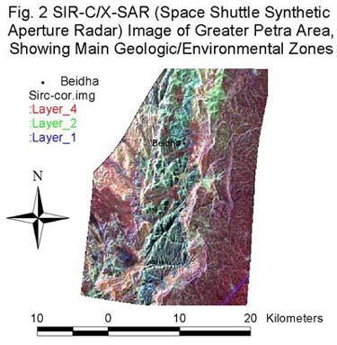
be very clearly differentiated in radar images of the region (see
Fig. 2 for a radar image of the region of Petra). Within these
basic zones, other data and imagery was used to produce characterizations
of relevant environmental and cultural variables. The essential
geological zones, which determine and therefore coincide with
gross environmental zones, which can be seen in Fig. 2 (at left),
are:
of topography, soils, and plant and animal
communities there. Fortunately, geological diversity proved to
be very clearly differentiated in radar images of the region (see
Fig. 2 for a radar image of the region of Petra). Within these
basic zones, other data and imagery was used to produce characterizations
of relevant environmental and cultural variables. The essential
geological zones, which determine and therefore coincide with
gross environmental zones, which can be seen in Fig. 2 (at left),
are:
· The Cretaceous limestone highlands to the east of
the site (seen as the darker, smoother zone occupying approximately
the right third of the image),
· The Cambrian to Lower Ordovician sandstone in which Beidha,
and the Nabataean ruins of Petra, are located (the broad, extremely
rough textured vertical band in the middle of the image), and
· The desert environment of Wadi Araba to the west, where
soils are largely alluvium and wadi sediments, fluvatile and lacustrine
gravels deposited in Early Pleistocene through Early Holocene
times (the band of variegated dark and light, evidently lower
in elevation, that borders the image on the left).
Of particular note is the geographical shelf between the limestone
highlands and the sandstone formation. This shelf is a geological
unconformity, as it is the juncture between two formations that
are very different in age. The Ordovician sandstone is about 450
million years old, while the Cretaceous limestone is approximately
100 million years old. The shelf can be seen in the radar image
as the bright band between the two. It is key to many of the resources
and landscape attributes most important to the nature of the human
occupation of the area at various periods. Associated attributes
especially important to humans include including springs, extremely
high quality lithic materials, a considerable range of elevations,
and the canyons in the sandstone formation that greatly enhance
ecosystem diversity. These canyons were formed by seismic activity
and water flow associated with the unconformity.
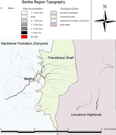 A smaller research area is defined
by the water catchment area for the Beidha village site (Fig.
3 at right). The catchment area was defined by constructing a
hydrological model. This model made use of a digital elevation
model (DEM) produced by Dr. Talal Akasheh, Dean of Research and
Graduate Studies at Hashemite University. The hydrology of the
Beidha region has been of special interest to archaeologists.
Because at present the closest source of water is three kilometers
distant, the location of the springs has seemed problematic to
the placement of the village on the landscape. Archaeological
site distributions models constructed for any area of the world
would find this situation highly anomalous, as often 80% or 90%
or archaeological sites are located within 500 or 600 meters from
water sources.
A smaller research area is defined
by the water catchment area for the Beidha village site (Fig.
3 at right). The catchment area was defined by constructing a
hydrological model. This model made use of a digital elevation
model (DEM) produced by Dr. Talal Akasheh, Dean of Research and
Graduate Studies at Hashemite University. The hydrology of the
Beidha region has been of special interest to archaeologists.
Because at present the closest source of water is three kilometers
distant, the location of the springs has seemed problematic to
the placement of the village on the landscape. Archaeological
site distributions models constructed for any area of the world
would find this situation highly anomalous, as often 80% or 90%
or archaeological sites are located within 500 or 600 meters from
water sources.
Natufian Attractors
By the end of the Pleistocene, with a warmer and wetter climate,
there was much in the immediate vicinity of Beidha to attract
human occupation and to sustain it in high densities. Water is,
of course, essential to human populations, and the hydrological
analysis provides evidence that it could have been present near
Beidha under certain conditions. No springs are now active near
Beidha, and evidence that springs were ever nearby is inconclusive.
The hydrological flow model, however, suggests that water was
present in the canyon during times of high precipitation. Precipitation
and water flowing from the springs can be seen in the model to
be concentrated near the site of Beidha. Precipitation would produce
greater run off, and would also make uphill springs more productive.
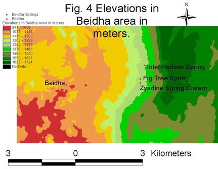 In the region of Beidha, we can
see a dramatic change in elevation to the east of the settlement,
a rise of from about 1,000 meters at the site of the settlement
to a peak of almost 1,700 meters over a distance of less than
five kilometers (Fig. 4 at left). The sandstone canyons in which
Beidha was founded, moreover, provided further environmental diversity.
The aspect of canyons, their precise configuration, and soils
change as one moves away from the limestone highlands deeper into
the canyons produce different microenvironments. This unusually
great environmental variation increased the chances that one of
the econiches in the area would be productive of necessary resources
in the face of overall climatic fluctuations. Environmental variation
also lengthened the harvest season for cereals, which would ripen
at different times in different microenvironments.
In the region of Beidha, we can
see a dramatic change in elevation to the east of the settlement,
a rise of from about 1,000 meters at the site of the settlement
to a peak of almost 1,700 meters over a distance of less than
five kilometers (Fig. 4 at left). The sandstone canyons in which
Beidha was founded, moreover, provided further environmental diversity.
The aspect of canyons, their precise configuration, and soils
change as one moves away from the limestone highlands deeper into
the canyons produce different microenvironments. This unusually
great environmental variation increased the chances that one of
the econiches in the area would be productive of necessary resources
in the face of overall climatic fluctuations. Environmental variation
also lengthened the harvest season for cereals, which would ripen
at different times in different microenvironments.
Environmental diversity is expanded even more as one descends
from the limestone highlands to Wadi Araba. Hans Gebal (1988)
has noted four macro ecological zones in a 20 kilometer transect
from the highlands to the extremely low elevations in Wadi Araba,
which include:
· Swampy environments in the gorges with hydrophytic
vegetation
· Dry desert conditions on the "playa" fillings
with xerophytic vegetation
· Shady gorges (siqs) with more temperate climate
· Water-storing clefts filled with fine sediments
· Intermittent wadis
The essential framework that produces much of this variation
is that observed in Figs. 2 and 3. While many aspects of the landscape
have most certainly changed, some perhaps dramatically, we can
safely assume that the basic geology has not. Combined with an
examination of the geology facilitated by the use of remote sensing,
we can infer with a good deal of confidence certain parameters
of the paleolandscape, such as soils and topography, when these
have been supplemented by on-the-ground observation.
 The network of sandstone canyons
visible in the radar imagery has provided an attractive habitation
area to humans over the millennia. In addition to the environmental
diversity mentioned above, the attractions of the sandstone canyons
included shelter from the extremes of summer sun and winter wind.
Inhabitants have included not only the residents of Beidha, but
also numerous other groups. Perhaps the best known of these have
been the Nabataeans, who built the core portion of the city of
Petra about seven kilometers to the southwest of Beidha, and an
annex of tombs in the canyon just north of the one in which Beidha
is located, about 750 meters distant. This canyon is called Siq
al-Barid, in reference to the cool breezes that are mentioned
today by indigenous Bedouin today as occurring in both canyons.
Most likely these are created by cooler air that slides down the
relatively steep slope along the juxtaposition of the limestone
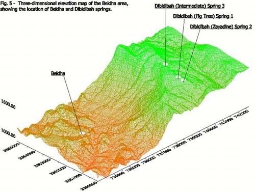
highlands with the sandstone formation (Fig. 5, above right, is
a full, three-dimensional view of the landscape). As the air is
restricted when it enters east-west canyons, wind speed increases
by virtue of the Venturi Effect, which amplifies the cooling effect
of the breeze.
The network of sandstone canyons
visible in the radar imagery has provided an attractive habitation
area to humans over the millennia. In addition to the environmental
diversity mentioned above, the attractions of the sandstone canyons
included shelter from the extremes of summer sun and winter wind.
Inhabitants have included not only the residents of Beidha, but
also numerous other groups. Perhaps the best known of these have
been the Nabataeans, who built the core portion of the city of
Petra about seven kilometers to the southwest of Beidha, and an
annex of tombs in the canyon just north of the one in which Beidha
is located, about 750 meters distant. This canyon is called Siq
al-Barid, in reference to the cool breezes that are mentioned
today by indigenous Bedouin today as occurring in both canyons.
Most likely these are created by cooler air that slides down the
relatively steep slope along the juxtaposition of the limestone
highlands with the sandstone formation (Fig. 5, above right, is
a full, three-dimensional view of the landscape). As the air is
restricted when it enters east-west canyons, wind speed increases
by virtue of the Venturi Effect, which amplifies the cooling effect
of the breeze.
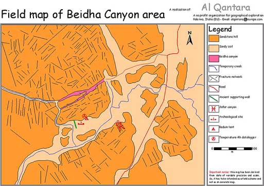 To supplement the macro view of
the sandstone formation, a more detailed geological examination
of the canyon in which Beidha is located was carried out by Al
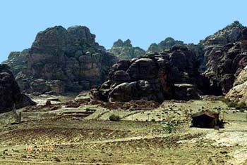
Qantara in November of 1999 and April of 2000. Fig. 6 at left
is a map of the canyon. A Bedouin tent can be seen to be located
just outside the fence surrounding the excavated site of Beidha
(seen also in the photograph at lower right, Fig. 7). Both Beidha
and the Bedouin tent are located on a rise, formed in part because
the location is one of mechanically sound sandstone. Al Qantara
conducted a visual survey of nearby canyons, and noted that the
distribution of Bedouin tents coincides to those areas of the
greatest mechanical soundness of the sandstone (Madonia, personal
communication, 1999). Placing tents in this manner reduces the
likelihood of injury to people or damage to property from falling
rock, as might occur if tents were placed in areas of unsound
sandstone. It also increases the probability that habitations
will be out of the path of flash floods, since elevations of the
canyon floor are higher in areas where sandstone is sounder.
To supplement the macro view of
the sandstone formation, a more detailed geological examination
of the canyon in which Beidha is located was carried out by Al
Qantara in November of 1999 and April of 2000. Fig. 6 at left
is a map of the canyon. A Bedouin tent can be seen to be located
just outside the fence surrounding the excavated site of Beidha
(seen also in the photograph at lower right, Fig. 7). Both Beidha
and the Bedouin tent are located on a rise, formed in part because
the location is one of mechanically sound sandstone. Al Qantara
conducted a visual survey of nearby canyons, and noted that the
distribution of Bedouin tents coincides to those areas of the
greatest mechanical soundness of the sandstone (Madonia, personal
communication, 1999). Placing tents in this manner reduces the
likelihood of injury to people or damage to property from falling
rock, as might occur if tents were placed in areas of unsound
sandstone. It also increases the probability that habitations
will be out of the path of flash floods, since elevations of the
canyon floor are higher in areas where sandstone is sounder.
 Interviews with contemporary Bedouin
inhabitants of Beidha canyon have revealed several other factors
that influence the positions of modern day Bedouin tents. These
include, as might be expected, shelter from the sun in the summer
and from the wind in the winter. Also, the Bedouin today find
it convenient to place tents very near, or within, fields of barley
and wheat they are growing, and among flocks of goats they own.
Such proximity makes the task of managing both resources much
easier. Typically, children are assigned the duty of keeping goats
out of fields of growing grain. This takes a good bit of vigilance,
but the children enthusiasm to this work, shooing goats away from
crops by running at them or throwing pebbles. Failure to keep
goats out of a neighbor's field will occasion a social visit by
the head of the neighbor's family to the head of the family owning
the goats. During the visit, invariably accompanied by tea drinking,
the neighbor will mention that while walking in his fields, he
has noticed the footprints of goats owned by his host. This observation,
made in the course of a friendly conversation, is usually sufficient
to correct the problem. If it does not, the owner of the field
can take legal recourse, for the owner of the goats can be held
liable for damages (Ed-Badbul, personal communication, 1999).
Thus, agriculture and animal husbandry today benefits from the
close proximity of habitation to fields and flocks and ready access
to resources in the canyon, and social convention has become enmeshed
with this organization of cultural and natural features on the
landscape. A similar arrangement in the past, if not certain,
was evidently possible.
Interviews with contemporary Bedouin
inhabitants of Beidha canyon have revealed several other factors
that influence the positions of modern day Bedouin tents. These
include, as might be expected, shelter from the sun in the summer
and from the wind in the winter. Also, the Bedouin today find
it convenient to place tents very near, or within, fields of barley
and wheat they are growing, and among flocks of goats they own.
Such proximity makes the task of managing both resources much
easier. Typically, children are assigned the duty of keeping goats
out of fields of growing grain. This takes a good bit of vigilance,
but the children enthusiasm to this work, shooing goats away from
crops by running at them or throwing pebbles. Failure to keep
goats out of a neighbor's field will occasion a social visit by
the head of the neighbor's family to the head of the family owning
the goats. During the visit, invariably accompanied by tea drinking,
the neighbor will mention that while walking in his fields, he
has noticed the footprints of goats owned by his host. This observation,
made in the course of a friendly conversation, is usually sufficient
to correct the problem. If it does not, the owner of the field
can take legal recourse, for the owner of the goats can be held
liable for damages (Ed-Badbul, personal communication, 1999).
Thus, agriculture and animal husbandry today benefits from the
close proximity of habitation to fields and flocks and ready access
to resources in the canyon, and social convention has become enmeshed
with this organization of cultural and natural features on the
landscape. A similar arrangement in the past, if not certain,
was evidently possible.
It is of special note that goat herding in the canyon would
not be feasible, according to Bedouin engaged in this today, if
it were not for water that is trucked in to supplement water trapped
in a few functional Nabataean water cisterns in or near the canyon.
Periodic deliveries of water are made to these cisterns. The water
is also used for cooking and washing. Wheat and barley agriculture
is at the mercy of precipitation patterns. If a drought period
occurs after grains have begun to sprout, goats are allowed to
consume the dead plants. Goats are also encouraged to consume
plants after the harvest has been gathered.
Herds of wild goats (Capra aegagrus) and the Nubian ibex (Capra
ibex) native to the canyon system comprised a resource crucial
to the Nabataean population of Beidha. Byrd (1989:81) reported
that caprines were the two best represented species in the faunal
collections retrieved during archaeological excavations of the
Nabataean component of the site. The exact percentages of each
species are difficult to determine, because it is very difficult
to distinguish between the bones of these species. (Despite these
anatomical similarities, Capra aegagrus was eventually domesticated
while Capra ibex was not.) The other main large animal species
hunted, the gazelle, was from the steppes and desert of Wadi Araba
(Byrd 1989: 81).
Cereal grains could be found at the high elevations at which
the sandstone and limestone formations surrounding Beidha were
located during the Natufian. Donald O. Henry has noted (1989:
232-234), citing Wright's previous work (1977), that wild cereals
of the sort which supported the Natufian lifestyle were during
the earlier Pleistocene probably to be found only in refuges at
lower elevations. At the end of the Ice Age, with warmer temperatures,
these cereals could be found at higher elevations like those in
which Beidha was located. For reasons that are not entirely clear,
it seems that grain size increased during this period. Warmer
and drier conditions of the Holocene might have produced a selective
advantage for annuals over perennials. He notes also that "annual
grasses and legumes did not appear as significant components of
the vegetation of Asia until the Neothermal, some 11,000 B.P.
[uncalibrated](1977:209)" The larger grain sizes would, of
course, have had the additional advantage of rendering seeds more
attractive for human collection, and subsequent accidental distribution.
For whatever combination of reasons, as Henry notes, there was
only limited exploitation of wild cereals in warm environments
such as the Nile and Rift valleys during the Late Pleistocene.
It was not until roughly 13,000 years ago that evidence has been
found of intensive use of wild cereals, and these, notably, were
in intermountain and piedmont settings. Worldwide, it is remarkable
that the first examples of intensive collection of wheat and barley,
and of rice and maize outside the Levant, occurred in upland settings.
The importance of the upland settings, Henry suggests (1989:232),
might be the fact that seeds matured over a longer period of time,
depending upon the exact elevation that seed bearing plants occupied.
This is to say that environmental diversity of the sort found
in the region of Beidha produced a longer harvesting season.
Brian Byrd, based on the findings of several excavations of
the Natufian occupation at Beidha, considers hunting activities
to have far outweighed grain-collecting activities. He notes,
in fact, very little evidence of processing activities associated
with cereal collecting, much less growing. He reports only two
grinding artifacts: a broken sandstone pestle fragment and a unifacial
discoidal handstone. Other evidence that processing activities
were less common than hunting related activities include low frequency
of nongeometric microliths and a rarity of sickle blades (1989:
76). The only types of features documented during the excavation
of Natufian Beidha were hearths and roasting areas (the latter
associated with large animal bones). No features other than these
were found: no walls, structures, storage facilities, burials,
or stone paving.
In summary, Byrd (1989: 81) considered the Natufian occupation
to be:
…best characterized as a short-term or seasonal camp
site that was occupied repeatedly over a considerable period of
time…It was neither a sedentary settlement nor a highly specialized
field camp or station (Binford 1980), but rather witnessed occupation
by a diverse group of individuals either once or a number of times
for a portion of each year.
He sees this conclusion to fit well within the generally accepted
model of the Natufian annual cycle, which is speculated to have
centered on a sedentary base camp (Byrd 1989:80). Transitory camps,
in the model, are situated around it in a radiating manner (Henry
1985, Bar-Yosef 1983).
The formation of the sandstone canyons began with seismic activity
that produced massive cracks that were later widened by the action
of flowing water. Seismic activity is consistent with the juxtaposition
of the sandstone and limestone geological areas. The sandstone
formation is Ordovician (ca. 450 million years old). The faults,
and seismic activity, began when the limestone was formed, much
later, during the Cretaceous Period (ca. 100 million years ago).
The water that widened the canyons came not only from precipitation,
but also from springs that occur near the fault line. The springs
occur here because water can migrate quite well through limestone,
but not as well through sandstone. Water encountering the sandstone
would then weep, change direction, pond, or perch.
In addition to creating springs, this hydrological dynamic
produced extremely high quality flint formations. Water passing
through the sandstone picked up silica, which was deposited where
water flow speed changed, that is, at the interface between the
limestone and the sandstone. Flint was deposited in large amounts.
As the flint formed, it, too, provided an impervious surface,
which also promoted the formation of springs where it even more
efficiently blocked the path of water percolating through limestone
(Paradise, personal communication, 2000).
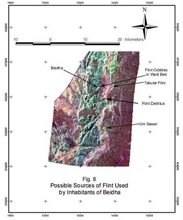
Field observation and remote sensing imagery provide data
that support this model of flint formation. Although not found
as a continuous stratum, flint is plentiful at the juncture between
the sandstone and limestone formations. As seen in Fig. 8 at left,
tabular formations have been noted near the springs above Beidha
(Kirkbride, 1989:121). Flint cobbles are common in the dry wadi
beds in the canyon in which Beidha is located, having washed down
from these formations. Large quantities of flint detritus can
be found in ephemeral stream sediment near Umm Seyhoun (where
Bdul Bedouin whoa one inhabited Petra have been relocated). An
enormous area of flint has been exposed atop a hill in the highlands
to the south of Petra, just above the town of Taybet. This area
can be seen quite clearly in the radar image of the Petra region.
The sources are all associated with the unconformity between the
sandstone and the limestone. The flint produced extremely effective
hunting and animal processing tools, as well as efficient tools
for cutting and shaping a variety of materials.
The Neolithic Landscape
Thus, the juxtaposition of the two geological formations generated
two of the resources most necessary to the cultural developments
at Petra: water and flint. In the transition to agriculture, the
flint was shaped into the microliths that were hafted onto sickles
used for grain collection. Production of fine tools of this sort
required especially high quality lithic material. Suitable material
was surely highly prized, and the flint at the discontinuity would
have been a powerful attraction to populations who had already
developed the agriculture/animal husbandry package.
It is interesting to note that collecting grains by harvesting
with sickles may have hastened domestication of cereals by selecting
for grains that were attached to stalks by less brittle rachises.
Grain that stayed attached to the stalk during harvesting by sickle
or by pulling the plant up by the roots was more likely to be
planted, grain that fell off during collection was more likely
to be consumed by birds or rodents. Bruce D. Smith summarizes
arguments for this in his recent publication about the emergence
of agriculture (1998:72-74). He reports on research by Gordan
Hillman and M. Stuart Davis, who estimate that only three centuries
would have been sufficient to produce the morphological changes
in emmer and einkorn wheat and in barley that are associated with
domestication. He also notes studies by Mordechai Kislev, who
estimates that 20 to 200 years would be enough to make seeds attached
with durable rachises dominant among plants in fields harvested
with sickles or by pulling up lands by the roots.
The high quality flint at Beidha may, then, be implicated in
the domestication of the barley that was native to the area in
the Pre-Pottery Neolithic (Kirkbride, 1989: 120). The flint, because
it could be effectively and efficiently worked into microliths,
encouraged the use of sickles for harvesting. Using sickles for
harvesting produced a selective advantage for barley plant characteristics
that made agriculture an increasingly attractive and viable way
of life. Kirkbride wrote in 1989 that most of the botanical material
she recovered was from the earliest level with permanent buildings
(Level VI) was barley. Carbonized plant remains and imprints in
clay roofs and walls established that Hordeum spontaneum, the
wild, hulled 2-row barley, was being cultivated. She could say
at that time that, "This cultivation of wild cereals is a
stage in the process of domestication that was known of theoretically,
but had never yet been demonstrated in the field" (1989:
120).
To the east, the limestone provided a habitat for animals and
plants of different sorts than found in the sandstone canyons.
It also provided nutrients that were important to the health of
grains growing wild, or later cultivated. These nutrients were
potassium and phosphorus. (Phosphorus is also produced by human
and animal occupation of an area.) The minerals were carried into
the sandstone canyon area by flowing water. The presence of ample
quantities of potassium and phosphorus throughout the interface
are of the sandstone and limestone formations is demonstrated
in Figs. 9 and 10 (below), which shows the results of soil tests
for these minerals on samples taken at six points within and outside
the canyon system.
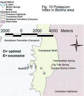
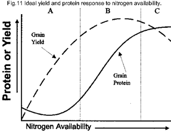 Potassium and phosphorus supply
two of the three nutrients most essential to the health of plants.
The third is nitrogen, which is not supplied by geological formations,
but is extracted from the atmosphere by organisms, and so placed
in the soil by organic materials. It is likely that droppings
from goats living in the canyon supplied enriched the soil there
with nitrogen. It is reasonable to speculate that higher goat
populations and densities associated with animal husbandry would
have resulted in even greater nitrogen enrichment. The importance
of nitrogen is illustrated by Fig.11 at right, which shows how
not only yield, but also protein content in wheat increases as
nitrogen is provided to the wheat plants.
Potassium and phosphorus supply
two of the three nutrients most essential to the health of plants.
The third is nitrogen, which is not supplied by geological formations,
but is extracted from the atmosphere by organisms, and so placed
in the soil by organic materials. It is likely that droppings
from goats living in the canyon supplied enriched the soil there
with nitrogen. It is reasonable to speculate that higher goat
populations and densities associated with animal husbandry would
have resulted in even greater nitrogen enrichment. The importance
of nitrogen is illustrated by Fig.11 at right, which shows how
not only yield, but also protein content in wheat increases as
nitrogen is provided to the wheat plants.
The presence of the goats, however, was something of a double-edged
sword in regard to grain crops. While goats do fertilize soils
in ways that are beneficial to plants, they also devour the plants,
a problem that becomes greater as populations and densities increase.
Thus to maximize the benefit of the potentially beneficent synergistic
relationship between plants and goats, human intervention was
needed. Sustained human intervention required that cultural mechanisms
be put into place.
 Enrichment
of Soils by Goat Herds During the PPNB
Enrichment
of Soils by Goat Herds During the PPNB
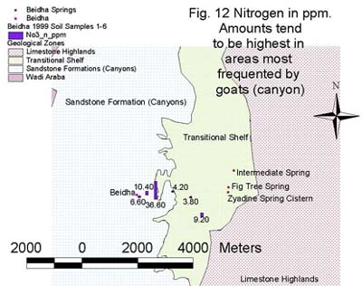
Byrd notes that analyses of soils conducted at Beidha demonstrated
that concentrations of Potassium (P), Nitrogen (N) and organic
matter (OM) were much lower in the Natufian than in the PPN strata.
He interpreted this, in part, as a reflection of the fact that
soil aggradation was occurring during the Natufian, which would
have diluted mineral concentrations. Aggradation had ceased prior
to the PPN, so that materials associated with human occupation
were more concentrated. He also thought it to be another indicator
that habitation was more intense during the PPN than the Natufian
(Byrd 1989:88). It seems possible, though, that it reflects the
high density of the goat population in the area during the PPNB,
as well. A high concentration of goats could have increased concentration
of these minerals at the habitation sites if herds were kept nearby,
as they are today. This would be particularly likely if the habitations
were not just nearby, but positioned within some of the fields,
as is the case with the current Bedouin occupation of the canyon.
The current resulting distribution of nitrogen is demonstrated
in Fig. 12, above left .
Explaining the Discontinuity of Occupation
at Beidha
The findings presented above are relevant to an explanation
of the chronology of occupation at Beidha. The most striking feature
of that chronology is the ample evidence of both a Natufian and
a PPNB occupation, but no indication that the area was the site
of a PPNA settlement.
It is, of course, the case that in the Levant, PPNA sites are
relatively few in number, and remarkable for their large size.
Both Natufian and Pre-Pottery Neolithic B sites are much more
numerous, and occupy a much wider range of environments than do
PPNA sites. It is to date generally held by archaeologists that
this pattern is associated with climatic changes following the
end of Pleistocene glaciation, some of which have been mentioned
above. In particular, the colder and drier Younger Dryas, from
about 13,000 to 11,500 years ago, is thought by many to have rendered
most sites unsuitable for the production of grains in quantities
sufficient to support populations that had grown up during the
Natufian. Therefore, populations practicing agriculture could
occupy only the small percentage of land in the Levant still suitable
for cereal crops during the Younger Dryas. As the Younger Dryas
abated, according to this argument, technologies sharpened by
necessity during the PPNA were put to use in a more widespread
distribution of environments suitable for agriculture. The specific
environmental situation in which Beidha is located and the chronology
of occupation there support the above scenario. They also suggest
additional dimensions to it.
To summarize the Natufian occupation of Beidha, it was, by
all evidence, one that was seasonal and based in hunting. As noted,
the archaeological excavation of the Natufian occupation recovered
no botanical remains and almost no artifacts definitely associated
with cereal harvesting or processing. In contrast, a great deal
of material associated with hunting, especially of caprines, and,
of these, especially, Capra aegagrus, the wild ancestor of domesticated
goats (Capra hircus aegagrus), was recovered. About this period
at Beidha, Bruce D. Smith has written (1998:81):
The spread of cereal cultivation between 10,000 and 9,000 B.P.
[uncalibrated] was by no means universal or everywhere alike.
Well-watered settlements adopted the combinations of cereal crops
that best matched their distinctive hunting-and-gathering economies,
while settlements in less favored settings, such as Beidha in
the southern Levant, continued to rely exclusively on wild plants
and animals.
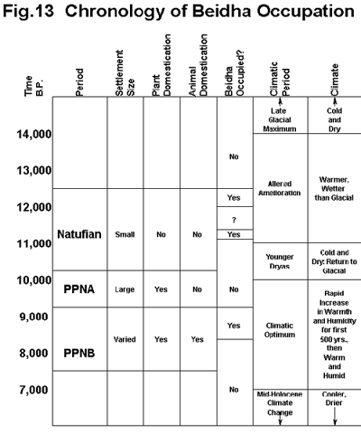 The PPNB reoccupation
of Beidha occurred 2,000 years after the first. According to the
chronology reconstructed in Fig. 13 at right, this was just after
the 500-year interval of marked and rapid warming and increased
precipitation that followed the close of Younger Dryas. Thus it
would seem that the site was reoccupied precisely when the climate
again became very hospitable to the plant and animal species exploited
by the Natufian occupants. The second occupation, however, was
much more complex. As recently as 1998, E.B. Banning said of Kirkbride's
excavations at Beidha that they "…provide the best glimpse
we have to date of a whole PPNB village" (1998:194). Among
other characteristics, Beidha, although small, displayed an array
of sophisticated architecture that bespeaks of social and cultural
complexity.
The PPNB reoccupation
of Beidha occurred 2,000 years after the first. According to the
chronology reconstructed in Fig. 13 at right, this was just after
the 500-year interval of marked and rapid warming and increased
precipitation that followed the close of Younger Dryas. Thus it
would seem that the site was reoccupied precisely when the climate
again became very hospitable to the plant and animal species exploited
by the Natufian occupants. The second occupation, however, was
much more complex. As recently as 1998, E.B. Banning said of Kirkbride's
excavations at Beidha that they "…provide the best glimpse
we have to date of a whole PPNB village" (1998:194). Among
other characteristics, Beidha, although small, displayed an array
of sophisticated architecture that bespeaks of social and cultural
complexity.
As shown in Fig. 13, the correlation between climatic episodes,
cultural periods, and the dates at which Beidha was occupied seems
very clear (the chart is a composite of dates taken from a variety
of sources: Bar-Yoseph and Belfer-Cohen, 1992: 21-24; Birks and
Ammann, 2000:1391-1393; Steig, 1999:1485-1887; Bar-Yoseph and
Meadow, 1995: 44-45; Gebel, 1992: 86; Simmons, 1997:314). The
current landscape analysis suggests the principal reason for this.
Beidha depended upon most of its water from two sources. These
were the few, and currently somewhat meager, springs located upslope,
along the geologic unconformity between the sandstone and limestone,
and precipitation. While minor weeps in the sandstone (caused
by the interface of different types of sandstone) might have occurred
at various times in the past, as they do now (Paradise, 2000:
personal communication), they would probably have contributed
only a small percentage of the total water available to the various
forms of life inhabiting the canyon in which Beidha is located.
Water from precipitation would benefit cereals and other vegetation
that was exploited by humans. Water from both precipitation and
the springs (which would have flowed more freely during periods
of heavier precipitation) would be channeled past Beidha, according
to the hydrological model seen in Fig. 3. Abundant precipitation,
then, would have brought a dependable source of water for humans
occupying the canyon and the animal and plants species there that
were being exploited by the humans.
The presence of a dependable source of water at certain time
periods might explain how it happens that the inhabitants of Beidha
during both the Natufian and the PPNB so heavily exploited the
Bezoar goat (Capra aegagrus or Capra hircus aegagrus). Bruce D.
Smith regards this as anomalous. Smith places the native range
of Capra aegagrus somewhat to the north of Beidha (1998:59). He
goes so far to suggest that hunters at Beidha "…may
well have been killing ibex rather than goats," noting the
difficulties in telling the differences between bones of the ibex
(Capra ibex) and Capra aegagrus. Smith makes this statement despite
the fact that Kirkbride was quite sure that most of the caprine
bones she recovered were Capra aegagrus. As Smith also notes,
however, "…it is not yet clear how far the range of
the wild goat extended south into the Levant. The southern, more
arid portion of this region was inhabited by the wild ibex (1998:58)"
Thus the explanation for this anomaly might be that goats ranged
further south at times of heavier precipitation. The combined
attraction of the goats and flowing water, especially when put
alongside the other attractors mentioned above, were evidently
enough to act as a catalyst for the Nabataean occupation at Beidha.
When precipitation decreased with the advent of the Younger Dryas,
the Nabataean occupation of Beidha ended. Quite likely this was
because the water and the goats in the canyon had disappeared.
Package and Punctuated Equilibrium
Human habitation was reestablished at Beidha when precipitation
regained high levels, about 500 years after the start of the Climatic
Optimum. There is strong evidence that some of the cultural complexity
evident in the PPNB occupation of Beidha developed there. In the
PPNB component of the site, cereals were found that were being
cultivated, including barley in a state of transition from its
wild form, and emmer wheat. The hulled, two row Hordeum spontaneum
was recovered from the earliest PPNB levels. This would strongly
indicate that native barley was being harvested at Beidha, not
domesticated cereal that had been brought in from elsewhere. Similarly,
Dexter Perkins, who conducted the analysis of the faunal material
recovered by Kirkbride, considered that "…the Madamagh-Beidha
faunas strongly suggest that goats were domesticated at Beidha
during the Neolithic," (1966:66). He identified the species
domesticated as Capra hircus aegagrus. Another highly visible
change was in habitation type. The round and relatively irregularly
shaped structures of the lowest levels at Beidha (Levels VII-V)
change by steps into the more regular, strictly rectilinear structures
of Level III.
The agriculture/animal husbandry package that underlay this
rich complexity, however, is probably best thought of not so much
as a set of plant and animal species associated with permanent
architecture as a cultural system. As I have argued elsewhere
(Comer, 1996), cultural systems are based in habitual ways of
regarding, maintaining, and manipulating the world. They include
social controls held in place by groups in society that have benefited
from them in the past and expected to benefit from them in the
future. Perhaps most essentially they depend upon repetitions
of behavior patterns in which meanings are assigned to people,
animals, features on the landscape, and, indeed, virtually all
aspects of human experience. Such behaviors tie members of societies
to an imagined world order that is predictable and enduring. These
patterns are tenaciously maintained so that the world can continue
to be ordered in familiar, predictable ways. Typically, they are
reformulated only in the face of a perceived imminent collapse
of the culture.
The cultural package that provided the basis for the second
flowering of human occupation at Beidha had been developed during
the PPNA. Bruce D. Smith notes that agriculture began in the Levantine
Corridor sites with "…a common characteristic-a dependable
source of water for growing crops in the form of a high water
table." The secure source of water they used to "ensure
good harvests from species they had moved down from their natural
habitats on dry slopes at higher elevations." A prerequisite
of this kind of transport of crops is at least a prototypical
cultural package of the sort described in the paragraph above.
He argues that a dependable source of ground water was the common
variable at PPNA sites (1998:74).
The other major economic component of the full agriculture/animal
husbandry package was the domestication of goats. In a recent
publication, Zeder and Hess argue that domestication of the goat
first occurred in the Zagros Mountains of western Iran some 10,000
years ago (calibrated) (Zeder and Hess 2000 pp. 2254-2257). Yet
is important to note, with Bar-Yoseph and Meadows, that, "In
the Near East…where we have our earliest evidence for the
domestication of food species, there is no site known in which
the herding of domestic animals can be shown to have taken place
without the population having had access to cultivated plants"
(1995:83).
I would suggest that this observation provides an important
clue to both the way in which the agricultural/animal husbandry
package was formed, and the environments to which it most easily
spread. All cultures integrate the landscape into the sort of
imagined world order mentioned above. Landforms are scenes of
the mythological exploits of the ancestors and gods. Directions
are ideologically significant. This integration becomes more complex
and elaborate as the behavior sets associated with agriculture
are adopted. The organizing principal for all cultural systems
is kinship, real or fictive. Meanings assigned to the landscape
and the beings that inhabit it, including animals and plants,
are conflated with the kinship system. Thus we have totems, clans,
and other social units that are tied in the thinking and in the
practical conduct of everyday life to the human relationship with
the landscape. These culturally defined units regulate human behaviors
in ways that are needed to coordinate the tasks necessary to any
economy. In a society supported by agriculture, they regulate,
for example, sowing and reaping, land use, processing and storing
grain, and ways in which the harvest is shared. These sets of
prescribed and proscribed behaviors can, with not much modification,
provide a good structure for animal husbandry, as well. They could,
for example, organize the movements of domesticated animals through
the landscape in a way that would complement agriculture. The
rewards would have been enormous. Increased agricultural productivity
would be one of them. Reinforcing these behaviors would have been
the milk and the materials for making tents, clothing, rope, and
other useful items that cannot practically be obtained from herds
of wild animals.
PPNB sites have yielded striking artifacts that are associated
with the complex ideological structure that developed with the
agricultural economy. These include plaster skulls, plaster figurines,
and even architecture itself. The last of these clearly reflects
and reinforces a more complex social partitioning. It seems likely,
as noted, that the basic cultural structure for this developed
in the PPNA, although it was quite surely elaborated in the PPNB.
A credible scenario is that the PPNB occupation at Beidha is an
example of something like a cultural version of what Stephen J.
Gould calls "punctuated equilibrium" in biological evolution.
According to this theory, environmental change can open econiches
in which organisms that are appropriately preadapted will opportunistically
and rapidly evolve further. When precipitation once more reached
high levels, Beidha canyon became fertile ground for pre-adapted
agricultural/animal husbandry occupation, which flourished and
evolved there apace, and probably synergistically, with other
PPNB sites. The occupation continued until the lush precipitation
abated, which, at Beidha, removed an essential element from the
PPNB cultural system: water. It is probably not too much to say
that a dependable supply of large amounts of water becomes increasingly
important as cultural complexity rises. The complex culture that
had developed at Beidha in the PPNB could not survive without
it.
Bibliography
Banning, E.B.
1998 The Neolithic Period: Triumphs of Architecture, Agriculture,
and Art. Near Eastern Archaeology 61,4:188-235.
Bar-Yosef, O. and A. Belfer-Cohen
1992 From Foraging to Farming in the Mediterranean Levant. Pp.21-48
in A.B. Gebauer and T.D. Price (eds), Transitions to Agriculture
in Prehistory. Madison, Wisconsin: Prehistory Press.
Bar-Yosef, O. and Richard H. Meadow
1995 The Origins of Agriculture in the Near East. Pp. 39-94 in
T.D. Price and A.B. Gebauer (eds), Last Hunters, First Farmers.
Santa Fe, New Mexico: School of American Research Press.
Birks, Hilary H. and Brigitta Ammann
2000 Two Terrestrial Records of Rapid Climatic Change During the
Glacial-Holocene Transition (14,000-9,000 Calendar Years B.P.)
from Europe. Proceedings of the National Association of Science,
97, 4:1390-1394.
Byrd, Brian F.
1987 Beidha and the Natufian: Variability in Levantine Settlement
and Subsistence. Ph.D. Dissertation, University of Arizona, University
Microfilms, Michigan.
1989 The Natufian Encampment at Beidha: Late Pleistocene Adaptation
in the Southern Levant. Vol. 1, Excavations at Beidha. Jutland
Archaeological Society Publications XXIII:1. Moesgard, Arhus:
Aarhus University Press.
Comer, Douglas C.
1996 Ritual Ground. Berkeley, California: University of California
Press.
1999 Cultural Site Analysis as a Tool for Research and Planning,
an Example from Cape Coast, Ghana. Paper presented at the World
Bank Cultural Site Management Workshop, April 28, 1999.
Ed-Badbul, Ali
1999 Personal communication.
Gebel, Hans Georg et al.
1988 Late Epipaleolithic Aceramic Neolithic Sites in the Petra-Area.
Pp 67-100 in A.N. Garrard and H.G. Gebel (eds), The Prehistory
of Jordan. Oxford: BAR International Series, No. 396, Part 1.
1992 Territories and Paleoenvironment: Locational Analysis of
Neolithic Site Settings in the Greater Petra Area, Southern Jordan.
Pp. 85-96 in Susan Kerner (ed), The Near East in Antiquity: German
Contributions to the Archaeology of Jordan, Palestine, Syria,
Lebanon, and Egypt.
Halbaek, H.
1966 Pre-Pottery Neolithic Farming at Beidha: A Preliminary Report.
Palestine Exploration Quarterly 98:61-65.
Henry, Donald O.
1989 From Foraging to Agriculture: The Levant at the End of the
Ice Age. Philadelphia: University of Pennsylvania Press.
Kirkbride, Diana
1966 Five Seasons at the Pre-Pottery Neolithic Village of Beidha
in Jordan. Palestine Exploration Quarterly 98:5-61.
1968 Beidha: Early Neolithic Life South of the Dead Sea. Antiquity
42:263-74.
1989 The Environment of Petra During the Pre-Pottery Neolithic.
Pp. 117-124 in Studies in the History and Archaeology of Jordan,
Vol. 2. Amman, Hashemite Kingdom of Jordan: Dept. of Antiquities.
MacNeish, Richard S.
1992 The Origins of Agriculture and a Settled Way of Life. Norman,
Oklahoma: University of Oklahoma Press.
Madonia, Paolo
1999 Personal communication.
Paradise, Tom
2000 Personal Communication
Perkins, Jr., Dexter
1966 The Fauna from Madamagh and Beidha. Palestine Exploration
Quarterly 98:66-67.
Saskatchewan Agriculture and Food
1995 Nitrogen Fertilization in Crop Production Fact Sheet. Saskatchewan:
Government Press.
1998 Managing Wheat for Protein Premium Fact Sheet. Saskatchewan:
Government Press.
Smith, Bruce D.
1998 The Emergence of Agriculture. New York: Scientific American
Library
Steig, Eric J.
1999 Mid-Holocene Climate Change. Science 286, 5444:1485-1487.
Wright, H. Jr.
1977 Environmental Change and the Origin of Agriculture in the
Old and New Worlds. Pp.281-318 in C.A. Reed (ed), Origin of Agriculture.
The Hague: Mouton.
Zeder, Melina A. and Brian Hesse
2000 The Initial Domestication of Goats (Capra Hircus) in the
Zagros Mountains 10,000 Years Ago. Science 287: 2254-2257.
Figures and Captions
Fig. 1 Coregistered satellite images
Fig. 2 SIR-C/X-SAR (Space Shuttle Synthetic Aperture Radar)
image of greater Petra Area, showing main geologic/environmental
zones.
Fig. 3 Beidha region water catchment.
Fig. 4 Elevations in Beidha are in meters.
Fig. 5 Three-dimensional elevation map of the Beidha area,
showing the location of Beidha and Dibidibah springs.
Fig. 6 Map of the immediate sandstone canyon system in which
Beidha is located.
Fig. 7 Bedouin tent occupying high ground next to Beidha.
Fig. 8 Possible sources of flint used by inhabitants of Beidha
Fig. 9 Phosphorus content in soils near Beidha.
Fig. 10 Potassium content in soils near Beidha
Fig. 11 Ideal yield and protein response to nitrogen availability.
Fig. 12 Nitrogen in parts per million. Amounts tend to be highest
in areas most frequented by goats (canyon).
Fig. 13 Chronological chart of Beidha occupation.
Douglas C. Comer, Ph.D.
Cultural Site Research and Management
4303 N. Charles St.
Baltimore, Maryland 21218-1054
U.S.A.
dcomer@culturalsite.org
A higher resolution version (with larger illustrations)
of this web page can be found by following
this link.