Science classes are in the midst of a dynamic change. The Kansas Collaborative Research Network uses spatial data for analysis of student-generated data. From the creation of original range maps to plotting sample data from stream monitoring and the effect of environmental change on bioindicators, GIS is altering the way students gather and analyze spatial information. This presentation will explore the application of MapObjects, ArcView IMS, ArcView GIS 3.1, and several ArcView GIS extensions in the K-12 classroom environment.
The basic instructional model of traditional public education has been summarized as a factory-style model of teaching and learning where children are turned out much like a factory product of the 1920's (Callahan, 1964). The ideas of a teacher as the principle source and disseminator of knowledge and students as passive receptors of information with eager young minds are relics of a by-gone past. The recently released National Educational Technology Standards for Students echoed these statements when it described learning in the 1990's as occurring in an "isolated and artificial context, wherein passive learning with a reactive response to a teacher-centered, single sense stimulating environment [occurs]" (ISTE, 1999).
The conceptual approaches we use to educate students about and with GIS have substantially far greater reach than studying any particularly salient aspect of GIS technology. In 1997, Heywood and Kemp voiced this idea by suggesting that instilling values of "life long learning" are far more important than teaching a particular GIS technology. "A significant percentage of GI [Geographic Information] knowledge, particularly as it relates to the technology, becomes outdated within less than 6 months. New GI products, services and ideas are appearing at a rate beyond any one individual's ability to keep track". It is because of this rapid acceleration in technology that we must look to the conceptual underpinnings that foster a solid foundation for learning "about and with" geographic visualization tools throughout a person's life.
Since the 1996 publication of the National Science Education Standards (NRC), K-12 science education reform movements nationwide have been progressing gradually toward a model of instruction that emphasizes a hands-on, research based learning experience in the classroom, typically referred to as scientific inquiry. As a method of instruction, scientific inquiry draws upon an epistemological and learning theory referred to as Constructivism. In it's most reduced form, Constructivism is interpreted in the field of education as a class of learning methods, where learners construct their own knowledge with the aid of a teacher-mentor and resource rich environment. When emphasizing the scientific inquiry approach to learning, students are responsible for forming a research question, gathering background information, establishing research methodology, collecting data, analyzing the results, and drawing conclusions (Hassard, 1992).
For such an elaborate procedure to occur, teachers must be comfortable with science content and investigations, discipline and pedagogical strategies for atypical learning environments, and knowledge of the latest technologies to support the research and its analysis (Jarrett, 1997). This method of teaching is not commonplace, in fact it is a rarity and a teacher who can fully orchestrate these processes is even more unique. It is understandable that a significant pedagogical shift is demanded. To facilitate this new way of teaching and learning, technology has been called upon in many ways. The necessary tools of technology range from Internet access and multimedia applications to data analysis and visualization tools. With classroom Internet access, collaborative research projects are possible, where multiple classrooms and teachers work together to solve a common research question.
Very few collaborative projects overtly use the methods and framework of scientific inquiry. However, it is often online collaborative environments that can reap the greatest benefits from data analysis and visualization tools, particularly tools that concentrate on the spatial relationships of collected data (for example, Monarch release and recovery). Indeed, there are some online collaboratives, such as KanCRN (http://www.kancrn.org), which are beginning to place substantial components of data analysis online, using geographic visualization and image analysis tools.
The KanCRN Collaborative Research Network (KanCRN) is a United States Department of Education curriculum project that attempts to fulfill the vision of national efforts to reform science and technology education. The National Science Education Standards (NRC), the Benchmarks for Science Literacy (AAAS) and the Kansas Science Education Standards, all call for "science for all Americans" and "doing science". Although simple in concept, these two phrases constitute a significant change in the way science is taught. More specifically, the standards call for placing an emphasis on the classroom environment by choosing worthwhile scientific tasks, facilitating classroom discourse, and recognizing a need to increase knowledge and beliefs about science.
Research indicates that using "hands-on, minds-on" activities, investigating a few questions in depth, connecting school science with the everyday world of the student, and allowing students to share and test ideas with their peers are indicators of effective science teaching. KanCRN is creating a research environment in which teachers have the necessary tools, and students can help construct this type of learning environment. Using a collaborative research community that includes researchers, community mentors, teachers, and students. KanCRN uses technology to facilitate the implementation of these standards-based teaching principles. The Internet and various technologies create a learning community that transcends geographic and temporal barriers and allows collaboration throughout the world on meaningful research. Due in part to KanCRN's efforts, over 500 classrooms representing nearly every state and nine countries around the world, engage in online collaborative research.
A Geographic Information System (GIS) is a tool for spatial data analysis. This tool allows for the collection, storage, manipulation, and display of data (Slocum, 1999). Typically, a GIS renders a map-based image where layers represent distinct components or types of information within a common geographic area. These layers can be added in any sequence the user prefers and based upon the data available to the user, analyses or visualization exercises can be preformed on that data. It is these visualizations that possess the greatest benefit to teachers and students in their pursuit of data analysis, particularly data related to environmental and social research.
With the advancement of computer technology, including operating systems and diverse applications, widespread support and adoption of GIS for problem solving and spatial analysis is occurring in many industrial and government sectors. GIS-based conferences, such as that of the Environmental Systems Research Institute (Esri) User conference, proudly declare attendance records exceeding 10,000 people annually. The field of GIS is rapidly encompassing previously disparate fields, incorporating tool and skill sets into a unification of technology and science. GIS supports and enhances remote sensing, computer and information sciences, digital cartography, global positioning systems, image processing, spatial data management, and complex modeling units. Geographic Information Systems are now widely being referred to as Geographic Information Sciences, fully articulating the dramatic shift from a historically isolated computing application to an integrated science. Unfortunately, the promise and prosperity of the GIS has not been as fruitful for education.
Geographic Information Systems and public K-12 education first experienced a unity in 1992 with the publication of a seminole article by Robert Tinker. Tinker's work exposed the possibilities of representing data with digital maps in many curricula. He described the power, flexibility and intrigue that maps offered to 4th, 5th, and 6th grade students studying various aspects of the environment as a part of the KidNet Project. Tinker described the significance of kids "ground truthing" data, whereby students, using a map, verify the attribute data of a map or satellite image. He suggested that these data confirmations make the processes of ground truthing and mapping "alive and immediate, providing motivation� for mastering experimental techniques, and for pursuing detailed investigations of interactions". Furthermore, Tinker noted "GIS software provides a critical link between the immediate and personal level of field observation and global effects and concerns".
In a 1996 study of GIS and K-12 learning, Audet and Abegg corroborated many of Tinker's findings. They offer a few observations key to learning GIS in the classroom, including the ability for teachers to differentiate and hierarchically categorize problem-solving styles of students. They also documented the significant role that GIS terminology and concepts play in the acquisition of GIS skills. They continued by adding "GIS supports problem-solving, but is difficult to predict [consistent achievement]". These findings and others seem to suggest that GIS is, at the proper developmental level, an effective tool for the instruction of students for data analysis.
With this kind of analytic power, we would expect to find GIS in wide spread use. In industry, business and government the use of GIS is rapidly expanding. In education, despite the apparent potentials for student learning, it is not growing as quickly as expected. Survey information from GIS teacher training indicates that time is a limiting factor in the use of GIS as an instructional tool. These teachers identified two primary time-related issues. The first need is for personal time to learn and practice how to do GIS. The second need is for time to carryout GIS-based instruction in the classroom (Bednarz, 1999).
Teachers integrating GIS into their classroom report changes were required in their teaching styles, requiring a shift to some form of project-based or problem-based learning coupled with an authentic, performance-based assessment. Broad, systemic changes that require the development of project-based learning add significantly to the time burden to integrating GIS into the classroom. This level of involvement in development is difficult for classroom teachers to embrace. In addition, there is a need for hardware, software and application expertise in the development of GIS applications that put this kind of work out of reach of most classroom teachers.
In addition, a demographic gulf may still exist in software and adequate hardware for classrooms. The National Center for Educational Statistics reported that by 1998, "51% of instructional rooms [in public K-12 schools] had access to the Internet...approximately six students for every instructional computer" (1998). Furthermore, the Center identified a consistent demographic gap in student access to technology. Where the number of students with free or reduced lunches exceeded 71%, the average student to instructional computer ratio dropped to a staggering 17:1. These concerns have been echoed by a number of other agencies including the National Center for Geographic Information and Analysis and the National Center for Educational Statistics (Palladino, 1998). Similarly, the U.S. Department of Education suggests, "74% of [wealthy] classrooms are connected to the Internet, compared to 39% for the poorest schools" (Dept Ed, 2000; NCES, 2000).
GIS can be introduced into the science classroom at different levels of student involvement. Data can be presented to students in a map-based format to help them observe patterns in nature. At higher levels students can also interact directly with data, using this interaction to create new maps. They can create maps with data they have collected and overlay it with thematic layers, including vegetation, elevation, precipitation, and photography. The technology allows a level of analysis that was previously out of reach for students. In creating a context for data analysis, KanCRN uses the resources of the Internet and shared databases to create spatially significant data set. Since the data comes from several sources, it already has a spatial component creating an ideal opportunity for teachers who wish to integrate GIS into their curriculum. KanCRN supports several research areas providing an excellent context for the spatial analysis of data. This kind of data exploration becomes a rich opportunity for different levels of student involvement leading to student generated research questions.
KanCRN uses an assortment of technologies to delivery GIS to its classrooms. These technologies can primarily be divided into desktop GIS and Internet-based GIS applications. Esri's ArcView GIS is the primary desktop application KanCRN classrooms use for visualizing student-generated environmental and social datasets. Since all data from any KanCRN project can be downloaded with a latitude and longitude, it is relatively easy for teachers and students to create event themes, laid atop base maps of political boundaries, hydrology, and elevation. KanCRN also supplies precompiled ArcView projects with base map data and sample walk throughs for creating event themes.
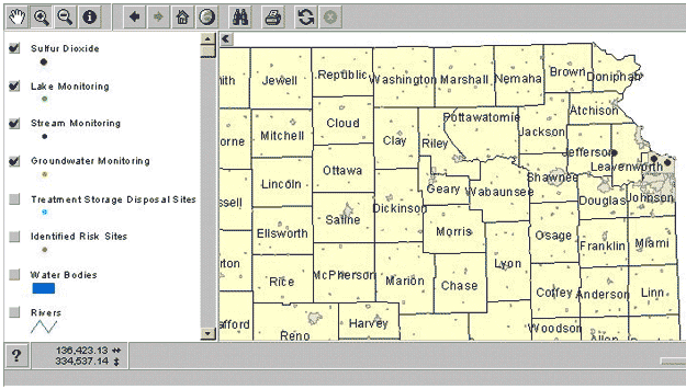
KanCRN has adopted two approaches for delivering Internet-based GIS applications to schools. DASC, the Kansas Data Access and Support Center, in conjunction with KanCRN typically develop rapid-prototype and low-traffic GIS applications with Esri's ArcView Internet Map Server (AVIMS), an ArcView GIS extension. By default, when a user accesses a GIS map created with AVIMS, a Java applet is loaded and compiled on the user's machine via the browser window. Generally, these Java applets allow for users to interact with the map, zooming, panning, and extracting additional map information, with little additional data transfer across the network. The AVIMS software requires that ArcView be running at all times on the server while Internet users are accessing the maps. In order to avoid potential software conflicts and memory issues, KanCRN uses a separate server specifically for AVIMS applications. KanCRN is currently using the AVIMS software to display Lichens and Sulfur Dioxide (SO2) data collected by participating schools.
The Lichens and Sulfur Dioxide (SO2) map of Kansas indicate sampling areas. Each point location could potentially represent multiple SO2 samplings by a KanCRN school or classroom.
For high-traffic GIS applications, a more extensive process is used to develop and manage Internet-based maps. The development environment consists of Microsoft Visual Basic, an object-oriented programming environment for Windows, Esri's MapObjects, a suite of tools that plug-into Visual Basic to add enhanced mapping and web communications capabilities, and Esri's Internet Map Server for MapObjects, an administrative and communications toolset. The MapObjects applications in use by KanCRN typically contains the following components: accessing a remote KanCRN data table, developing the base map with newly generated KanCRN data layers, creating a web-compliant graphic and surrounding web page, and finally returning the page to the user. The MapObjects Internet Map Server software provides administrative-level communication between remote computers that may need to start, stop, or manage mapping applications. The resulting output is a typical web page with a JPEG web graphic and form controls for zooming, panning, and identifying certain features. KanCRN presently uses MapObjects applications in the Ultraviolet Reporting Map, the Kansas Winter Bird Survey Map, School and Citizen Collaboration Maps, and the Stream Monitoring Map.
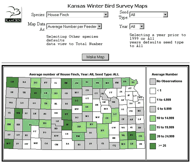
The interactive Kansas Winter Bird Survey Map allows students to determine changes in the patterns of bird distribution across Kansas. Students may examine the total number of birds or average number of birds at a feeder. They may also sort the data either by species of bird, seed type, or year of the survey.
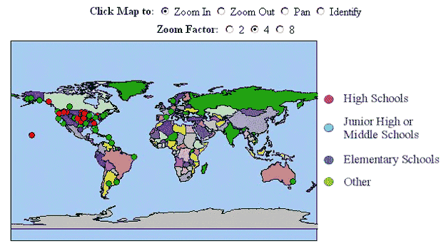
The KanCRN schools map allows teachers and students to visually find and collaborate with others. The map application can provide teacher and school contact information for users. The map is also used when establishing preliminary transects across a region for establishing future sampling locations.
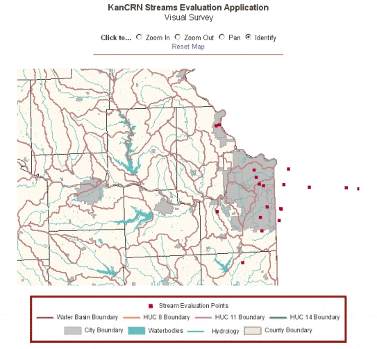
The KanCRN Stream Evaluation Application allows teachers and students to view the biological inventory, water quality index, and visual survey data collected by stream teams in Kansas. The application can provide detailed maps of Kansas hydrology with HUC 14 boundaries.
Historically, maps have been very important to science, but have not been frequently used in the science classroom. It is important to remember that students are exposed daily to printed and television-based maps including weather, demographic and political maps. These map-based presentations have become increasingly sophisticated and often include a three-dimensional representation and a virtual fly-through. It is important that students understand how to view and interpret each of these kinds of representations and how they relate to the physical world.
It is critical to help students along a developmental pathway in using digital mapping in the classroom. A coarse GIS sequence for describing student use or processes is Presentation - Exploration - Analysis - Visualization. This sequence is based on MacEachren's cartography-cubed diagram, a representation depicting how people interact with maps (1994). In this model, each stage represents a point along an advancing continuum of skill and cognition. During any given classroom GIS exercise, multiple levels of the sequence could be used. As students progress in development the activities generally become more individualized, require more interaction, and increasingly use more unknown data with unknown results.
In the classroom, presentation of map-based data should begin by exploring paper maps and data that students see most frequently. The students should be able to look at these maps and describe information shown and perhaps not shown. Local street maps are useful to help students "ground truth" or make a mental connection between the map representation and physical world. A GIS presentation could use layers depicting the local community with roads, rivers, and political boundaries. Using geocoded street networks, students could also add a point on the digital map representing the location of their home.
Exploring maps and the data within digital maps begins to unleash the power of GIS applications. Exploration nominatively suggests that students can control an interaction with the GIS, manipulating, adding, or removing data that is presented. Exploration can include simple queries into the rich data tables underlying the visual representations. With a community map, students may explore it by clicking on a river to get its name or length. Students may decide to add land use or land cover to facilitate the discussion of a neighboring watershed. The Internet-based KanCRN map applications contain datasets highly conducive to map exploration, where the digital maps can be zoomed or queried for extensive information not obvious to the user when the map is simply presented.
Map analysis in the classroom can take a variety of forms. It can begin with students putting an acetate sheet on top of a topographic paper map and tracing out the watershed of a local creek to explore the features found within the watershed boundary. Students can also analyze data by creating maps that look for the most, least or general densities of phenomena. Similarly, students could find phenomena that occur near their home or school, for example, selecting local rivers from a national river dataset. Analysis with a GIS will allow more sophisticated tasks, such as planning the route of a new highway through an environmentally sensitive area or to modeling the spread and effects ground level ozone. Using layers within a GIS and combining a location with the attributes of that place facilitates analysis.
Visualization involves students manipulating the display of the data and exploring different representations that can be made. The students need a high level of skill in cartography, the GIS software, and the phenomena being mapped so that they can accurately alter the visual interpretation of the data. By altering the way the data is perceived, students can begin to look for new, previously unknown trends hidden within the data. Recombination of multiple, pre-existing data layers may also breach into data visualization. Data classification and symbology can also be altered in the search for new patterns. Presenting data in a three-dimensional view and time sequenced animations are also commonly considered to be possible elements of visualization.
By understanding and adhering to such a developmental sequence, creating lessons for student learning becomes far more systematic, setting the framework for a more comprehensive scope and sequence of GIS skill development in the K-12 classroom. Ultimately, this process sequence must be further defined through research, identifying other key stages in the sequence and articulating the process sub-stages that support each stage of the sequence. Once specific skill sets are tied to process sub-stages, an initial curriculum scope and sequence can be established.
All levels of GIS applications for education continue to grow rapidly despite a variety of longstanding barriers. As the industry expands and supporting hardware and software becomes more readily available, it's expected that many of the current obstacles will fade. This will leave a great need for a comprehensive scope and sequence of GIS skills that can be adapted to a variety of traditional and reform-based classroom curricula. The KanCRN project provides both a strong curricular setting for the creation of student-generated research efforts and advanced development environments for analysis and visualization of classroom data from that research. KanCRN GIS applications and supporting curricula provide a rich environment for the presentation, exploration, and analysis of student-generated data sets. It is hoped that in the near future, resources providing far greater research support for such a scope and sequence will be found in academia and industry.
American Association for the Advancement of Science. (1993). Benchmarks for science literacy, New York, NY: Oxford University Press.
Audet, R.H. & Abegg, G.L. (1996). Geographic information systems: Implications for problem solving. Journal of research in science teaching, 33(1), 21-45.
Bednarz, S. W. (1999). Impact and success: Evaluating a GIS training institute. [Online]. Available: http://gis.Esri.com/uc99/PROCEED/PAPERS/PAP895/P895.HTM
Callahan, R.E. (1964). Education and the cult of efficiency. Chicago, IL: University of Chicago Press.
Hassard, J. (1992). Minds on science: Middle and secondary school methods. New York, NY: Harper Collins Press.
Heywood, I. & Kemp, K. (1997). Interoperability for GI Science education:Building a flexible knowledge and resource base. [Online]. Available: http://www.ncgia.ucsb.edu/ige98/whitepaper.html.
International Society for Technology in Education (ISTE). (1999). National educational technology standards for students. [Online]. Available: http://cnets.iste.org/pdf/nets_brochure.pdf.
Jarrett, D. (1997). Inquiry strategies for science and mathematics learning. [Online]. Available: http://www.nwrel.org/msec/book2pdf.pdf
MacEachren, A.M. (1994). Visualization in modern cartography: Setting the agenda. Visualization in modern cartography, ed. A.M. MacEachren and D.R.F. Taylor. Oxford: Pergamon Press.
National Center for Educational Statistics. (1998). Internet access in public schools and classrooms: 1994-98. [Online]. Available: http://nces.ed.gov/pubs99/quarterlyjul/3-elem-sec/3-esq12-h.html.
National Center for Education Statistics. (2000). Internet access in US public schools and classrooms 1994-1999. [Online]. Available: http://nces.ed.gov/pubsearch/pubsinfo.asp?pubid=98031
National Research Council (NRC). (1999). How people learn: Brain, mind, experience, and school. Washington, DC: National Academy Press.
National Research Council (NRC). (1996). National science education standards. Washington, DC: National Academy Press.
Palladino, S. (1998). K-14 GIS: A review of eight years of NCGIA efforts [Online]. Available: http://www.ncgia.ucsb.edu/~spalladi/documents/Esri.html
Slocum, T. (1999). Thematic cartography and visualization. Upper Saddle River, NJ: Prentice Hall.
Tinker, R. F. (1992). Mapware: Educational applications of geographic information systems. Journal of science education and technology. 1(1), 35-48
US Department of Education, White House Press Release. (2000). The importance of bridging the digital divide and creating digital opportunity for all Aericans [Online]. Available: http://www.ed.gov/PressReleases/04-2000/wh-000417e.html