Ecosystem management requires tools which assess the trade-offs among strategic planning decisions. The Tool for Exploratory Landscape Scenario Analyses (TELSA) is a spatially explicit model of ecosystem dynamics. It simulates the impacts of succession, natural disturbances, and forest management activities on stand and landscape characteristics at scales of 10,000 to 200,000 hectares. The model includes custom data preparation and analysis tools for ArcView and the Spatial Analyst. TELSA is currently used in British Columbia, Alberta, and in several states in the western US.
Forest managers are increasingly asked to manage large areas of land to meet various non-timber and traditional timber objectives or to move the areas into a desired future condition. These conditions or objectives are often defined in terms of seral stage distributions, patch sizes, amounts of old growth habitat, as well as timber flow. Many of the non-spatial conditions, such as seral stage or timber flow, can be determined from non-spatial timber management models. Spatial characteristics of landscapes, such as fragmentation, patch-size distribution, and connectivity require spatially-explicit models. Many of these characteristics are largely determined by management actions and their interaction with natural disturbances, and few models represent both processes. The Tool for Exploratory Landscape Scenario Analyses (TELSA) was developed as a spatially explicit model that could combine these processes, including vegetation succession, and that could be used to facilitate landscape-level planning. This paper gives a general overview of some of the capabilities of the TELSA model.
TELSA is a spatially explicit landscape planning tool that is designed to simulate the interactions of vegetation succession, natural disturbances, and forest management activities over time. The model allows users to explore alternative scenarios comprised of assumptions about succession, management actions, and natural disturbances, and the random variation associated with the stochastic components of each scenario. The model operates at the scale of 10,000 to 200,000 hectares, depending on the questions being asked. TELSA is a toolbox made up of eight separate applications which all operate on a central database. The applications are written in a variety of languages, including Avenue, Visual Basic, and C++. All components run on high-end personal computers with Windows 95, 98, or NT 4.0.
TELSA requires spatial information in the form of maps (ArcView shape files). Four types of maps are used in the model:
During the map preparation setup phase, a customized ArcView tool processes information from each of these maps, prepares the maps for later use by the model, and places the relevant information into the appropriate tables in the database.
In the next phase, the Forest Cover Map polygons are divided into the smaller polygons the model will act on. Natural disturbances and forest management activities generally occur at different spatial scales: natural disturbances typically create impacts in a wide range of patch sizes while management actions typically affect a much narrower size range of areas. Two different spatial entities are used by TELSA to represent each of the two processes. Simulation polygons, individually or in groups of varying sizes, are affected by natural disturbances while management units are used to implement management activities in the landscape.
Simulation polygons are the smallest spatial entities on which the TELSA model operates during a simulation. These polygons are created using another customized ArcView tool which intersects the polygon boundaries from the forest cover map, and one or more user-selected planning zone maps. The resulting polygons may be further subdivided using a Voronoi tesselation (Okabe et al. 1992) and user-defined parameters which affect the final size range of the simulation polygons. Details on this process are given in Kurz et al. (2000). The tool creates a new map, and places information about each of the simulation polygons, and their adjacencies, into the main database.
Simulation polygons are of irregular shape, can be of any size, and are the level at which natural disturbances and succession are simulated. A finer tessellation will result in more, smaller polygons and will increase simulation time, memory usage, and required hard disk space, but may make the representation of some disturbances more realistic. Coarser tesselations will create fewer, bigger polygons, and will run faster, but will be unable to produce some small disturbances. Regardless of the tesselation parameters, fine landscape features such as riparian buffer zones, seismic lines, or other linear features in the landscape are maintained through this approach.
Management units are the areas in which a specific activity occurs in the same year, and for which a sequence of activities has been defined. Management units consist of one to many contiguous simulation polygons with similar ecological characteristics and ages. These are created during the second part of the setup phase. The model generates management units by combining the appropriate simulation polygons according to user-defined criteria which specify the size distribution of the units for each set of management activities. While management unit boundaries do not vary during the simulation, natural disturbances will affect the order, the amount, and the type of management activities that are applied to each of these management units.
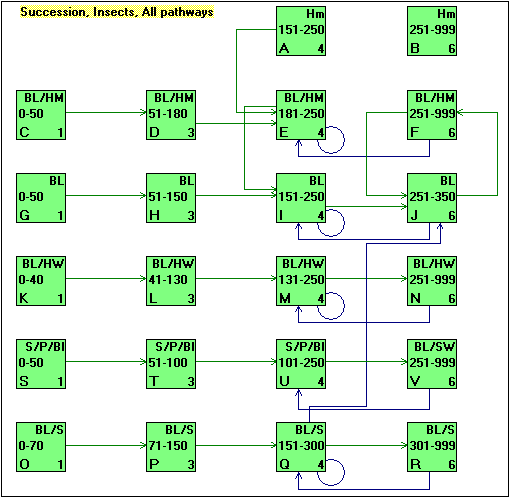
Changes in the landscape are represented as changes in the species composition and structural stage of the simulation polygons. Together, the species composition and structural stage represent different successional classes. These classes are linked using succession pathways which define the transition times between the classes. Other pathways define the probabilities and impacts of natural disturbances such as fire or insects, and the impacts of management activities (Figure 1). These successional classes and pathways can be defined for each ecological stratum that is being used in the model. At the time of initialization, each polygon must be assigned to a successional class from one of the pathway diagrams.
Figure 1: Example vegetation pathway diagram for one ecological zone showing the succession and insect pathways. This diagram was created using VDDT.
The Vegetation Dynamics Development Tool (VDDT, Beukema and Kurz 1998) can be used to create the successional classes and to develop the pathways and probabilities. This process can involve local ecologists, silviculturists, pathologists, entomologists, and fire ecologists, who can contribute information based on their domain expertise into a combined pathway diagram. VDDT is useful for making all assumptions explicit, for testing the results of these assumptions about the different disturbance agents and for providing a common framework for users with different backgrounds. It was originally developed for, and used by, the Interior Columbia River Basin Project (Quigley and Arbelbide 1997). TELSA is designed so that information created in VDDT can be directly imported.
Natural disturbances operate on one or more simulation polygons. The pathway diagrams from VDDT define the probability of each disturbance type occurring. Because TELSA is a spatial model, it also must have information about the expected size-class distribution of each disturbance agent. Users can then, optionally, provide additional multipliers to simulate long-term trends, such as global warming or changes in fire suppression policy, or to simulate annual variation that is independent of landscape conditions, such as annual fire variability due to weather.
Disturbance parameters provided by the user and landscape characteristics are used by TELSA to simulate the spatial distribution and size range of natural disturbances, which in turn affect future landscape characteristics. TELSA simulates the initiation and spread of disturbances using methods that are appropriate for a strategic planning tool. Because weather conditions at the time of future disturbance events cannot be predicted TELSA does not attempt to simulate the details of disturbance dynamics. Disturbances may spread between simulation polygons, management units, ecological strata, and planning zones. They can only affect those polygons that are eligible for the disturbance (Figure 2).
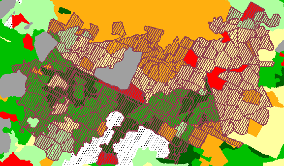
Figure 2: Example of a large fire simulated in the TELSA model. The gray polygon in the middle of the fire was not burned because it was not susceptible to fire. This map was created from the customized ArcView Map Display Tool described below.
Management activities in each time step are simulated based on the current conditions of the landscape. A suite of user-defined management rules is used to determine which management actions are appropriate. For example, salvage logging rules define whether or not to remove timber affected by natural disturbances. Users can also provide information on silvicultural systems, sequences of management activities in various ecosystem types, targets for volume removals, annual limits for all types of activities, various constraints on management activities, road activation and inactivation rules, and various other management rules.
Once all spatial and non-spatial assumptions have been defined, the user can create scenarios for which the trade-offs will be analyzed. A scenario combines sets of assumptions. Thus, two scenarios can be identical except for the assumptions about a specific aspect such as whether or not disturbances are present, or the choice of activity limits, or the choice of planning zones.
Disturbances operate stochastically in their choice of the initial polygon to disturb in each disturbance incident, and in the annual multipliers that can be used. Thus, multiple simulations of the same scenario can be done to explore the range and variability in various indicators.
Once a run is complete, spatial metrics of the simulated landscape conditions can be calculated using a customized ArcView and Spatial Analyst application that uses the results of the runs to calculate the count, size, and area of patches and interior forest habitat (Figure 3) according to user-defined age classes, and, optionally, cover types or planning zones. This application can also produce information about the length of edge between patches of different age classes, and the amount of area affected by roads.
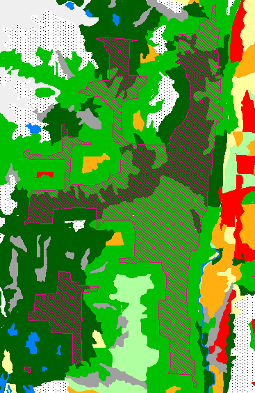
Figure 3: Close-up of a section of a landscape with a patch of interior old growth habitat. The patch is shown by the dark shading, while the background gives the age classes. This map was created using TELSA’s Map Display Tool and overlaying two different types of maps.
The results of the simulations and the spatial analyses can then be reviewed through two interfaces: one that creates graphs and tables, and one that is a customized ArcView application that produces maps (Table 1). These interfaces are designed to allow users to be able to compare the results between runs, simulations, or time steps (Figures 4 and 5). Graphs and tables can be printed or their data can be exported for use in other graphing or statistical packages. Since maps produced are ArcView shapefiles, once a map is created, all usual ArcView options are available.
Table 1: Summary of the types of output that can be mapped or graphed after a simulation. Variables in italics require additional spatial analyses.
| Graphs | Maps | Tables |
| Disturbed area or volume by disturbance or management type | Location of disturbance or management | Total, minimum, maximum, standard deviation, average area disturbed by disturbance or management type |
| Age class distribution | Age class | Static characteristics |
| Seral stage distribution | Volume | Border lengths |
| Size classes of disturbance or management events | Structural stages | |
| Cover type distribution | Cover types | |
| Length of active roads | ||
| Attributes | Probability of disturbance | |
| Area and count of patches | Frequency of disturbance | |
| Area and count of interior forest habitat | Patches | |
| Border lengths between classes | Interior habitat |
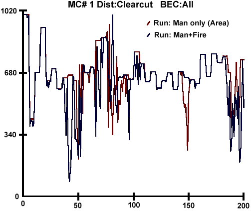
Figure 4: Example of a graph from the Graphing Tool, showing the area harvest with and without natural disturbances.
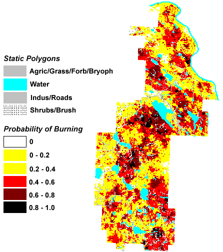
Figure 5: Example of a map created using the Map Display Tool, showing the probability that a polygon will be disturbed by fire.
Because all parameters in TELSA are defined by the user, it can be used in any terrestrial ecosystem type without modifications to the model. Some of the recent applications include: the boreal forest in Alberta, northern coastal forests and southern interior forests in British Columbia, forests in Oregon, and range lands in Idaho. Three of the problems that have been explored recently by model users are:
The TELSA model is not designed to find optimal solutions to problems or to make detailed management decisions. It is a tool for exploring the interactions between natural disturbances and different management alternatives, and their combined effect on landscape metrics. Any map of a future landscape condition is but one realization of the consequences of the assumptions about management actions and natural disturbances, and may not occur in the real world.
We thank the following people for aiding in the design and implementation of the model: Tim Webb, Julee Greenough, Alan Sharpe, Don Robinson, and Keti Milosheva. Thanks also to Russ Walton for testing the model during the development of Version 1. The development of Versions 1 and 2 of TELSA have been funded by a variety of sources including: Forest Renewal BC (www.forestrenewal.bc.ca), BC Ministry of Forests (www.gov.bc.ca/for/), Joint Fire Science Program (www.nifc.gov/joint_fire_sci/jointfiresci.html), ESSA Technologies Ltd. (www.essa.com), and Alberta Pacific.
BEUKEMA, S.J., and W.A. KURZ. 1998. Vegetation Dynamics Development Tool users= guide, Version 3.0, ESSA Technologies Ltd., Vancouver, British Columbia. (www.essa.com/forestry/vddt)
Klenner, W., W.A. Kurz, and S.J. Beukema. (2000). Habitat patterns in forested landscapes: management practices and the uncertainty associated with natural disturbances. Computers and Electronics in Agriculture 27(1-3): 243 - 262.
Kurz, W.A., S.J. Beukema, W. Klenner, J.A. Greenough, D.C.E. Robinson, A.D. Sharpe, and T.M.Webb (2000). TELSA: The Tool for Exploratory Landscape Scenario Analyses. Computers and Electronics in Agriculture 27(1-3): 227 - 242.
Okabe, A., B. Boots and K. Sugihara. 1992. Spatial tesselations: concepts and applications of Voronoi diagrams. John Wiley and Sons, New York, New York, USA.
Quigley, T. M. and S. J. Arbelbide, editors. 1997. An assessment of ecosystem components in the Interior Columbia Basin and portions of the Klamath and Great Basins, Volume II. U.S. Department of Agriculture Forest Service, Pacific Northwest Research Station and U.S. Department of the Interior Bureau of Land Management General Technical Report PNW-GTR-405.
Sarah Beukema, Systems Ecologist and Werner Kurz, Forestry Team Leader
ESSA Technologies Ltd.
300-1765 W. 8th Ave
Vancouver, BC V6J 5C6 Canada
sbeukema@essa.com
wkurz@essa.com
www.essa.com/forestry
Jim Merzenich
US Forest Service
PO Box 3623
Portland, OR 97208 USA
jmerzenich@fs.fed.us
Susan Schilling, Computer Specialist
USDA Forest Service, Pacific Southwest Research Station
4955 Canyon Crest Drive
Riverside, CA 92507 USA
sschilling@fs.fed.us
Mike Arbaugh, Research Ecologist
USDA Forest Service, Pacific Southwest Research Station
4955 Canyon Crest Drive
Riverside, CA 92507 USA
marbaugh@fs.fed.us
Walt Klenner, Wildlife Biologist
BC Ministry of Forests
515 Columbia St.
Kamloops, BC V2C 2T7 Canada
Walt.Klenner@gems7.gov.bc.ca