CPACC: A
Regional Approach to the Application of GIS for Adaptation Planning to Global
Climate Change and Sea Level Rise
Ian C King, Jacob
Opadeyi, Colin Daniel and Leslie Walling
ABSTRACT
The
Caribbean Planning for Adaptation to Global Climate Change (CPACC) project is a
four-year initiative serving twelve Caribbean countries. The project’s overall objective is to
support participating countries and relevant institutions prepare to cope with
the effects of global climate change, particularly sea level rise. GIS is a major element of the project
through the development of coastal resource inventories and its application in
vulnerability assessment, economic valuation and coastal planning.
This
paper presents the methodology used in the design, development and
implementation of GIS-based solutions in the regional project. Aspects of the database design, application
development, data management and capacity building undertaken using Esri’s
suite of software shall also be presented.
BACKGROUND
The Caribbean Planning for Adaptation
to Global Climate Change (CPACC) project is a four-year initiative serving
twelve Caribbean countries. The
project’s overall objective is to support participating countries and relevant
institutions prepare to cope with the effects of global climate change,
particularly sea level rise, in coastal
and marine areas through vulnerability assessment, adaptation planning, and
capacity building linked to adaptation planning. The Project is funded by the Global Environment Facility (GEF),
through the World Bank and executed by the Organisation of American States. A
Regional Project Implementation Unit (RPIU), is responsible for actual
implementation with the support of the
University of the West Indies through its Centre for Environment and
Development (UWICED) and the Caribbean Community (CARICOM).
The main beneficiaries of this project
are national governments and the regional institutions including the University
of the West Indies (UWI), the Caribbean Institute for Meteorology and Hydrology
(CIMH) and the Institute of Marine Affairs (IMA). Assistance will be provided to:
(i)
Strengthen the regional capability for monitoring and
analyzing climate and sea level dynamics and trends, seeking to determine the
immediate and potential impacts of GCC;
(ii)
Identify areas particularly vulnerable to the adverse
effects of climate change and sea level rise;
(iii)
Develop an integrated management and planning framework for
cost-effective response and adaptation to the impacts of GCC on coastal and
marine areas;
(iv)
Enhance regional and national capabilities for preparing for
the advent of GCC through institutional strengthening and human resource
development; and
(v)
Identify and assess policy options and instruments that may
help initiate the implementation of a long-term program of adaptation to GCC in
vulnerable coastal areas.
There are nine components, four of
which are regional and five pilot components.
All of the countries participate in the regional components and each
country participates in one of the pilot components. The components are as follows:
v
Regional Components
1
Design and Establishment of Sea Level/Climate Monitoring
Network
2
Establishment of Databases and Information Systems
3
Inventory of Coastal Resources and Uses
4
Formulation of a Policy Framework for Integrated Coastal and
Marine Management
v
Pilot Components and participating countries
5
Coral Reef Monitoring for Climate Change
§
Bahamas, Belize and Jamaica
6
Coastal Vulnerability and Risk Assessment
§
Barbados, Grenada and Guyana
7
Economic Valuation of Coastal and Marine Resources
§
Dominica, St. Lucia and Trinidad & Tobago
8
Formulation of Economic/Regulatory Proposals
§
Antigua & Barbuda and St. Kitts & Nevis
9
Enabling the preparation of national Communication in
Response to Commitments to the UNFCCC
§
St. Vincent & the Grenadines
GIS SOLUTIONS IN THE CPACC PROJECT
The development and application of GIS
solutions in the CPACC project is implemented through Component 3 – Inventory
of Coastal Resources and Uses. This
component is informed by the requirements of the individual country pilot
components. The development of a
coastal resource inventory for the twelve countries will be based on both
existing and new data, the latter collected primarily from remote sensing and
through activities in the pilot components.
Further, agencies that have been designated as national repositories for
project data will be provided with the both the data and the resources to
facilitate their function.
The CRIS Process
The implementation of Component 3 will
lead to the development of a Coastal Resource Inventory System (CRIS) for each
of the countries. The elements and
objectives of the CRIS are outlined as follows:
v
Data Assessment
Ø
To assess the status of coastal resources management data in
each of the participating countries.
v
Metadata creation
Ø
To establish a data catalogue for coastal resource
inventories of each participating country.
v
Database Design and Management
Ø
To develop a database system design and management strategy
for the coastal resource inventory.
v
Data Collection
To collect baseline coastal resource data for each participating country.
v
Data Automation/Conversion
Ø
To convert the baseline coastal resource data collected for
each participating country into digital form.
v
Database Implementation
To implement the CRIS and deliver it to the appropriate agencies in each participating country.
v
Training
Ø
To develop the capacity to create, use
and maintain a coastal resource inventory in each participating country.
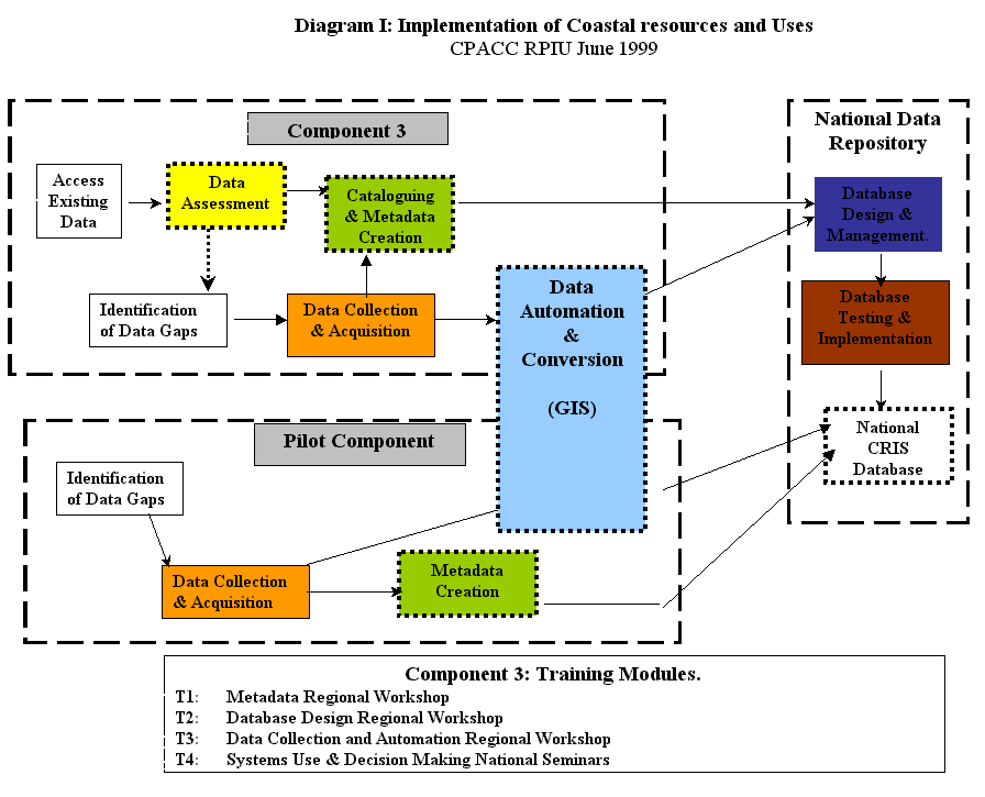
Diagram I illustrates the relationship
between the elements described and the pilot components.
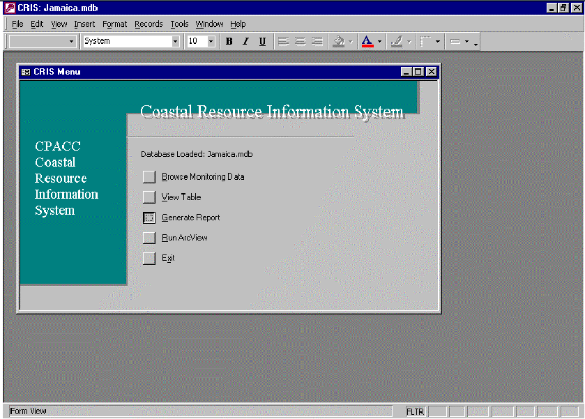
The CRIS Design
The CRIS is a database with a user
interface that allow greater access to the information by decision makers. The spatial data will be stored and
represented in Arcview GIS and the attribute data in Microsoft Access.
The CRIS main interface was designed
within Microsoft Access in order to take advantage of its extensive built-in
functionality. It allowed for a quick
and cost-effective development of a customized application with full relational
database capability. Users have the
option of either following the simple menu structure or going straight to
built-in features within Access (see Slide I).
Slide I
Users knowledgeable in Microsoft Access
can employ additional functions of that software if they wish to work with the
data more independently; the added menu structure is there for users who want
more guidance.
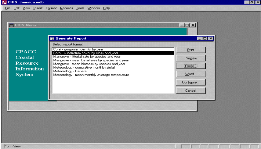
Beyond the optional menu structure,
there is the flexibility in how users can get information out of the attribute
database. Because the editing and browsing capabilities were developed directly
within Access, it is possible to take advantage of the built-in links between
Access with Word and Excel. While
Access has the built-in capability to publish any data to Word or Excel, this
capability is expanded to further allow users to send reports to customized
Word and Excel templates (Slide II).
Slide II
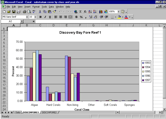
As an example, Slide III shows the
result of generating an Excel report using the CRIS. Not only will the data
appear in an Excel spreadsheet, it also automatically graphs the data. The
advantage of this feature is that users who are not very familiar with Excel
can still produce graphs from application. Users knowledgeable in Excel are
free to employ additional built-in features of Excel, if they wish to further
analyze or graph the data.
Slide III
Finally, a mapping feature was added
that allows users to view the data spatially in ArcView. Users invoke this
feature by selecting “Run ArcView” from the CRIS main menu in Access. This
opens a predefined ArcView project, and automatically displays a view
displaying basemap themes for the geographic area of interest (Slide IV).
Slide IV
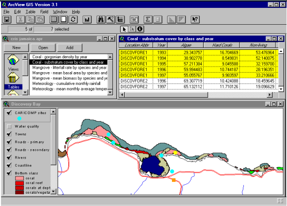
Once in ArcView, users
can open the same list of summary tables that were available in Access. Each of
these tables is automatically linked to the appropriate theme table (and
vice-versa), allowing users to do spatial queries of their coastal resource
data in two different ways. First,
users can select records in any attribute table and view the location of these
records spatially. This allows users to view their attribute data, and then
find out where these data are on a map. Secondly, users can select sites on the
map, and have the attribute data for these sites be selected automatically in
the appropriate attribute tables. This gives users the ability to zero in on
particular data sets for specific sites.
Development of the Spatial Database
Existing data in analog and digital
format will be incorporated into the CRIS.
This data was identified in the Data Assessment element for each of the
respective countries. This element
commenced with the production of a Technical Implementation Guide for a coastal
resource information system comprising of the data category, associated
variables and the data to be recorded for each variable as well as a
description of the importance of the data (Nurse and Opadeyi, 1998 – available
at www.cpacc.org). Detailed questionnaires were sent to each
country to determine data availability, quality and access. After lengthy review, data assessment and data
strategy reports were produced to inform the metadata creation, data collection
and database design. Emphasis at this
stage was on identifying reliable and relevant information for populating a
spatial database.
Under the pilot components, data needs
are identified based on the methodologies being applied and the sites being
studied. Following this process, each
country will have priorities for data collection, which would inform the
component 3 process. Field data
collection exercises are primarily undertaken in the pilot components. This
data will be georeferenced for incorporation into the CRIS, either completely
or in an aggregated format.
CPACC will also acquire remotely sensed
data to support the pilot components, with the exception of Component 9 -
Enabling the Preparation of National Communication in Response to Commitments
to the UNFCCC. The approach being
adopted is to review available remote sensing options based on the requirements
of the four pilot components being served and adopt the solution that is most
effective given the limitation of resources.
All spatial data collected, developed
and acquired will have associated metadata.
CPACC has adopted the Metalite software produced by the EROS Data Center
of the USGS and the United Nations Environment Program (UNEP) for developing
metadata records. Metalite was
introduced to several of the countries and agencies involved in CPACC in
1997/98 through the UNEP regional office in Jamaica. Further, the software represents a simplified version of the FGDC
structure but is still designed to support access through Z39.50 servers. The metadata is now available through the
CPACC Clearinghouse Node currently hosted by the EROS Data Center.
Geo-referencing Attribute Data
Geo-referencing is the process of
providing geographic or locational information to data that have been collected
for a particular phenomenon. Once data have been geo-referenced, one can create
maps to show locations of various events, query and find geographic features,
and perform other complex spatial analysis.
The geographic referencing of attribute
data may be general or specific depending on the resolution of data
collection. Methods of geo-referencing
attribute data based on whether the data is related to a general area or
specific area are presented below.
In the context of the Caribbean CRIS,
three levels of geo-referencing can be conceptualized: Country, Region (ie
administrative area within a country), and Locality (ie community or pilot
area). A hierarchical unique
identification system is proposed. The
countries of the Caribbean are at the top level. Each of the participating
countries is divided into administrative areas (e.g. Parishes or Counties) and
within each administrative area, important communities are identified. The methods for geo-referencing attribute
data collected at the general level of detail are presented below.
Country Level
At the top of the hierarchy, the
Caribbean is divided into countries. Each CPACC participating country (Figure
I) will be assigned a unique 2-character identifier, as proposed in Table I.
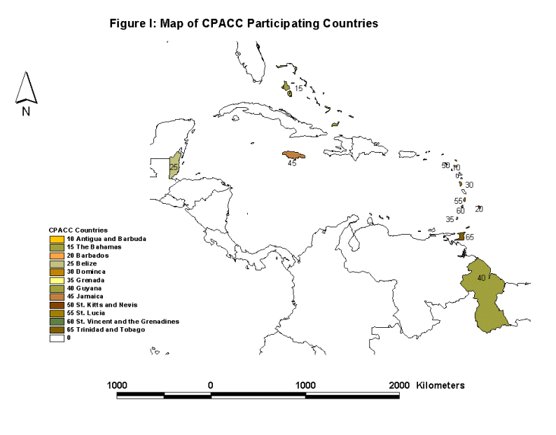
Table I: Proposed Unique Country Identifiers
|
CountryID |
Country
Name |
Variable |
|
10 |
Antigua and Barbuda |
|
|
15 |
Bahamas, The |
|
|
20 |
Barbados |
|
|
25 |
Belize |
|
|
30 |
Dominica |
|
|
35 |
Grenada |
|
|
40 |
Guyana |
|
|
45 |
Jamaica |
|
|
50 |
St. Kitts and Nevis |
|
|
55 |
St. Lucia |
|
|
60 |
St. Vincent and the Grenadines |
|
|
65 |
Trinidad and Tobago |
|
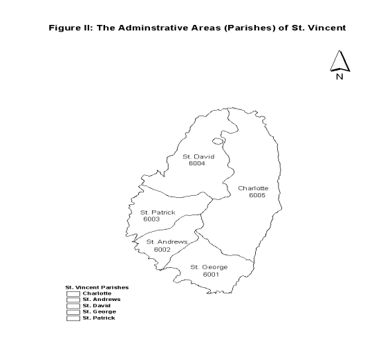
Region Level
The data model requires that each
participating country be divided into geographic Regions (e.g. Parishes or Counties) and a unique number is assigned
to each of these areas. Using St.
Vincent and the Grenadines as an example, the country is administratively
divided into six parishes (Region Name)
and an RegionID is assigned as shown
in Table II. The number structure is
xxyy: where xx is the CountryID and
yy is the assigned area number. See
Figure II for the proposed identifiers for the parishes in St. Vincent.
Table
II: Unique Identifiers for Regions within a Country
(St. Vincent and the Grenadines)
|
Region Name |
RegionID |
Variable |
|
St.
George |
6001 |
|
|
St.
Andrew |
6002 |
|
|
St.
Patrick |
6003 |
|
|
St.
David |
6004 |
|
|
Charlotte |
6005 |
|
Locality Level
The next level requires that important
communities (Locality) within each
administrative region (Region) be
uniquely identified. Table III provides examples of important localities (Locality Name) in St. George Parish in
St. Vincent and proposed unique identifiers for these localities (LocalityID). A seven digit numbering system is proposed: xxyyzzz, where xx
represents the country code; yy is the parish code; and zzz is the location
identifier.
Table
III: Unique Identifiers for Locations within an Area (St. George Parish)
|
Locality
Name |
LocalityID |
Variable |
|
Kingston |
6003001 |
|
|
Arnos
Vale |
6003002 |
|
|
Cane
Garden |
6003003 |
|
|
Greathead
bay |
6003004 |
|
|
Young
Island |
6003005 |
|
|
Indian
Bay |
6003006 |
|
Geo-referencing
Specific Spatial Features
Within each Locality, specific spatial
features are referred to as Locations.
The three models for the representation of Locations are Points, Lines, and
Polygons. Points are used to represent features whose dimensions may be
ignored depending on the resolution required.
Examples of point features are water quality sample points and the
location of rain gauges. Lines are
used to represent features in which their widths are ignored but their lengths
are considered to be important (e. g. rivers, water pipelines, sewer lines,
high water marks). Polygons are used to represent features in which their shape and
dimensions are considered to be important (e.g. wetlands, waste disposal
sites). The methods for geo-referencing
these features are discussed below.
Point
Features
Where the attribute data are collected
at a particular location referenced as a point, then a coordinate system must
be used to geo-reference the point. A
geographic system of Longitude / Latitude or a grid system of Northing /
Easting (UTM) may be used to reference the point. The choice of a coordinate system should be based on the common
practice in each of the countries.
Where possible the WGS84 coordinate system should be used especially if
the use of GPS receivers is being contemplated. Each point feature should be assigned a unique point identifier
(e.g. PointID field in Table IV) and
a pair of coordinates (Longitude and Latitude or Northing and Easting.
Table
IV: Examples of Unique Identifiers for Point Features within a Location
(Indian
Bay)
Location
Name
|
LocationID |
PointID |
Longitude |
Latitude |
Variable |
|
Indian
Bay |
6003006 |
80 |
|
|
|
|
|
|
81 |
|
|
|
|
|
|
82 |
|
|
|
|
|
|
83 |
|
|
|
|
|
|
84 |
|
|
|
Linear
Features
Where the attribute data are collected
for a particular location referenced as a line, then a system of coordinates
must be used to geo-reference the line.
A spatial database of the line feature is developed and a unique
identifier is assigned to the feature.
The spatial database would hold the coordinates and unique identifier of
the feature while in the relational table each line feature is assigned a
unique line identifier (e.g. LineID
field in Table V) and the other attributes of the line feature.
Table
V: Unique Identifiers for Line Features within a Location
(Indian
Bay)
Location
Name
|
LocationID |
LineID |
Variable |
|
Indian
Bay |
6003006 |
115 |
|
|
|
|
116 |
|
Polygon
Features
Where the attribute data are collected
for a particular location represented as a polygon feature, then a system of
coordinates should be used to geo-reference the polygon. A spatial database of the polygon feature is
developed and a unique identifier is assigned to the feature. The spatial database would hold the
coordinates and unique identifier of the polygon feature while in the
relational table each polygon feature is assigned a unique identifier (e.g. PolygonID field in Table VI) and the
other variables of the polygon feature.
Table
VI: Examples of Unique Identifiers for Polygon Features within a Location
(Indian
Bay)
Location
Name
|
LocationID |
PolygonID |
Variable |
|
Indian
Bay |
6003006 |
20 |
|
|
|
|
21 |
|
There are several options in the choice
of geo-referencing methods. The choice of a method depends firstly on the
characteristics of the spatial feature being referenced, and secondly on the
following related issues:
§
Type of data source - images favour scanning while maps can
be scanned or digitized;
§
The database model required - scanning easier for raster
while digitizing for vector;
§
Density of data - dense linework makes for difficult
digitizing;
§
Expected applications of the GIS implementation;
§
Accuracy attainable;
§
Time;
§
Coordinate and projection system;
§
Costs;
§
Sustainability of method in the local environment.
Efforts would be made to evaluate the
options and issues before commitments are made.
Capacity Building
The approach to capacity building under
Component 3 has been to ensure, at least one key agency in each country
understands the processes involved in the development of all aspects of the
CRIS, and has the basic capability to manage, maintain and develop the system
to support decision making. Further,
whereas the main focus is on an agency that has some capability to manage
spatial data, involving other agencies that are expected to be primary users of
the CRIS is another element of the capacity building strategy.
Each country was requested to designate
a lead agency for coordination of each of the regional components and their
pilot component. The lead agency for
component 3 was given the responsibility of national repository for the spatial
data and the CRIS in particular. The
intention has been to supplement the designated national repositories’
capability to manage, maintain and develop spatial databases and specifically
the CRIS. Further, the agencies through
the participants in the training are expected to contribute to the CRIS
development process. These agencies
would also be expected to provide technical support to other national agencies
likely to use the CRIS.
The training element of the process
supports the various stages of the CRIS development, particularly the data
assessment, data collection, metadata creation and data automation and
conversion (see Diagram I). The format
of the training activities undertaken to date have been regional
workshops. These have involved,
metadata development and data automation/conversion (see www.cpacc.org for workshop reports). These workshops have involved two persons
per country, usually one from the national repository and the other an agency
likely to use the CRIS such as a Fisheries Department of a Coastal Zone
Management Agency.
A third workshop addressing the
administration of the CRIS is planned for September 2000 with expected
participation from the national repository.
The final activity addressing the use of the CRIS will be based on the
final product and will be conducted through national seminars in each country,
utilizing the personnel from the agencies involved in the CRIS development
process.
Beyond
the training being conducted in support of the CRIS development, CPACC has also
sought to address deficiencies in key agencies by two main approaches. Where specifically requested, CPACC has
facilitated one-week GIS introductory classes at the national level. This was undertaken to ensure that a basic
level of confidence and understanding in the use of GIS in decision-making was
established among key national stakeholders.
This is considered a part of the preparatory process for utilization of
the CRIS. CPACC has also supported a
UWI one-year modular certificate in geographic and land information system
(CGLIS), including sponsoring participation from CPACC countries. This initiative provides more rigorous
individual development for officers from repository or lead agencies. This will also allow for application of the
CRIS.
Provision of equipment, including
ArcView 3.2 is also integral to the capacity building activities. Each of the repositories will receive computer
equipment to support their function.
Also, these agencies are being provided with ArcView 3.2 and in limited
cases Arcview extensions such as spatial analyst and 3D analyst to support
defined activities. In this latter
regard, CPACC is working with Esri and its regional distributors to ensure
adequate country support for the software acquired.
As in the case of training, individual
country needs are being assessed and additional equipment will be provided to
ensure agencies have the minimal capacity to utilize the technology introduced.
REVIEW
Up to the end of May 2000, several of
the elements of the CRIS were completed or well advanced, as in the case of
Metadata creation. Each country was
given a target of producing a minimum of 100 metadata records, which will be
hosted initially by the EROS Data Centre.
With a few exceptions due to resource limitations, this target was
realized by the end of May 2000.
The database design element of the CRIS
is on schedule and has being tested against sample data from the Caribbean
Marine Productivity Programme (CARICOMP) based at the Centre for Marine Sciences,
University of the West Indies, Mona Campus, Jamaica. Acquisition of remotely sensed imagery should commence by June
2000 and be completed by August.
The capacity building element of the
process is well advanced and proven to be successful. The intention of this element was to ensure the countries not
only understood how to use the final product, but also understood the entire
exercise and could properly maintain and develop the database and user
interface. Beyond realizing this
objective, the approach of regional workshops and the involvement of largely
the same personnel from each country has allowed a network of regional
expertise to develop which has already begun to provide support to
participating countries.
CONCLUSION
CPACC is a regional project
representing 12 countries and implementing 9 distinct components. With its limited resources, it goals are
restricted to demonstrating adaptation strategies. This is also the case in the development of the CRIS for each
country. The final product will not be
comprehensive, however, what has been undertaken is to ensure that a feasible
approach and the required capability is developed in all the countries for
taking the initiative forward.
ACKNOWLEDGEMENTS
The authors wish to express gratitude
to Mrs. Dulcie Linton of the CARICOMP Data Management Centre, Centre for Marine
Sciences, University of the West Indies, Mona Campus, Jamaica for access to the
data for testing the CRIS structure. A special thank you is also extended to Ms. Jennifer Watson who
assisted in formatting this document. Appreciation must also be expressed to the
CPACC Regional Project Implementation Unit
and in particular the Project Manager, Dr. Ulric Trotz, for permission to
document the CPACC process for the benefit of the wider scientific community.
AUTHOR INFORMATION
Information Systems Coordinator/GIS Specialist
CPACC Regional Project Implementation Unit
Lazaretto Complex, Black Rock, St Michael, BARBADOS
Telephone (246) 417-4580
Fax (246) 417-0461
Email kingcpacc@sunbeach.net
Jacob Opadeyi (PhD)
Centre for Geospatial Studies
University of the West Indies
St. Augustine, TRINIDAD AND TOBAGO
Telephone (868) 645-3232 ext. 3313
Fax (868) 662-4414
Email jopadeyi@hotmail.com or jopadeyi@uwi.eng.tt
Colin Daniel
ESSA Technologies Ltd.
1595 16th Avenue, # 301, Richmond Hill, ON L4B 3N9, CANADA
Telephone (416) 657-2170
Fax (416) 657-2172
Email cdaniel@essa.com
Leslie Walling
Deputy Project Manager/Coastal Zone Management Specialist
CPACC Regional Project Implementation Unit
Lazaretto Complex, Black Rock, St Michael, BARBADOS
Telephone (246) 417-4580
Fax (246) 417-0461
Email wallingcpacc@sunbeach.net