Archaeological statewide spatial databases are required immediately. Benefactors of such databases include archaeologists in federal, state, and local government service and in universities performing research, as well as public land and resource users who contract archaeological services prior to land disturbing activities. Implementations of such databases are underway. Building such GIS functionality is a long-term complex procedure. This presentation reports on details regarding conversion of legacy databases currently in nonspatial formats. This type conversion is done because it is a very quick way to place usable data into the hands of end users.
One quarter of a century ago Bureau of Land Management Archeologists clearly identified software functional and data requirements for GIS in order to perform the Bureau's multiple use mission. These requirements were published as the Detailed Requirements Definition (DRD) 1977. The DRD was a result of BLM Director Curt Berklund's (1973-1977) initiatives to modernize the BLM's automation environment. Director Berklund contacted IBM and commissioned development of plans for Bureau automation based upon the Bureau's Business requirements.
The Bureau's Business requirements regarding multiple use and Cultural Heritage management then and now are solidly founded upon federal mandates. In the mid-1970s these mandates including federal regulations were set forth and amplified as guidance for the Bureau's employees as the 6400 Manual. Today an up to date version of the manual (Now known as the 8100 Manual.) and a more developed Bureau Cultural program is well enough established to be recognized as able to operate without oversight on individual undertakings (land actions that may impact cultural resources). The strength of these BLM business requirements and practices are reflected in a National Programmatic Agreement (NPA) among the BLM and the National Conference of State Historic Preservation Officers (NCSHPO). (BLM's 8100 Series Manual) Further, these business requirements are still greatly dependent upon requirements for GIS.
Now as 25 years ago GIS software is required to facilitate implementation of the bureau's mission. Software development under the DRD was curtailed, but the fundamental requirements of the DRD remain valid. Neither the mandates nor the professional approaches have changed sufficiently to warrant discarding the GIS requirements identified years ago. What still must happen is implementation of operational software and databases to meet the stated GIS requirements.
Software development based upon Business requirements has recently again become the BLM's goal identified this time as Enterprise Architecture. The DRD portions of the 25 year ago efforts involved assembling the Bureau's program subject matter experts and generating a written document detailing the role of automation in accomplishing the mission by Program. [Programs in the BLM are guided by goals and objectives and include the workforce, equipment, and dollars to meet the objectives.] The mandates and professional approach to resource management have had only minor changes and additions over the years since 1977. The intent then was to design a computer system that would serve the agency's business requirements. Although the term Geographic Information System (GIS) does not occur in the DRD, it is clear in this document that the BLM's business needs for Cultural Heritage management would be served by GIS tools.
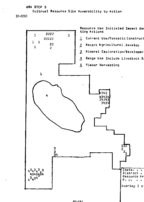
Sample DRD Pages
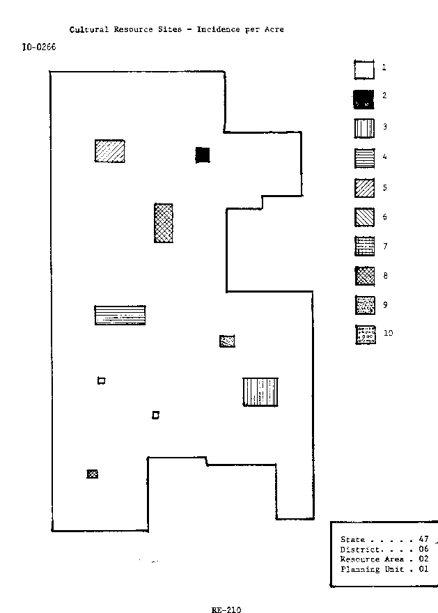
The DRD for Archeology called for over two dozen combined outputs for spatial and tabular data needed for efficient and effective Cultural Resource management. Included were needs such as Cultural Resource Existing Site Condition, Location of Sites by Affiliation Overlay, Location of Sites by Function Overlay, etc. Also included were such matters as modeling site type occurrence and distribution across the landscape.
If an obvious business need for software has existed for 25 years, what progress has been made toward meeting those needs? Where are we regarding systems to serve our legitimate business needs for GIS software?
There is likely a critical four-year hiatus in the BLM's GIS history. Director Frank Gregg (1977-1981) apparently did not follow through with the plans of IBM and his predecessor, Curt Berklund. The DRD foundation work for automation with GIS of the Bureau's resource program business has lain dormant since their formulation. To my knowledge these documents have been unknown or at least not used by the Automated Lands and Minerals Records System (ALMRS) and other IT efforts. I believe that the documents were not consciously discarded, but rather simply forgotten in the changes of emphasis, administrations, leadership and management.
All this early 1970s IBM effort was prior to the domination of the Bureau's IT efforts by ALMRS which dealt with that portion of the BLM's business dealing with case records, land status, adjudication, etc. The ALMRS effort deferred dealing with the "Resource Program's" (Forestry, Minerals, Recreation, Wild Horse and Burro, etc.) side of BLM's business until ALMRS was completed. Please note that in the early 1980s as the Bureau's adjudicators identified requirements for what would be the ALMRS effort, the system was believed to include and sold as including the Resource Programs requirements. (Ken Smith, 2000).
As the complexities of the various BLM State Offices case recordation systems and automating these became apparent, management scaled back the scope of the effort to case records only. It is well known now that the ALMRS project did not end well. And BLM GIS (and automation of resource program business needs) progress other than dedicated individual effort was virtually halted during the ALMRS era that just ended less than a year ago. GIS was erroneously believed to be in competition with ALMRS.
From about 1984 forward Divisions and Branches of GIS did exist in the BLM. First, these groups were to support the Public Domain Software the "Map Overlay and Statistical System" (MOSS). When the ALMRS contract was let about 5-6 years ago and Esri Inc. software was acquired for ALMRS, the GIS groups existed a bit longer for the purpose of addressing the spatial aspects of ALMRS, that is, Plats.
During the MOSS years a considerable amount of in depth understanding of all aspects of GIS, including training, GIS code writing and maintenance, and user support was vested in the Denver Service Center. The entire Bureau relied upon this expertise. But MOSS was only for the very dedicated folks. MOSS was perceived as being quite difficult to use and not for the faint hearted or the busy resource program folks. However, a rather considerable "resource" side GIS development occurred throughout the BLM that has carried over as a cadre of GIS expertise who now enjoy the benefits of Esri Inc.'s GIS softwares. This core group is scattered throughout the Bureau and for the past several years has held annual GIS Workshops. At the BLM GIS Wrodshop 2000 this April the need for a cohesive GIS approach under a "Champion" in the Bureau's Washington D.C. headquarters was identified. In addition to a champion the Bureau must have a program for GIS support with goals and objectives and including the workforce, equipment, and dollars to meet the objectives.
Over the past several years implementation of GIS capabilities for Archeology in the Western U.S. has followed a course that I outlined at last year's conference. (See: Martin, 1999)
At outset this initiative was poorly coordinated with the Bureau's GIS capabilties. Unbeknownst to the Bureau's most active Archeological GIS advocates and the BLM Denver Service Center Branch of GIS, a group of State Historic Preservations Preservation Officer's (SHPO) archivists and data administrators led by Wyoming State Government staff assembled during 1992. This group became interested in the feasibility of GIS for State Historic Preservation Officer (SHPO) database use. The National Historic Preservation Act of 1966 created the function of the SHPO and one of the functions was to serve as a centralized information repository for site records.
Under a Small Business Innovation Research (SBIR) Program of the National Science Foundation a study was generated to review the use of GIS by the SHPO. The study targeted the offices of SHPO group assembled in 1992. The title of that study is "A Study of the Feasibility of Developing Generally Applicable Methods and Techniques for the Conversion of Existing State Cultural Resources Databases to Geographic Information Systems".
Not surprisingly, use of GIS by SHPO's was endorsed by the study. The study estimated the implementation costs Nation-wide. The caution that cost could be considerably higher if the approach is "haphazard" is offered. The document acknowledged that State government would be unlikely to generate that type of revenue for such purposes and no firm answer as where funding would come from for such an undertaking is offered. The study provided estimates as to costs associated with various GIS activities, but no detailed state by state breakdown peculiar to specific conditions of the tasks, costs, resources (personnel, skills, or equipment), nor any state specific time frames. The study clearly states GIS are desirable for Statewide Archeological databases and the virtually all States desire to pursue such databases.
The National Historic Preservation Act of 1966 as amended through 1992 states that:
"Subject to subparagraphs (C) and (D), the Secretary may enter into contracts or cooperative agreements with a State Historic Preservation Officer for any State authorizing such Officer to assist the Secretary in carrying out one or more of the following responsibilities within that State- . . .
(iv) Maintenance of historical and archaeological data bases."
(Emphasis added).
Further, NHPA states "The Secretary may enter into a contract or cooperative agreement under subparagraph (A) only if-
(i) the State Historic Preservation Officer has requested the additional responsibility;
(ii) the Secretary has approved the State historic preservation program pursuant to section 101(b)(1) and (2);
(iii) the State Historic Preservation Officer agrees to carry out the additional responsibility in a timely and efficient manner acceptable to the Secretary and the Secretary determines that such Officer is fully capable of carrying out such responsibility in such manner;
(iv) the State Historic Preservation Officer agrees to permit the Secretary to review and revise, as appropriate in the discretion of the Secretary, decisions made by the Officer pursuant to such contract or cooperative agreement; and
(v) the Secretary and the State Historic Preservation Officer agree on the terms of additional financial assistance to the State, if there is to be any, for the costs of carrying out such responsibility." (Emphasis added).
Given the desirability of using an authoritative data set maintained by an agency that the Bureau consults with by Law regarding its undertakings that may impact cultural properties, the Bureau's Washington Office in 1996 joined the SHPO's efforts to implement GIS databases.
As I stated at last year's conference "The overarching goal of the BLM's SHPO Data sharing initiative is that Cultural Heritage (Archeologists, Historians and Historic Architects, etc.) Personnel will have a state of the art spatial data management system for accessing and manipulating site inventory records." Realization of this goal would fulfill the vision and insight of the 1977 DRD.
Further, last year I stated that under such great "responsibilities as the BLM has, the spatial data system for its cultural heritage staff must:
require low maintenance and learning by users
reflect current SHPO data
interface directly with other BLM data
be capable of spatial analysis including:
The Focus of SHPO Data sharing effort must be Cultural Heritage end-users"
Joining other agencies in support of the SHPO's GIS initiatives, the Bureau has spread about $200,000.00 per year among the Western SHPOs for the past several years. Last year at this conference I identified some tasks needing to be undertaken and a review of progress at that time. Since that time in late March of this year a genuine management requirement has been levied against the SHPO's GIS databases. I will use that requirement as a measure of how well the SHPO Data Sharing efforts meet BLM spatial data needs presently.
Last January the Bureau of Land Management's Executive Leadership Team (ELT) instructed the Bureau's National Assessment team to create a set of prototype maps that could be used in budget requests and justifications. Those funding requests will be applicable to individual programs as well as the Bureau. The maps must provide easily understood documentation on the status of resources and resource management.
The intent was to put together a set of small scale (1:12 million) maps that summarize cultural resources status across the western United States. The thematic maps of data would be aggregated by hydrologic unit code (HUC) sub-basin. The sub-basin units will be keyed using colors, shading, dot density, or similar cartographic techniques to show the values of the aggregated data. Archeological sites locations are protected by law from release, however, at the scale 1 inch equals 190 miles, there will be no question of giving away confidential locations.
The data from SHPOs was requested under three options:
Option 1. Send a file of x, y coordinates for resources with the requested attributes as extra columns (a spreadsheet with coordinates would work, for instance). The Bureau GIS specialists will then import the tables to spatial form using "Add Event Theme". A .dbf-format file or Excel file was the preferred format.
Option 2. Send a table that summarizes the above data by the 8-digit hydrologic unit code using the standard USGS second order HUC codes as row identifiers.
Option 3. Send ArcInfo coverages or ArcView shapefiles with the appropriate attributes. If sending spatial information (either tables with coordinates or GIS files) please include the coordinate system information and any other relevant metadata.
The specific aggregated data requested from the SHPOs of interest was:
number of sites per sub-basin
number of eligible sites per sub-basin
number of listed sites per sub-basin
number of National Historic Landmarks per sub-basin
the average size of sites in the sub-basin (in acres)
the standard deviation in size of sites in the sub-basin (in acres)
numbers of sites in each of the following general condition categories:
total acres inventoried in the sub-basin
To date this work is in progress, because the final prototypes will be submitted in July 2000. However, with the exception of Arizona that is delayed in its response, the SHPO's have responded with their data within their current capabilities. Most SHPOs responded using option 1 above. Following is the map product generated by the Bureau's GIS specialist.
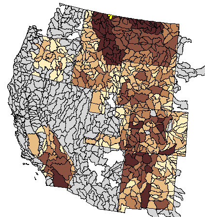
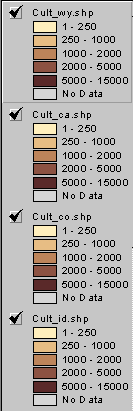
As the map now stands the sites per sub-basin may interpreted variously. That is, high numbers of sites (the 5000-15000 range) may indicate a high level of inventory within the sub-basin, a high number of actual sites, or just a large basin that will yield high numbers of sites.
Given the data available from the SHPOs the only consistently available data category among the States at present is "number of sites per sub-basin" The following chart summarizes the data requirements met against the data requirements requested. Note the percent column in the lower right corner.
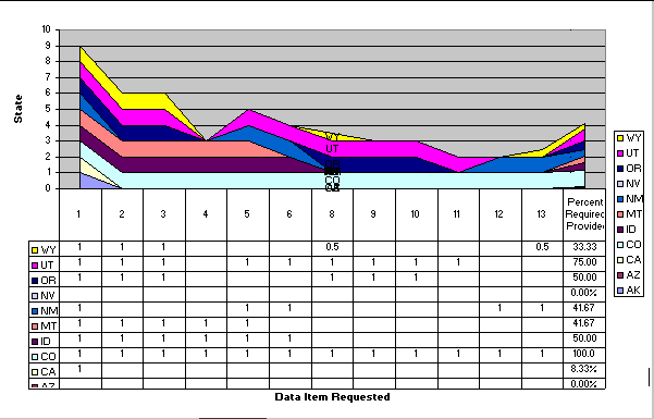
Chart X-axis Column Header Data Values.
13. total acres inventoried in the sub-basin
Progress is being made regarding our goals and objectives for Cultural Heritage Spatial Data sets accessible and useable by Bureau Archeologists. The excellent data requirements and their management use toward the Bureau's land management mission are encouraging. A future goal is to have the full data categories from the SHPO in spatial format and accessible to the BLM field office archeologist as envisioned in 1977.
In conclusion I wish to present one beta version solution to a challenge presented concerning Alaska SHPO data in my last year's paper. I'd proposed making a legacy database useful to field office archeologists with "quick and dirty" databases solutions in order to generate support for GIS use among prospective end users. But the current situation of the Alaska SHPO's data structure made the GIS implementation not fully useful.
Happily, improvements in ArcView 3.2 regarding dealing with Binary Large Objects (BLOBS) make a solution possible. Last year's paper stated "One Alaska database issue that we are still working on is bringing in dBase 'Memo Fields'. . . . a major obstacle to BLM Cultural Heritage staff's benefiting from use of the Alaska SHPO's AHRS.dbf. . . . . some of the most useful information about sites is found in the SHPO's three AHRS.dbf memo fields, 'DESCRIPTION', 'SIGNIFICANCE' and 'LOCATION'".
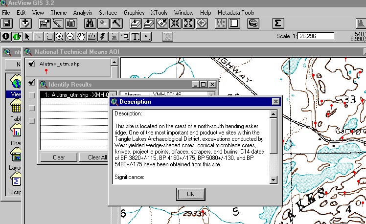
Note that the tool bar has two identity buttons. The standard button brings up the "normal" attribute data from dBase. The other button brings up the "Memo Field" data.
This solution suffers at present from a problem described below that I ask readers to offer aid in finding resolution.
This single record was taken from the Alaska SHPO's "raw" export file as accessed with MS-Access. The "bad" characters are present. This could mean that they appear when they are accessed by MS-Access or they pre-existed from the dBase export.
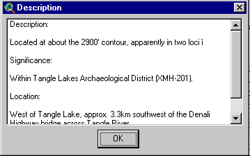
The problem lies in the appearance of a Latin small i, grave accent (Octal 236, Decimal EC, Hexadecimal 354) followed by a Line feed (012, 10, OXa) in some of the "Memo/blob" fields.
The consequence of such characters is that the data following fails to appear (being truncated) in the information box. An example may be found in the blob fields for site number XSL-00051. The bothersome characters appear between "possible" and "cemetery" as well as between "to" and "1935".
AHRSNO SITENAME DESCRIPTN SIGNIFIC LOCATION MAPSHEET LATITUDE LONGITUDE STRM MTRS UTM CDCHECKED AREA CITATIONS1 CITATIONS2 CITATIONS3 CITATIONS4 DESTRUCT CONDITION ENVIRON DATE PERIOD RESNAT CULTURE PRESERVE NHRDATE OWNER REPOSITORY ACCESSION BIANO OTHERNO ENTRYDATE RELIAB CODEDBY UPDATE XSL-00051 PUGUGHILEQ (POWOOILIAK, PUGUVILIAK) "Three midden areas, several house pits, tent(?) sites, a possible ě cemetery area, and three trapping cabins. Occupied at least to ě 1935. Probably occupied during Punuk-late prehistoric period." At Powooiliak Point, approx. 10km northeast of Southwest Cape, St. Lawrence Island. N/A xxxxxx xxxxxxxW SEC.3x,T2xS,R6xW,KRM Ackerman, R.E. 1961:22 Geist, O.W. and F.G. Rainey 1936:10 B 0417 Prehistoric/Historic Site Punuk, Eskimo Sivuqaq, Inc. Crowell's #48 1/16/85 A1 SK 9/30/86
Here is the result of the "Latin small i, grave accent" on the "Description" box.
Bureau of Land Management, User Specifications for a Recreation Inventory and Unit Resource Analysis Data System: Phase I Detailed Requirements Definition, Denver: BLM Document, 1977.
Bureau of Land Management, 8100 Series Manual, Washington, D.C.: BLM Document, 2000.
Ebert & Associaties, Inc., "A Study of the Feasibility of Developing Generally Applicable Methods and Techniques for the Conversion of Existing State Cultural Resources Databases to Geographic Information Systems - Final Phase I Research Report submitted to the Small Business Innovation Research (SBIR) Program, National Science Foundation", Albuquerque, 1994
Ebert & Associaties, Inc., "Generally Applicable Methods and Techniques for the Conversion of Existing State Cultural Resource Archives to Geographic Information Systems Databases -Phase II Proposal submitted to the Small Business Innovation Research (SBIR) Program, National Science Foundation", Albuquerque, 1994
Martin, Dan, "Archaeological Spatial Databases for the Western U.S.:Implementation of SHPO Data sharing in the Western U.S.", Redlands, 1999. (See Martin, 1999)
Smith, Ken, Personal Communication, Denver, 2000.
These ongoing large scale efforts referenced in this paper are the result of many contributors too numerous to enumerate here. I wish to single out two who some years ago provided excellent instruction in ArcView and Avenue when first released and that have continued to correct my homework. These two are Mike Badar, Esri Inc. Denver (Esri Inc.'s very capable man at BLM) and Dave Newfield, Esri Inc. Denver. Any errors or misrepresentations are solely the author's responsibility.
Dan Martin
Archeologist, GPS/GIS/RS,
BLM
Building 50
DFC
PO Box 25047
Denver, CO 80225-0047
(303) 236-0105 Voice, (303) 236-3508 FAX,
Dan_Martin@blm.gov